
|
Geological Survey Professional Paper 669
The Colorado River Region and John Wesley Powell |
DESCRIPTIVE GEOLOGY
(continued)
Grand Canyon to the Gulf of California
In crossing the Basin and Range province from the Colorado Plateau to the Gulf of California, the whole aspect of the Colorado River valley changes. Alternately, the river flows in unconsolidated gravels and sand that fill broad open structural valleys and in deep, narrow, rock-walled canyons through block-faulted mountains separating the valleys.
During early Tertiary time when the surface of the Colorado Plateau remained near sea level, except perhaps at the upwarps, the Basin and Range province was subjected to intensive deformation, including folding, thrust faulting, and both intrusive and eruptive igneous activity. Drainage off the Colorado Plateau became disrupted by structural depressions in the Basin and Range province. When drainage from the Colorado Plateau first began discharging to the Basin and Range province is problematical.
The geology at the Peach Springs dry canyon indicates clearly that a sizable river was discharging there from the plateau more than 18 million years ago, and it had been discharging long enough before that to have eroded a canyon 1,000 feet deep. The drainage course must be as old as early Miocene and could be late Oligocene. By my interpretation, this canyon first was cut by the Little Colorado River and enlarged later by the ancestral San Juan River.
Whatever river carved the canyon at Peach Springs, it antedates the volcanic and gravel deposits that partly fill the canyon, and all traces of the river are lost in the Basin and Range province. Some of the possible early Miocene river courses in that part of the Colorado River basin are suggested by reconstructing the early Miocene landscape there.
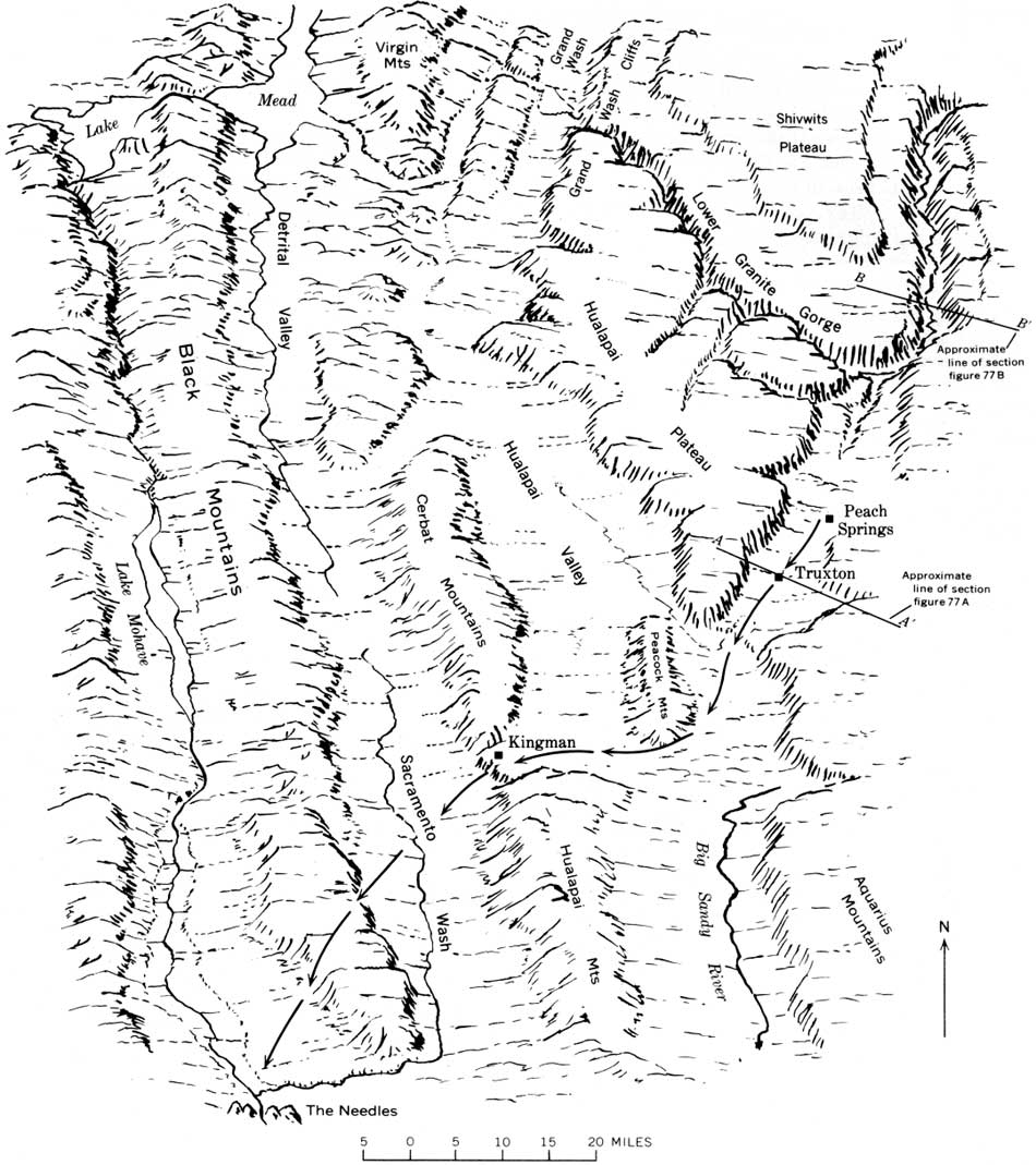
The probability is that in early Miocene time, the Hualapai, Cerbat, and Virgin Mountains (fig. 79), which are composed largely of Precambrian rocks, still were attached to and part of the Colorado Plateau, or had just begun to be faulted away from it. This is more than idle conjecture, because on the Colorado Plateau is evidence that mountains of Precambrian rocks in this area shed sediments northeastward onto the plateau; these old gravels antedate some of the lavas on the southwest rim of the plateau. Further, much of the faulting is later than the lavas that are in fault blocks broken away from the rim.
|
| FIGURE 79.—Basins and ranges west of the Grand Canyon, and possible course of the ancestral Colorado across them. The dry canyon at Peach Springs is pre-middle Miocene in age. The ancestral Colorado River probably discharged southwest through it and perhaps continued southwest through the gap at Kingman between the blocks of Precambrian rocks forming the Hualapai and Cerbat Mountains. The gap is filled with volcanic rocks, probably of Miocene age. The south end of the Black Mountains is a major volcanic center and may have contributed the volcanic deposits at Kingman and at Peach Springs. In Pliocene time, an estuary of the Gulf of California extended northward to The Needles. (click on image for an enlargement in a new window) |
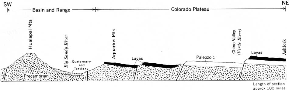
It is tempting to turn the early Miocene drainage from the dry canyon at Peach Springs southward into the valley of the Big Sandy River, but if the Big Sandy was in existence in early Miocene time, its valley was probably a broad open strike valley on a fault block just beginning to separate from the Colorado Plateau, like the present Chino Valley at the head of the Verde River (fig. 80). The Big Sandy River valley in its present form appears to be a late Tertiary structural valley.
|
| FIGURE 80.—Diagrammatic section northeast from the Hualapai Mountains to Ashfork, Ariz., to show contrast in the strike valleys occupied by the Big Sandy River and by the head of the Verde River (Chino Valley). The more southwesterly faults have the greater displacement and probably are older. (See also Twenter, 1961, fig. 205.3). In early Miocene time, the strike valley at Big Sandy River was probably just beginning to form and was similar to the present strike valley at Chino Valley. Under the lavas, at many places on the Colorado Plateau, are stream gravels derived from the mountains of Precambrian rocks that have been separated by faulting from the Colorado Plateau. (click on image for an enlargement in a new window) |
At Kingman, Ariz., between the block of Precambrian rocks forming the Hualapai and Cerbat Mountains is a gap (fig. 79) partly filled with volcanic rocks that resemble the other middle Tertiary volcanic rocks in that region. The lava seems to have flowed into the gap rather than being faulted into it; if so, the gap is old and may very well be a segment of the ancient valley that extended west from Peach Springs. I looked for river gravels under the lava but found none.
Both the geomorphology and the structural geology provide a little support for inferring that the ancient drainage was west at right angles to the present basins and ranges. Beyond the gap at Kingman is an even thicker series of volcanic rocks in the south end of the Black Mountains; this may have been the eruptive center that supplied the Miocene volcanic material that spread eastward into the canyon at Peach Springs.
This volcanic center is near what may have been the mouth of the ancestral Miocene drainage. As will be noted shortly, the Colorado River valley downstream from here was an estuary of the Gulf of California, at least in early Pliocene time. Before considering that part of the river's history, though, the modern river valley below Grand Canyon should be briefly described.
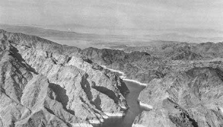
After leaving the Colorado Plateau, the course of the modern river, like the presumed course of its predecessor, is westward, at right, angles to the basins and ranges. At Hoover Dam, the river turns south approximately parallel with the grain of the topography. We have inferred that the Colorado River reached the Lake Mead area by underground drainage in middle or late Pliocene time when the Hualapai Limestone was deposited. The area was and still is tectonically active. Angular unconformities in the Muddy Creek Formation show that the basins and ranges were being formed while that fill was accumulating in the basins (see for example Longwell, 1936, p. 1420; Hunt, McKelvey, and Wiese, 1942, p. 301). Early Colorado River gravels that possibly are as old as late Pliocene are turned up steeply along the northwest foot of the Black Mountains (Longwell, 1936, p. 1466) and show that the downfolding and downfaulting of the basins continued in Pleistocene time. Younger sand and gravel deposits (Chemehuevi Formation), in part lake beds and regarded as Pleistocene but not well dated (Longwell, 1963, p. E12-E15), are little deformed. The river was superimposed across the south end of the Virgin Mountains and probably across the Black Mountains (fig. 81), but subsequent uplift of the ranges almost certainly means that the canyons are antecedent. Each time a range like the Black Mountains was uplifted, the elevated canyon bottom would become the spillway for overflow of the river ponded above it, and the canyon would be deepened to drain the ponded waters. If the episodes of uplift were slow enough, there need not have been much ponding, and the downcutting would keep pace with the uplift.
|
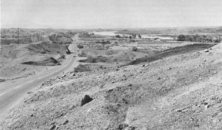
| FIGURE 81.—Canyon of the Colorado River through the Black Mountains, view down valley. The river was superimposed across this fault block of Precambrian rocks at a time when the fault block was substantially lower than it is now. Subsequently, as the block continued to rise, the river deepened its canyon. |
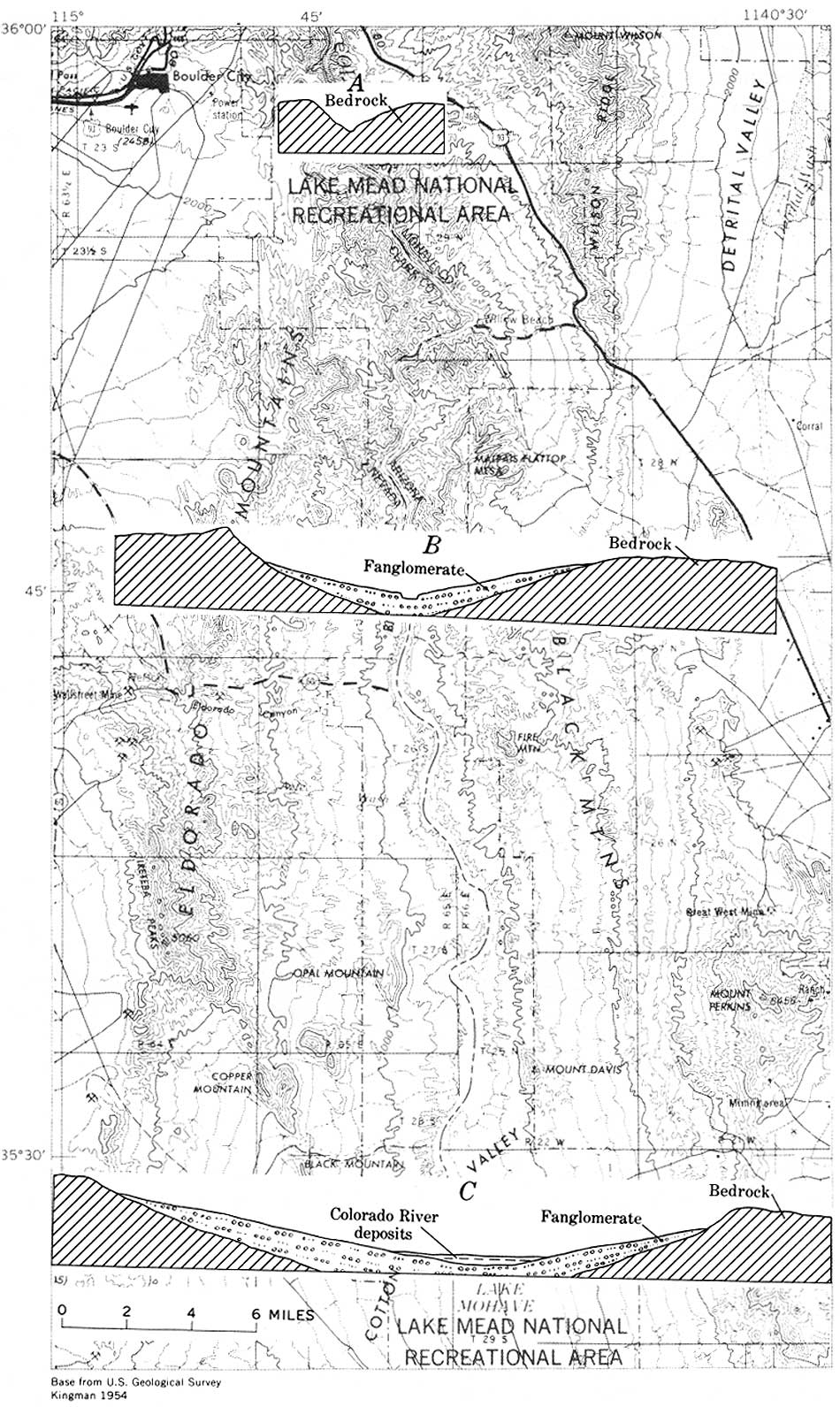
The Colorado River turns 90° south near Hoover Dam. From there to the head of the delta near Yuma, three valley forms are found (fig. 82): (1) Gorges through bedrock barriers; (2) open but narrow valleys between bluffs cut into locally derived gravel fans (fig. 83); and (3) wide flood plains on Colorado River deposits overlapping the gravel fans. Drilling records indicate the fan gravels may in places be 2,000 feet thick (Metzger, 1965).
|
| FIGURE 82.—Colorado River valley between Hoover Dam and Davis Dam, Cross sections show: A, gorge through area of bedrock uplift; B, narrow valley between fanglomerate bluffs immediately downstream from the area of bedrock up lift; C, broad flood plain of Colorado River deposits that bury the lower ends of the fans. This flood plain ends downstream at the next uplift. These three valley forms are repeated several times between Hoover Dam and the Gulf of California. (click on image for an enlargement in a new window) |
|
| FIGURE 83.—The open valley of the Colorado River below the bedrock gorge at Parker Dam; view downstream. Fanglomerate in river bluffs. Bluffs become farther apart downstream and are separated by a broad flood plain of Colorado River deposits. |
Unconformably overlying the fan gravels, and extending under the Colorado River gravels, Metzger found beds of limestone, clay, and sand containing Foraminifera indicative of brackish water (Metzger, in McKee and others, 1967, p. 3; Metzger, 1968.) With the Foraminifera are algae, barnacles, pelecypods, and ostracods (Hamilton, 1960, p. 276). Also found with these fossils are coccoliths from Cretaceous formations (Patsy J. Smith, written commun., May 1968); presumably the coccoliths were derived from the Colorado Plateau.
The estuarine deposits first were regarded as upper Miocene or lower Pliocene (McKee and others, 1967, p. 3) on the basis of probable correlation with the Imperial Formation (see also Wilson, 1931, 1933; Woodring, 1931; MacNeil, 1965, p. 8) which also contains fossils (Foraminifera) identified as being reworked from Cretaceous shale on the Colorado Plateau (Merriam and Bandy, 1965). Later work suggests that the deposits along the Colorado River are Pliocene (Metzger, 1968). The marine (or brakish-water) fauna in these deposits has been found as far north as Parker, and similar deposits without the fossils are reported in the basins upstream and near the big volcanic center at the south end of the Black Mountains, possibly the mouth of the ancestral drainage westward from the Colorado Plateau at Peach Springs.
On the Riverside Mountains (west side of the river, below Parker) the estuarine deposits are at least 800 feet in altitude (Hamilton, 1960, 1964), 500 feet higher than the present Colorado River; near the mountains the beds are tilted as much as 19° (Metzger, 1963, p. 15). In The Needles region, similar deposits are 1,500-1,800 feet above sea level (D.G., Metzger, written commun. 1968). There must have been this much uplift since the Gulf of California extended into and flooded the lower 200 miles of the Colorado River valley. As already noted, the fanglomerates that underlie the estuarine beds are presently at least 2,000 feet thick; at the time of the estuary, therefore, the basins must have been downwarped at least 3,000 feet.
As uplift progressed and the estuary drained, the Colorado River discharged along the basins. Metzger (in McKee and others, 1967, p. 3) notes that river deposits occur as deep as 600 feet below and as high as 450 feet above the present flood plain. The oldest river deposits are younger than the ancestral drainage westward from Peach Springs; that is, they probably are no older than middle Pliocene.
The Colorado River from Hoover Dam to the mouth separates two very different kinds of drainage systems (fig. 84). On the east, the river is joined by through-flowing drainage of the Gila and Bill Williams river systems. The Gila and its tributaries are in long longitudinal valleys between the mountain ranges, and they cross the mountains in deep gorges. The base of the fills in many of the longitudinal valleys is lower than the bedrock in the gorges across the ranges. The streams may have been ponded by uplift at the mountain barriers and maintained their courses by overflowing and cutting downward at the gorges; along the lower Gila, the basin fills may include estuarine deposits like those along the Colorado River (Metzger, 1968). This is a tectonically stable area with few earthquake epicenters (fig. 85).
|
| FIGURE 84.—Contrast in drainage east and west of the Colorado River where it flows south between Arizona and California. On the east is an integrated system of tributaries; on the west the tributaries have been interrupted by late Tertiary and Quaternary earth movements, and the drainage that formerly was tributary to the Colorado is now ponded in a series of playas. |
|
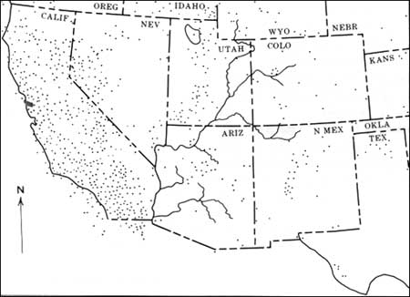
| FIGURE 85.—Earthquake epicenters in southwestern United States (from Childs and Beebe, 1963, p. 131). The southerly course of the river between Arizona and California separates a structurally stable area on the east that has dendritic drainage from a structurally unstable area on the west that has interrupted drainage. Structural instability of the area west of the Colorado River is indicated by recent fault scarps and measurable earth tilt as well as by the many earthquake epicenters. |
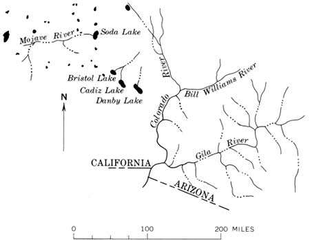
On the west side, the Colorado River has no tributaries worth the name. The theory is that the Colorado River once was joined by the Mojave River draining via Bristol, Cadiz, and Danby dry lakes, and that this drainage became disintegrated by the earth movements. This is a tectonically active area with many earthquake epicenters. The evidence that the Mojave Desert drainage once connected with the Colorado River is provided by the fishes now isolated at springs in the desert, for they are species related to those in the Colorado River (Hubbs and Miller, 1948).
Also, Foraminifera like those in the estuarine beds along the Colorado River have been discovered recently in drill cores at Danby and Cadiz Lakes (Smith, 1960). This strongly suggests that the estuarine beds extended at least as far northwest as Cadiz Lake, but the same species have also been found in cores at Panamint Valley, the valley west of Death Valley. It is difficult to visualize a water connection extending that far (Smith, 1960), although if the Foraminifera are as old as early Pliocene, a very different terrain might make a connection conceivable. Judging by inferred rates of speciation of the fishes, Hubbs and Miller (1948, p. 94) suggested that the Colorado River was well integrated, hydrographically and faunistically, as recently as late Pleistocene time. This may be so, although a greater age for the integrated drainage and slower rate of speciation seems indicated.
The former outlet of the Mojave River may have been at the Big Maria Mountains (at the pass south of Quien Sabe Peak). The fanglomerate east of the mountains contains very well rounded pebbles mixed with the subangular and subrounded locally derived fanglomerate (Hamilton, 1964). The rounded pebbles, constituting perhaps one part in a million of the fanglomerate, are evidently reworked from a still unidentified gravel bed. The gravels do not look like the Colorado River gravels derived from the northeast; they include rocks like those in the Mojave Desert—quartzite like the upper Precambrian quartzite and dark chert like that occurring abundantly in the Paleozoic limestones.
| <<< Previous | <<< Contents >>> | Next >>> |
pp/669/secc8.htm
Last Updated: 22-Jun-2006