
|
Geological Survey Professional Paper 669
The Colorado River Region and John Wesley Powell |
RESPONSE OF A RIVER IN A ROCK CANYON
(continued)
Nature and Transport of Material on the Riverbed
The nature of the material on the riverbed can be inferred primarily from three kinds of observations. The bed was exposed to direct observation when the foundations were excavated for both Hoover and Glen Canyon Dams. In the foundation excavation for Hoover Dam, a sawed plank was found imbedded in sand and gravel 55 feet below the normal streambed elevation. This implies that the sand and gravel found in the canyon bottom moves to considerable depths during floods.
Most channel bars exposed at low flow consist of sand and cobbles. Large boulders occur primarily on fans directly attributable to debris from tributary canyons.
Though the streambed includes in places extremely large blocks of rock, for the most part the variation in water depth, typified by the bed profile shown in figure 89, seems to be caused by local scour in a bed composed primarily of sand and gravel. This is supported also by the particle sizes of sediment deposited at the head of Lake Mead; this sediment consisted of 45 percent sand and 55 percent silt and clay (Smith and others, 1960). The relatively fine texture of the bed material is perhaps most persuasively demonstrated by the fact that the riverbed is scoured deeply during floods in all observed sections of the river that were or are still unaffected by dams in the reaches immediately upstream. Data on the depth of riverbed scour during the spring run-off peak have been described previously at some length (Leopold and Maddock, 1953, p. 30-35). However, the previous discussions have, for the most part, omitted the changes throughout the nonflood season, which are important to the present discussion.
Figure 96 shows the changes in some of the principal hydraulic factors at Lees Ferry during a 10-month period from December 1947 to September 1948. These data represent conditions in the Grand Canyon prior to the construction of Glen Canyon Dam and several other dams farther upstream. The spring flood in 1948 was moderately high but far below the maximum of record. The discharge was 92,100 second-feet on May 25. During this season, as the discharge increased progressively from about 10,000 second-feet, the water-surface elevation rose 11 feet, but simultaneously the mean elevation of the riverbed fell 16 feet. In other words, the accommodation of the river channel to the increased flow consisted of an increase in cross-sectional area achieved somewhat more by riverbed scour than increase in water-surface elevation. After the 1948 flood, the water-surface elevation returned to approximately its preflood value, but for several months after the flood recession, the average bed elevation remained 2 to 3 feet lower than in the preflood conditions. In the fall and winter months, the average elevation of the streambed rose gradually to its average springtime condition.

|
| FIGURE 96.—Changes in discharge, water-surface elevation, bed elevation, and mean velocity during a 10-month period at the Lees Ferry measuring station, Colorado River. Note that the streambed had been scoured 16 feet between mid-April and late May as the discharge increased. (click on image for an enlargement in a new window) |
The hydraulic relations during such riverbed scour were discussed in detail by Leopold and Maddock (1953). The scour at Lees Ferry was shown to be associated with high suspended-load concentrations, and for a given discharge, during the recession side of the flood, the sediment load was smaller and the streambed elevation was lower than on the rising flood stage. The scour cannot be attributed merely to high velocity because, as shown in figure 96, the most rapid rise of discharge was associated with deepening of the riverbed which was also coincident with a decrease in the mean water velocity. At the end of August 1948, when the discharge was the same as the preflood values of the preceding January, the mean velocity was lower than had typified the January conditions.
The stations at Grand Canyon and San Juan River at Bluff filled and then scoured on the rising flood stage; the bed changed but little on the falling stage. Thus, during a snowmelt flood, the Colorado River had a large variation in sediment load and changed the elevation of its streambed and the cross-sectional area of its flow as it simultaneously changed its mean water velocity. These hydraulic adjustments were associated with a changed bed roughness in response to changes in sediment transport.
We see, then, a complicated adjustment of the river bed roughness, crosssectional area, and bed forms brought about by different conditions of water and sediment inflow.
Before the dams were built, the sediment transported through the Grand Canyon averaged about 143 million tons per year, as indicated by sediment accumulated in Lake Mead during the first 14 years of the reservoir's existence. The year-to-year variation in the amount of sediment transported through the canyon in the pre-dam condition was large. For example, in the year 1927, the measurements show that 480 million tons were transported past Grand Canyon station.
As the spring flood passed, not all the sand and gravel that was temporarily cut out of the streambed moved completely through the canyon into the lower reaches of the river. The interrupted motion of individual grains of sand or gravel cobbles was an alternation between transport and resting or waiting in a dune or bar for extended periods of time. The average downstream speed of a cobble was very much slower than the average speed of any water particle. For this reason, the total volume of riverbed scour during a flood is large compared with the volume of sediment accumulated in a downstream reservoir as a result of the same flood passage.
The low-gradient pools of a canyon river are visualized as local basins of semipermanent character cut into a bed consisting primarily of sand and gravel. These sections of the riverbed are scoured deeply during flood passage, and after the flood has passed they slowly regain their original topography.
I hypothesize that the areas of rapids, on the other hand, are nearly fixed features, consisting of heavy gravel, only the surface rocks of which move during flood periods. As in other smaller rivers in which we have made observations of marked rocks placed on river bars and riffles, the usual flood moves only rocks lying at or near the surface. These are immediately replaced, however, by similar rocks derived from upstream. Scour of the material of the rapids during a flood is, therefore, nearly inconsequential compared with the deep scour that occurs in the finer grained material of the pools or deeps nearby. Despite the ability of the river to transport the gravel and boulders that form the bulk of any given rapid, the flow mechanics require, for long-term stability, that the riverbed not be a smooth sloping plain, but consist of alternating deeps and shallows which, even through long periods of time, remain in a consistent geographic position.
The main difference between the bed topography in a deep narrow gorge like the Grand Canyon and the common gravel-bedded stream of less mountainous areas is a matter of scale. A river develops a profile connecting the high-elevation headwaters with its mouth or base level by a channel which along its length represents a quickly attained quasi-equilibrium, constantly adjusted through geologic time as the elevation difference between headwaters and mouth is gradually reduced. The concavity of the profile in most rivers is primarily the result of increased discharge as tributaries enter along the river length. Along the Colorado River through the Grand Canyon, the addition of water from tributaries is negligible. The river profile through the Grand Canyon, when drawn at such a scale that the pool and rapids alternation is obscured, is nearly a straight line, as can be seen in figure 97.
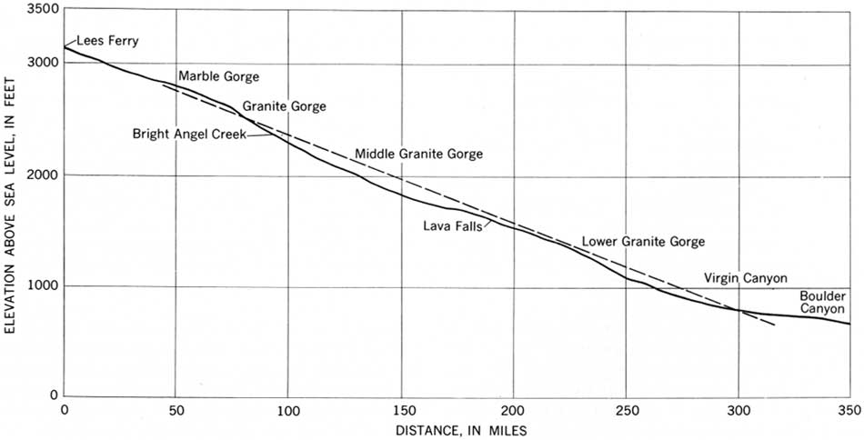
|
| FIGURE 97.—Longitudinal profile of the Colorado River through the Grand Canyon. A straight dashed line drawn at the average gradient shows that the river profile, though somewhat irregular, is nearly straight. (click on image for an enlargement in a new window) |
| <<< Previous | <<< Contents >>> | Next >>> |
pp/669/secd4b.htm
Last Updated: 22-Jun-2006