
|
Geological Survey Professional Paper 669
The Colorado River Region and John Wesley Powell |
RESPONSE OF A RIVER IN A ROCK CANYON
(continued)
Types of Waves and Causes of Rapids
In attempting to ascertain the causes of rapids, it would be helpful if one knew the details of the sizes and types of boulders or the configuration of bed rock making up the riverbed through the rapids. As only depth soundings are available, one must infer what he can about the bed from other evidence. The character of the shoreline and the distribution of wave forms at the water surface provide some indication of what is hidden under water. To aid in drawing inferences about the causes of rapids, it is useful to categorize the forms seen on the surface, especially the relation of waves to the shoreline and to what is known about water depth.
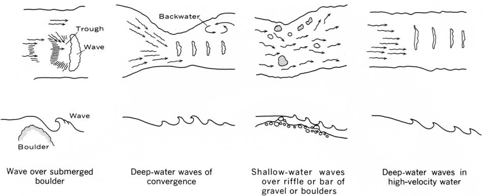
Four types of waves can be distinguished in rapids. This fourfold classification is descriptive of the hydraulic form rather than the geomorphic cause of the rapids. It is a classification based on the origin of large waves or wave trains in rapids rather than an explanation of why rapids occur at a given place in a canyon. Each type of wave is shown diagrammatically in figure 91.
|
| FIGURE 91.—Diagrams showing four types of water waves in rapids. Upper sketches show a plan view of the river; lower sketches indicate the inferred relation of waves to the bed configuration. (click on image for an enlargement in a new window) |
Waves below large rocks or outcrops.—A common cause of large waves is the chance occurrence of extremely large boulders or rock outcrops in the channel. These rock masses or blocks force water to pass over and around the obstruction. The water speeds up on the downstream side, causing a hole or deep trough in the water surface. Immediately below that, a standing wave occurs characterized by water leaping upward at the wave crest and continually breaking toward the upstream side.
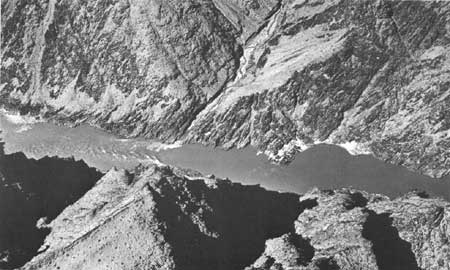
Deep-water waves caused by convergences.—Convergence seems to be the most common cause of wave trains consisting of individual waves of large magnitude. As shown in figure 91, a narrowing of the channel forces water from along the side of the channel toward the center, often simultaneously from both banks, resulting in a pileup of water near the channel centerline and a train of waves (fig. 92) having wavelengths and amplitudes dependent upon the amount of flow and the amount of convergence.
|
| FIGURE 92.—A rapid due primarily to convergence where rockbound channel narrows in a part of Granite Gorge. |
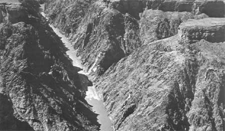
Waves and riffles in shallow water.—The ordinary riffle seen in small streams generally results from shallow water. Often the shallow water is caused by a gravel bar (fig. 93) and sometimes by a low-angle fan being deposited in the channel from an entering tributary (fig. 90). The form of the bar or channel obstruction, in large rivers as well as small, is a topographic hump on the streambed. There will usually be a deep pool immediately upstream, but over the obstructing bar the water will flow in a shallow and more or less uniform sheet at higher than usual velocities owing to the steep water slope on the downstream side of the obstructing bar.
|
| FIGURE 93.—Rapids unrelated to any tributary entrance and presumably caused by large gravel bar deposited on streambed. |
Waves in deep but high-velocity water.—When large waves occur in a rapid, it is usually not possible to tell whether the water is shallow or deep. We have enough measurements to show that large waves can occur even in very deep water, but not associated with convergence, as described above.
Categorizing the surface features of rapids, as suggested above, leads to the conclusion that the typical alternation of pools and fast water is not the result of random occurrence of rock outcrops in the channel, tributary fans, or talus falls from adjoining cliffs. These causes of rapids are relatively obvious, but only a few of the rapids in the Grand Canyon can be explained by these, as will now be shown.
A channel obstruction causing a rapid can be formed by large blocks of rock falling into the river from adjacent high cliffs. In many places along the Colorado, one sees bedrock blocks whose dimensions are in hundreds rather than tens of feet. Sometimes these are seen as great blocks protruding from the river, but more often, their size can be appreciated when they are on the river margin or on the slopes beneath the enclosing cliffs. The depth soundings through some rapids show that the depth changes instantly from very deep to very shallow and just as quickly increases again. This strongly suggests that the boat has just passed a large block of cliff rock which fell into the river and is completely submerged. Even some of the big rapids seem to be caused primarily from rockfalls from the cliffs. Many rapids are so far from adjoining cliffs, however, that this explanation is improbable.
The second obvious reason for rapids in the great canyons is the occurrence of a fan of rock debris debouched from an entering tributary and partly blocking the river. Many tributaries, however, do not cause a rapid at all, although they are apparently equal in size to those that do.
Some rapids must be the result of outcrops of especially hard rock locally, but because such outcrops are submerged, the cause must be inferred. Lava Falls, one of the largest and most dangerous rapids in the Grand Canyon, seems to be of this sort. In middle Pleistocene time, basalt from a lava eruption partly filled the canyon. This lava flow later was eroded away. Its occurrence suggests such a cause for this steep and violent rapid.
Many rapids, however, do not seem to be explained by the three types of circumstances mentioned. Rather, they are associated with what seems at first glance to be a random occurrence of gravel accumulations, either as a central bar across the channel or as the channelward extension of a lateral gravel bar. In fact, these gravel accumulations are not random when viewed in terms of a long reach of channel. They have a roughly regular spacing as has long been observed in the occurrence of gravel riffles in small streams. Some support for this inference comes from the data on the number of rapids per unit distance mentioned earlier. In the first 150 miles below Lees Ferry, a reach dominated by the sedimentary rock in Marble Canyon, rapids average 1.6 miles apart. In the next 178 miles downstream, a reach dominated by the metamorphic rock of Granite Gorge, the spacing also averages 1.6 miles. The above data refer only to spacing of steep zones in the profile. Spacing of bars or shallow places not observable at the surface. is a shorter distance.
Thus, the occurrence in canyon rivers of rapids separated by deeper pools, despite the seeming irregularity in any given locality, is apparently independent of the major bedrock type and the valley characteristics associated with different bedrock types. The alternation appears to be one aspect of channel adjustment toward maintaining stability or quasi-equilibrium and is typical in canyon rivers as well as in small streams on a wide and unconfined valley flat.
Another fact that suggests the existence of a quasi-equilibrium state is the long period of time that the Colorado River has maintained its present bed. It was mentioned above that in Pleistocene time, part of the canyon in the lower Granite Gorge was partly filled by the outpouring of lava. By using a radioactive-decay method, McKee, Hamblin, and Damon (1968) determined the age of lava cropping out near the present river level in the vicinity of Toroweap as 1.16 m.y. (million years). They stated (p. 133), "This represents a minimum age of Grand Canyon, for at the time the lava formed, the Canyon was essentially as deep as it is today. Since that time the Colorado River has cut through the 550-foot lava dam at the mouth of Toroweap Valley * * *" plus certain additional strata. These authors go on to say (p. 135), "The negligible amount of canyon deepening during the last million years or more can scarcely be attributed to the hardness of the rock * * *. Probably the most important factor involved in the apparently retarded downcutting, however, is the stream gradient which is controlled by elevation above sea level."
To explain in different words the importance of this age determination: the river has had a long time to smooth out breaks in gradient resulting from outcrops of hard rock and from tributary fans or big rockfalls. The erosion of more than 500 feet of hard basalt would require more time and the expenditure of more stream power than would be necessary to dispose of even the largest tributary fan or rockfall observed anywhere in the canyon. Accordingly, one finds it difficult to avoid the conclusion that the river profile is essentially graded and that the alternation of smooth pools and steep rapids is a natural habit of the river, related to the achievement of an equilibrium condition probably equatable to a tendency toward minimum work.
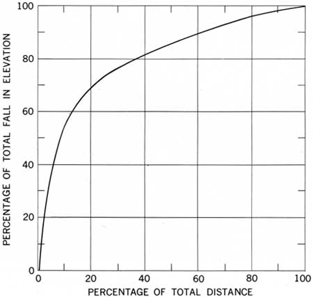
The rapids in the Grand Canyon constitute the most important element in the river's approach to sea level. Considering the whole length of the Grand Canyon, the decrease in elevation of the water flowing through all the pools is small compared with the decrease resulting from even a few of the principal rapids. Figure 94 is a graph showing the proportion of the total elevation attributable to various distances. It can be seen that 50 percent of the total decrease in elevation takes place in only 9 percent of the total river distance. In half the total river length, 86 percent of the total elevation decrease is achieved. The asymmetry of this curve demonstrates the importance of the rapids in accounting for a large proportion of the total elevation drop. For example, in those rapids that have a slope of .01 or more (1 foot drop in 100 feet), 28 percent of the total elevation drop is accounted for.
|
| FIGURE 94.—Relation between the fall in elevation of the Colorado River and distance along the channel in the first 150 miles of the Grand Canyon below Lees Ferry. |
The 10 largest rapids are listed below in order of decreasing water-surface gradient; these alone account for 19 percent of the total fall in the 150-mile river reach used as a sample.
List of steepest rapids, Lees Ferry to mile 150, Grand Canyon
| Slope in feet |
Length in miles | |
| House Rock Rapid | 0.0170 | 0.33 |
| Horn Creek Rapid | .0168 | .4 |
| 75-Mile Rapid | .0164 | .2 |
| Badger Creek Rapid | .0162 | .2 |
| Zoroaster Creek Rapid | .0150 | .2 |
| 76-Mile Rapid | .0130 | .3 |
| Unkar Rapid | .0130 | .4 |
| Tuna Creek Rapid | .0130 | .2 |
| Sockdologer Rapid | .0126 | .4 |
| Grapevine Rapid | .0120 | .7 |
| Total | 13.3 | |
| 1Or 2.2 percent of 150 miles. NOTE.—Total drop through 10 steepest rapids is 246 feet or 19.3 percent of total drop in 150 miles. | ||
The direction and speed of water through and below a rapid in the Grand Canyon illuminates some aspects of the bed form and profile. Commonly, immediately below a very steep rapid, a large part of the downstream flow will be thrown against one bank, particularly if that bank is a vertical cliff. When this occurs, the opposite side of the stream will invariably have a strong upstream current at the water surface, often forming half the total stream width. Between the downstream and upstream surface currents, then, a strong shear zone exists that will be characterized by boils or round domes of upwelling water. These boils are sporadic in size and intensity, as would be expected of turbulent eddies. The boils in the Grand Canyon may be as small as 3 feet in diameter or as large as 40 feet in diameter. The vertical component of upwelling water is distinctly shown by the dome-shaped topography of the water surface over the eddy. The amount of surface elevation or vertical superelevation of the water surface over the boil is a direct indication of the strength of the vertically directed upward current. We estimated that this vertical superelevation was as much as 1 foot, indicating a vertical velocity of 8 fps.
The presence of vertically directed water in the shear zone requires for continuity that there also be downward-directed motions. These seems to take the form of deep vortexes at the foot of the rapids, especially in the lee of large rocks that are partly submerged. Vortexes are also common in deep slow pools below rapids. The other source of downward vertical motion seems to be the diving of large amounts of water at the foot of a rapid; this water, because of the steep slope through the rapid, already has a downward component. The deep hole at the foot of many rapids, then, must represent scour by downwardly directed water, much of which must flow along the bed at high velocities downstream, later to appear broken into upwelling filaments that cause the described boils. Some indication of the intensity of the downward motion and the speed of water movement downstream at the bed is indicated by two types of observation.
On several occasions I put a fluorescein-dye marker in the river close to the shear zone at the foot of a large rapid. The bag enclosing the dye was buoyant, for it was the type designed for the use of pilots shot down at sea. In several of these trials, the dye bag immediately disappeared, and was dragged below the surface by the downward component. We circled in the pool for a considerable time, waiting to see where the dye marker would appear. In one instance it did not reach the surface again until it had been taken downstream nearly a quarter of a mile. The amount of time required for the marker to reappear provided an estimate of mean downstream velocity of the transporting filament, approximately 8 fps.
Current-meter velocity measurements in a reach just upstream of Unkar Rapid give another indication of the strength of the current near the bed. The cross sections and some velocity measurements are given in figure 95. Near the deepest part of cross section 3, where the depth was about 45 feet, the measured surface velocity was 11.4 fps, and an equal velocity was measured 1 foot above the bed.

|
| FIGURE 95.—Channel cross sections and sketch map, showing appearance of water surface near Unkar Rapid. Velocity measurements (fps) near the river surface and near the bed are shown for cross section 2. (click on image for an enlargement in a new window) |
It seems, then, that large amounts of water dive at the foot of a rapid to the bottom of the succeeding pool. Some of this water moves swiftly downstream near the bed, and filaments of it are projected to the surface in large boils having a high vertical velocity. This motion in the vertical plane is a part of another large-scale circulation in which most of the flow is confined to one-half of the river channel, whereas water in the other half of the channel is flowing upstream simultaneously at a velocity of as much as 10 or 12 fps. Such an eddy occurs downstream from the area shown in figure 95.
It is interesting that even the most experienced river boatmen greatly underestimate the depth of water in the Grand Canyon and the variability of depth. The extent of the downward and upward motions also was a surprise even to the most experienced.
One may well inquire whether the position and magnitude of the pools and the rapids change with time. Obviously, the period of observation of individual rapids is so short that an answer by direct observation is impossible. Certain inferences, however, may be drawn.
Those rapids caused by the accumulation of debris fans at the mouths of tributary canyons clearly cannot migrate away from the tributary mouth. Therefore, their position must be essentially fixed in geologic time.
A few rapids probably result from a sill or outcrop of especially hard rock upon which an overfall forms as the water cuts into less competent beds downstream. Lava Falls might well be attributed to such a cause, but no other major rapid. Therefore, the upstream migration of knickpoints caused initially by the occurrence of a local body of hard rock cannot account for the succession of rapids throughout the canyon length.
Rapids formed by local accumulation of large blocks falling directly into the river from adjacent cliffs would be expected to decrease in magnitude as these rocks gradually eroded away, but the position of such a rapid should not migrate upstream.
The great age of the lava that once dammed the river at Toroweap strengthens the conjecture that the river has had ample time to eliminate the sections having steep rapids. The rapids, therefore, must be relatively stable features.
| <<< Previous | <<< Contents >>> | Next >>> |
pp/669/secd4a.htm
Last Updated: 22-Jun-2006