
|
Geological Survey Professional Paper 715—B
Combined Ice and Water Balances of Maclure Glacier, California, South Cascade Glacier, Washington, and Wolverine and Gulkana Glaciers, Alaska, 1967 Hydrologic Year |
GULKANA GLACIER
DESCRIPTION
Gulkana Glacier (lat 63°15' N., long 145°28' W., fig 7) is a branched valley glacier on the south flank of the Alaska Range. The accumulation zone consists of four cirque glaciers which converge in a simple south-flowing ablation area. The mean ELA is about 1,700 m. The basin area is 31.6 km2 and is 70 percent covered with perennial snow and ice. Drainage from the glacier flows into first the Delta, then the Tanana, and finally the Yukon Rivers north of the Alaska Range.
|
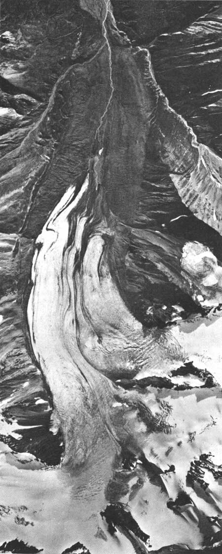
| FIGURE 7.—Vertical aerial photomosaic of Gulkana Glacier, Alaska Range, Alaska, August 31, 1967. The higher altitudes of the glacier are covered with late snow which fell several weeks earlier. (See pl. 4A.) |
FIELD PROGRAM
Streamflow measurements from Gulkana Glacier basin began September 16, 1966, at a gage installed 1.3 km downstream from the terminus of the glacier (site 1, pl. 4A). The winter flow recession was defined by discharge measurements (table 7), the early spring rise by discharge measurements and weather data, and the summer open-water flow by discharge measurements and a continuous record of the stream stage in the natural channel. A U.S. Weather Bureau 8-inch storage precipitation gage was installed at site 1.
TABLE 7.—Instrumentation at Gulkana Glacier basin during the 1967 hydrologic year
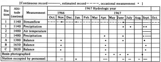
A large storage precipitation gage was installed on April 18, 1967, at 1,480-m altitude (site 2, pl. 4A) in the basin. Continuous recording of precipitation and air temperature began on September 3, 1967, and will appear in reports covering subsequent hydrologic years. Balance index station C (pl. 4A) was relocated at 2,020-m altitude in the eastern cirque of Gulkana Glacier.
Vertical photographs were taken on August 31, 1967, by Austin Post and were used to redefine the margin of Gulkana Glacier and other glaciers and perennial snow fields in the basin.
WEATHER
The weather recorded at a U.S. Weather Bureau station at Trims Camp (U.S. Dept. of Commerce, 1967-68), 23 km northwest of Gulkana Glacier, was near normal during the 1966-67 winter season but departed significantly from the previous 10 years of record during the summer of 1967. A series of strong storms in July and August 1967 produced heavy rainfall below 1,800-m altitude in mid-August culminating in widespread flooding in interior Alaska. At Trims Camp, the July precipitation was 161 percent of normal; August was 168 percent of normal. The July and August storms deposited heavy accumulations of wet snow above 1,800-m altitude on Gulkana Glacier (pl. 4D). Air temperatures measured at Trims Camp were near normal during the 1967 hydrologic year.
GLACIOLOGIC BALANCES
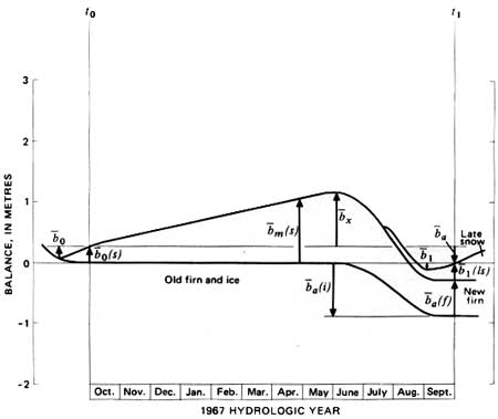
The 1967 hydrologic year at Gulkana Glacier began
with an average of 0.27 m water equivalent of snow,  0(s), already
accumulated on the 1966 summer surface (table 8, fig. 8). By April 27,
1967, the measured winter snow balance, m(s) (pl. 4B) averaged 1.05 m on the
glacier. The snow densities varied from 330 to 370 kg/m3 over
most of the basin, which is approximately twice the snow density found
in the lowlands of interior Alaska. Measurements at seven pits showed
that at any given altitude the snow density increased as a result of
depth or loading. At the same time, the snow density decreased with
altitude when comparing equal depths of snow. Temperatures at the base
of the snowpack ranged from -4° to -9°C and varied over the
glacier in a similar manner as the snow density; the 330 to 340
kg/m3 density snow was -8° to -9°C at its base
whereas the 360 to 370 kg/m3 density snow was -4° to
-6°C. The temperature data were used to compute the amount of snow
meltwater expected to refreeze during the spring in the underlying
permeable firn by assuming that all heat required to warm the firn to
0°C was provided by refreezing water. The calculated internal
accumulation ice averaged 0.02 m water equivalent over the glacier.
0(s), already
accumulated on the 1966 summer surface (table 8, fig. 8). By April 27,
1967, the measured winter snow balance, m(s) (pl. 4B) averaged 1.05 m on the
glacier. The snow densities varied from 330 to 370 kg/m3 over
most of the basin, which is approximately twice the snow density found
in the lowlands of interior Alaska. Measurements at seven pits showed
that at any given altitude the snow density increased as a result of
depth or loading. At the same time, the snow density decreased with
altitude when comparing equal depths of snow. Temperatures at the base
of the snowpack ranged from -4° to -9°C and varied over the
glacier in a similar manner as the snow density; the 330 to 340
kg/m3 density snow was -8° to -9°C at its base
whereas the 360 to 370 kg/m3 density snow was -4° to
-6°C. The temperature data were used to compute the amount of snow
meltwater expected to refreeze during the spring in the underlying
permeable firn by assuming that all heat required to warm the firn to
0°C was provided by refreezing water. The calculated internal
accumulation ice averaged 0.02 m water equivalent over the glacier.
TABLE 8.—Ice and water balances, Gulkana Glacier basin, 1967 hydrologic and balance years
[Values and errors in metres water equivalent expressed as averages over the glacier and basin except where indicated. Date: Hydrologic year, Oct. 1, 1966 (t0) through Sept. 30, 1967 (t1)]
| Glacier |
Basin |
Date | Term | Explanation | |||
| Value | Error | Value | Error | ||||
Yearly mass balances | |||||||
| a |
-0.30 | 0.14 | -0.24 | 0.13 | Hydrologic year | Annual balance | Total change in snow, firn, and ice storage during the 1967 hydrologic year, from t0 to t1; approximately equal to difference between precipitation as snow and melt-water runoff for the hydrologic year. |
| n |
-.20 | .15 | -.7 | .15 | Sept. 1, 1967 | Total mass net balance | Change in storage from the minimum balance in 1966 autumn (t0') to the minimum in the 1967 autumn (t1'). |
| a(fi) |
-.28 | .14 | -.23 | .13 | Hydrologic year | Annual firn and ice net balance | Change in firn and ice storage during the 1967 hydrologic year; excludes late summer snow on the basin.. |
Accumulation and ablation | |||||||
| m(s) |
1.05 | 0.12 | 0.89 | 0.10 | Apr. 27, 1967 | Measured winter snow balance | Snowpack on the 1966 summer melt surface (ss0); measured in late winter or spring in pits and by probing. |
| x |
.90 | .10 | .77 | .10 | June 4, 1967 | Maximum balance | Storage change from the beginning of the hydrologic year
(t0) to the maximum in the spring. Winter balance (bw)
equals maximum balance (x) plus the absolute
value of the initial balance increment (0). |
| a(f) |
.61 | .10 | .39 | .08 | Hydrologic year | Annual firnification | The increment of new firn in the accumulation area at t1, measured after melting from this residual snowpack (firn) ceases in the autumn. |
| a(i) |
-.89 | .11 | -.62 | .09 | do | Annual ice balance | Ice and old firn melt in the ablation area during the hydrologic year. |
 a a |
1.80 | .30 | 1.48 | .20 | do | Annual accumulation | Total accumulation of snow between t0 and t1. |
 a a |
2.10 | .33 | 1.72 | .25 | do | Annual ablation | Total ablation of snow, ice, and old firn between t0 and t1. Approximately equal to the difference between annual rainfall and runoff. |
Values relating annual and net ice balances | |||||||
| 0 |
0.20 | 0.07 | 0.16 | 0.07 | Sept. 1-30, 1966 | Initial balance increment | Storage change between time of minimum in 1966 autumn (t0') and beginning of hydrologic year (t0). |
| 0(s) |
.27 | .10 | .20 | .10 | Oct. 1, 1966 | Initial snow balance | Snow accumulated on the 1966 summer surface (ss0) at beginning of hydrologic year (t0); measured in pits and by probing. |
| i |
0 | .01 | 0 | .01 | do | Initial ice balance | Ice and old firn melt after t0 and before the winter snowpack covers the glacier; measured by ablation stakes. |
| 1 |
.10 | .05 | .09 | .05 | Sept. 1-30, 1967 | Final balance increment | Storage change between time of minimum in 1967 autumn and the end of the hydrologic year. |
| 1(ls) |
.25 | .05 | .19 | .05 | Sept. 30, 1967 | Final late snow balance | Snow accumulated on the 1967 summer surface (ss1) at t1. |
| 1i |
0 | .01 | 0 | .01 | Final ice balance | Ice and old firn melt after t1 and before the next year's snowpack covers the glacier. | |
Glacier and basin dimensions | |||||||
| S(fi) | 119.3 | 0.2 | 22.2 | 0.3 | Sept. 30, 1967 | Glacierized area | Glacier value includes firn and ice areas which normally are attached to the main trunk glacier. Basin value is the main glacier plus all other small glaciers and perennial snowfields in the drainage basin. Ice-cored moraine and other permafrost areas are not included as glacierized areas. |
| S | 119.3 | .2 | 31.6 | .3 | do | Total area | Glacier and water drainage basin above the stream gaging station. |
| AAR | 2.60 | .03 | .41 | .03 | do | Accumulation area ratio | Area of new firn, accumulation area, divided by the total area. An index of annual balance. |
| ELA | 1740 | 20 | do | Equilibrium line altitude | Average altitude where snow ablation equals snow accumulation. An index of annual balance. | ||
| δL | -50 | 20 | Hydrologic year | Advance or retreat | Average horizontal distance change of terminus of the glacier in direction of flow. | ||
Precipitation and runoff | |||||||
| pa* | 2.43 | .33 | 2.15 | 0.28 | Hydrologic year | Calculated annual | Area average annual snow and rain precipitation; the sum
of annual stream runoff and annual storage change
(a). |
 a a |
2.73 | .30 | 2.39 | .25 | do | Annual runoff | Stream discharge for the year divided by glacier or basin area, expressed as average depth of water over the area; measured by stream stage recorder and stream discharge measurements. |
1Square kilometres. 2Dimensionless. | |||||||
|
| FIGURE 8.—The balance of Gulkana Glacier, 1967 hydrologic year.(Refer to table 8 for additional values.) |
During the 1966-67 winter, an extensive stream icing (aufeis) formed from the glacier terminus to the stream gage covering an area of 0.4 km2 with 1 to 4 m of ice. At least 0.03 km2 of the icing, up to 1 m thick, remained at the end of the summer season (see fig. 7).
Snowmelt began in late May 1967 and the maximum
glacier balance, x (0.90 m), occurred about June 4, 1967.
Above 2,100-m altitude, the snowpack accumulated intermittently
throughout the summer and a summer surface formed in July during short
periods of melting. Near the glacier terminus, 5 to 6 m of combined
snowmelt and ice-melt was measured during the summer. Snowmelt equaled
accumulation at 1,740-m altitude. The severe July and August storms
brought hail and dense wet snow above 1,800-m altitude. Late snow
covered the entire glacier briefly on September 1, 1967, then covered
the basin completely on September 19, 1967, to end the melt season. The
late snow balance, i(ls), averaged 0.25-m water equivalent by
the end of the 1967 hydrologic year.
Approximately 60 percent of the snow measured on
April 27, 1967, m(s), remained as new firn and internal
accumulation, a(f), at the end of the melt season in
September 1967. Small patches of firn remained at 1,500-m altitude, but
the main accumulation area was above 1,700-m (pl. 4).
Ablation of glacier ice began in June 1967 near the
terminus where 5.4-m water equivalent of melting occurred. Melting was
continuous through the summer until September 1, 1967, and was then
intermittent until September 19, 1967, when the glacier became snow
covered. During August lateral erosion by Phelan Creek removed some
additional ice by calving. Approximately 46 percent more ice and old
firn melted in 1967 than new firn accumulated, so the annual firn and
ice balance, a(fi), of Gulkana Glacier was -0.28 m.
HYDROLOGIC BALANCE
The basin winter precipitation from October 1, 1967,
t0, to April 27, 1967, was approximately the measured
snow balance, m(s) (0.89 m), minus the initial snow
balance, 0(s) (0.20 m), as no rain runoff or melting
occurred during the period. The ratio of this calculated winter
precipitation (0.69 m) to the precipitation (0.66 m) measured at Trims
Camp weather station is 1.04:1. The annual precipitation for Gulkana
Glacier basin,  a* (2.15 m), was estimated as
the sum of the annual runoff, a (2.39 m), and the annual balance, a (-0.24 m).
Thus, the precipitation from April 27, 1967, to September 30, 1967,
t1, can be calculated (2.15-0.69=1.46 m). The
precipitation gage at 1,480-m altitude recorded 0.76 m of rain and snow,
and Trims Camp received 0.70 m during the same period. The windshield on
the precipitation gage in the glacier basin was damaged by high winds
during the storms. The wind deflection slats proved to be too light, so
the gage may have intercepted only part of the wind-driven snow and
rain. The ratio of the calculated Gulkana Basin precipitation (1.47 m)
to Trims Camp summer precipitation (0.70 m) is 2.1:1. The cumulative
precipitation, a* (pl. 4D) was derived
by applying the above ratio to daily precipitation measurements made at
Trims Camp. Because of large uncertainties in the correlation, the
estimated standard error of this analysis is ±0.3 m.
a* (2.15 m), was estimated as
the sum of the annual runoff, a (2.39 m), and the annual balance, a (-0.24 m).
Thus, the precipitation from April 27, 1967, to September 30, 1967,
t1, can be calculated (2.15-0.69=1.46 m). The
precipitation gage at 1,480-m altitude recorded 0.76 m of rain and snow,
and Trims Camp received 0.70 m during the same period. The windshield on
the precipitation gage in the glacier basin was damaged by high winds
during the storms. The wind deflection slats proved to be too light, so
the gage may have intercepted only part of the wind-driven snow and
rain. The ratio of the calculated Gulkana Basin precipitation (1.47 m)
to Trims Camp summer precipitation (0.70 m) is 2.1:1. The cumulative
precipitation, a* (pl. 4D) was derived
by applying the above ratio to daily precipitation measurements made at
Trims Camp. Because of large uncertainties in the correlation, the
estimated standard error of this analysis is ±0.3 m.
Part of the winter streamflow from Gulkana Glacier refroze in the valley bottom to form a large aufeis sheet. The remainder, 0.03 m3/s average over the winter, flowed past the stream-gaging station. The total winter runoff was surprisingly great considering the facts that no surface melting occurred in the winter, that no sedimentary rocks underlie the basin and that permafrost is present in part of the exposed bedrock. Only a thin veneer of ice contact deposits covers the valley floor. Even though very little ground water could be stored in the basin and part of the winter runoff refroze above the gage, there was 55 mm of runoff averaged over the basin from October 1, 1966 to May 20, 1967, the period of no surface melt runoff. It is estimated that only 1-5 mm of annual runoff could be caused by internal friction in the moving ice, and an additional 5 mm annual runoff due to geothermal heat flow melting the glacier sole. Approximately 50 mm of runoff during the winter must have come from ground water and water stored temporarily within the glacier, the major part of which is judged to be drainage of water from the glacier.
The August 8-17, flood-producing storm (Childers and others, 1972) brought approximately 315 mm of rain and wet snow averaged over Gulkana Glacier basin. This precipitation caused numerous mudflows on the ice-cored moraines adjacent to Gulkana Glacier and a peak stream flow discharge of 65 m3/s. A means of comparing flood peaks is to calculate the peak discharge per unit area of several basins. Gulkana Glacier basin produced approximately 2.1 m3s-1km-2. The four other basins with measured highest peak runoff during that storm include three in the Alaska Range; Birch Creek with 1.2 m3s-1km-2, Slime Creek, 1.1 m3s-km-2, and McCallum Creek, 0.7 m3s-1km-2; and one in the Yukon-Tanana upland, Idaho Creek with 1.3 m3s-1km-2. Gulkana Glacier basin has the highest average altitude, greatest relief, and largest glacier coverage of the five basins. These combined factors at Gulkana Glacier produced the highest measured runoff rate in August 1967.
The annual runoff from the glacier basin, a (2.39 m), was
the highest ever measured for interior Alaska. Snow melt contributed
1.10 m (46 percent) of the runoff, glacier ice melt, 0.62 m (26
percent), and rainfall, 0.67 m (28 percent). The ice loss from the
basin, a
(-0.24 m), was equal to 10 percent of the runoff.
| <<< Previous | <<< Contents >>> | Next >>> |
pp/715-B/sec5.htm
Last Updated: 28-Mar-2006