|
California Division of Mines and Geology
Bulletin 182 Geologic Guide to the Merced Canyon and Yosemite Valley, California |
ROAD LOG 1
U.S. HIGHWAY 50 FROM HAYWARD TO TRACY, CALIFORNIA*
By HOLLY C. WAGNER
U.S. Geological Survey, Menlo Park, California
and FREDERIC R. KELLEY
California Division of Mines and Geology
San Francisco, California
*Publication authorized by the Director, U.S. Geological Survey.
Between San Francisco and Hayward the field trip route follows U. S. Highway 50 across the Bay Bridge and turns onto the Nimitz Freeway (State Route 17), by-passing Oakland. As the Bay Bridge is crossed toward Yerba Buena Island, Alcatraz Island may be seen about 3 miles to the left, past the San Francisco waterfront. The buildings of the Federal Penitentiary are built on sandstone referred to the Franciscan formation and similar to the sandstone passed through at the entrance to the tunnel on Yerba Buena Island. This sandstone also serves as the anchorage foundation for cables suspending the western part of the Bay Bridge. From the east side of Yerba Buena Island, the Berkeley Hills can be seen on the skyline ahead. Jurassic, Cretaceous, and Tertiary rocks, which have been complexly folded and faulted, underlie the Berkeley Hills. The nearly straight west-facing front of the hills generally coincides with the Hayward fault zone, the locus of several earthquake epicenters in historic time. The route traverses the bay-margin flats to the Tracy turnoff (19.6 mi. from the west abutment of the Bay Bridge) where it leaves the Nimitz Freeway and turns eastward.
|
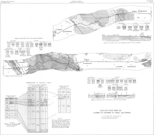
| Plate 2, Guide map to Highway 50, Hayward to Tracy, California, accompanies this road log. (click on image for a PDF version) |
| Mileage | |||
| 0.0 | Directly beneath the first overhead east of the Nimitz Freeway (Foothill Blvd. overhead—about 2.1 mi. east of the Nimitz Freeway) where the route rejoins U. S. Highway 50. This point is in the Hayward 7-1/2' quadrangle, about 1-1/2 miles east of the west border (see pl. 2). The Hayward fault zone, whose west limit was crossed about 0.2 mi. back, is about one-fourth mile wide in this area; the east limit of the fault zone crosses U. S. 50 just beyond this set of overheads but is not visible. | ||
| 0.1 | The gray exposure in the roadcut on the left is east of the Hayward fault zone and is largely mafic igneous rock, probably of Jurassic age (Ji on pl. 2). Much of the igneous rock is coarse-grained and locally appears to be composed entirely of saussuritized feldspar; altered pyroxenes are common in small areas. The exposed rock is intensely sheared, and serpentine marks many of the shear surfaces. The outcrop may be a multiple intrusion, and the several fine-grained "glassy" pods and zones that crosscut the body may represent selvages along the borders of separate small intrusives. The brownish zone at the top of the exposure reflects the depth of weathering. | ||
| 0.3 | Hill with eucalyptus trees to left is capped by Pleistocene Leona rhyolite (Q1 on pl. 2). Arenaceous shales of the Upper Jurassic Knoxville formation are here brought in contact with the mafic igneous rocks by the West Chabot fault, which is older than, and does not offset, the capping rhyolite. | ||
| 0.5 | Brownish outcrops to right are shales of the upper part of the Knoxville formation (Jku). The sequence consists of nearly vertical thin beds of weakly metamorphosed shale and sandstone. The beds average about 1 inch in thickness and are locally sheared and brecciated. They are well bedded and have interlaminations of silicified (?) siltstone. Low hill to left is underlain by Lower (?) Cretaceous Oakland conglomerate. The alluvium-covered trace of the East Chabot fault, which separates the Oakland conglomerate from the Chico formation, is crossed about one-half mile to the east (pl. 2). | ||
| 2.0 | Gravels are exposed in lower parts of roadcuts to left and directly under, and just beyond the Castro Valley Boulevard overhead. These gravels have been dated Pleistocene on the basis of vertebrate fossils found to the north. | ||
| 2.3 | Leaving Castro Valley. Fairly good exposures of steeply dipping sandstone beds of the Lower (?) and Upper Cretaceous Chico formation (Kc) can be seen in roadcuts for the next few miles. | ||
| 4.1 | Steeply dipping beds of dark-bluish (brownish-weathering) shale of the Chico formation on left. | ||
| 4.6 | Thin-bedded, gray (brownish-weathering), nearly vertical sequence of shale and siltstone in roadcut on left is in fault contact with massive grayish-brown sandstone near east end of cut. This fault is the northern extension of the Stonybrook fault mapped by Hall (1958) in the adjacent Dublin quadrangle. It has been revealed here by new road cuts made since Robinson (1956) mapped the Hayward quadrangle. Folding in Tertiary rocks shown on plate 2 just beyond this point is not visible from highway. | ||
| 4.9 | Massive, grayish-brown sandstone in contact with thin-bedded, brownish-weathering sequence of sandstone and siltstone in large roadcut on left. Weathering has emphasized shearing and crenulations in the thin-bedded sequence in upper part of exposure. Difference in attitude of beds in west half of cut suggests fault. | ||
| 6.0 | Entering Dublin 7-1/2 minute quadrangle (pl. 2). Terminology in this quadrangle is somewhat different from that in the Hayward quadrangle. Cross section B-B' on plate 2 depicts structure one-half mile ahead. | ||
| 6.5 | Exposure of middle Miocene Sobranre sandstone (Monterey group) in roadcuts to left. Lower Cretaceous Niles Canyon formation of Hall (1958) underlies hills to right. | ||
| 7.3 | Summit. Middle Miocene Oursan sandstone (Tmo) exposed on roadcuts. Outcrop on skyline about one-fourth mile to left is hard conglomeratic sandstone of the middle member of the upper Miocene Briones sandstone (Tmbm). One-half mile to the east this conglomeratic sandstone caps prominent ridge to left of highway, and at end of ridge the strike swings northwest around the axis of a northwest-plunging syncline. | ||
| 8.1-8.3 | Small outcrops of the lower sandstone member of the Briones (Tmbl) in roadcuts to left and right. | ||
| 8.4 | Dublin fault crosses road. Exposures poor. | ||
| 8.7 | Middle (conglomeratic) member of Briones (Tmbm) visible on hilltop to left. Lower (sandstone) member of Briones (Tmbl) in roadcuts. | ||
| 9.0 | The Livermore Valley may be seen stretching ahead. This valley is apparently a structural depression. On the west the valley has been downdropped along the Calaveras-Sunol fault; it may also have been downdropped along several northwest-trending faults that extend into the valley from the east, under the alluvial cover. Drilling for oil and gas has shown the presence of faults below the surface and a measure of the relative downward movement is supplied by the thickness of 8,000 to 10,000 feet of conglomerate of the Pliocene Orinda formation indicated by Hall (1958, pl. 2). | ||
| 9.6 | Passing under Foothill Road (State Hwy. 21) overhead. Calaveras-Sunol fault crosses road at this point but is concealed by alluvium. Cross section C-C' is 0.1 mi. ahead (pl. 2). | ||
| 10.1 | Mount Diablo (elev. 3,849') can be seen on skyline to left. This mountain was a guiding landmark in early Spanish days, and since 1851 has been the point of origin for land surveys of a large part of northern California and Nevada. On its south flank are steeply dipping Cretaceous and Tertiary beds; its core is composed of Jurassic rocks of the Franciscan formation. On the northeast side the Cretaceous and Tertiary sequence contains coal beds and white sands of economic interest in rocks of Eocene age. | ||
| 10.9 | Pastel-painted buildings to left are housing for Camp Parks, U. S. Army. | ||
| 12.4 | Alameda County Rehabilitation Center on left. To the right in the middle distance are stockpiles of processed gravel recovered from the alluvial deposits of Arroyo del Valle and Arroyo Mocho southwest of Livermore. Much of the gravel used in the Bay area comes from large gravel pits in this vicinity. | ||
| 12.9 | Entering the Livermore 7-1/2 minute quadrangle. | ||
| 13.5 | Low hills on left are underlain by nonmarine conglomerate and sandstone of the Pliocene Orinda formation. One and one-half miles ahead Hall's map (1958) shows dips of 80°-85° in these beds; some are overturned. | ||
| 16.5 | Crossing Hall's cross section F-F' (pl. 2). | ||
| 19.8 | Entering the Altamont 7-1/2 minute quadrangle. Livermore gravels of Clark, 1930 in low hills on both sides of road. | ||
| 20.5 | Livermore road junction. Lawrence Radiation Laboratory, a division of the University of California, about two miles to right. The Livermore facility was established in July 1952 and covers more than 600 acres. The program at the Laboratory (1961) includes investigations concerning physics and engineering of fission and thermonuclear devices; nuclear ram-jet propulsion (Project Pluto); critical assembly and reactor research; controlled release of thermonuclear energy (Project Sherwood); basic nuclear-particle research with various types of accelerators; and industrial applications of nuclear explosives (Project Plowshare). | ||
| 23.0 | Crossing over Western Pacific and Southern Pacific railroads. First roadcut on right exposes sandstone and some thin pebbly sandstone beds of the Cierbo formation. The Greenville fault crosses the road just beyond this roadcut (pl. 2) but is not exposed. | ||
| 23.2 | Roadcuts for next 3 miles expose westward-dipping beds of sandstone and shale of the Panoche formation of Late Cretaceous age. The unconformity with the overlying upper Miocene Cierbo is poorly shown. | ||
| 25.2 | Summit of Coast Ranges, here only about 1,040 feet in elevation. | ||
| 26.2 | Good exposure of west-dipping well-bedded shale of the Panoche formation on right. | ||
| 26.5 | Approximate axis of the Altamont anticline. Ahead the beds dip to the east. | ||
| 27.2 | Passing under Western Pacific Railroad overhead. Mileage checkpoint. | ||
| 27.5 | Entering the Midway 7-1/2 minute quadrangle. | ||
| 28.4 | Small fault cuts sandstone and shale beds of the Panoche formation in roadcut no left. Beds to east of fault dip more steeply than those to west. | ||
| 28.7-29.0 | Excellent exposures of sandstone and shale of the Panoche formation. | ||
| 29.1 | On hillslopes to right can be seen discontinuous outcrops of several hard beds of sandstone of the Panoche formation. Hill to left of road in near distance is capped by the hard basal conglomerate of the upper Miocene Neroly formation (Tnss). These beds unconformably overlie the Panoche formation (see cross section A-A', pl. 2). | ||
| |||
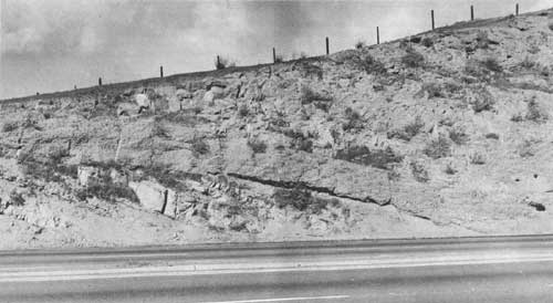
| 29.5 | STOP 1. Byron Turnoff. Because of freeway traffic we
wish to stop the buses off the main road where the exit road turns
off. Passengers REMAIN IN BUS: geology is pointed out through bus
windows. Buses will then go 1,000 feet ahead to a small side exit, turn
around, and return to the freeway. Unconformity between Neroly formation (upper Miocene) and Panoche formation (Upper Cretaceous). The sandstones and shales of the Panoche formation strike about N. 20° W. and dip about 20° NE. The sandstone beds are generally yellowish gray, 1-1/2 to 4 feet thick, and locally show prominent cross bedding and convolute bedding. The sandstones are medium-to coarse-grained, and are made up predominantly of subangular to rounded, fairly well-sorted quartz grains. Feldspar, biotite, chlorite, and dark grains are present but not abundant. The shale beds of the Panoche are thin (1/8" to 2"), are light gray to yellowish orange, and are slightly silty and carbonaceous. Thin (1/2") sandstone beds are commonly intercalated. The moderately fissile finely micaceous shale is predominantly clay and is closely jointed, breaking to small rhomboid fragments. The Panoche is overlain unconformably by conglomerate of the Neroly formation which lies upon the truncated edges of the sandstone and shale at an angle of about 15°. No weathered or humic zone occurs at the top of the Panoche, and the surface is grooved in a N. 25° E. direction. The grooves are filled with conglomerate in which the pebbles range in size from 1/2" to 3" but average 1" to 1-1/2". All pebbles are well rounded and are mostly volcanic rocks of andesitic composition held in a matrix of medium- to coarse-grained sandstone. Lenticular stringers of sandstone occur in the upper part of this basal conglomerate, which grades upward into the overlying sandstone. The sandstone is medium gray and is essentially a medium- to coarse-grained lithic wacke containing quartz and many dark grains. It is about 30 feet thick and is locally cross bedded. The sandstone unit lenses eastward to about 10 feet in thickness, and an overlying pebble-conglomerate unit nearly merges with the basal pebble-conglomerate bed. The upper conglomerate is locally cemented and breaks across the pebbles. Generally, however, the pebbles weather out in relief from the matrix. Locally the sandstone has a distinct purplish-blue cast. | ||
| 29.7 | Midway fault crosses road and repeats conglomerate at the base of the Neroly formation on east side of valley. Cross section A-A' crosses road at this point (pl. 2). | ||
| 29.9 | Upper (shale) member of the Neroly formation (Tnsh). | ||
| 31.1 | Roadcut on left shows lake clays in sharp contact with sands and gravels (mapped as Tulare formation of Pliocene and Pleistocene (?) age by Reiche, 1950, p. 4). Gravels contain subangular to rounded pebbles of finely veined brownish-red chert, white quartz, reddish-brown volcanic porphyry, and several varieties of greenstone. Crossbedded sands are interbedded with the gravel, but the lake beds, above, are nearly horizontal. | ||
| 31.5 | Delta-Mendota Canal, a major water transportation facility in the northern part of the San Joaquin Valley. This canal carries water from the delta area of the Sacramento and San Joaquin Rivers southward to supply the west side of the San Joaquin Valley with irrigation water. At the main pump station, which is 4 miles north of here; the water is lifted about 150 feet and flows southward nearly 120 miles to Mendota. The grade of the canal is about 3 inches per mile and near the south end regional subsidence of land has changed the grade and created flowage problems. Subsidence has amounted to about 10 feet since 1937 and in the area of maximum depression along the canal, about 15 miles northwest of Mendota, is about 1/2-foot per year. The subsidence is apparently a result of withdrawal of deep groundwater. | ||
| 32.7 | San Joaquin Valley ahead. Coast Range-Diablo Range runs southeastward to the right. Mt. Oso is the highest prominence in the hills to the right and forms part of the Franciscan core of the Diablo Range. Several manganese deposits occur in the vicinity of Mt. Oso in the Ladd-Buckeye area. The principal producer has been the Ladd mine, which began operations in 1867. Intermittent production to 1950 totalled an estimated 30,000 to 50,000 tons of manganese ore. The manganese occurs as gray rhodochrosite and bementite in massive white chert lenses in rocks of the Franciscan formation. Eight miles beyond Mt. Oso is the Red Mountain magnesite district, which yielded approximately 870,000 tons of magnesite between 1905 and 1945. The magnesite occurs as replacements of serpentine in shear zones in a large ultramafic intrusive body. | ||
| 34.0 | Town of Tracy ahead. At the northeast edge of town is the Tracy Gas Field. This field was the first commercial gas field found in northern California and the first California field to produce gas commercially from Cretaceous strata. The discovery well was completed in August 1935 and produced from the Tracy gas sand in the Panoche formation at a depth of about 4,000 feet. Maximum annual production from the field was more than 3 trillion cubic feet in 1936. The field is currently (1961) "shut-in". | ||
| 34.4 | Leaving strip-map area (east boundary of Midway 7-1/2 minute quadrangle). | ||
| 38.8 | Tracy High School. | ||
| 41.6 | Leave Highway U.S. 50. Turn right on State Highway 33 toward Vernalis and Patterson. The McMullin Ranch field, a new discovery, lies about 6 miles due east of this point. The discovery well was completed May 4, 1960 at 5,925-5,945 feet in sands of Late Cretaceous age. As of this writing (February 1961) active development is in progress. The Vernalis gas field lies east of Highway 33 about 7 miles ahead. This field was discovered in January 1941, and first commercial gas deliveries began in May 1942. The gas is produced from as many as 10 zones between 3,000 and 5,000 feet depth. For further information see Manlove's article on the Vernalis gas field in Bulletin 181. A fourth producing area nearby, called the Vernalis-Southwest field, lies about 5 miles southwest of the Vernalis field. The discovery well was completed in August 1959 with production from Upper Cretaceous sands at 4,560 feet. Payne (1962, pl. 17), shows correlations of the subsurface units in the Tracy and Vernalis gas fields with well sections farther to the south. | ||
References
Clark, B. L., 1930, Tectonics of the Coast Ranges of middle California: Geol. Soc. America Bull., v. 41, p. 747-828.
Hall, C. A. Jr., 1958, Geology and paleontology of the Pleasanton area, Alameda and Contra Costa Counties, California: Univ. California Pub. Geol. Sci., v. 34, no. 1, 89 p.
Huey, A. S., 1948, Geology of the Tesla quadrangle, California: California Div. Mines Bull. 140, 75 p.
Jenkins, Olaf P., ed., 1951, Geologic guidebook of the San Francisco Bay Counties . . . : California Div. Mines Bull. 154, 392 p.
Payne, M. B., 1962, Type Panoche group (Upper Cretaceous) and overlying Moreno and Tertiary strata on the west side of the San Joaquin Valley: California Div. Mines and Geology Bull. 181, pp. 165-175.
Reiche, Parry, 1950, Geology of part of the Delta-Mendota Canal near Tracy, California: California Div. Mines Special Rept. 2, 12 p.
Robinson, G. D., 1956, Geology of the Hayward quadrangle, California: U. S. Geol. Survey Geol. Quad. Map GQ-88.
| <<< Previous | <<< Contents >>> | Next >>> |
state/ca/cdmg-bul-182/sec5.htm
Last Updated: 03-Aug-2009