|
California Division of Mines and Geology
Bulletin 182 Geologic Guide to the Merced Canyon and Yosemite Valley, California |
ROAD LOG 3
EL PORTAL TO WAWONA TUNNEL AND A CIRCUIT OF YOSEMITE VALLEY, CALIFORNIA*
By DALLAS L. PECK
U.S. Geological Survey, Menlo Park, California
CLYDE WAHRHAFTIG
University of California, Berkeley, California, and
U.S. Geological Survey, Menlo Park, California
and FRANK C. CALKINS
U.S. Geological Survey, Menlo Park, California
*Publication authorized by the Director, U.S. Geological Survey.
EL PORTAL TO THE EAST PORTAL OF THE WAWONA TUNNEL
|
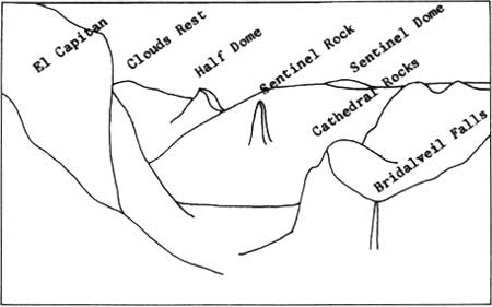
| FIGURE 1. Some of the features seen from the east portal of Wawona Tunnel. |

|
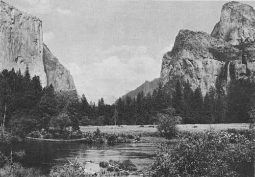
| FIGURE 2. Sketch map of the Yosemite Valley area, California. (click on image for a PDF version) |
| Mileage | |||||||
| 0 | El Portal (Standard Oil Company Service Station). The contact between the Calaveras formation (late Paleozic) and the granitic rocks of the Yosemite area trends due north a few hundred feet east of here. The marginal intrusive rocks include coarse diorite and some norite. Farther east is the V-shaped gorge of the Merced River, which, although glaciated during two pre-Wisconsin stages when the glaciers extended about one mile below here, was not glaciated during the Wisconsin. El Portal was formerly the terminus of the Yosemite Valley Railroad. For reference see the sketch map of the Yosemite Valley area (fig. 2), the generalized geologic map (Calkins and Peck herein, fig. 1), and the glacial map (Wahrhaftig, herein, fig. 5). | ||||||
| 3.5 | Arch Rock Entrance Station, National Park Service. | ||||||
| 3.6 | Arch Rock. Two large fallen blocks are in contact
at the top but are separated at the bottom by enough space for passage
of the old road. Talus of Arch Rock granite† is exposed in a quarry on
the north side of the road. The granite contains sparse inclusions of an
unidentified darker-gray rock similar in appearance to the granodiorite
at the Gateway.
| ||||||
| 4.7 | Elephant Rock is straight ahead. | ||||||
| 6.0 | Junction with the Coulterville Road, the first road into Yosemite Valley (completed as a toll road on June 17, 1874). | ||||||
| 6.2 | Wildcat Creek. El Capitan granite is exposed at the falls just west of here. | ||||||
| 6.5 | Cascade Creek. El Capitan granite (probably Cretaceous) is exposed in a nearby cliff, and some large fallen blocks of it can be seen from the road. | ||||||
| 8.4 | Junction with the Big Oak Flat Road. The original road, which lies farther up the slope, was completed one month after the Coulterville Road. At the road junction are exposures and talus of the older diorite (described as "diorite of the Rockslides" by Calkins and Peck). Here the diorite contains light-colored aggregates consisting mainly of plagioclase that probably formed as the result of metamorphism by the nearby El Capitan granite. | ||||||
| 9.4 | Turn right across Pohono Bridge. | ||||||
| 10.4 | Turn right on Wawona Road. | ||||||
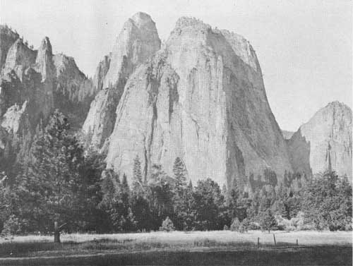
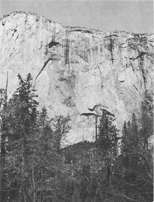
| 12.2 | Stop in parking lot at the east portal of Wawona Tunnel. View to the east of El Capitan, Sentinel Rock, Cathedral Rocks, the hanging valley of Bridalveil Creek, and Bridalveil Fall (fig. 1). Nearby exposures of various granitic rocks and of diorite. | ||||||
| |||||||
|
The abundance of joints in the diorite in the opposite valley wall (directly north of here) contrasts strongly with their scarcity in the massive cliffs of El Capitan and the Cathedral Rocks (composed mostly of El Capitan, Bridalveil, and Taft granites, all probably of Cretaceous age). The construction in the valley between El Capitan and the Cathedral Rocks may be due to the massive nature of the granitic rocks at this point. The great abundance of talus in the cliffs directly north of here, in contrast to the paucity of talus farther up the valley, is due to the close jointing of the diorite of the cliffs. The U-shape of Yosemite Valley, in contrast to the V-shape of the gorge of the Merced below El Portal, is well displayed here. The bottom of the U, however, is much flatter than in typical glaciated valleys. According to Gutenberg, Buwalda, and Sharp (1956, pl. 5), the bedrock surface lies almost 1,000 feet beneath the floor of the valley between El Capitan and Cathedral Rocks, and what we see is essentially a plain floored by lake sediments. The top of the highest glacier in Yosemite Valley, according to Matthes (1930), reached about to the brow of El Capitan, and was about 300 feet above the top of the Cathedral Rocks. The glacier swept around the flank of Sentinel Dome, but did not cover the dome. The upper 700 feet of Half Dome, likewise, was unglaciated. These domes owe their form to concentric spalling of massive unjointed rock, not to glacial erosion. The steep lower course of Bridalveil Creek above Bridalveil Fall is graded to the level established by the Merced River during the most recent of three distinct stages of preglacial erosion (from oldest to youngest, the Broad Valley, Mountain Valley, and Canyon stages of Matthes, 1930, p. 45-50); hence it helps to define the amount of glacial erosion in Yosemite Valley. The V-shaped form of the gorge of the creek, although typical of stream erosion, is preserved because the sloping walls of the gorge coincide with throughgoing joints in the otherwise nearly unjointed rock. The upper part of Fireplace Creek, a little downstream from us on the opposite wall, is graded to the Mountain Valley stage of the Merced Canyon. Ribbon Creek, above the head of Ribbon Fall (which cannot be seen from here, but can be seen on the north wall of the canyon from places a mile or two down the road), is graded to the Broad Valley stage of the Merced (see Wahrhaftig, herein, fig. 4). The blasted rock face at the west end of the parking lot exposes a complicated mixture of diorite and El Capitan granite. The porphyritic phase of the Taft granite is well exposed on the slope just to the west. El Capitan granite along the south side of the road contains blocks of partially assimilated diorite, and has a steeply dipping foliation. Turn around and drive east along the south side of the Valley, across Sentinel Bridge and to the Ahwahnee Hotel. | |||||||
CIRCUIT OF YOSEMITE VALLEY
| 0 | Ahwahnee Hotel. The route is plotted on the sketch map of the Yosemite Valley area (fig. 2). | ||||||||
| 0.3 | Entrance to Ahwahnee Hotel, turn right. | ||||||||
| 0.5 | STOP 1. Church Bowl. View across valley of Glacier Point. In the cliff face west of Glacier Point, note the contrast between unjointed Half Dome quartz monzonite (probably Cretaceous) below, and jointed granodiorite above. In the center of the valley south of here as much as 2,000 feet of glacio-lacustrine debris overlies the bedrock (Gutenberg, Buwalda, and Sharp, 1956; see Wahrhaftig, herein, fig. 5). In talus and in cliff faces on the north side of the valley at this stop dark-colored Sentinel granodiorite is cut by gently dipping light-colored dikes of coarse pegmatite and Half Dome quartz monzonite at the margin of the large body of Half Dome quartz monzonite. In some of the dikes of quartz monzonite unequal concentration of dark minerals produces a nearly horizontal layering. | ||||||||
| 0.7 | STOP 2. Parking lot at Yosemite National Park Headquarters. Visit to Museum. | ||||||||
| 1.7 | View of Sentinel Rock across valley. Along the cascade of Sentinel Creek to the right (west) of the rock, can be seen recesses caused by spalling of the granitic rocks around the cascade. Enlargement of the recesses appears to be developing vertical waterfalls from this sloping cascade. | ||||||||
| 3.0 | View of El Capitan straight ahead. | ||||||||
| |||||||||
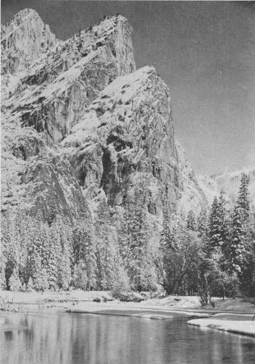
| 3.9 | Junction at north end of El Capitan Bridge: continue straight ahead. Brief stop for view, across valley, of Cathedral Rocks, Cathedral Spires, and Taft Point. On the faces of North and Middle Cathedral Rocks can be seen nearly horizontal light-colored dikes of Bridalveil granite cutting a maze of other granitic and dioritic rocks. | ||||||||
| 4.6 | STOP 3. (At V-7 sign.) The low ridge to the left is the easternmost of a series of Wisconsin terminal moraines which held in the former Lake Yosemite. The lake was filled with as much as 300 feet of silt and sand deposited on advancing deltas by the Merced River and Tenaya Creek; this debris was possibly supplied by glaciers of Tioga age, which reached only as far downstream as the lip of Nevada Fall and the upper part of Tenaya Canyon (see Wahrhaftig, herein, fig. 5). Walk south along the old road at the east side of the moraine to the Merced River, a distance of about 800 feet. In the moraine at the river are exposed boulders of Cathedral Peak granite, Half Dome quartz monzonite, Sentinel granodiorite (probably Cretaceous), and Bridalveil granite. The nearest exposure of Cathedral Peak granite is 12 miles east of here. Return to the main road and continue west. | ||||||||
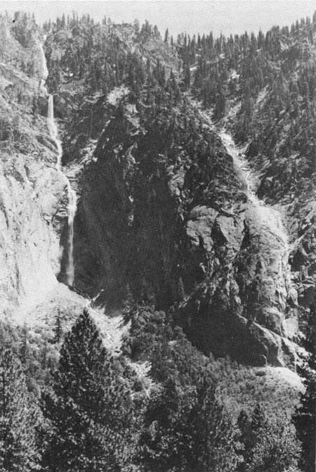
| 4.9 | Turnout. Brief stop for view of Bridalveil Fall, Leaning Tower, and Cathedral Rocks across valley. | ||||||||
| 5.8 | Valley View turnout. Brief stop for view of El Capitan, Clouds Rest, and Sentinel Rock to the east and Cathedral Rocks and Bridalveil Fall to the southeast. The western most of the Wisconsin terminal moraines lies a few hundred feet west of here. | ||||||||
| 6.0 | Turn left across Pohono Bridge. | ||||||||
| 6.5 | View of Rockslides across valley. | ||||||||
| 6.7 | Road again crosses the westernmost Wisconsin moraine. | ||||||||
| 7.0 | Junction with Wawona Road; turn right. | ||||||||
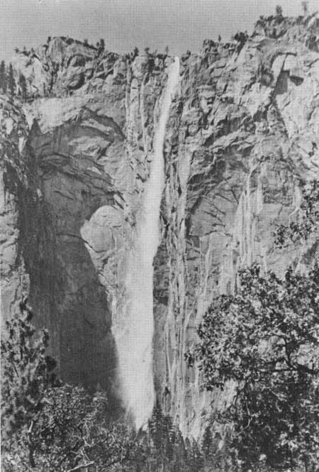
| 7.1 | STOP 4. Turn left into parking lot. Walk along trail
(about 1,000 feet) to viewpoint at base of Bridalveil Fall. Near
viewpoint are fallen blocks of Leaning Tower quartz monzonite (probably
Cretaceous), Bridalveil granite, diorite, and El Capitan granite. On
the cliff face at the lip of Bridalveil Fall can be seen a thick horizontal
sheet of smooth-weathering Bridalveil granite. Underneath is reddish
rough-weathering Leaning Tower quartz monzonite, and to the east is dark
diorite. Note that the lower part of Bridalveil Fall is in a slight
recess flanked by buttresses. The borders of the recess are marked by
the edges of slabs parallel to the surface, apparently the original
continuations of these slabs across the face of the fall have dropped from
the cliff and are represented by the cone of talus extending up the
cliff to an apex just west of the base of the fall. Looking across the valley to the recess in which Ribbon Fall lies, one can see similar spalling in the upper part of this recess. Return to parking lot and drive east along the south side of the valley past the turnoff to Pohono Bridge. Bank on south side of road exposes bouldery terminal moraine. | ||||||||
| 7.9 | Road crosses the moraine examined at Stop 3. | ||||||||
| 8.4 | View of El Capitan across valley. | ||||||||
| 8.8 | Junction with road to El Capitan Bridge. View of Sentinel Rock to the east, directly up the road. The forms of Sentinel Rock, Glacier Point, the north face of Half Dome, etc., are controlled by vertical joints trending east to northeast. | ||||||||
| 9.0 | Brief stop at V-33 sign for view of El Capitan and Three Brothers across the valley. On the face of El Capitan the irregular boundaries of an intrusive body of diorite form a crude map of North America. This cuts an inconspicuous westward-sloping dike of gray rock, probably Leaning Tower quartz monzonite. The form of the Three Brothers is controlled by joints dipping obliquely westward. | ||||||||
| |||||||||
| 10.6 | View of Yosemite Falls across the valley. | ||||||||
| 11.1 | Road junction at south end of Sentinel Bridge. Continue east, not crossing bridge. South of here are remnants of the Old Village, the center of commercial activity in the valley between the late 1850's and 1917. | ||||||||
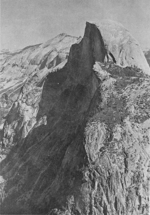
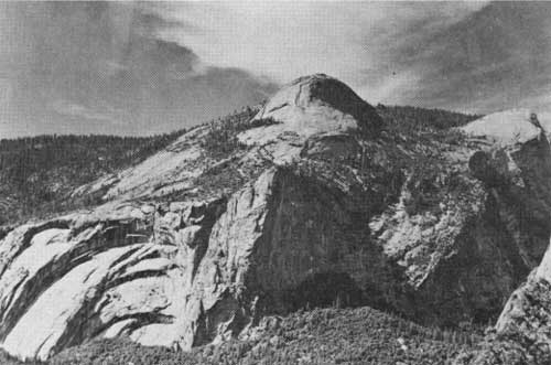
| 11.2 | Brief stop for a view to the east of North Dome, Half Dome, Royal Arches, Washington Column, and Glacier Point. The form of the Royal Arches, Half Dome, and North Dome is controlled by exfoliation of the Half Dome quartz monzonite, resulting from expansion due to unloading brought about by denudation. | ||||||||
| 11.5 | Road junction; continue straight ahead. | ||||||||
| 12.2 | Road crosses Happy Isles Bridge. | ||||||||
| 12.7 | Road crosses Wisconsin moraine. View of North Dome straight ahead. | ||||||||
| 12.8 | Road junction; bear right. | ||||||||
| 13.1 | Road junction; bear right. | ||||||||
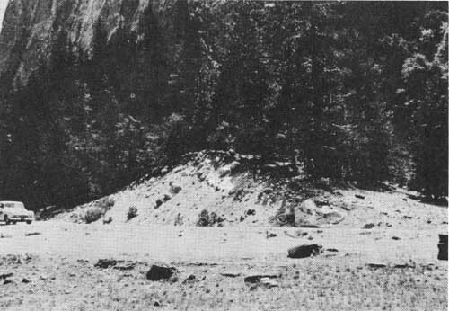
| 13.5 | Road crosses rock avalanche that dammed Tenaya Creek, forming Mirror Lake. | ||||||||
| |||||||||
| 13.8 | STOP 5. Parking lot at Mirror Lake. View of Mirror
Lake, and of Tenaya Canyon to the east. Walk along trail to the
northeast about 1,000 feet to see glacial polish and striae on Half Dome
quartz monzonite. Note well-formed books of biotite in this rock. Return to parking lot and drive west. | ||||||||
| 14.5 | Road junction; bear right. | ||||||||
| 14.7 | "Indian Cave," north of road, is in coarse talus at the foot of the cliff. | ||||||||
| 14.9 | View ahead of sheeting in the Royal Arches, formed by exfoliation. | ||||||||
| 15.3 | Sugar Pine Bridge. | ||||||||
| 15.7 | Road junction; bear right. | ||||||||
| 15.8 | View ahead of flat-lying dikes of Half Dome quartz monzonite and pegmatite in Sentinel granodiorite. | ||||||||
| 15.9 | Entrance to Ahwahnee Hotel; turn right. | ||||||||
| 16.2 | Ahwahnee Hotel. | ||||||||
References
Gutenberg, Beno, Buwalda, J. P., and Sharp, R. P., 1956, Seismic explorations of the floor of Yosemite Valley, California: Geol. Soc. America Bull., v. 67, p. 1051-1078.
Matthes, F. E., 1930, Geologic history of Yosemite Valley: U. S. Geol. Survey Prof. Paper 160, 137 p.
| <<< Previous | <<< Contents >>> |
state/ca/cdmg-bul-182/sec7.htm
Last Updated: 03-Aug-2009