|
Texas Bureau of Economic Geology
Padre Island National Seashore: A Guide to the Geology, Natural Environments, and History of a Texas Barrier Island |
THE DYNAMIC BARRIER ISLAND
(continued)
HUMAN INTERACTION WITH THE DYNAMIC BARRIER ISLAND
When people occupy a barrier island, either temporarily or permanently, they become involved in the natural dynamic processes that operate on the island. The interaction between people and the island works two ways: human activities affect the environments and natural processes, and the environments and natural processes affect people and their activities. Often this interaction is not harmonious, particularly in the more dynamic environments along the Gulf shoreline. An example of human impact on barrier islands occurs when someone builds a structure along a beach that is eroding. This is a common trend along much of the Texas Gulf Coast. When shoreline erosion threatens a structure, an attempt must be made to control the erosion or abandon the structure. To control erosion and to protect investments, groins or seawalls may be constructed, but often with far-reaching consequences. Groins, for instance, extending perpendicularly to the shoreline into the surf zone, are designed to interrupt longshore sediment transport and trap sediment along the upcurrent side of the groin, causing the beach to accrete (grow seaward). Property owners immediately upcurrent are happy that their beach is restored and their property saved, for the time being. Unfortunately, their downcurrent neighbors are unhappy with this temporary, localized solution, because they begin to lose their beach by erosion at an accelerated rate. The sand supply transported by littoral drift that helped to maintain their beach has been cut off by the groin.
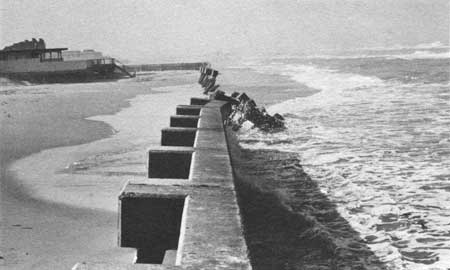
Seawalls also pose complications because the beach in front of the walls and in adjacent areas along the shore will continue to erode. Seawalls interfere with the equilibrium of processes affecting beach and foredune environments. For example, where fore-island dunes are present, the dunes provide natural protection against storm surge by helping to dissipate wave and current energy. They also act as natural sand "reservoirs" that help to replenish the beach during wave attack. This natural interplay is lost when dunes are leveled and cemented behind a seawall. Accordingly, the capability of the natural system to recover and maintain itself under erosional conditions, or under wave attack during hurricanes, is greatly diminished. As the shoreline retreats, the waves will eventually break directly on the seawall; an expensive maintenance program will have to be initiated to reestablish and maintain the beach in front of the seawall or to maintain the seawall itself (fig. 64). Once the beach has disappeared, a valuable property asset and a major point of attraction has been lost.
|
| Figure 64. Seawall on south Padre Island, south of the National Seashore. Portions of the seawall have collapsed as a result of frequent attack by daily wave and tidal activity and as a result of less frequent but more intensive assault by very high tides accompanying tropical storms and hurricanes. Note the absence of a usable beach in front of the seawall. |
Because the National Park Service's recreational development plans are to maintain most of the island in a natural condition, many conflicts between natural processes and human activity that occur elsewhere along the Gulf Coast should not occur along the National Seashore. For instance, structures placed too near an erosional shoreline are not a problem along the National Seashore. Littoral drift convergence, which occurs along central Padre Island, helps to balance sediment supply and demand; this reduces the amount of erosion that takes place and adds stability to much of the beach along Padre Island.
Some human activities far removed from Padre Island can affect environments of the National Seashore. This was demonstrated in the summer of 1979 when an oil well being drilled offshore from Mexico, approximately 500 miles southeast of the Rio Grande, blew out and for several months released thousands of barrels of oil a day into Gulf waters. Currents transported the oil northward where it eventually reached the Texas shoreline and beaches. A massive effort was undertaken by the U.S. Coast Guard, scientists, environmentalists, and others to clean oil off beaches and to prevent it from entering tidal passes and the biologically sensitive and productive environments of Laguna Madre and other bays and estuaries to the north. Scientists estimated that even after the well was brought under control, oil already released would continue to arrive along the Texas shoreline for months. In the fall of 1979, the seasonal southward shift in longshore currents provided relief to the Texas coast. At this time, the effect of the oil on the National Seashore, its environments, and associated plants and animals is unknown and may prove difficult to assess.
Linking Gulf and Lagoon Waters
Mansfield Channel and accompanying jetties are one example of how people have interacted with and locally modified natural conditions along Padre Island. Mansfield Channel (South Section, pl. I), which was dredged across Padre Island, connects Port Mansfield directly to the Gulf and serves commercial and recreational fishing boats that operate out of the port. This connection with the Gulf locally moderates the salinity of Laguna Madre, which normally has a much higher salinity than the Gulf. Fish are able to migrate in and out of the lagoon via the channel. Jetties constructed mostly of granite blocks extend the channel a short distance into the Gulf. The jetties help maintain flow within the channel.
Jetties constructed of precast concrete tetrapods were emplaced in 1957 directly upon existing bottom sediments "without a stone blanket to distribute the load and prevent erosion" (Hansen, 1960). The north and south jetties were 1,600 feet and 900 feet long, respectively, and generally were elevated about 5 feet above mean low sea level. Within a few months after completion, both jetties had undergone extensive subsidence; the gulfward end of the north jetty was 3.5 to 7 feet below the water's surface (Hansen, 1960). The effectiveness of the jetties was greatly reduced, and shoaling occurred rapidly in the channel seaward from the original shoreline.
The present jetties were designed using modern engineering techniques and have consequently been more effective. They were engineered to be impermeable to longshore drift, to undergo a minimum of subsidence and erosion, and to take advantage of natural tidal and wind-tidal currents that help to scour sediments and prevent shoaling of the channel mouth. The jetties have caused localized changes in the Gulf shoreline by interrupting longshore sediment transport. Deposition of sediments has occurred on the upcurrent side of the jetties, and erosion has occurred on the downcurrent side (figs. 13 and 24).
Yarborough Pass is another example of human interaction with natural processes along the National Seashore. The channel was dredged to provide an exchange between Gulf and lagoon waters to reduce the high salinities in north-central Laguna Madre. The pass, which did not have jetties, was initially dredged in April 1941, but remained open for only 5 months (Breuer, 1957). Its closure was a result of natural processes — primarily deposition resulting from longshore sediment transport. The pass was reopened by dredging in November 1942, May 1944, and November 1944, but each time, it closed in a few months. Breuer (1957) reported that during "the four years of dredging, the pass remained open for a period of 10 months, and reasonable flow was maintained for only 6 months." Gunter (1945) observed that while the pass was open, salinity in Laguna Madre was altered only about 0.5 percent and that was localized to within 0.5 mile of the pass. In February 1952, the Texas Game and Fish Commission reopened Yarborough Pass. The channel was dredged 60 feet wide; 3 weeks later it was only 3 feet wide (Simmons, 1957). Since then no attempts have been made to reopen it. Although the channel has been closed to the Gulf, boats can be launched on the lagoonward side of the island, where the channel still provides access to the intracoastal Waterway (Central Section, pl. I). The fate of Yarborough Pass is an example of how efforts to modify the Gulf shoreline are sometimes thwarted by natural processes that work to reclaim and restore the island to its former conditions.
Effects of People on the Beach and Fore-Island Area
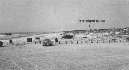
Vehicular traffic on the beach is another human activity along the National Seashore that creates changes. Comparing beaches where vehicular traffic is permitted with those where it is prohibited, one can easily see the difference (fig. 65; see Field Trip Road Log, Observation Point 2, fig. 114). On beaches where traffic is prohibited, vegetation on the backbeach encroaches much closer to the Gulf shoreline, where it traps windblown sand and forms small coppice mounds (small dunes stabilized by clumps of vegetation) and wind-shadow dunes. In areas where vehicular traffic is permitted, the vegetation cannot survive long enough to trap and accumulate sand, so the backbeach is much smoother, flatter, and broader than in the nonvehicular areas.
|
| Figure 65. Northern end of pedestrian beach, along which vehicular traffic is not allowed. View is southwestward. Vegetation, which traps sand blown from the beach, grows much closer to the shoreline in areas where it is protected from the constant impact of vehicular traffic (also see fig. 114). Photograph was taken before Hurricane Allen (August 1980) destroyed the low vegetated dunes. With time, dunes will be reestablished. |
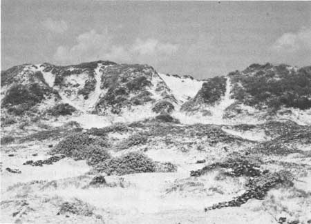
Pedestrian traffic has also affected vegetation. In areas where Seashore visitors regularly hike up the fore-island dune ridge to get a better view of the island, deep trails have developed in the dune ridge because the vegetation is unable to tolerate the constant trampling (fig. 66). The ease with which the vegetation is destroyed by pedestrian traffic reflects the fragile relationship between the vegetation and underlying loose sand in this semiarid climatic region.
|
| Figure 66. Trails worn in fore-island dunes by pedestrians. View is westward. In areas where vegetation is trampled and destroyed by excessive traffic, the loose sand is exposed to the action of the wind, which may erode the previously vegetation-stabilized areas and form active blowout dunes that migrate lagoonward, thereby covering and smothering other areas of vegetation. |
Where vegetation is destroyed, particularly along the fore-island dune ridges, the erosional forces of both wind and water are more effective. Unvegetated fore-island dune ridges are much more susceptible to breaching by storm tidal surge than are well-vegetated ridges. In turn, surge might engulf and destroy adjacent areas of vegetation and initiate a cycle of wind erosion that gains momentum in the form of migrating and expanding dune fields.
Creation of Experimental Dunes
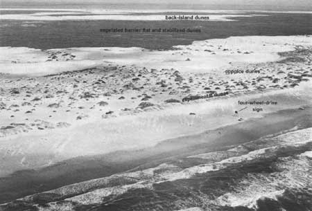
Because well-stabilized fore-island dunes are instrumental in protecting the island and mainland against storms, attempts have been made to artificially initiate dune formation and stabilization along areas that lack continuous dune ridges. From 1969 to 1974, an experimental project was conducted by B. E. Dahl and others (1974) to test the capability of various beach grasses to grow and stabilize fore-island dunes along two segments of Padre Island. The northern test segment was located along the National Seashore approximately 5 miles south of Malaquite Beach (North Section, pl. I; fig. 67). Several plant species, including both exotic and indigenous (native) species, were tested to select the ideal plants and planting techniques for dune formation and stabilization. Two grasses — sea oats (fig. 35a) and bitter panicum (fig. 35f), both indigenous to the island — were selected as having the most ideal attributes of the species tested. Bitter panicum was the more desirable of the two.
|
| Figure 67. Experimental fore-island dune ridge. View is toward the northwest. The dune ridge that lies parallel to and along the back edge of this beach was formed by vegetation that was planted to trap and accumulate the sand blown from the beach by onshore winds. This particular dune ridge, one of a series that was artificially established, is located in the area of the four-wheel-drive sign, which is visible in the photograph (see pl. I, grid K-4, for location of sign). Note the streaks of dry, white sand that have formed downwind from clumps of vegetation on the backbeach. These accumulations of sand show effects of the onshore winds that were blowing when the photograph was taken. Also note that sand piles up along the dune ridge, but where there are gaps in the ridge, sand migrates into the interior of the island. |
The success of the experimental plantings and the subsequent establishment of a continuous fore-island dune ridge illustrates that a process occurring naturally along the Gulf shoreline can be accelerated. Dahl and others (1974) noted that the "artificial process can create in just a few years what probably takes 10 to 20 or more years to occur naturally."
Human Reaction to Windblown Sand
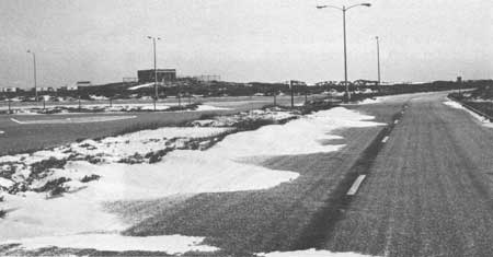
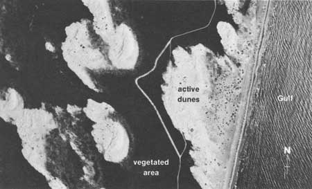
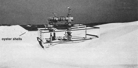
The effects of the blowing sand and human response to it are apparent in many areas of the National Seashore, including the Malaquite Beach area, where bulldozers are frequently used to scrape sand from the parking lot (fig. 68) and paved roads (fig. 69). Some back-island roads have been rerouted around mobile dune fields to reduce the constant maintenance required to keep the roads clear (compare figs. 48 and 70). Relocation of some facilities is not possible, however, and a continuing maintenance program must be employed (fig. 71).

|
| Figure 68. Bulldozer scraping windblown sand off the paved parking lot at Malaquite Beach. View is gulfward. |
|
| Figure 69. Tongues of sand blown by onshore winds onto a road near Malaquite Beach. Gulf is to the left. |
|
| Figure 70. Road rerouted because of migrating dunes. Note the old road has been engulfed by active dunes that are migrating across the island. Gulf is to the right. Compare this figure (photograph taken in 1975) with figure 48 (photograph taken in 1974 before the new road was constructed). |
|
| Figure 71. Natural gas wellhead threatened by burial under windblown sand. Attempts to stabilize the sand include the use of a covering of oystershells, which can be seen in the background to the left of the well. View is eastward to the Gulf of Mexico. |
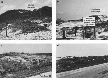
Various techniques have been used to control migrating sand. These preventive measures include planting vegetation and erecting fences and signs to discourage pedestrian traffic and prohibit vehicular traffic in vegetated areas (figs. 72a and 72b). Oystershells and native grasses (which have been cut and baled) are occasionally spread over barren sand to inhibit its movement (figs. 72c and 72d). Many of the attempts to stabilize sand have been partly successful, but total success requires the cooperative effort of all Seashore visitors to protect the wide variety of native plants that offer natural stability to the dunes.
| <<< Previous | <<< Contents >>> | Next >>> |
state/tx/1980-17/sec3d.htm
Last Updated: 28-Mar-2007
