|
Texas Bureau of Economic Geology
Padre Island National Seashore: A Guide to the Geology, Natural Environments, and History of a Texas Barrier Island |
ENVIRONMENTS OF PADRE ISLAND AND LAGUNA MADRE
The active processes of the wind, waves, and currents on the barrier island and in the adjacent lagoon have created and continue to shape the natural environments. Each of the environments that presently compose the barrier and lagoon systems has a unique set of physical and biological characteristics. These distinguishing characteristics are related to sediment texture and composition, sedimentary structures, density and types of vegetation, topography, position on the island and in the lagoon, size, areal configuration, relation to other environments and to sea level, and the types of processes affecting the environment. Following is a description of the natural environments and man-made or man-modified features as mapped on plate I.
BARRIER SYSTEM
The environments composing the barrier system are the beach, sandflat and/or coppice dune fields, fore-island dune ridge, barrier flats, stabilized blowout dunes, washover channels, wind-deflation flats, ponds and marshes occupying wind-deflation troughs, back-island dune fields, fore-island blowout dunes, and back-island sandflats. These terrestrial environments are affected by storms, the day-to-day forces of the wind, waves, and longshore currents, and biological activity. Except for part of the beach, the barrier environments are never flooded by astronomical or average wind tides but only by storm surge and, in certain places, by abnormally high wind tides.
Beach (B1)*
*Map unit symbol used on plate I.
Of all island environments, the beach is perhaps the most familiar to Seashore visitors. But the Padre Island beach certainly is not just one long stretch of shoreline with uniform conditions. A journey from north to south along the beach will show the visitor marked differences in the amount of shell material, the kinds of shells, and the beach profile and width.
Most of the sediment composing Padre beaches is classed as fine sand, which coarsens slightly from north to south (Hayes, 1965). The sand consists primarily of quartz, but it also contains subordinate amounts of feldspar, rock fragments, and heavy minerals, such as hornblende, pyroxene, garnet, staurolite, rutile, zircon, and tourmaline (Bullard, 1942). In addition to land-derived sediments, shells and shell fragments make up varying percentages of the total beach sediment.
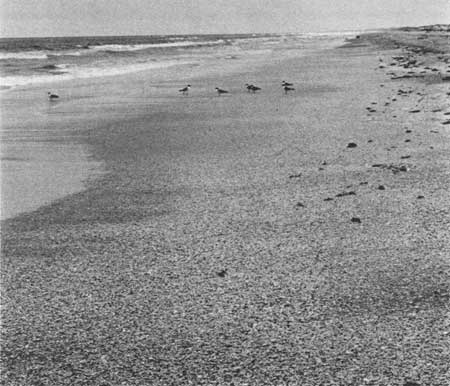
The highest concentrations of shell (up to 80 percent of the total sediment) are found on the beaches of central Padre (fig. 73), where converging longshore currents concentrate shell and sand. Winds carry the sand landward, leaving the shell behind on the beach (Watson, 1972). Little Shell Beach, so named for the abundance of shells of the small clam Donax (fig. 25), occupies a stretch of shoreline immediately north of Yarborough Pass. The maximum shell accumulation on Little Shell Beach occurs between the four-wheel-drive warning sign and Yarborough Pass (pl. I). The shells on Big Shell Beach (fig. 26) south of Yarborough Pass are characterized by the large clams Noetia (Eontia) ponderosa Say, Mercenaria campechiensis Gmelin, and Echinochama arcinella Linne (Watson, 1972). The zone of densest shell accumulation on Big Shell Beach occurs 30 to 40 miles north of Mansfield Channel (Watson, 1972), or approximately 5 to 15 miles south of Yarborough Pass (pl. I). In addition to those shells that are characteristic of particular beaches, several species of the clam Anadara are fairly common on all of Padre's shell beaches.
|
| Figure 73. Shell beach. This shell beach lies within a zone where longshore currents converge, concentrating sand and shell. Much of the fine sand is carried landward by the wind, leaving the shells behind on the beach. View is to the south. |
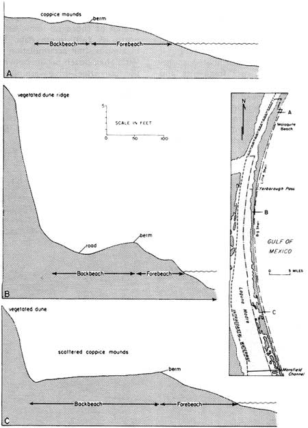
The beach environment lies between the submerged upper shoreface (breaker and surf zones) and the fore-island dunes. The beach can be divided into two zones — the forebeach and the backbeach (fig. 74). The forebeach slopes seaward and is subject to the daily swash of waves. The backbeach, which includes a berm normally constructed and affected during spring and storm tides, is separated from the forebeach by the berm crest. Generally, the backbeach is either horizontal or gently landward-sloping, creating a shallow trough between the berm crest and fore-island dunes.
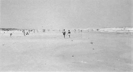
Obvious variations in beach profiles occur along Padre Island within the National Seashore (fig. 75). North Padre beaches such as at Malaquite (fig. 76) are relatively flat with a very low berm, if any. Because of differences in shoreline processes and sediment types and availability, the beaches of central Padre are characterized by steeper forebeaches and higher berms, in some places accentuated by erosion (fig. 30). Generally where sediments are coarser, as on the shell beaches, a higher berm will be maintained.
|
| Figure 76. Malaquite Beach, typical of north Padre beaches, having a flat profile and broad, shallow cusps. View is to the north. |
The top of the berm is the site of a very large accumulation of flotsam and jetsam, especially south of the maintained beach at Malaquite. Many of the bottles, boards, trees, shoes, rope, coconuts, and other things that make Padre a beachcomber's paradise have washed ashore after drifting hundreds or thousands of miles across the ocean. In addition to man-made materials, lumps of beach tar are concentrated on top of the berm. There are several ideas about the origin of tarballs, but most probably the asphaltic material is derived from a variety of sources, including natural sources such as offshore oil seeps, as well as industrial activities. Human effect on the quantity of beach tar was dramatically illustrated by the results of a large oil spill from a blown-out well in the Gulf of Mexico in 1979, described in the section on Human Interaction with the Dynamic Barrier Island (see p. 42). Some of the spilled oil reached Padre beaches in the form of sticky tarballs.
Beach cusps are locally pronounced on Padre Island. Size and shape of the cusps vary from one segment of beach to another, as well as along any given beach when wave conditions change. Figure 76 shows broad, flat, and widely spaced cusps on Malaquite Beach; much more prominent and closely spaced cusps on a central Padre shell beach are shown in figure 34. Refer to the discussion of beach cusps in the section on the Dynamic Barrier Island (p. 24) for a more detailed discussion of these interesting features.
Anyone who has camped overnight on the beach or who has gone out to the beach early in the morning might have observed small white creatures scurrying over the sand and suddenly disappearing. These are ghost crabs (Ocypode quadrata), which live in burrows in the backbeach and upper part of the forebeach. Primary inhabitants of the forebeach include the mud or ghost shrimp (Callianassa islagrande), snails (Olivella and Terebra), and the clam Donax, which hurriedly burrows into the beach sediment after the backwash of each wave. Other animals living in the beach environment are various species of polychaete worms and mole crabs (Lepidopa and Emerita). The beach is relatively barren of plant life, although spreading vines of goatfoot morning-glory (Ipomoea pescaprae, fig. 35b), sea purslane (Sesuvium portulacastrum, fig. 35c), and fiddleleaf morning-glory (Ipomoea stolonifera, fig. 35d) are among the salt-spray-tolerant plants that occupy the backbeach.
On aerial photographs, the beach appears as a narrow, barren band (200 to 300 feet wide) that stretches down the gulfward edge of Padre Island. For purposes of environmental geologic mapping (pl. I), the beach is defined as the area between the low tide line and either the fore-island dune ridge (B3) or coppice dune fields (B2). Small coppice dunes that develop around vegetation clumps seaward of the dune ridge are actually part of the backbeach environment. However, where coppice dunes are large and numerous landward of the forebeach and can be easily distinguished on aerial photographs, they are mapped separately as the sandflat and/or coppice dune field unit (B2) on plate I.
Sandflat and/or Coppice Dune Field (B2)
Sandflats with or without coppice dunes have been mapped in fore-island areas immediately landward of the beach and in back-island areas at the edges of large dune fields (pl. I). Where there is no vegetation, the sand can be spread out by wind and water to create a sandflat. If vegetation is present, however, the blowing sand will collect around the vegetation clumps to produce mounds of sand called coppice dunes. Wind-shadow dunes commonly form by accumulation of sand in protected areas (wind shadows) downwind of coppice dunes.
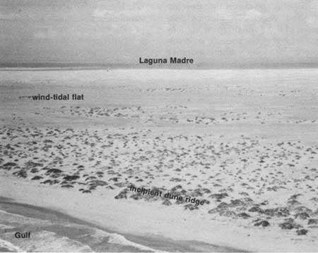
The most accessible coppice dune fields lie between the beach and the fore-island dune ridge (fig. 77). These fields are narrow bands paralleling the beach along miles of Padre's shoreline. In the southern part of the National Seashore (pl. I), where the dune ridge is absent or present as only short segments, broader coppice dune fields extend landward from the beach and occupy a large part of the island (fig. 78).

|
| Figure 77. Coppice dune field lying between the beach (left) and the fore-island dune ridge (right). The coppice dunes occupy what is usually considered the backbeach, but they have been mapped on plate I as a separate environment. These coppice mounds, which develop in and around vegetation clumps, are no more than 1 to 2 feet high, although in other areas they may be 6 feet or higher. |
|
| Figure 78. Broad coppice dune fields in the southern part of the National Seashore near Mansfield Channel. The largest dunes are those nearest the beach; they appear to be joining to form a fore-island dune ridge. View is to the southwest. |
The sediment composing the coppice dunes is the fine beach sand that has been blown landward and has collected in backbeach vegetation clumps and in the wind shadows behind them. Coppice mounds normally remain small (less than 3 feet high), but they may grow to 6 or more feet in height if the vegetation on which they build remains healthy and is not destroyed by storm waves or by man. The larger coppice dunes may merge and become part of the fore-island dune ridge (B3). Some coppice dune fields mapped on plate I are actually beginning to form a dune ridge (fig. 78).
Other, less accessible coppice dune fields fringe back-island dune fields. Many of these back-island coppice dunes form around sparse vegetation that has become established on sandflats where other larger dunes have been destroyed by storm waters or wind. In some places, coppice and wind-shadow dunes may develop from the erosional remnants of older dunes that have been partly stabilized by vegetation.
Fore-Island Dune Ridge (B3)
Immediately landward of the backbeach or coppice dune fields and parallel to the shoreline is a row of high, grass-covered dunes called the fore-island dune ridge. In the northern and central parts of the Seashore (pl. I), the dune ridge is fairly continuous and reaches its maximum height. When viewed from the Gulf side, as from the surf zone in figure 79, the fore-island dunes appear to be a high wall of sand and vegetation, an island barricade that protects the barrier flat from the full force of hurricanes and other storms. In the southern part of the Seashore, however, the ridge is either absent or broken into low, discontinuous, sparsely vegetated dunes providing little or no protection against storm winds, waves, and tides.

|
| Figure 79. Fore-island dune ridge of central Padre Island, as viewed from the surf zone. The dune ridge, which protects the island from storm winds, waves, and tides, reaches its maximum heights and is most continuous on central Padre. In the southern part of the Seashore, however, the ridge is low and segmented or is absent altogether. |
The fore-island dunes consist of fine, very well-sorted sand that has been blown from the beach and stabilized by vegetation. In addition, fairly coarse pieces of shell are carried onto the foredunes by strong onshore winds. Although the size of the dunes is partly determined by the amount of sand available to form them, vegetation is necessary to keep the sand from blowing farther inland. The fact that the drier and more sparsely vegetated southern part of the Seashore (fig. 37) lacks well-developed foredunes demonstrates the importance of vegetation. The sparse vegetation will not prevent the sand from blowing onto the sandflats. The low ridges formed by merging coppice dunes are easily breached by storm attack. In the northern half of the Seashore, the denser vegetation traps sand and results in high foredunes. Maximum elevations along the dune ridge in that area may exceed 50 feet, but elevations generally range from about 20 to 40 feet.
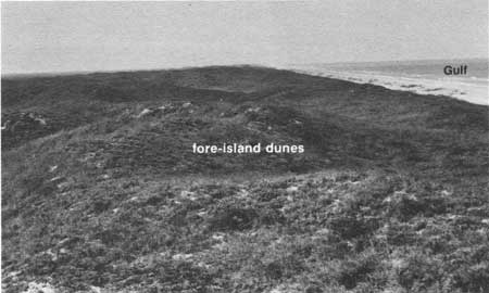
Width, as well as height, of the fore-island dune ridge is not uniform along the island. Generally, the ridge is about 200 to 300 feet wide. However, in some areas (for example, grids P-11 through U-11 on pl. I) where the foredune sand was once blown out a short distance landward and later restabilized (fig. 80), the dune ridge appears wider (up to 1,200 feet across). Where stabilized blowout dunes are continuous with the dune ridge, they were mapped with the fore-island dune ridge (B3) on plate I rather than mapped separately as stabilized blowout dunes (B6).
|
| Figure 80. Fore-island dune ridge at one of its widest points (pl. I, grid R-11). At places such as this, sand was at one time blown out landward from a narrower dune ridge and then restabilized with vegetation. Because there is no well-defined topographic break between these restabilized blowout dunes and the foredunes, the restabilized dunes were mapped on plate I together with the foredunes as part of the fore-island dune ridge (B3). View is to the north. |
Types of plants constituting the important vegetative cover (fig. 35) of the ridge are generally zoned according to elevation on the dunes. Marshhay cordgrass (Spartina patens), morning-glory (Ipomoea spp.), and sea purslane (Sesuvium portulacastrum) are common on the lower parts of the dunes. Middle and upper parts of the dunes support sea oats (Uniola paniculata), bitter panicum (Panicum amarum), and gulf croton (Croton punctatus). Seacoast bluestem (Andropogon scoparius littoralis) is a grass limited to the more protected and better vegetated back sides of the foredunes (Brown and others, 1976).
Vegetated Barrier Flat (B4, B5)
Behind the fore-island dune ridge lie vast barrier flats vegetated by various types of grasses and small shrubs (fig. 81). The flats slope very gently lagoonward from an elevation of about 5 feet behind the dune ridge to sea level at the lagoon shoreline. Breaking the uniformity of the flats are linear and curved ridges of stabilized blowout dunes (B6) and smaller isolated stabilized dunes that are mapped with the barrier-flat environment. Several active blowout dunes (B10) are currently migrating landward across the barrier flat, smothering and destroying vegetation as they move toward the back side of the island.

|
| Figure 81. Heavily vegetated barrier flat supporting various grasses and small shrubs (pl. I, grid T-4). The grass-covered dunes in the distance are part of the fore-island dune ridge. View is eastward from Park Road 22 toward the Gulf. |
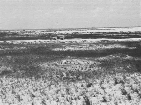
Most barrier flats at one time were barren wind-deflation flats or sandflats. The more sparsely vegetated barrier flats (B5) are simply areas where the grasses have recently been established and have not had enough time or moisture to develop a dense cover (fig. 82). Plate I shows that most sparsely vegetated barrier flats occur on the southeast, or windward, edge of migrating dune fields. These areas were recently wind eroded and have supplied sand to the active dunes. In time, most of the sparsely vegetated flats will evolve into the more heavily vegetated flats (B4), depending on the amount of rainfall. In the southern part of the Seashore near Mansfield Channel, wind-deflation flats remain barren because of lower annual rainfall and a higher rate of evaporation.
|
| Figure 82. Sparsely vegetated barrier flat (pl. I, grid T-3). This flat was previously a wind-deflation flat, or wind-eroded barren area, that had supplied sand to the active dune fields visible in the distance. Grasses are now being reestablished on this barrier flat. The flat can be seen along the Bird Island Basin road near Observation Point 6 of the Field Trip described at the end of this guide. View is to the northwest. |
Local ponds and marshes occupy low, depressed areas, commonly linear wind-deflation troughs (see discussion of B8) left behind by migrating back-island dune fields and blowout dunes (B10). Larger ponds and marshes were mapped separately on plate I as unit B9. There are more water bodies in the north and central parts of the Seashore where the rainfall (somewhat greater than that of the southern part) is sufficient to maintain the ponds and keep their water fresh to brackish.
Sand and shell, most of which has been washed or blown from the fore-island area, lies beneath the vegetative cover. Coarse and fine material is transported from the shoreline by floodwaters during large storms. Winds move fine sand from the fore-island area and from nearby blowout dunes and dune fields. Beneath these recent surficial deposits, however, are older barrier sediments, normally beach and dune sand (Hunter and others, 1972). The older sediments are exposed in places, especially in the younger deflation scars that have not been healed by vegetation or covered by a new layer of wind- and water-deposited sand.
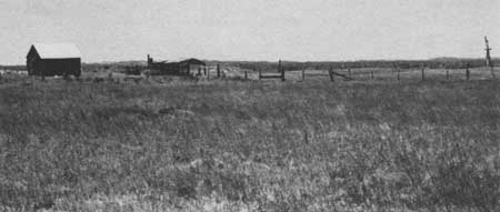
The long strips of vegetated barrier flat served historically as cattle rangeland. Remains of three line camps, where ranchers temporarily held cattle on their drive up the island, are still standing on Padre's barrier flats (fig. 83). Although cattle no longer graze within the National Seashore, the barrier flats are still permanent homes for various wild animals, such as pocket gophers, moles, weasels, ground squirrels, mice, and snakes. Other animals that visit the island occasionally are coyotes, shrews, bats, raccoons, skunks, rats, jackrabbits, and armadillos (Hunter and others, 1972). In addition, insects abound on the barrier flats; during spring and summer, mosquitoes may make themselves a little too obvious to Seashore visitors hiking across the flats. These insects thrive in the thickly vegetated and, in places, marshy environments that are protected by the dune ridge from onshore winds.
|
| Figure 83. Novillo (pl. I, grid T-4), the northernmost line camp constructed by Pat Dunn for cattle ranching on the island during the late 1800's and early 1900's. View is to the northeast. Padre Island's grass-covered barrier flats were good rangeland, and Laguna Madre on the west and the Gulf of Mexico on the east served as natural fences for the long, narrow island. When herding the cattle in preparation for market, Dunn's vaqueros, or cowboys, drove the cattle up the island in stages, holding them overnight in corrals at the line camps. |
Stabilized Blowout Dunes (B6)
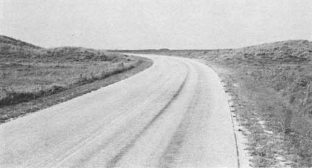
In many parts of the Seashore, vegetated elongate and curved sandy ridges or fields of low dunes extend lagoonward from the dune ridge. These dunes, up to 20 feet high, were once active blowout dunes (described below under map unit B10) that originated at the dune ridge and, after migrating some distance lagoonward, were stabilized by vegetation (fig. 84). Such vegetation consists primarily of grasses commonly found on the barrier flat.
|
| Figure 84. Park Road 22, which cuts through stabilized blowout dunes just north of the Bird Island Basin road intersection (pl. I, grid T-4). View is to the southwest. At one time, loose sand was blown out from the fore-island dune ridge by the prevailing southeasterly winds. The sand migrated lagoonward across the barrier flats and eventually was stabilized by vegetation in the middle part of the island. |
If the grass cover is destroyed either naturally or by people, the dunes may be reactivated and begin migrating downwind toward the back-island area. They may go through several cycles of stabilization and reactivation before becoming either "permanently" stabilized or merged with the back-island dunes.
Because the sediments of the stabilized blowout dunes were derived from the fore-island dune ridge, they resemble foredune sediments. The stabilized deposits include fine, well-sorted sand. Nearest the fore-island area, they contain small shells and shell fragments that were blown or washed from the beach.
Washover Channel (B7)
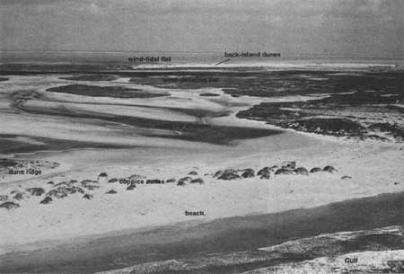
During hurricanes, the storm surge cuts through the fore-island dune ridge at low, weak points, scouring channels generally perpendicular to the shoreline. Nearshore (shoreface), beach, dune, and barrier-flat sediments are transported into the back-island areas (pl. I, B7 photograph, and fig. 85). Hurricane washovers generally consist of single channels up to 700 feet wide through the dune ridge. On the barrier flats behind the ridge, however, washover channels split into two or more smaller channels (fig. 85). The sediments in the washover channels are primarily sand and shell; some mud, however, settles from suspension in open channels during the waning stages of the storm ebb flow and in ponds remaining after the flow ceases.
|
| Figure 85. Hurricane washover channel at the 35-mile beach marker (pl. I, grid C-12). View is to the northwest. Generally, a single channel cuts through the dune ridge in the fore-island area, but the channel splits into two or more smaller channels on the flats beyond. After the storm, water may be ponded in the deep scours and occasionally replenished by rain, very high wind tides, or even ground water if the scour is below the shallow water table. Large coppice dunes are merging and forming an incipient dune ridge to close the mouth of this channel. |
Most ponds that form in the deepest parts of the inactive washover channels between storms exist only briefly. Where channels are scoured below the water table, however, the ponds retain brackish water and will not dry completely (fig. 85). Thin algal mats develop around the edges of the ponds and in other moist parts of the inactive channels. Mollusks are common in the ponds.
All washovers eroded during recent hurricanes, and those most likely to be reactivated during the next large storm, occur in the southern part of the National Seashore where the dune ridge is low and segmented. The first washover channel south of Malaquite Beach is about 17 miles south of Yarborough Pass. Older, healed washovers are located in grid U-11 (pl. I), almost 4 miles south of Yarborough Pass, and in grid H-4, 9 miles south of Malaquite Beach. These relict channels are not mapped on plate I as hurricane washovers, but rather as the various environments that have developed in them.
Wind-Deflation Flat, Storm Runway, and Washover Fan (B8)
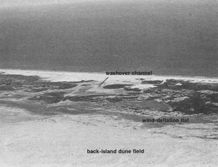
Barren flats, generally parallel to the Gulf shoreline, occur windward of large back-island dune fields (fig. 86). These wind-deflation flats (B8) are created when sand and finer sediments are scoured by the wind, commonly down to the water table. Sand is blown out into dunes, with coarser material lagging behind. Large shell and cobble lag constitute what is called "desert pavement" (fig. 63).
|
| Figure 86. Wind-deflation flat at the trailing edge of a back-island dune field (pl. I, grids W-20 and X-20). View is to the northeast. The flat, which was the sand source for the large dune field, now serves as a storm runway. Storm water is fed into the low flat from the washover channel and then flows parallel to the shoreline along the deflation flat. |
In the northern parts of the Seashore, where the deflation flats have become vegetated, they are mapped on plate I as one of the barrier-flat units (B4 or B5). In the south, however, the drier climate prevents the vegetating of the deflation flats, which occupy a large part of the barrier island.
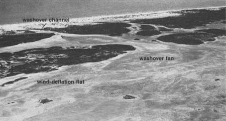
During storms, much of the sediment eroded from and transported through the washover channels is deposited on wind-deflation flats to produce washover fans. The fans are very low-relief lobes of sand and shell deposited where the washover channels widen and the storm waters lose velocity (fig. 87). In addition, some sediment is carried by the storm waters parallel to the shoreline along the wind-deflation flats, which serve as storm runways (Hayes, 1965). The deflation flats are normally connected with wind-tidal flats (L1, L2, and L3) between the dune fields. This means that very high wind tides in the lagoon will flood the flats. Thus, the boundary between the deflation flats and wind-tidal flats in some areas is not clearly defined.
|
| Figure 87. Washover fan spreading onto a deflation flat. The washover fan originates from the end of a washover channel (pl. I, grid V-20). |
Drapes of mud are deposited on the flats and fans by the calmer water that is drained off or remains ponded on them at the end of a storm. Mud drapes may also be deposited during wind tides. The mud layers crack and crumble as the exposed flats dry, and the fine material, as well as the sand below, is reworked by the wind. The loose sediment is either added to the back-island dunes or blown out onto the wind-tidal flats. Thin algal mats form and seal the sediment where the deflation flats are more frequently flooded by wind tides.
Ephemeral Fresh- to Brackish-Water Ponds and Marshes (B9)
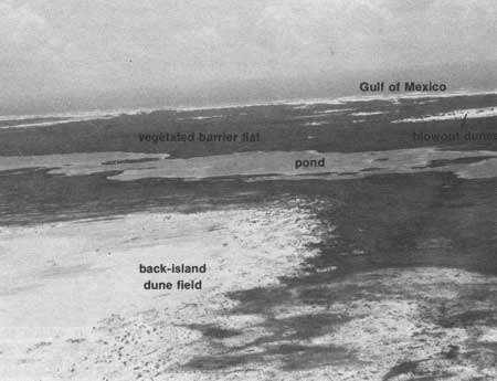
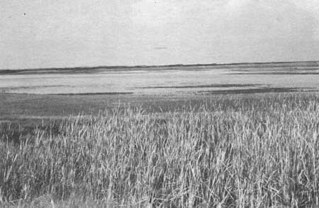
In the northern part of the National Seashore (pl. I), the deeper, troughlike wind-deflation flats become sites of ponds or marshes. Because most of the mapped ponds and marshes occupy long, linear deflation troughs left behind by migrating back-island dune fields (B10), the ponds parallel the trailing edges of the dune fields (fig. 88). Ponds and marshes nearer the fore-island area (fig. 89) occupy deflation flats left by fore-island blowout dunes (B10). As stated earlier, ponds and marshes too small to be mapped separately on plate I are included within the barrier-flat map units (B4 and B5).
|
| Figure 88. Ponds occupying long wind-deflation troughs, which parallel back-island dune fields (pl. I, grid O-3). View is to the east. |
|
| Figure 89. One of the marshy ponds that have developed in deflation flats left by fore-island blowout dunes. Several of these ponds can be seen near the Malaquite Beach development. View is to the west. |
The ponds and marshes are largely ephemeral, or short lived, but some retain fresh to brackish water over long periods and are replenished occasionally by rain. Plants in the marshy environments include various forms of algae, common cattail (Typha domingensis), American bulrush (Scirpus americanus), spikerushes (Eleocharis sp.) and others (Baccus and Horton, 1979).
The depressions in which the ponds and marshes develop are originally floored by the sediments, mostly sand, exposed in the deflation trough. During the periods of water ponding and marsh growth, however, mud and plant debris settle and cover the bottom. Windblown sand is trapped in the ponds, settles, and is mixed or interlayered with mud and organic material.
Back-Island Dune Field and Fore-Island Blowout Dunes (B10)
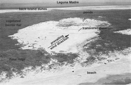
Those parts of the fore-island dune ridge that become devegetated naturally or through the actions of man are vulnerable to erosion by the strong southeasterly winds. Sand is blown from the dune ridge over the barrier flat in a northwesterly direction (fig. 90). The result is a blowout dune complex, which may consist of several dune types, including parabolic, transverse, and barchan dunes (fig. 39). Most dune forms change rapidly with changes in wind direction and intensity. The sediment composing these blowout dunes is mostly fine, well-sorted sand derived from fore-island dunes.
|
| Figure 90. Blowout complex that originated at the dune ridge, where stabilizing vegetation had been destroyed, and loose sand was free to blow out (pl. I, grid O-4). Prevailing southeasterlies cause the blowout to migrate across the island in a northwestward direction, although strong north winds modify the complex every winter by blowing much of the sand to the south edge of the barren dune complex (left side in photograph). Several dune forms, depending on wind direction, speed, and duration, occupy the complex at different times. Transverse dunes perpendicular to wind direction dominated this complex at the time the photograph was taken. |
As blowout dunes migrate toward the northwest across the barrier flat, they may either become stabilized by grasses or eventually become merged with a back-island dune field. The back-island dune fields are large barren areas of shifting dunes (fig. 91). Barchans and transverse dunes aligned perpendicularly to the wind direction are common in the back-island fields. These relatively small dunes are generally less than 10 feet high. Large (up to 25 feet high), elongate, longitudinal dunes (fig. 51) shift much less readily and may retain their orientations throughout the year. Hunter and others (1972) studied the large dunes on Padre and refer to them as oblique dunes because they are elongate in an east-west direction, or oblique to the net sand transport direction (fig. 49), which is a result primarily of the dominant southeasterlies and the north winter winds. One possible explanation for the relatively stable orientation of these dunes is that they are parallel to one arm of summer barchans and perpendicular to the north winds of winter (Hunter and others, 1972).

|
| Figure 91. Back-island dune field including several large, shifting dunes (pl. I, grid O-19). |
In the northern part of the National Seashore, fine sand is supplied to the back-island dune fields by the migrating blowout dunes. The back-island dunes in the southern part, however, are supplied largely by sand reworked from sediments that washed into the back-island area during storms. Presently, neither washovers nor large blowouts occur in the central part of the Seashore; consequently, the back-island area is starved of sand necessary to build large dune fields. What were once dune fields are now patches of vegetated barrier flat fringing the back-island area (for example, grids J-10 through M-10, pl. I).
Back-Island Sandflat (B11)
Environments that undergo rapid changes in size and dune forms are the barren back-island sandflats with small migrating dunes (pl. I, B11 photograph). These are environments transitional between the back-island dune fields (B10) and wind-tidal flats (L1, L2, and L3). Although a particular dune field may evolve in a number of ways, the back-island sandflat is one possible last stage in the life of a dune field.
Sandflats have developed only in the southern half of the Seashore, where fine sand from large dune fields blows across vast wind-tidal flats. There is no vegetation or lagoon water to trap the sand as occurs on north Padre Island. As large dunes are destroyed, the sand spreads to form the sandflats. Sand within the flats may form much smaller, rapidly migrating dunes — dominantly small barchans and transverse dunes. Elevation is low enough that the environment is flooded by storm tides and the highest wind tides. As the sand continues to spread and dunes become smaller, the elevation is reduced sufficiently so that the area is flooded by normal wind tides, and the environment evolves into a true wind-tidal flat.
| <<< Previous | <<< Contents >>> | Next >>> |
state/tx/1980-17/sec4.htm
Last Updated: 28-Mar-2007

