
|
Virginia Division of Mineral Resources Bulletin 86
Geology of the Shenandoah National Park, Virginia |
ORIGIN OF THE BLUE RIDGE
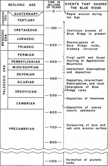
The geologic history of the Shenandoah National Park area is essentially the history of the evolution of the Blue Ridge mountains in north-central Virginia. To begin deciphering the order of geologic events that shaped the Blue Ridge, we must look again to the geologic time scale now in general use (Figure 31). This time scale, originally based on the order of occurrence of distinctive fossils in sedimentary rock sequences, was a relative time scale until the advent of radiometric age determinations. Radiometric dates have provided numerical ages for the various divisions of the time scale and have allowed age determinations to be made from many rocks that contain no fossils. In this time scale the last 570 million years have been divided into 12 periods of unequal duration beginning with the Cambrian (500 to 570 million years ago), the period in which the earliest known complex life forms developed and were preserved in the rocks as fossils. As the Precambrian rocks contain no known complex fossil forms, their age must be determined entirely by radiometric methods. It is during Precambrian and Cambrian time that most of the rocks in the Shenandoah National Park were formed.
|
| Figure 31. Geologic time scale showing estimated times of geologic events in the park area of the Blue Ridge. |
PRECAMBRIAN PLUTONIC ROCKS
The geologic history of the Blue Ridge in the park begins in Precambrian time with the formation of the plutonic rocks which include the Old Rag Granite and the Pedlar Formation. These rock units are part of a complex series of ancient meta-igneous rock bodies now exposed in the core of the Blue Ridge anticlinorium. They are coarsely crystalline, homogeneous to layered, very feldspathic granodiorite and granite. The mineral grains that form these rocks are of about equal size and interlock to form a mosaic pattern. This pattern or texture is characteristic of rocks that crystallized at very high temperature and pressure, conditions that can only be obtained deep within the earth's crust. These rocks may have crystallized from molten rock originating deep within the crust or they may have been part of an older layered rock sequence that was melted and recrystallized during Precambrian metamorphism. Radiometric age determinations suggest an age of approximately 1.1 billion years for the time of crystallization, placing these rocks among the oldest exposed in the Appalachians. As there is little question that the Precambrian crystalline rocks were formed at great depth, a long period of time, possibly as much as 300 million years, was required for uplift and erosion to bring them to the surface in late Precambrian time.
LATE PRECAMBRIAN SURFACE
The late Precambrian landscape carved from the plutonic rocks may have looked much as the land surface to the east of the Blue Ridge would look today if the present vegetation and soil cover were removed. The highest mountains on the ancient surface probably reached little more than 2,000 feet (610 m) above the valleys. The crests and upper slopes were probably barren, exposed rock with weathered rock debris on the lower slopes and in the valleys. Accumulations of stream sediments, locally more than 200 feet (61 m) thick, were spread over the valley floors by the larger streams. This bleak and barren, mountainous surface is now the surface preserved at the base of the layered rock sequence. This surface also became the floor of the Appalachian geosyncline, the broad trough in which sediments were intermittently deposited from the late Precambrian through Paleozoic time, a period of almost 600 million years. During this time these sediments became the rocks that now form the Appalachian Mountains.
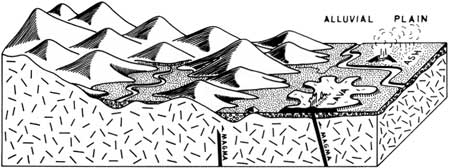
LATE PRECAMBRIAN VOLCANISM
In late Precambrian time lavas breached the surface through an extensive series of fissures in the plutonic rocks. These fissures opened periodically in late Precambrian time and spread molten lava and volcanic ash laterally forming very broad, sheet-like bodies from 30 to more than 100 feet (9-30 m) thick (Figure 32). The resultant stack of lava flows and lesser amounts of ash probably exceeded 2,000 feet (610 m) in thickness as remnants of the flows range up to at least 1,800 feet (529 m) in thickness. The lava covered most of what is now the Blue Ridge anticlinorium north of the James River and probably was far more extensive than its present surface distribution suggests. The total volume of lava ejected from the fissures may have exceeded 1,000 cubic miles (4,170 cubic km) and possibly could have been several times greater.
|
| Figure 32. Late Precambrian time and the beginning of volcanism. Lavas spread across sediment-filled stream valleys from vents along fissures in the granitic crust. |
The topography of the surface on the Precambrian plutonic rocks restricted the thickness and the regional distribution of the sedimentary and volcanic material that now forms the Swift Run and Catoctin formations. Buried hills of plutonic rocks exposed in the upper reaches of Rose River east of Big Meadows and in White Oak Canyon have been described by Reed (1955, 1969) who estimates that as much as 1,000 feet (305 m) of topographic relief may be present locally on the erosion surface. Other large buried hills were found in the northern section of the park during this investigation, one at the head of Big Devil Stairs and the other at Hogback Mountain. Six or more lava flows terminate laterally against the flanks of these hills, the crests of which may have stood as much as 700 feet (213 m) above the local Precambrian valley floors.
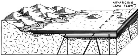
When the Catoctin lavas flowed out onto this ancient Precambrian surface, they filled the valleys and covered successively higher hills until all but the highest peaks lay buried beneath a broad plain of solidified lava and volcanic ash (Figure 33).
|
| Figure 33. Late Precambrian time with continuing volcanism, erosion, and sedimentation. Subsidence of the land surface begins, marking the initial downwarping of the Appalachian geosyncline. |
The lava flows did much more than bury the eroded surface; hot mineralizing fluids and gases from the advancing flows locally altered the exposed plutonic rocks. The alteration generally varied from place to place depending primarily on the degree of permeability of the rock material present at the surface. In the valleys and on the lower slopes, the sediments that are now the Swift Run Formation and much of the weathered plutonic rock debris was unconsolidated, permeable, and probably saturated with ground water when inundated by the lavas. Mineralizing fluids from the lavas altered the feldspars and other minerals, locally forming an epidote cement in the permeable weathered rock and sediments. Alteration is most evident in the material immediately beneath the flows, and it decreases downward; generally the upper 10 to 20 feet (3 to 6 m) of permeable surface material is visibly altered. In the granodiorite the epidote formed a matrix around pink feldspar and smoky-gray quartz grains, producing unakite, an attractive green, pink, and gray mineral assemblage. However, plutonic rocks that were exposed as Precambrian mountaintops show relatively little alteration except in the upper few feet or inches of granitic rock or along ancient fractures in the 50 to 100 feet (15 to 31 m) of rock below the erosion surface.
VOLCANIC SEQUENCE
Within the volcanic-sedimentary rock sequence that forms the Swift Run and Catoctin formations are a variety of rock types that fall into three general categories. First, the greenstones, formed from very mobile basaltic lavas, comprise 80 percent or more of the volcanic sequence. These are the resistant rocks responsible for forming all of the higher ridges in the park. Interlayered with the greenstones are thin discontinuous beds of purple slate, the second rock category, that originally was tuff or pumice deposited from volcanic ash blown from the fissures during more violent eruptions. The ash falls appear to have alternated with the less violent lava outflows. Also interbedded with the basalt and slate beds are sedimentary rock units formed from the pebbles, sands, and clays of stream deposits. This third category is now a sequence of phyllites and metasandstones with or without pebbles of quartz, granite, basalt, or tuff.
The intricate interlayering of the three rock types show that the various volcanic and sedimentary processes were going on concurrently. Eruptions of pumice and ash, which probably heralded the coming of the lava flows, dumped large quantities of fine debris on the Precambrian landscape choking the streams and forming thick ash deposits in the lowlands. The first surge of lava from the fissures covered only the lowest areas, pushing the streams aside or damming them to form lakes that soon spilled across the still hot lava beds. The streams carved into the lava beds and deposited reworked volcanic ash in their channels with sand and pebbles from the granitic highlands and the lava flows. These deposits, a mixture of volcanic and granitic material, became the rocks of the Swift Run Formation and the sedimentary rocks within the Catoctin Formation. Continued ash falls and ejections of lava blocked streams from many areas for long periods of time resulting in a sequence of alternating volcanic rock types almost devoid of sedimentary material. This sequence is characteristic of the northern and central sections (Plates 1, 2) where only thin discontinuous beds of sedimentary rocks are preserved. In the southern section (Plate 3) several stream systems were active intermittently during volcanism and have left a variety of clastic sedimentary rocks to mark their location. Sandstone, phyllite, and conglomerate beds are well exposed locally between Jarman Gap and the southern entrance to the park, each sedimentary unit commonly lying on volcanic ash beds (purple slates) and capped by greenstone lava flows. The presence of granitic pebbles in the uppermost sedimentary interbeds show that Precambrian granite peaks were still protruding through the lava beds near the end of volcanic activity.
The last volcanic event recorded in the rocks is a widespread ash fall that appears to have blanketed the entire Blue Ridge area in and near the park. This ash, now a purple, yellow spotted slate bed as much as 200 feet (61 m) thick, is the uppermost layer of the volcanic sequence and marks the boundary between the Catoctin Formation and the overlying Cambrian rocks.
ADVANCE OF THE CAMBRIAN SEA
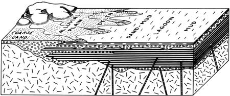
When volcanism ended, the streams reestablished their courses across the lava plains and deposited mud, sand, and quartz pebbles in their channels (Figure 34), which later became the rocks of the Weverton Formation. These sediments were largely derived from exposed portions of the Precambrian granitic surface that probably was a highland to the west, and which may have also blocked the westward movement of the lava flows. As the streams carried sediment into the area, subsidence in the form of a broad gentle downwarping of the land was underway and had probably been going on since the beginning of volcanism. As subsidence continued, the stream deposits were thickened until the stream systems were submerged and bogs and lagoons took their place, ever deepening as the early Cambrian sea approached from the east.
|
| Figure 34. Earliest Cambrian time after the cessation of volcanism and at the beginning of the westward advance of the Cambrian sea. Stream deposits near the remnants of the granite mountains form contemporaneously with lagoonal deposits. |
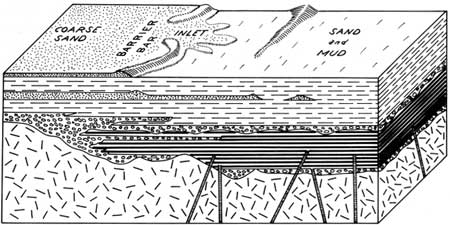
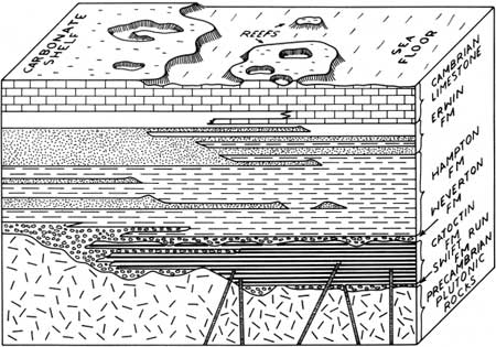
Early marine sediments of the Cambrian sea were fine-grained sandy muds and clays deposited in the quiet water of a lagoonal environment and protected from the turbulence of the open sea by offshore sandbars or barrier beaches along the seacoast (Figure 35). Soft-bodied marine worms living in the muddy sands that now form the thick sequence of metasandstones and phyllites of the Hampton Formation left burrows and trails; these fossil forms are the earliest indicators of ancient life preserved in the Blue Ridge. As the basin continued to subside the seacoast extended westward positioning beach and offshore bar environments in what is now the park area. The clean, white beach and bar sands accumulated to depths of 600 to more than 1,000 feet (183 to 305 m). These sands, from which the Erwin quartzites were formed, contained a profusion of worm borings or Skolithus, which are preserved as straight, vertical, tube-like fossil forms 3 to 5 mm in diameter and up to 1 meter (3 feet) in length. Steeply inclined bedding (cross-lamination), scour channels, and scattered quartz-pebble beds suggest that strong currents were present during the deposition of the sand beds. As the seacoast moved farther west the beach and bar environment followed, being replaced by a shallow off shore marine environment characterized by alternating mud and sand deposition that became increasingly calcareous as lime-precipitating organisms moved into the area. Eventually in Middle and Late Cambrian time most of the sediment being deposited in the basin was biologically or chemically precipitated calcium carbonate (Figure 36). Marine carbonate deposition continued through Cambrian and into Ordovician time forming the nearly 12,000-foot- (3,658 m-) thick limestone and dolomite rock sequence that underlies the Shenandoah Valley.
|
| Figure 35. Early Cambrian time as the basin deepens. Sand and mud deposits form along the sea margin. |
|
| Figure 36. Middle and Late Cambrian time. The influx of coarse sediment into the basin diminishes and is replaced by organically precipitated lime muds that continue to fill the very shallow, slowly subsiding Cambrian basin. |
Geologic events in the park area after deposition of the Cambrian and Ordovician carbonates is largely inferred from late Paleozoic rocks west of the Blue Ridge. Sediments ranging in age from Middle Ordovician through most of the Paleozoic probably were deposited intermittently over part or all of the park area, but have since been removed by erosion.
PALEOZOIC DIASTROPHISM
From about Middle Ordovician through Permian time (450-225 million years ago) (Figure 31) the rocks in the Appalachian geosyncline were subjected to a series of diastrophic events. These stress-related events produced folding, faulting, and metamorphism that ultimately formed the structures of the Appalachian Mountains. In the Blue Ridge the rock strata, reacting to the intermittent pulses of diastrophic forces, were warped into a series of folds and broken along faults (Figure 37). Stresses within the rocks were dissipated by mineral recrystallization and slippage along newly formed fracture surfaces that were generated during folding. Heat produced by this stress release and by the geothermal gradient (the rocks were at least 2.5 miles or 4.0 km below the surface and possibly much deeper) allowed new minerals, stable at the higher temperatures, to form during the recrystallization. The greatest alteration of mineral grains occurred in those areas where stresses were greatest, as within zones of intensely sheared and mylonitized plutonic rocks or in sharply overturned and attenuated fold limbs. Biotite, a common metamorphic mineral and indicator of relatively high temperatures and pressures, was found in many of the rocks of these more intensely deformed areas. The visible results of metamorphism are pronounced in many of the rock types in the park. The quartzites of the Erwin Formation, originally well-sorted quartz sand beds, are now very hard and glassy rock with most of the original texture obliterated by the recrystallization of the quartz sand grains. The phyllites of the Hampton and the purple slates of the Catoctin, once sandy muds and volcanic ash beds, are now platy quartz-sericite rocks in which most of the original sedimentary or volcanic structures have been destroyed by dislocation and recrystallization. The greatest change occurred within the plutonic rocks where they were crushed and milled to form mylonite along several zones of intense dislocation or shear. The appearance of mylonite, a very fine-grained, drab, slaty rock, belies the granitic character of the parent rock. Other visible evidence of the diastrophic events is the universal fracturing of the rocks, most of which is related to stresses applied during diastrophism.
|
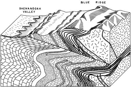
| Figure 37. Present land surface and its relation to the rock formations and structures. |
The assemblages of metamorphic minerals in the rocks of the Blue Ridge show that metamorphism during the Paleozoic took place at a relatively shallow depth, probably less than 6 miles (10 km). Also, the metamorphic minerals were formed concurrently with the cleavage development and folding, which suggests that the upward arching of the Blue Ridge anticlinorium, an event related to folding, was underway at the time of metamorphism. Southwest of the park in the Valley and Ridge province Ordovician sedimentary rocks contain a few pebbles and boulders of the sedimentary and volcanic rock of the Blue Ridge. This is positive evidence that the Blue Ridge rock sequence was at the surface and subjected to erosion during Ordovician time, a condition that would require a vertical uplift of several miles. The occurrence of these pebbles and boulders in the younger Ordovician rocks may be the only record of this early diastrophic event in the development of the Blue Ridge. Other and possibly stronger diastrophic events followed in later Paleozoic time and these may account for much or most of the folding, faulting, and metamorphism but direct evidence of Blue Ridge emergence and erosion in the post-Ordovician Paleozoic rocks is more difficult to substantiate.
MESOZOIC EVENTS
During the Triassic Period continental sediments accumulated in a number of basins east of the Blue Ridge and boulders and cobbles derived from formations now exposed in the Blue Ridge made up a large part of the coarse material in these deposits. In addition, the presence of granitic boulders in the Triassic rocks is evidence that the plutonic rocks in the core of the Blue Ridge anticlinorium had been breached by erosion and that the Blue Ridge mountains were standing well above the surface of the Triassic basins. The Triassic and following Jurassic periods were also times of volcanism and mafic intrusion. Diabasic magma moved upward along fractures in the Blue Ridge and adjacent areas although only a few of the resultant diabase dikes have been found in the park. From Triassic time to the present the rocks of the Blue Ridge may have been at the surface continuously and if so were probably forming a mountain range.
CARVING OF THE MOUNTAINS
The present mountain landforms of the Blue Ridge have probably been evolving since Triassic time. Weathering and erosion impinging on the elevated rock masses have locally lowered the mountain surface at rates relative to the resistance of the various rocks on that surface, the resistance to weathering and erosion being governed by the chemical (mineral) composition and internal structure of the rocks. Common rock-forming minerals in the Blue Ridge consist of silica, very resistant to weathering and relatively insoluble in water; mica and feldspar, less resistant and more soluble; and calcium and magnesium carbonate minerals, the least resistant and among the most soluble. As all rocks of the Blue Ridge have been metamorphosed, the original open spaces (pores, vugs) have been destroyed by recrystallization, so that the only open spaces through which water has been able to enter and induce mineral solution is through fractures (joints, cleavage, faults) formed during diastrophism. These controlling factors, mineral composition and fracture frequency, are variable from place to place and react accordingly to weathering and erosion. The differential removal of rock material from the variably deformed heterogeneous rock sequence of the Blue Ridge has resulted in a great variety of landforms and elevations (Figure 37). Quartzite beds, composed of nearly pure silica make higher ridges than phyllite, which is rich in mica. Limestone and dolomite (calcium and magnesium carbonates) form the lowlands of the Shenandoah Valley with only a few low ridges where sandstone or chert beds within the limestone provide some resistant silica. The thicker remnants of volcanic rocks form the highest ridges. Also where the normally resistant ridge-forming rocks, quartzite or basalt, are present in overturned fold limbs or along faults or shear zones only lower ridges or small valleys are present. Faults or shear zones commonly appear as linear topographic lows between the less deformed mountain-forming rocks.
The distribution of the landforms (mountains, valleys, ridges) and the location of the drainage network is best explained by natural differences in erosional rates and does not require recent tectonic uplift or subsidence as a mechanism for forming specific topographic features. Uplift of the Blue Ridge and surrounding areas has certainly occurred in the geologic past, as evidenced by the presence of the rocks in the Blue Ridge that could only have formed deep within the crust. Uplift may still be going on, but at such a low rate that weathering and erosion have maintained a mountain and valley topography that expresses only the distribution of resistant and nonresistant rock.
In the past million years during the Pleistocene Epoch, four periods of continental glaciation brought significant changes in the climate of North America. Although the glacial ice approached from the north and northwest to within 200 miles of the park as recently as 7,000 years ago, no evidence for glaciation in the Blue Ridge has been found. The glaciation to the north was accompanied by a major decrease in temperature and an increase in rainfall in the Blue Ridge which together accelerated weathering and erosional processes. Some effects of the climatic changes are still visible in the park (Hack, 1966). The extensive talus deposits formed of Erwin quartzites or other resistant rock units are the result of the Pleistocene weather. These deposits appear to be weathering and disintegrating more rapidly than they are being formed. Also, much of the sand and boulder material in the wide alluvial fans sloping gently westward into the Shenandoah Valley must have been deposited during periods of heavy rainfall in the past million years. These deposits are now being actively eroded by streams issuing from the Blue Ridge, probably the same streams that formed the deposits initially.
Thus we reach the present hoping to have explained in some part the origin of the Blue Ridge rocks and structures and the development of the topographic forms that we see.
| <<< Previous | <<< Contents >>> | Next >>> |
state/va/vdmr-bul-86/sec4.htm
Last Updated: 28-Nov-2007