
|
Virginia Division of Mineral Resources Bulletin 86
Geology of the Shenandoah National Park, Virginia |
STRUCTURE
Deformation of the rocks in the Blue Ridge may be seen as contorted strata where folds are present, as shattered masses of quartzite (tectonic breccia) in zones of faulting, or as linear zones of dark, contorted, slaty mylonite formed by the crushing and milling of granitic rocks along faults or shear zones. The deformation is expressed microscopically by the parallel alignment of micas or stretched and flattened sand grains in the sedimentary rocks and by the shattered and crushed crystals in the plutonic rocks. The deformation is also expressed as a broad regional warping of rock units and fold systems too large in scale to be viewed directly.
The dominant structural feature, one that can be found in most rock exposures in the park, is the pervasive cleavage, a parallel, planar fracture or shear fabric that generally has a southeasterly dip and a northeasterly trend. It is best developed in the very fine-grained micaceous metasedimentary rocks (Figure 20), metatuffs, and mylonites. Even the normally massive granitic rocks and the hard quartzite strata of the Chilhowee Group have well-developed cleavage where the rocks have been subjected to intense deformation along fault zones or in attenuated fold limbs. The cleavage is genetically related to the folding and metamorphism that accompanied the tectonic uplift and northwesterly transport of the Blue Ridge mass in Paleozoic time. It is the remaining visible evidence of small, parallel zones of dislocation in the rock that was formed during this tectonism, and it was the mechanism that, through differential slip along innumerable shear planes, allowed folding to develop during periods of compression. Cleavage planes are not always planar but may be slightly kinked or crenulated locally by a younger, less well-developed cleavage.
Jointing, near-vertical or subhorizontal fracturing, is as pervasive as cleavage, with most rock outcrops displaying many fractures and several fracture-trend directions. Jointing is most visible in the resistant quartzite ledges of the Erwin Formation, or in the massive granites displayed on the crest and cliffs of Old Rag Mountain (Figure 8). Jointing may be related to the folding or may be a postfolding development related to deep vertical adjustments in the crust.
Large asymmetric folds are common and locally visible in the southern section of the park where the rocks of the Chilhowee Group are extensively exposed. Folds having amplitudes of several hundred to several thousand feet can best be seen where the Weverton or Erwin quartzites are involved. The resistant white ledges of the lower part of the Erwin Formation outline an array of folds north of Big Run in the Brown Mountain-Rocky Mount area, some of which are visible even through heavy summer foliage from Twomile Run (Figure 27) and Big Run overlooks (Plate 3). Erwin ledges of a steep fold limb on Rocks Mountain can be seen from Skyline Drive between Riprap and Calvary Rocks overlooks. As one approaches the Erwin ledges along Calvary Rocks trail from Skyline Drive, moderately westward-dipping quartzite beds on the east limb of a syncline are encountered. Here, cleavage is nearly perpendicular to bedding and has been preferentially developed parallel to the once-vertical Skolithos tubes that now weather out in relief on the southeastward-dipping cleavage surfaces.
|
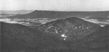
| Figure 27. Anticline nd syncline outlined ledges of the lower portion of the Erwin (Antietam) Formation west of Twomile Run Overlook (Plate 3). These large asymmetric folds are typical of those that are developed in the Chilhowee rocks along the west side of the Blue Ridge. In the distance the trend of the parallel limbs of the Massanutten synclinorium, defined by Silurian quartzites that form the ridge crests, differs greatly with the apparent trend and plunge of the folds in the Erwin quartzites. |
Small-scale folds with amplitudes and frequencies of less than 100 feet (31 m) are also common to rocks of the Chilhowee Group. There are few exposures in which both limbs of even the smaller folds can be viewed, and these occur only in the southern section (Plate 3). Small folds developed in the over turned west limb and axial portion of a larger anticline can be seen by the fire road along Paine Run north of Rocks Mountain. In the Loft Mountain area, where the Appalachian Trail leaves Ivy Creek and leads uphill to Ivy Creek Shelter, it extends across the hinge or axis of a small overturned syncline in the lower quartzite ledge of the Weverton Formation. The right-side-up base of the quartzite ledge is just above trail level where the trail parallels the creek. As the trail crosses the quartzite outcrop and leads uphill to the shelter the base reappears being overturned and inclined steeply to the southeast. If the base of the Weverton Formation is traced to the west, across Ivy Creek and along the south slope of Patterson Ridge, two additional small-scale folds can be seen. A sharply overturned anticline-syncline pair with a partly faulted-out or strongly attentuated overturned limb is present on the lower slope of Patterson Ridge in Eppert Hollow. These folds are typical of the small-scale folds found in the Chilhowee Group, and are mentioned here as they are very accessible.
Faults occur locally in all sections of the park and have had a strong influence on the location, shape, and development of the Blue Ridge. The presence of a fault is generally marked by linear low areas that are formed on the broken rocks or by the foot of an escarpment where resistant and nonresistant rocks are separated by the fault. Faults are commonly obscured by talus, alluvial gravel deposits, or deep soil and saprolite developed on the intensely fractured rocks along the fault trace. Bedrock exposures of fault surfaces are rare, but generally contain evidence of intense deformation such as brecciated or mylonitized rock.
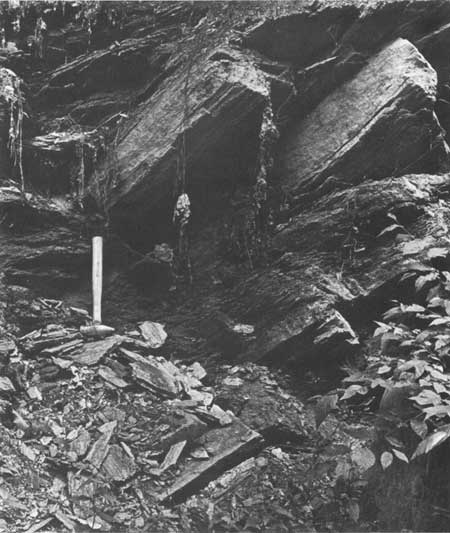
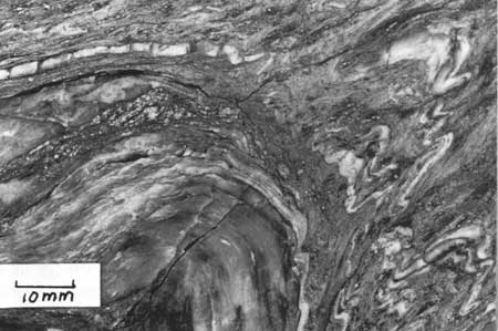
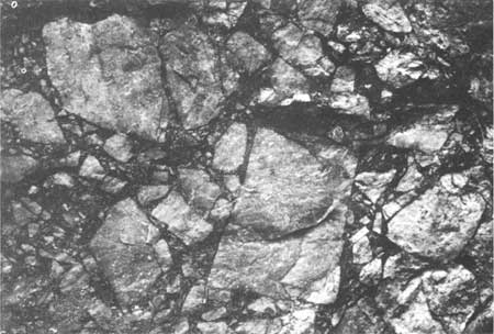
Linear zones of sheared rocks (mylonite and cataclastic gneiss) separate extensive areas of weakly foliated to massive crystalline rock. The mylonites (layered slaty rocks) and the cataclastic gneisses (coarse-grained, layered crystalline rocks) are thought to have developed along faults or shear folds in the plutonic rocks (Figure 28). The zones of sheared rocks are slightly sinuous, generally trend northeastward and may be as much as 0.25 mile (0.40 km) wide. The intensity of deformation varies within the zones. Mylonite (R-4396, R-4397, R-4455, R-4458) is characteristic of the most intense deformation and is present locally within the zones; protomylonite or cataclastic gneiss (R-4395, R-4462, R-4465, R-4466) are characteristic of somewhat less intense deformation and occur near the boundaries of the zone with the relatively unsheared plutonic rocks. Masses of relatively undeformed plutonic rock may be present at places within the sheared rock zones (R-4454) and small folds in layered mylonite are present locally (Figure 29). The basalts of the Catoctin Formation are less intensely deformed along faults, although some shearing and brecciation are present. Generally faults in the Catoctin Formation are characterized by a lack of bedrock exposure, extensive talus deposits, and a trace of vein quartz rubble in the soil. The quartzites of the Erwin Formation provide the most spectacular evidence for faulting. Where faults cut through this formation, tectonic breccias consisting of large masses of coarse, white, sharply angular, quartzite fragments (R-4411) bound together by a dark-red iron-oxide cement mark the fault trace (Figure 30). Breccia masses and layers occur locally along the west foot of the Blue Ridge between Front Royal and Stanley along the trace of a complex system of reverse or thrust faults, and in the Elkton and Waynesboro areas along similar faults or attenuated and collapsed fold limbs (Plates 1, 2, 3; Figure 5B).
|
| Figure 28. Strongely lineated protomylonite along State Road 600 approximately 2 miles (3 km) southwest of Sperryville (Plates 1 and 2) and 0.5 mile (0.8 km) east of the park boundary. North of Old Rag Mountain this mylonite zone lies between the Old Rag and Pedlar formations. Locally, within the zone the mylonites appear as coarse-grained layered rocks. |
|
| Figure 29. Sawed surface of refolded mylonite from near the locality shown in Figure 28. The layering developed during shearing of the granitic rocks and was folded during a later stage of deformation. |
|
| Figure 30. Brecciated Erwin (Antietam) quartzite formed along a transverse fault on Hershberger Hill approximately 3.5 miles (5.6 km) due west of Skyland. The angularity of the quartzite fragments shows that very little movement occurred along the fault. Red iron oxide cement fills the voids and forms a very resistant rock. |
Faults within the park fall into two general categories. Of most importance are the high-angle reverse faults and thrust faults along which the upper block has moved up or out over the lower block. In and near the park these faults are inclined to the southeast at low to high angles and are laterally extensive. Displacement of the rocks is up to many thousands of feet (several kilometers) locally, resulting in large masses of the Precambrian and early Cambrian rocks being moved upward onto the younger Paleozoic carbonate rocks of the Shenandoah Valley (Plates 1, 2; Figure 5B).
Very high-angle, northwestward-trending transverse faults comprise the second category of faults. These trend to the northwest across the Blue Ridge, and have small vertical displacements, generally less than 500 feet (152 m). The transverse faults may have formed simultaneously with the reverse or thrust faults. Those portions of the reverse faults shown on Plates 1-3 which have a westerly trend may be in effect very steeply inclined transverse faults, the south side of which may have been upthrown and moved westward with the thrust- or reverse-fault movement.
Very large-scale structures of alternating upwarped and downwarped masses of Precambrian and Early Cambrian rock, each 10 to 20 miles (16 to 32 km) long, form a series of lobes and embayments with the Shenandoah Valley along the west side of the Blue Ridge (Figure 5B). These broad, fold-fault structures account for the unequal distribution of the Chilhowee rocks along the west side of the park. The northwesternmost exposures of Precambrian rocks occur in the central portion of these broad areas, and the northeastward-trending folds that cross the lobes (Plates 1-3) have a plunge away from the Precambrian exposures to the northeast and southwest. Each lobe is bounded on the north by westward-trending fault segments along which the rocks to the south of the faults appear to have been uplifted and moved west or northwest relative to rocks north or northeast of the faults.
| <<< Previous | <<< Contents >>> | Next >>> |
state/va/vdmr-bul-86/sec3.htm
Last Updated: 28-Nov-2007