
|
Virginia Division of Mineral Resources Bulletin 86
Geology of the Shenandoah National Park, Virginia |
STRATIGRAPHY
The bedrock of the Shenandoah National Park is Precambrian, Cambrian, Ordovician, and Triassic in age (Figure 6). However, formations in small areas of the western part of the park that are younger than the Cambrian Erwin Formation were not mapped (Plates 1, 2, 3). Also, for simplification of the geologic maps, Quaternary alluvium and other surficial deposits are not shown.
|
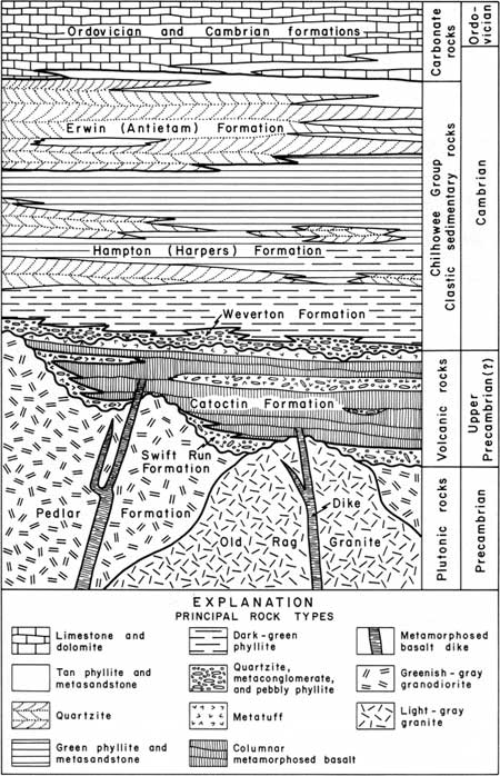
| Figure 6. Generalized columnar section of rock formations in Shenandoah National Park, Virginia.(click on image for a PDF version) |
Numbers preceded by "R" in parentheses (R-4460) correspond to sample localities; those preceded by "F" (F-868) correspond to fossil localities (Plates 1, 2, 3). These samples are on file in the repository of the Virginia Division of Mineral Resources where they are available for examination.
PRECAMBRIAN ROCKS
The rocks in the core of the Blue Ridge anticlinorium that underlie portions of the Shenandoah National Park belong to extensive, metamorphosed plutonic bodies more than a billion years old (Tilton and others, 1958). These rocks are characterized by mineral compositions that range from granite to granodiorite and by granoblastic and cataclastic textures that indicate periods of intense metamorphism. Many of the higher peaks such as The Pinnacle, Oventop Mountain, and Old Rag Mountain are formed of these rocks as are most of the lower peaks and much of the lowlands on the eastern flank of the Blue Ridge.
Old Rag Granite
The Old Rag Granite, named and described from exposures on Old Rag Mountain (Plate 2) by Furcron (1934), is the most distinctive plutonic rock body in the park. The formation is unconformably overlain by the Catoctin and Swift Run formations west of Old Rag Mountain, and it is gradational into or in fault contact with the Pedlar Formation in other areas. It is a light-gray to nearly white, coarse-grained, porphyritic rock of granitic composition that is resistant to weathering and forms bold, extensive outcrops on several mountaintops. The granite is composed mainly of blue quartz and perthitic microcline. Many of the feldspar crystals exceed 1 inch (3 cm) in length (R-4459). The Old Rag Granite is almost devoid of dark minerals, containing only small amounts of chlorite, epidote, magnetite and/or ilmenite, and sphene (R-4456). A weak compositional layering of elongate patches and stringers of quartz forms a subtle foliation in the otherwise massive-appearing rock. Along the contact zone with the Pedlar Formation the Old Rag Granite tends to be a finer grained, well-foliated granite or granite gneiss with small amounts of fine-grained biotite.
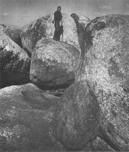
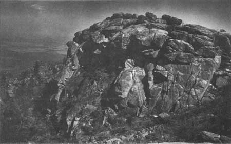
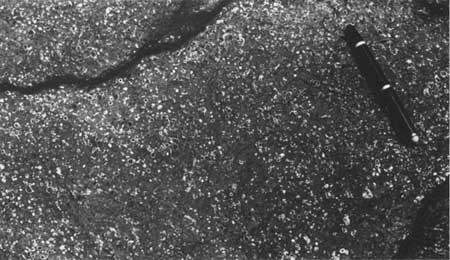
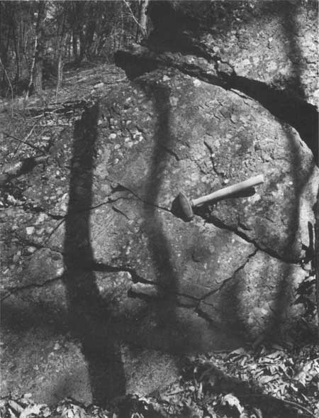
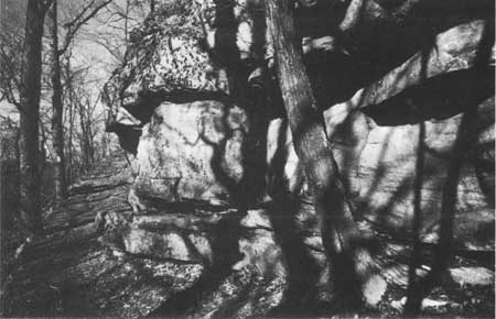
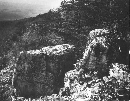
The Old Rag Granite is well exposed on the crest of Old Rag Mountain (Plate 2), which is accessible to hikers by the Ridge Trail from a parking area at the end of State Road 600 in Madison County or by White Oak Canyon Trail and Old Rag Road from the Skyland area of the Park. Where the mountain crest is locally devoid of vegetation and soil, large areas of unweathered, coarse-grained granite are exposed. The rock surface is notably abrasive due to microfracturing of the coarse quartz and feldspar grains that weather out in relief (R-4453). Large spheroidal boulders, some more than 10 feet in diameter (Figure 7), are clustered chaotically on the higher points of the mountain and are evidence of the severe wind and water erosion that prevails on the crest of the Blue Ridge. These boulders have been formed essentially in place from originally orthorhombic-shaped joint blocks of granite such as those exposed in the cliff faces on the north side of the crest. Many of these joint blocks have been partially rounded on their exposed edges (Figure 8), and a few of the smaller blocks have become well rounded. Along the crest of the mountain the granite is cut by several northward-trending, diabasic greenstone dikes (altered basalt), which probably represent ancient conduits through which basalts of the Catoctin Formation were extruded (R-4460). Several of the smaller dikes are well exposed along Ridge Trail on the crest of the mountain (Figure 9), but the larger ones that may be several tens of feet in width are defined only by scattered blocks of diabase in linear depressions trending to the north across the mountain crest. Many exposures of Old Rag Granite may also be found on Oventop Mountain north of U. S. Highway 211 between Thornton Gap and Sperryville (Plates 1, 2). The crest of Oventop Mountain is also cut by many dikes similar to those on Old Rag Mountain.
|
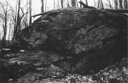
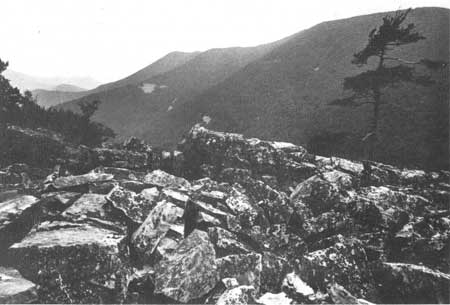
| Figure 7. Boulders on the crest of Old Rag Mountain were formed by the direct action of wind and water on exposed blocks of granite. |
|
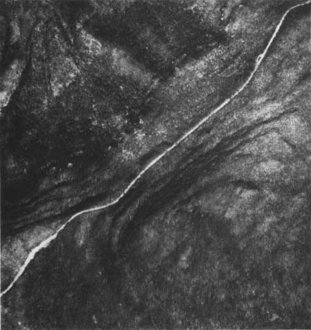
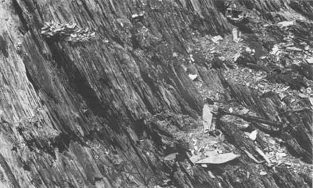
| Figure 8. Vertical, subhorizontal, and moderately inclined joints exposed on the west face of the main crest of Old Rag Mountain. These joints form orthorhombic blocks that, when exposed to weathering, produce sub-spherical boulders as shown in Figure 7. |

|
| Figure 9. Greenstone dike that forms a flight of natural stairs between granite walls along the Ridge Trail on Old Rag Mountain. The stair-like surface on the dike is the result of selective weathering of columnar joint blocks that formed perpendicular to the granite walls during cooling of the basaltic magma. |
Pedlar Formation
The name Pedlar Formation was first applied to rocks exposed in the Blue Ridge along the upper reaches of Pedlar River in Amherst County, Virginia (Bloomer and Werner, 1955). Within Shenandoah National Park the Pedlar Formation was first used as a mapping unit (Allen, 1963) for the hypersthene granodiorites and related rocks in Madison and Greene counties. More recently the rocks mapped as the Pedlar have been referred to as hypersthene-bearing granulites (Reed, 1971) and as charnockites (Herz, 1969), which are probably more meaningful classifications as they give the connotation of originally high metamorphic-rank plutonic rocks.
The Pedlar Formation is unconformably overlain by the Swift Run and Catoctin formations along the flanks and crest of the Blue Ridge mountains, and by the Weverton Formation in one area near the westernmost extension of the park in the central section. On the east side of the Blue Ridge in the central and northern sections (Plates 1, 2), the Pedlar Formation is in fault contact with the Old Rag Granite along shear zones or grades laterally into it across a transition zone that ranges up to more than a mile in width. A dike or sill of granodioritic material similar in composition to the Pedlar is present on the crest of Old Rag Mountain (R-4461).
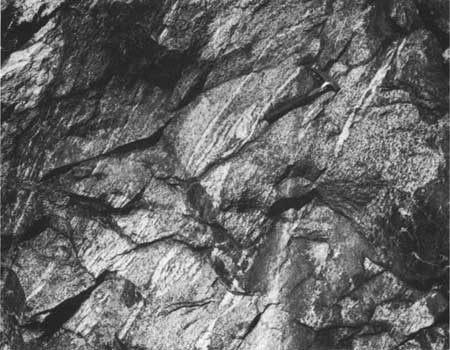
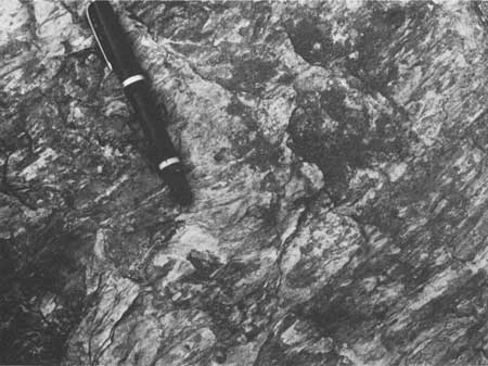
The unweathered rocks of the Pedlar Formation are medium to dark greenish or bluish gray, and commonly have a waxy or greasy luster on a broken, unweathered surface (R-4448, R-4398). They may have a generally massive appearance with only a faint linear or planar fabric, or a gneissic foliation of alternating dark and light mineral layers (Figure 10). More frequently elongate clots of dark minerals in a light-gray matrix give the rocks a diffuse, spotted, or lined appearance (R-4407). The rock is generally fine- to medium-grained granodiorite or quartz monzonite composed largely of plagioclase feldspars and quartz, with the dominant dark minerals being either hypersthene and augite or biotite, hornblende, and garnet. Microscopically, the mineral grains are of uniform size and have sutured, interlocking grain boundaries that define a well-developed granoblastic fabric probably indicative of complete recrystallization during a major metamorphic event. The granoblastic fabric has in itself been altered by shearing that has formed parallel slip planes, shear zones, and mylonites (zones of slaty, crushed rock) that locally transect all of the plutonic bodies. Within these shear features or fault zones the granoblastic fabric may be destroyed, and replaced by an aligned mineral assemblage of quartz, sericite, and chlorite (R-4422, R-4450, R-4452).

|
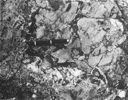
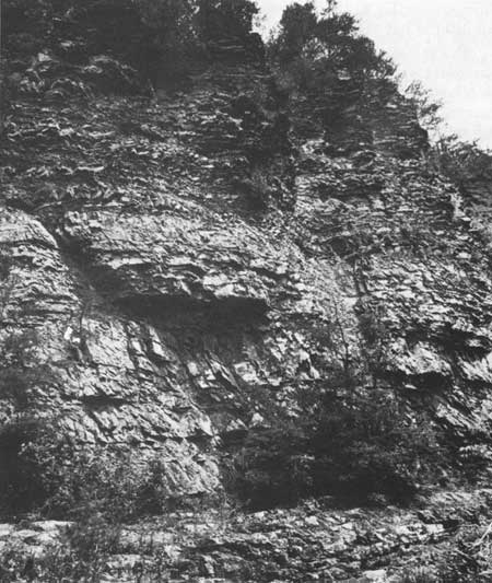
| Figure 10. Gneissic hypersthene granodiorite of the Pedlar Formation at the south portal of Marys Rock Tunnel (Plate 2). One of the best exposures of the gneissic or layered phase of this rock unit in the park. |
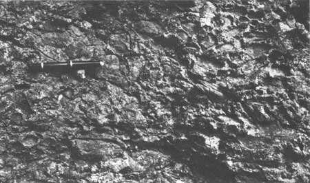
The layered variety of granodiorite is more prevalent in the northern half of the park (R-4389), although massive and spotted varieties occur locally. In the layered granodiorite small lenses and stringers of white granitic rock, similar to the Old Rag Granite, locally occur between dark hornblende or biotite rich layers (Figure 11). Good exposures of layered granodiorite are at the Tunnel Parking Overlook at Marys Rock Tunnel on Skyline Drive (Plates 1 and 2) and along U. S. Highway 211 near the Piedmont Picnic Area. The more massive, lineated or spotted varieties are prevalent east of Skyline Drive in the central and southern sections (R-4407), and are well exposed along U. S. Highway 33 east of Swift Run Gap.
|
| Figure 11. Granite gneiss on the north side of Skyline Drive, 0.3 mile (0.5 km) south of Land Run Gap (Plate 1). Although not typical of this formation, rocks of this type occur locally within the Pedlar granodiorite in the northern section of the park, and they are similar to gneissic rocks exposed in the core of the Blue Ridge anticlinorium east of the park. In this exposure the light-hued layers of quartzo-feldspathic material seem to outline tight, steeply plunging folds. |
PRECAMBRIAN (?) ROCKS
Swift Run Formation
The Swift Run Formation is a discontinuous sequence of metaconglomerate, metasandstone, tuffaceous phyllite (R-4417), and coarse-grained volcano-clastic rocks that unconformably overlies the plutonic rocks. It was formed from debris that was eroded from the plutonic rocks and from volcanic ash and coarse volcanic debris which was ejected during the earlier phases of volcanism. The formation grades upward into the Catoctin Formation and is interbedded with it in many areas. The Swift Run ranges up to 200 feet (61 m) in thickness being absent in some portions of the park.
The heterogeneous nature of the Swift Run is its most dominant characteristic. Phyllites grade laterally into metasandstones or metaconglomerates within a few hundred feet. Coarse volcano-clastic rocks predominate in some areas and locally thin beds of metabasalt may be interbedded with any of the other rock types of the formation. Excellent exposures of the Swift Run can be seen on Skyline Drive at Hensley Hollow Overlook, in the northern part of Lewis Mountain Picnic Area, and on the trail east from Bear Fence Mountain Overlook (Plate 2). Characteristic exposures of interbedded conglomeratic phyllite and metasandstone are present in the first roadcut south of Powell Gap (Plate 3). The coarse volcano-clastic phase is exposed on the south side of Skyline Drive between Compton Gap and Indian Run Overlook (R-4391) (Plate 1). Very good exposures of the formation are present on the Mount Marshall fire road about 1.0 mile (1.6 km) east of Hogwallow Flats (Plate 1). Coarse meta-arkose (R-4394), quartzite with cross laminations having steep dips, and brown, silver-gray, and purple tuffaceous phyllites are exposed along the fire road near Sprucepine Branch.
Catoctin Formation
The Catoctin Formation is a thick multilayered sequence of resistant volcanic and sedimentary rock that caps most of the higher mountains in the park. The formation contains many volcanic and a few sedimentary rock types but is characterized by a preponderence of metamorphosed basalt beds that were once ancient lava flows. Thin beds of metamorphosed sandstone, conglomerate, volcanic breccia, and tuff are interbedded with the metabasalt. In the park and nearby areas the formation ranges up to about 2,000 feet (610 m) in thickness; it is absent in at least one area near the western park boundary. The Catoctin overlies or is interbedded with the Swift Run Formation along its lower boundary except where the Swift Run is absent; in those areas the volcanic rocks lie directly on the plutonic rocks.
The Catoctin volcanic rocks are best exposed along Skyline Drive in the northern and central sections of the park (Appendix; Plates 1, 2) where the rocks occur on the upright limbs of several large fold structures and are not greatly deformed. In these less deformed areas many of the original features of the volcanic rocks are still present as they survived metamorphism with little visible alteration (Figure 12).
|
| Figure 12. Metabasalt ledge of the Catoctin Formation above Big Bend fire road 0.5 mile (0.8 km) north of U. S. Highway 33 east of Swift Run Gap. The layering in the ledge may be an original layering of the lava flow. |
Within the volcanic sequence the ancient lava flows are the most resistant beds and form topographic benches where the beds are upright. From 12 to 16 benches with intervening rock cliffs and debris slopes are present on Mount Marshall (Figure 13, Plate 1) and Spittler Hill (Plate 2). A series of these benches may be seen from the crest of Stony Man looking down slope toward Skyland Lodge (Plate 2). The metabasalt is very dense, tough, and generally dark-green, grayish-green, or purple. It is composed of fine-grained albite (feldspar) laths in a matrix of very fine-grained chlorite, actinolite, epidote, and pyroxene with varying amounts of magnetite and ilmenite. Where large amounts of epidote are present the metabasalt is pale green and very brittle. Columnar-joints—closely packed, near vertical, polygonal blocks many feet high—that formed while the lavas were cooling, are well displayed on Stony Man, Little Stony Man, and Compton Mountain (back cover; Plates 1, 2). The upper and lower portions of the basalt beds are commonly amygdaloidal. The amygdules are relic gas cavities now filled with coarsly crystalline minerals—quartz, epidote, chlorite, or calcite (Figure 14 and R-4457). They range from microscopic in size near the center of the basalt beds to about 1.0 inch (2.5 cm) near the upper or lower surfaces.
|
| Figure 13. Aerial photograph that delineates the series of Catoctin lava flows capping Mount Marshall (Plate 1). Browntown Valley Overlook and Skyline Drive have been constructed along the northwest side of the mountain on a bench formed on the top of one of the lava flows. |
|
| Figure 14. Amygdaloidal basalt on Bucks Elbow Mountain, 0.9 mile (1.4 km) east of Jarman Gap (Plate 3). This rock type occurs in the upper few feet of many basalt flows and consists of a dark-green, very fine-grained metabasalt with many small amygdules having epidote or jasperoid centers with quartz rims. In this flow the effusion of gases from the cooling lava virtually formed a froth before it solidified. |
A few metabasalt beds in the Big Meadows (Plate 2) and Loft Mountain areas (Figure 44, Plate 3) have coarse, white to pink crystals of plagioclase feldspar in the dark-green or purple metabasalt matrix. The porphyritic beds were traced extensively by Reed (1969) in the Big Meadows area and their distribution suggests that these porphyritic lavas covered many square miles of the land surface when they were formed, and may be representative of the distribution of other less easily traceable lava beds.
Volcanic breccias mark the boundaries between the lava flows in many areas. The breccias consist of a chaotic zone of coarse, angular blocks and smaller fragments of the basaltic lavas with quartz, epidote, or jasper filling the void space between the clasts (Figure 15, R-4423). The coarse lava fragments are parts of an early crust formed on the lava that, during later movements of the still liquid inner portion of the flow, shattered and collapsed into the upper part of the flow or fell from the advancing lava front to be overridden and buried as the flow moved forward. The fragments of metabasalt tend to be amygdaloidal as they were derived from the outer flow surfaces where gas bubbles were more likely to be abundant. Local, irregular masses of breccia several tens of feet thick may represent the zone of collision between flows where collapsing rubble on the lava fronts were brought together to form a breccia wall between the lavas. Breccia rubble covers much of the ground surface on the volcanic sequence as it tends to be more resistant to weathering than the other volcanic rocks.
|
| Figure 15. Epidotized flow breccia from the south of Skyline Drive at Beagle Gap in the southern section. Angular fragments of epidotized medium greenish-gray, amygdalodial basalt occur with quartz (white), epidote (light gray rims around quartz), and red jasper (dark gray) filing the voids. |
Thin beds of metatuff in the form of dark-purple, yellow-spotted, mottled to laminated slate or phyllite (Figure 16) are present between many of the ancient lava flows and form the upper 10 to 200 feet (3 to 61 m) of the volcanic sequence through most of the park. The metatuffs have a fine-grained matrix of chlorite, ilmenite, and sericite with elongate blebs of yellow weathered, dark-green chlorite. Most of the yellow-spotted slates appear to be devitrifed volcanic ash, now highly deformed and metamorphosed with little of the original texture preserved. Some samples of the upper, purple slate beds from the Jarman Gap and Rockfish Gap areas (Plate 3, R-4410) have well-preserved, microscopic, vitroclastic textures characterized by crescent-shaped masses of opaque minerals that outline deformed glass shards, pumice lapilli, and sericitized feldspar crystals. The curlicue pattern formed by the opaque minerals is characteristic of textures found in ash-flow tuffs (ignimbrites) formed during more violent eruptions. The uppermost purple slates, if truly ignimbrites, were deposited from a rapidly moving cloud of molten ash and effusing gases that swept across the area from some major volcanic center. This genesis would explain the widespread occurrence of the thin, but nearly continuous volcanic bed that marks the top of the Catoctin Formation and apparently the end of volcanic activity in the area. The laminated slates were probably formed from similar volcanic ash that had been reworked by streams and deposited in still water.
|
| Figure 16. Purple volcanic slate in the field on the southwest side of Skyline Drive at Beagle Gap in the southern section. The volcanic textures commonly found in this rock type have been destroyed by the intense deformation associated with recumbent folds in the southernmost extension of the park. |
Thin, discontinuous beds, consisting principally of conglomeratic metasandstone and phyllite, are present between many of the lava flows, particularly in the southern section of the park (Figure 17). The most extensive sedimentary bed lies between the uppermost lava bed and the main body of the Catoctin Formation and ranges from 0 to at least 200 feet (61 m) in thickness. This rock unit, indistinguishable from rocks of the Swift Run Formation, has been separately mapped in the southern section of the park (Plate 3). The coarse grained metasandstone contains a high percentage of feldspar and rock fragments and the conglomerate interbeds contain pebbles and cobbles of granite and basalt indicating a dual source for the sediment from which these rocks were derived. In many areas this metasedimentary rock unit lies on a few feet of purple laminated metatuff and the upper few feet of the unit may have a pervasive, pale-green epidote cement.
|
| Figure 17. Conglomerate bed on Turk Mountain Trail about 1.0 mile (1.6 km) east of Skyline Drive in the southern section (Plate 3). The conglomerate, a part of the sedimentary unit in the upper part of the Catoctin Formation, contains pebbles and cobbles of metabasalt, metatuff, and granodiorite in a matrix of quartz sand and fine volcanic debris. |
CAMBRIAN SYSTEM
Large areas of the western part of the Blue Ridge are underlain by metamorphosed, clastic sedimentary rocks including phyllite, quartzite, metasandstone, and metaconglomerate. These areas are characterized by steep, sharp-crested ridges, V-shaped hollows, ridge slopes that are commonly covered with coarse rock debris, and total forest cover except where rock cliffs jut from the ridge crests (Figure 3). The rocks in these areas overlie the Catoctin Formation and comprise the Chilhowee Group consisting of 3 formations—the Weverton, Hampton (Harpers), and Erwin (Antietam). Each formation is dominated by one or two rock types but each rock type also occurs sparsely in one or both of the other formations. The formations also intertongue with each other along their boundaries and vary greatly in thickness, although the total thickness of the three formations remains relatively constant in the park. The individual rock types in each formation represent a particular depositional environment and possibly a specific source of material for the sediments from which they were formed. The intertonguing of the dominant rock types demonstrates the coexistence of two or more depositional environments and shows the complexity of the stratigraphic relationships between the formations.
Weverton Formation
The Weverton Formation, 100- to 500-feet (30- to 150-m) thick, is a sequence of light-gray, locally iron oxide cemented, pebbly quartzite beds interlayered with tan, silvery-green, or purple phyllite and drab metasandstone. A scattering of well-rounded quartz pebbles, characteristic of the unit, may be present in any of the rocks or may be concentrated in separate beds or lenses (R-4416). It is differentiated from similar rocks in the upper Catoctin Formation by the lack of epidote in the matrix. The formation appears to be of fluvial origin and represents the initial coarse-clastic phase of Chilhowee deposition. The stream sediments of the Weverton were deposited on an erosion surface that beveled the Catoctin, Swift Run, and Pedlar formations and appears to have had at least 100 feet of local topographic relief. The unconformable lower boundary of the Weverton Formation is placed at the base of the lowest unepidotized sedimentary rock strata above the older igneous rocks. The gradational upper boundary is placed at the uppermost occurrence of quartz pebbles below the lower, thick, bronze-weathering phyllite sequence of the Hampton (Harpers) Formation.
One to three pebbly quartzite ledges, individually ranging from 5 to 25 feet (2 to 8 m) in thickness, are generally present. Only the quartz pebbles persist to identify the formation in a few areas where quartzite is absent. The quartzite is light gray and composed of medium- to coarse-grained, moderately to poorly sorted, feldspathic, quartz sand held together with silica cement. It is banded or spotted by purple hematite cement that may outline cross-bedding or locally form the dominant cementing agent (R-4400). The conglomerate beds characteristic of the unit are composed of well-rounded quartz pebbles in a quartz, chlorite, and sericite matrix; a few purple slate or metabasalt pebbles may also be present. The phyllite interbeds that comprise the bulk of the Weverton Formation commonly contain small lenses and stringers of quartz pebbles and coarse sand (R-4412), and range from 5 to nearly 50 feet (2 to 15 m) in thickness.
The formation is well exposed in the valley of Overall Run (Figure 18), in Heiskell Hollow, and immediately west of the entrance to Shenandoah National Park Headquarters along U. S. Highway 211 in the northern section of the park (Plate 1). The boundary between the Weverton and Catoctin formations may be seen on Skyline Drive approximately 0.5 mile (0.8 km) west of Thornton Hollow Overlook. Along Honey Run near the western extension of the central section (Plate 2) quartz-pebble conglomerate of the formation lies directly on granodiorite of the Pedlar Formation. In the southern section (Plate 3) Weverton quartzite is well exposed and accessible by trail along the east side of Ivy Creek and on Patterson Ridge in the Loft Mountain area. From Doyles River Overlook to Browns Gap the formation is exposed along the Appalachian Trail (Figure 19) and Skyline Drive. These exposures, some of the best in the park, show the interbedding of the conglomeratic quartzite with the silvery-green sericitic phyllite and pebbly phyllite, and the lenticular nature of the beds. Farther south, Weverton quartzite is exposed in a fold at Sawmill Ridge Overlook (R-4413, Figure 46) and along the Appalachian Trail immediately to the east.
|
| Figure 18. Quartz-pebble conglomerate lens at the base of the Weverton Formation on Overall Run, 2.4 miles (3.9 km) northwest of Matthews Arm Campground (Plate 1). Subangular to rounded quartz pebbles occur in a matrix of quartz sand and rock fragments and form a ledge approximately 800 feet (91 m) long. |
|
| Figure 19. Weverton quartzite ledge exposed on Appalachian Trail, 0.3 mile (0.5 km) south of Doyles River Overlook. The exposures along this trail are typical of the resistant rocks of the Weverton. |
Hampton (Harpers) Formation
The Hampton (Harpers) Formation accounts for about two-thirds of the thickness of the clastic rocks in the park. The formation, 1,800 to 2,200 feet (549 to 671 m) thick, is a drab, monotonous sequence of dark greenish-gray to brown, fine grained, medium- to thin-bedded, sericitic, metasandstone and metasiltstone and dark grayish-green, laminated phyllite. Its lower and upper contacts are conformable and intertongue with the Weverton and Erwin (Antietam) formations respectively. Trace fossils are present in many beds of the Hampton (Harpers) Formation and are the oldest fossil forms reported in this area. The most common is Skolithos, the vertical burrow formed by an ancient, surface-feeding worm-like organism. The burrow is straight, cylindrical, between 2 and 5 mm in diameter, and extends through the bed, generally a quartzose metasandstone or quartzite, that encloses it. Slightly larger diameter U-shaped burrows (F-868, F-869) have been observed in a few localities in the green, fine-grained metasandstone as have tracks and trails of free-moving surface-feeding organisms. Many meta sandstone beds exhibit bioturbation.
Phyllite (R-4409) dominates the lower third of the unit (Figure 20), and alternating interbeds of metasandstone and phyllite dominate the upper two-thirds. The monotony of the phyllite-metasandstone sequence is broken by the intermittent appearance of more resistant talus-forming quartzite beds in the upper two-thirds (R-4406, R-4418). These rocks are light tan, pale metallic blue, purple, or nearly black depending on the amount of hematite cement. They are medium-grained, cross-laminated or ripple-marked, and commonly contain Skolithos tubes (Figure 21). The more ferruginous quartzites are usually 10 to 30 feet (3 to 9 m) thick, but may reach 50 feet (15 m) locally. The thicker bodies tend to be relatively free of iron-oxide cement, but as the units become thinner along the trend of the Blue Ridge the volume of iron-oxide cement increases, producing the pale metallic blue, purple, or nearly black coloration (R-4421, R-4403). Skolithos tubes (F-870) persist into the ferruginous quartzites but may be difficult to see due to this dark coloration.
|
| Figure 20. Hampton (Harpers) phyllite in the Chesapeake and Ohio Railway cut 1.5 miles (2.4 km) north of the south entrance to Shenandoah National Park. The well-developed cleavage displayed here is commonly found in the argillaceous beds of the Hampton Formation in the park. The cleavage planes have a steep dip to the right (southeast), and are spaced from less than 1 to 10 mm apart completely obscuring the bedding. |
|
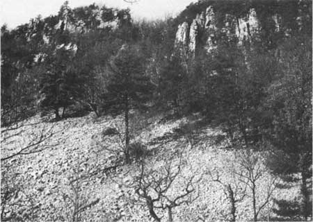
| Figure 21. Quartzite beds at Blackrock in the southern section are the most resistant strata in the Hampton (Harpers) Formation and are responsible for extensive talus deposits on the eastern slopes of Trayfoot Mountain visible in the distance. |
Good exposures of the Hampton (Harpers) lithologies occur along Big Run and adjacent hollows (Plate 3, Figure 22). In the Big Run drainage basin the formation is about 1,800 feet (549 m) thick of which the upper 1,300 to 1,400 feet (396 to 427 m) is well exposed. Folding has affected this area less than most others in the park and though the beds are metamorphosed and have well-developed fracture cleavage, the fracturing has not obscured the bedding features. The drab, greenish-gray, very fine-grained metasandstones are evenly bedded with thicknesses that range up to about 3 feet (1 m). They are laterally extensive with little variation in thickness over several hundred feet of exposure, and are separated by very thin interbeds of drab, green phyllite (Figure 22). Bioturbation is readily visible in the smooth, water-worn exposures of silty sandstone in Big Run upstream from the steel bridge near the mouth of Big Run hollow. Faint outlines of cylindrical burrows and disconnected or warped-bedding laminations are visible but are somewhat distorted by fracture cleavage. Sinuous trails, probably made by ancient surface-feeding organisms, occur sparsely on the upper surfaces of some sandstone beds exposed in the cliffs along Big Run (Figure 22). The drab, greenish-gray metasandstones locally contain short, vertical, poorly formed, cylindrical worm burrows similar to the Skolithos tubes found in the lighter hued sandstones but are 0.2 to 0.6 inches (0.5 to 1.5 cm) in diameter.
|
| Figure 22. Gently dipping metasandstone and phyllite in the upper portion of the Hampton (Harpers) Formation on Big Run approximately 3 miles (5 km) north of Big Run Shelter (Plate 3). |
The lower third of the formation is poorly exposed in the park, but appears to be mainly laminated phyllite with a few thin beds of ferruginous sandstone or siltstone. Weathered exposures can be seen along Skyline Drive at Milepost 79, and 0.5 mile (0.8 km) north of Sawmill Run Overlook (Plate 3).
Quartzite bodies in the Hampton attain maximum thickness and form widespread but thin, sheet-like bodies of talus down-slope from the outcrops (Figure 26). The most extensive quartzite bed, essentially identical to the quartzites of the overlying Erwin Formation, is nearly 80 feet (24 m) thick and occurs within a sequence of drab, grayish-green, fine-grained sandstones about 800 feet (245 m) below the top of the Hampton. It is well-exposed at Black Rock (Figure 21), in Big Run, and on the trail to Calvary Rocks from Skyline Drive (Plate 3) but thins and is apparently absent to the northeast and southwest of these areas.
Erwin (Antietam) Formation
The Erwin (Antietam) Formation is characterized by thick-bedded, very resistant, light-gray to white quartzite beds that form sharp peaks, flatirons, and many of the higher ridges among the western foothills of the Blue Ridge. The formation is present almost continuously from Bentonville (Plate 1) to Waynesboro (Plate 3). The Erwin quartzite ledges may be seen from many points along Skyline Drive. On the west side of the Blue Ridge in the southern section, cliff-forming, white quartzite beds, some as much as 75 feet (23 m) thick, may be visually traced from ridge to ridge and through flextures or small folds on the ridge slopes. Below the ledges extensive boulder fields of white quartzite blocks cover the uppermost beds of the underlying Hampton Formation (Figure 23).
|
| Figure 23. Erwin (Antietam) quartzite ledges and talus on the southwest side of Big Run. The pinnacle or column-like forms are produced by differential weathering along near-vertical fractures (joints) and subsequent collapse of the broken and weathered zones. |
The Erwin Formation is almost 1,000 feet (305 m) thick along Big Run (Plate 3) and probably is not less than 700 feet (213 m) thick in other park areas. It has been divided into an upper and a lower member that are shown separately on Plates 1-3. The lower member consists of three to five very resistant quartzite ledges with an aggregate thickness of 400 to 850 feet (122 to 259 m) separated by intervals of less-resistant strata, generally friable metasandstone or interbedded phyllite similar to the phyllite in the Hampton Formation. The less-resistant strata are largely concealed beneath the talus of adjacent quartzite ledges but can be seen along Big Run (Plate 3), on Piney Mountain above Ugly Run (Plate 2), and along Overall Run northwest of Matthews Arm Campground (Plate 1). The quartzite is thick-bedded, cross-laminated, light bluish-gray. to nearly white, vitreous, medium-grained, metamorphosed quartz sandstone (R-4419). Skolithos tubes are locally abundant in the lower ledges, with tube lengths approaching 3 feet (1 m) in the thicker beds. Where large populations of the longer tubes are present, the quartzites may exhibit a strong linear shear fabric along fracture surfaces paralleling the tubes (Figure 24). White quartzite beds with Skolithos tubes are well displayed along most of the Erwin outcrop belt, although exposures can be reached only by foot trail from Skyline Drive. The most accessible exposures are along fire trails that cross the lower ledges of the formation on Turk Mountain, Rocky Mount (Figure 25), and Calvary Rocks (Figure 24, Plate 3).

|
| Figure 24. Skolithos in an Erwin (Antietam) quartzite bed near Calvary Rocks in the southern section. The fossil "tubes" or burrows are commonly exposed on a fracture surface, such as this, because they seem to provide a directional weakness along which the otherwise homogeneous quartzite beds tend to break. |
|
| Figure 25. Erwin (Antietam) quartzite and extensive talus deposits along the trail crossing Rocky Mount. |
The upper member of the Erwin Formation contains only a few thin quartzite beds and is very poorly exposed in the park. The lower boundary of this member is placed at the top of the series of ridge-forming quartzite ledges that form the lower member. The upper contact of the Erwin with the overlying Cambrian carbonate rocks is covered by talus or deeply weathered residual material and is not visible in or near the park.
Manganese and iron exporation pits and mines have been opened along the top of the upper member and have exposed light, varicolored, phyllitic clay (R-4401) and sandstone. These deeply weathered rocks are well exposed in the north end of the pits at the abandoned Crimora mine and may be part of the upper member or a transitional sequence between the upper member and overlying Cambrian carbonate rocks.
TRIASSIC SYSTEM
Diabase Dikes
Dense, greenish-black, coarsly crystalline diabase dikes of Triassic age have intruded rocks of the Blue Ridge in the southern and central sections (Plates 2, 3). They trend a few degrees west of north, and are essentially vertical. Exposures are rare except in roadcuts, but the trace of the dikes is marked by spheroidal diabase boulders on the surface and in the soil or by sharp linear hollows and low gaps where they extend across the Blue Ridge crest. Sharp linear depressions are common throughout the park and many may mark the trace of unseen diabase intrusions. These dikes are distinguished from the greenstone dikes of Precambrian age by their greater density and hardness, and by their lack of cleavage. One diabase dike only a few inches thick is exposed on Skyline Drive in the south end of the roadcut approximately 0.25 mile (0.40 km) south of Rocky Top Overlook (Plate 3).
SURFICIAL DEPOSITS
Although bedrock exposure in the Blue Ridge is locally extensive and sometimes spectacular, all except a very small percentage of the surface is covered by a mantle of soil; coarse, weathered, rock debris; boulder deposits; or alluvium. Most of the land surface is notably rocky. Boulder-strewn fields and woodlands are characteristic of the gently sloping upper mountain surfaces particularly where Catoctin basalt is present. Steeper slopes are commonly covered by talus, generally broad deposits of large angular quartzite, or basalt blocks that blanket the slopes for several hundred feet below cliffs or ledges of the resistant rock. These deposits are prevalent on slopes below the outcrop of Erwin or Hampton quartzites or Catoctin basalt and also have formed on very steep slopes underlain by the Pedlar or Old Rag formations. Much of the quartzite talus is devoid of vegetation or supports only a few small trees (Figure 23) and from a distance has the appearance of a white rock-slide. The slopes covered by basalt talus are not as extensive or as apparent from a distance because they generally are well forested and have the beginning of a soil cover developing between the large, gray, basalt blocks. Granitic rock talus, such as seen on the north slope of Old Rag Mountain, differs from talus formed from the layered rocks mainly in the size range of the granitic boulders that form the deposit. Granite blocks range up to house size but are generally much smaller, the size range being governed by the spacing of fractures in the granite body (Figure 8). Talus formed from the layered rocks contains comparatively uniform size blocks as the rocks tend to break along bedding as well as across it (Figure 26). As the bedding surfaces are generally spaced a few inches to a few feet apart they limit the length of one dimension of the block. Closely spaced joints and cleavage present in all the layered rocks limit the other two dimensions of the block so that blocks more than a few feet square rarely occur (Figure 21).

|
| Figure 26. Upslope view of lichen-covered quartzite blocks in the talus deposit at Black Rock (Plate 3). The blocks are very regular in size and shape, being roughly rectilinear and 2.0 to 4.0 feet (0.6 to 1.2 m) across, a condition controlled by the uniformity of thickness of the Hampton quartzite beds at this location. |
Fertile and locally deep but stony soils have formed on the more soluble plutonic and volcanic rocks but only very thin sandy or shaly soils are present on the metasedimentary rocks. The difference in these soils is directly expressed in the size and species of trees growing on them. The difference is most apparent along the boundary between the Catoctin and Weverton formations where the forest cover on both formations can be seen together. The forest on the soils of the Catoctin Formation has a diversity of tree types, sizes, and shapes with the trees being generally larger than those on the Weverton Formation which exhibit a uniformity of size, height, and shape broken only by a few scattered pines. The difference is most noticeable in October when the fall colors are at their peak brightness. Then, the entire forest area underlain by the metasedimentary rocks takes on a drab yellow-brown hue while the colors in the forest on the volcanic and plutonic rocks are bright reds, oranges, and yellows with many trees still partly or wholy green. The sharp color contrast probably reflects differences in soil moisture content as much or more than species differences between trees in the two rock types.
Narrow, discontinuous flood plains have developed along the lower reaches of many streams flowing from the Blue Ridge. They are covered with deposits of sand, cobbles, and boulders of resistant rock (granite, basalt, or quartzite) to depths as much as 5 feet (2 m) except in the stream channels where bedrock is commonly exposed. All along the west foot of the Blue Ridge and locally along the east foot, thick alluvial fans have been spread over the lowlands by these streams, covering bedrock for distances of up to 2 miles (3 km) from the mountains. Between Elkton and Waynesboro (Plate 3) the thick coalescing alluvial fans form an unbroken, westward-sloping plain between the Blue Ridge foot and the terraces along the Shenandoah River. North of Elkton the fans have been incised by crosscutting streams or removed by the encroachment of the Shenandoah River and are now absent or locally discontinuous. Quartzite, metabasalt, and granite boulders, cobbles, and pebbles in a sand and clay matrix make up the rock material in the fans. Stratification can be seen where roadcuts have exposed the poorly consolidated material. Although portions of the fan-covered areas can be seen from Skyline Drive they are best viewed from along U. S. Highway 340 between Elkton and Waynesboro.
| <<< Previous | <<< Contents >>> | Next >>> |
state/va/vdmr-bul-86/sec2.htm
Last Updated: 28-Nov-2007