
|
Washington Department of Natural Resources Geology and Earth Resources Division Information Circular 90 Flood Basalts and Glacier Floods: Roadside Geology of Parts of Walla Walla, Franklin, and Columbia Counties, Washington Robert J. Carson and Kevin R. Pogue |
Road Logs
PART 1 - WALLA WALLA TO PALOUSE FALLS
| Miles | |||||||
| 0.0 |
Proceed north out of Whitman College's parking lot and turn right (east) on Isaacs Avenue (elevation 990 ft). (The route for all five segments of this trip is shown in Figure 7 and on the back cover.) | ||||||
| |||||||
| 0.3 |
At the stoplight, turn left (north) onto Clinton Avenue. | ||||||
| 0.9 |
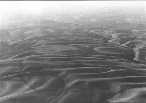
At the stop sign, turn right (east) on U.S. Highway 12. In the distance, the Palouse Hills (Fig. 8) are to the left (north), the Blue Mountain anticline to the southeast. The highest point in the Blue Mountains is Oregon Butte, which, at 6,387 ft, was not high enough to be glaciated. As you drive east, note the low surface, or flood plain, along Mill Creek to the right (south) and the higher surface or terrace to the north. The high surface is probably the floor of the intermittent lake caused when Missoula floods were temporarily backed up (or hydraulically dammed) at Wallula Gap. | ||||||
| |||||||
| 2.9 |
Walla Walla Airport (elevation 1,196 ft) is to the north on the high surface. | ||||||
| 5.6 to 7.0 |
You are crossing a small part of the Palouse Hills. The roadcuts are in Quaternary loess. At least one caliche rich paleosol (ancient, buried soil) can be seen. During the Quaternary, episodes of loess (windblown silt) deposition alternated with periods of relative stability or reduced rates of deposition. Soils formed during the stable periods. When the climate was warm and dry, a layer or crust of calcium carbonate called caliche accumulated in the soils. | ||||||
| 8.0 |
Loess over lava of the Frenchman Springs Member of the Wanapum Basalt (Columbia River Basalt Group), about 15.3 Ma. | ||||||
| 10.2 |
Enter Dixie (elevation 1,547 ft). | ||||||
| 10.8 |
Leave Dixie (old high school to the right, or south). Roadcuts for the next 2 mi expose Quaternary loess over Miocene basalt. | ||||||
| 12.8 |
Drainage divide between Walla Walla and Touchet Rivers (elevation 1,914 ft) (Fig. 9). The road is on thick loess with several caliche-rich paleosols. From here to past Dayton, green fields are mostly growing winter and (or) spring wheat; tan/yellow/brown fields are wheat ready for harvest, wheat stubble after harvest, or fields with various degrees of tillage. The mean annual precipitation in Walla Walla County ranges from about 20 cm at the western edge in the Pasco Basin to about 100cm in the higher parts of the Blue Mountains. To get a wheat crop every year requires about 50 cm of precipitation. In areas with less moisture, the field may lie fallow every other year, storing moisture for the next year's wheat crop. | ||||||
| |||||||
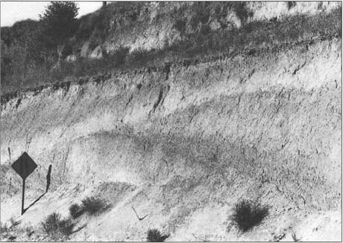
| 18.2 |
Stripcropping of hillsides is prominent from here to just past Dayton (Fig. 10). The loess of the Palouse Hills is highly erodible soil. Soil losses of 0.3 to 0.4 cm/yr are common, and erosion of 1.4 to 2.7 cm/yr occurs on steep slopes (Higgins and others, 1989, p. 887). Much of the sediment is deposited in the reservoirs along the Snake and Columbia Rivers. Factors influencing soil loss include soil erodibility, rainfall, slope, length of slope, vegetation, and cultivation techniques. Strip cropping (commonly alternating wheat crops and fallow fields) effectively reduces the length of bare slope, thereby reducing erosion. | ||||||
| |||||||
| 19.6 |
Enter Waitsburg (elevation 1,268 ft). | ||||||
| 20.2 |
Turn right (east), continuing on U.S. Highway 12. Then cross the Touchet River; note the artificial levees designed to reduce flooding of Waitsburg, which lies on the Touchet River's flood plain. Most historic floods in this area are caused by rain-on-snow events or summer thunderstorms. | ||||||
| 21.0 |
Leave Waitsburg. You are driving across the flood plain of the Touchet River. | ||||||
| 22.5 |
Turn left (north) at the grain elevators; cross the railroad tracks. | ||||||
| 22.6 |
Turn left (west) on the paved secondary road along the north edge of the Touchet Valley. | ||||||
| 23.2 |
STOP 1: Quarry in a tiered or banded lava flow of the Frenchman Springs Member (Wanapum Basalt) (Fig. 11). "Are tiers the result of some process completely internal to a ponded flow and related to its cooling history, or does each tier record a separate pulse of lava into a gradually deepening pond? In other words, is a tiered flow a single or multiple-flow cooling unit?" (Swanson and Wright, 1981, p. 20). McDuffie and Winter (1988) studied this banded lava flow: "There are no significant compositional difference between the bands. However, there is a consistent pattern of increasing mesostasis in the center of each band, suggesting a relationship to cooling. Platy fracture horizons and curves in the columnar joints are considered to be related to propagation of the joints. The regular spacing of the bands suggests a cyclic event that varies the cooling rate, such as variations in seasonal precipitation." The causes of bands in some lava flows of the Columbia River Basalt Group have not been clarified. Vesiculation (formation of gas-bubble cavities in a volcanic rock) and (or) jointing may influence the bands. For studies of vesicles and joints in Columbia River basalts, see papers by McMillan and others (1989) and Long and Wood (1986), respectively. Turn around and return to U.S. Highway 12. | ||||||
| |||||||
| 23.5 |
Enter Columbia County. | ||||||
| 23.9 |
Turn left (west) on U.S. Highway 12. | ||||||
| 25.5 |
Cross the Touchet River. | ||||||
| 25.9 |
Lewis and Clark Trail State Park (rest area). | ||||||
| 30.2 |
Enter Dayton (elevation 1,613 ft). The Lewis and Clark Expedition camped just east of town in May 1806 (Majors, 1975). | ||||||
| 30.9 |
Cross the Touchet River. More than once, dams have been proposed for the North Fork Touchet River upstream of Dayton. While an earth-rock dam 8 km upstream of Dayton was being considered in the mid 1970s, the Teton Dam in eastern Idaho was under construction. The dam on the Teton River was an earth-rock dam, and it failed while the reservoir was first being filled. A huge hole developed adjacent to the right abutment of the dam in June 1976. The right side of the dam was destroyed, and the ensuing flood inundated four towns downvalley and killed 11 people (Reisner, 1986, p. 422). The Teton dam failure led the citizens of Columbia County to decide that they did not need a similar dam near Dayton. | ||||||
| 31.9 |
Leave Dayton. The quarry on the right (east) side of the road is in a banded Frenchman Springs (Wanapum Basalt) flow. The same banded lava flow is exposed at Stop 1. | ||||||
| 37.2 |
Divide between drainage basins of the Touchet and Tucannon Rivers. Both rivers originate in the Blue Mountains, but the Tucannon River is a tributary of the Snake River, whereas the Touchet River flows into the Walla Walla River. The high bluffs at the divide are loess beds that contain paleosols. On a clear day, on the northeast horizon you can see conical Steptoe Butte approximately 100 km to the northeast. Steptoe Butte (elevation 3,612 ft) rises about 300 m above the surrounding Miocene Columbia River basalt flows and the overlying Pleistocene loess (Fig. 12). Steptoe Butte consists of quartzite that probably correlates with the Precambrian Belt or Windermere Supergroup and is essentially a western outlier of the Rocky Mountains of Idaho. | ||||||
| |||||||
| 39.7 |
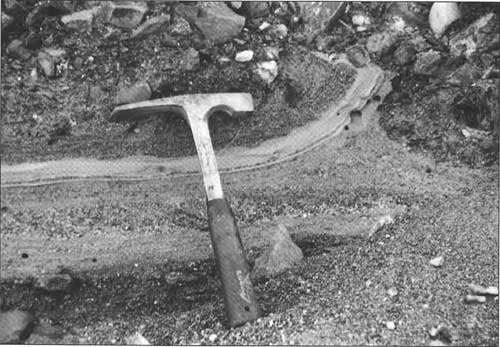
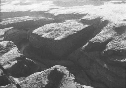
STOP 2: Roadcuts on U.S. Highway 12. Beware of traffic! The contact between the Grande Ronde and Wanapum Basalts is exposed on the west side of the highway (Fig. 13). This 15.6-m.y.-old contact is called the Vantage horizon. This is an unconformable contact, meaning that there was a significant period of time between the eruption of the flows below and above the contact. The pause in volcanism lasted about 100,000 years (Carson and others, 1987). In the western part of the Columbia Plateau, the sediments that were deposited during this time are called the Vantage Member of the Ellensburg Formation. Here, weathering produced the reddish oxidized zone, which is an incipient residual soil developed on the uppermost lava flow of the Grande Ronde Basalt (Swanson and Wright, 1981). Above the contact is the lowermost flow of the Frenchman Springs Member of the Wanapum Basalt (Swanson and others, 1980). The climate here was warmer and moister during the Miocene. Evidence includes the residual, lateritic soil and many species of trees preserved as petrified wood at the Vantage interval at the Ginkgo Petrified Forest State Park near Vantage (Carson and others, 1987). The lateritic soil (like laterites today) is composed mostly of iron and aluminum oxides and hydroxides. On the east side of the highway are both subaerial and subaqueous portions of a basalt flow (Frenchman Springs Member), indicating that here the lava flow entered a lake or stream. The lower part contains rounded blobs of lava, or pillows, that formed as the lava came in contact with the water (Fig. 14). Individual pillows exhibit radial cooling joints. The glassy rinds on the margins of the pillows indicate that the water quickly cooled the outside of the pillow before any crystallization could occur. The lava between the pillows underwent phreatic brecciation; that is, when the hot lava came in contact with cool water, the quick chilling caused small steam explosions that shattered the cooling lava into angular, glassy fragments called hyaloclastite. The hyaloclastite was once black, but a reaction between the water and the brecciated debris altered the basaltic glass to orange palagonite (Carson and others, 1987, p. 361-362). The upper part of the flow was not affected by the water; it has polygonal columns that formed during cooling and contraction. The weathered top of the Grande Ronde basalt flow is a zone of weakness in the roadcut along which rock falls may be common. The highway department has sprayed concrete (referred to as dental work) and installed wire mesh to keep the mass-wasting products from falling on the road. Above the basalt is the 'Palouse loess' or Palouse Formation (Fig. 13). The silty sediment was carried by winds from sources to the southwest of the Palouse Hills. Four morphologically distinct units are recognized in the Palouse loess; these range in age from mid- or early-Pleistocene to Holocene. At least three of these units are complex, consisting of two or more depositional phases indicating pauses in sedimentation (Fryxell and Cook, 1964). Busacca and McDonald (1994) have worked on the stratigraphy of the Quaternary loess in the Palouse Hills, using buried caliche-rich soils and volcanic ash layers to make correlations. Notice that the silty soil is thin over the basalt highs and that the loess fills lows on the pre-loess topography. After the basalts erupted in the Miocene, erosion gradually created an undulating land surface with relief of a few meters. Quaternary loess covered the surface, but it is thinner over the basalt ridges or hills and thicker in the swales or valleys. Continue north on U.S. Highway 12. | ||||||
| |||||||
| 44.4 |
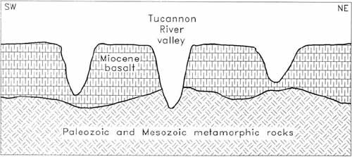
Cross the Tucannon River. In this area of steep topography and thin soils, the chief land use is grazing. Approximately 40 to 50 km up the Tucannon River are exposures of the Baker exotic terrane (ribbon chert, greenstone, argillite, minor marble and amphibolite) (Dave Blackwell, formerly with Whitman College, written common., 1992; Swanson and others, 1980). Exotic terranes are fragments of old continents or oceanic floor that were accreted to western North America. Accretion in this region occurred about 100 m.y. ago and was accompanied by mountain building. The eroded remnants of the mountains were covered by the Columbia River basalts about 17-15 m.y. ago. Later, the Blue Mountains (to the southeast) were uplifted and eroded. The Tucannon River cut through the basalts and reached some of the buried mountains of the 'Baker terrane' (Fig. 15). | ||||||
| |||||||
| 46.1 |
Turn left (west) toward Starbuck on State Route 261 (elevation 936 ft). Here at Delaney, the roadcuts reveal late Pleistocene Touchet Beds, slackwater sediments deposited by the jökulhlaups from glacial Lake Missoula. Each bed or rhythmite is graded and is believed to represent a separate flood from western Montana (Waitt, 1980). The floods rushed up the Tucannon River from the Snake River, carrying icebergs. When the floodwaters receded, the icebergs were grounded. They then melted, depositing whatever rocks they were carrying as erratics. The Touchet Beds are coarser and thicker downvalley (toward the source). For a discussion of the rhythmites here at Delaney, see Waitt and others (1994, p. 57-59). | ||||||
| 46.2 |
As we proceed down the Tucannon River valley, we will try to unravel the geologic history of cut and fill. The late Cenozoic uplift of the Blue Mountains caused the Tucannon River to deeply incise the basalts. The late Pleistocene Touchet Beds partly filled this valley. The Tucannon River then partially eroded the Touchet Beds and filled the new valley with silts derived from erosion of loess and Touchet Beds. This valley filling event is at least partly early Holocene because the silts locally include Mazama ash (6,845 ± 50 years old; Bacon, 1983). The ash washed down into the valley from the surrounding hills. Most recently (perhaps due to agricultural activity in the past century), the Holocene fill has been incised again by the Tucannon River. | ||||||
| 48.7 |
In this general vicinity, particularly on the south side of the Tucannon valley, are small-scale landforms whose origin has been vigorously debated. They have been called steps, terracettes, and cattle tracks (Fig. 16). Similar features have been called sheep-tracks or cattle terraces (Sharpe, 1938, p. 70-74). They even look somewhat like the cold-climate landforms called steps by Washburn (1956, p. 833-836). Are they purely geologic, due to mass wasting and possibly cold climate? Are they purely biologic, having been cut by domestic and (or) hoofed mammals? Are the terracettes produced by a combination of factors? Sharpe (1938, p. 70-74) reviewed their origin and stated (p. 71) that there are all gradations from true animal paths that have had no surface movement to miniature slump or fault blocks in which animals have played no role. | ||||||
| |||||||
| 53.3 |
Enter Starbuck (elevation 645 ft). In the 1960s, this was a boom town during construction of Little Goose Dam about 12 km to the northeast on the Snake River (Miklancic, 1989b). | ||||||
| 54.3 |
Leave Starbuck. | ||||||
| 54.7 |
Road to the right (northeast) leads to Little Goose Dam. Continue northwest (straight) on State Route 261. | ||||||
| 54.9 to 55.1 |
STOP 3: Roadcuts in Touchet Beds. Except that they are coarser than normal, these are typical Touchet Beds, the slackwater sediments deposited by the Missoula floods (Figs. 17, 18, 19). At this stop, the Touchet Beds are coarse because they were deposited near the mouth of the Tucannon River; they are transitional between gravel bars on the Snake River and more typical (finer grained) Touchet Beds just upvalley of Starbuck. The Touchet Beds commonly exhibit rhythmites that have graded bedding and are cross-cut by clastic dikes (Fig. 19). There have been at least eight origins proposed for the clastic dikes (Carson and others, 1978). An ideal Touchet bed here has the following vertical sequence (Baker, 1973b, p. 43): (1) basal layer of poorly sorted, angular flood gravel, (2) structureless coarse sand and granules, (3) horizontally stratified medium and fine sand (4) current ripple bedding in the uppermost fine sands and lowermost coarse silts, and (5) parallel lamination in the medium and fine silts. Smith (1993) restudied the Touchet Beds in the Tucannon River valley. He determined that most of the flood sediments were deposited by energetic surges (6 m/sec) of the floods from glacial Lake Missoula. Smith (1993, p. 88) defined a flood sequence as "one or more beds that are bounded by nonflood sediments, horizons of bioturbation, or desiccation structures, but that lack such features between beds and are thus inferred to record deposition during a single flood." This stop is at Smith's (1993, p. 92-94) section 3, that is actually a composite of four sections that he measured over a distance of 400 m. According to Smith (1993, p. 92): "At least 35 flood beds, comprising 9 flood sequences, appear in this outcrop. Lateral variations are extreme, as a consequence of erosion between, or during, floods, and no single vertical section can accurately reflect the flood stratigraphy." Many sedimentary structures are present; according to Smith (1993) most of the paleocurrent indicators (such as cross-beds) indicate downvalley flow, but there is some evidence for upvalley currents. Waitt and others (1994) disagreed with some of the interpretations of Baker (1973b) and Smith (1993). Waitt and others (1994, p. 57) described a rhythmite at this location as having: (1) a basal basaltic pebble gravel with upvalley-directed foreset beds, (2) a middle portion of laminated sand revealing evidence of upvalley-directed currents, and (3) an upper portion of very fine sand to silt. Waitt and others (1994) counted 10 or perhaps 11 flood-laid beds here. Continue northwest on State Route 261. | ||||||
| |||||||
| 56.3 |
Cross the Tucannon River. | ||||||
| 57.2 |
Eastward from the road are a marsh, a gravel bar, and an intracanyon flow (Figs. 20-23). The marsh covers the top of the delta deposited by the Tucannon River (Fig. 2). Construction of Lower Monumental Dam (in the 1960s) about 30 km down stream drowned the lowermost Tucannon valley. The delta formed where the Tucannon River dropped its sediments in the ponded reach of the river. This gravel bar is an eddy bar related to the Missoula floods. As jökulhlaups surged up the Snake River, gravels were deposited by the floods in an eddy at the mouth of the Tucannon River. The intracanyon flow is the Lower Monumental Member of the Saddle Mountains Basalt. The Lower Monumental flow, at 6 m.y. old, is the youngest of all Columbia River basalts. It "occupies a broad valley eroded through the Wanapum Basalt into the Grande Ronde Basalt..." (Swanson and Wright, 1981, p. 20). Just to the east of the Lower Monumental flow is an intracanyon flow of the Pomona Member (12 m.y. old) of the Saddle Mountains Basalt (Swanson and others, 1980). | ||||||
| |||||||
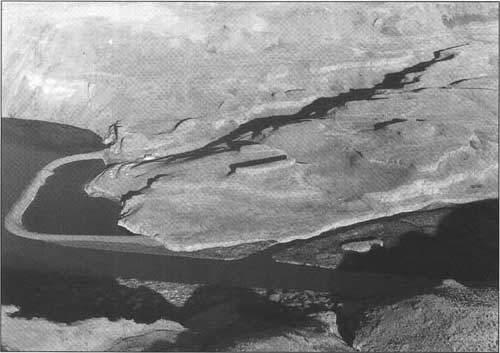
| 57.8 |
Mouth of the Tucannon River. On the north bank of the Snake River is a huge Missoula floods gravel bar, that Bretz called "great bar" according to Waitt and others (1994) (Fig. 21). Lewis and Clark 'discovered' the mouth of the Tucannon River in October 1804 and called it 'Kimooenim Creek". Col. George Wright constructed a temporary log fort here in August 1858; that site is probably now in the reservoir (Majors, 1975). | ||||||
| |||||||
| 58.1 |
Start up a topographic feature locally called Midcanyon bar (Figs. 21 and 23) that is composed of gravel deposited by Missoula floods. This bar is covered by giant ripples whose asymmetry indicates flow eastward up the Snake River (Webster and others, 1976). Just to the left (southwest) above the railroad tracks is a banded (or tiered) flow of the Grande Ronde Basalt (Swanson and Wright, 1981). | ||||||
| |||||||
| |||||||
| 60.5 |
Entrance to Lyons Ferry Marina. Continue northwest on State Route 261. | ||||||
| 60.8 |
Leave Midcanyon bar; cross the Snake River. Enter Franklin County. To the north is the mouth of the Palouse River. "Upstream along the Palouse River, approximately 2 miles from this point, was the Marmes Rockshelter. The Marmes Rockshelter archaeological site received worldwide attention in the spring of 1968 when human remains were discovered in situ 14 feet beneath the surface of the modern flood plain. These remains were established reliably as being at least 10,000 years old—[then] the oldest well-documented human remains in the New World. Numerous artifacts, cultural features and animal bones were associated directly with the human remains. Because the site was to be flooded by the impoundment behind Lower Monumental Dam in less than a year, emergency salvage excavations were begun in May 1968 and continued through February 1969 when the reservoir and the site were flooded. Marmes Rockshelter contains an unparalleled stratigraphic and cultural record spanning more than 10,000 years. It serves as a basis for comparison with most other sites in the Columbia Basin" (Webster and others, 1976, p. 18). See reports by Fryxell and others (1968) and by Sheppard and others (1984) for more information about the Marmes Rockshelter (Figs. 21 and 24). | ||||||
| |||||||
| 61.4 |
Entrance to Lyons Ferry State Park (rest area). | ||||||
| 61.7 |
STOP 4: Park on the left (southwest) side of the road under the railroad bridge near the junction of the Palouse and Snake Rivers. (See Fig. 21.) The ancestral Palouse River ran west to the Pasco Basin down what is now called Washtucna Coulee (Fig. 6). Here may have been the mouth of a small south-flowing stream dissecting the east-west ridge between the Snake River and the ancestral Palouse River. About 25 of the Missoula floods overtopped the ridge, cutting a broad north-to-south path including a narrow canyon now occupied by the modern Palouse River (Smith, 1993, p. 95). As each Missoula flood rushed south across the divide and down the original south-flowing stream, the water hit the basalt cliffs on the south side of the Snake River. Some of the floodwaters rushed west down the Snake River, depositing No-name gravel bar (Fig. 21). "The surface of the bar is covered with giant current ripples whose asymmetry clearly indicates flood flow down the Snake Valley" (Webster and others, 1976, p. 17). The rest of the floodwaters rushed east up the Snake River, depositing Midcanyon Bar. For details about gravel bars and current directions in this area, see Bretz and others (1956, p. 1020-1024), Bretz (1959, p. 41-46) and Waitt and others (1994, p. 55-58). Many Missoula floods extended up the Snake River at least as far as Lewiston, Idaho (130 km upriver). The evidence for this is 20 or 21 Touchet Beds overlying Tammany Bar (located upstream from Lewiston on the Snake River); this gravel bar was deposited by the late Pleistocene flood from pluvial Lake Bonneville (Waitt, 1983, 1985) (Fig. 5). Pluvial Lake Bonneville was a large freshwater lake that repeatedly formed in the general vicinity of its salty remnant, the Great Salt Lake of Utah (that has no outlet). Pluvial periods were somewhat cooler than today, and there was more precipitation and less evaporation. In the western United States, pluvial periods coincided with glaciations; that is, pluvial lakes were most extensive at about the same time as the maximum advances of the glaciers. Although Lake Bonneville formed during many pluvial periods, there is no evidence that it overflowed before about 15,000 years ago (Scott and others, 1983). The initial overflow from this huge lake caused rapid downcutting of about 100 m at Red Rock Pass in southeastern Idaho. The catastrophic Bonneville flood took place when much of the lake quickly drained, sending enormous volumes of water west and north across Idaho. For more information about the Bonneville floods, see reports by Malde (1968), Malde and O'Connor (1993), and Jarrett and Malde (1987). The bedrock geology from here to the turnoff to Palouse Falls State Park consists of four units of the Columbia River Basalt Group. From river level to the approximate elevation of this stop are the upper flows of normal magnetic polarity (N2) of the Grande Ronde Basalt (Fig. 3). Overlying the Grande Ronde Basalt are flows of (from oldest to youngest) the Frenchman Springs Member, the Roza Member, and the Priest Rapids Member of the Wanapum Basalt (Swanson and others, 1980). Continue north on State Route 261. You soon enter scabland topography (Fig. 25). The area of eastern Washington eroded when glacial Lake Missoula's ice dam failed repeatedly is called the 'Channeled Scabland'. This term was first used in the early 1920s by J Harlen Bretz (e.g., Bretz, 1923, 1928c). The floods cut channels, called 'coulees', many with scour depressions. Most of the coulees are dry except for lakes in some scour depressions. The remnants of basalt flows left after the eroding floods drained away are called 'scabs'. Bretz discovered half a dozen erosional features or characteristics of the Missoula floods (summarized in Allen and others, 1986, p. 98):
Baker (1973a,b, 1978) classified the erosional and depositional landforms in the Channeled Scabland and described the processes by which the Missoula floods formed these features. | ||||||
| |||||||
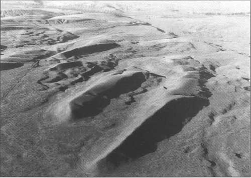
| 61.9 |
Small dune field to the west. | ||||||
| 62.5 |
Small dune field to the east. | ||||||
| 64.0 |
Loess 'islands' (Fig. 26) to the southwest. The long loess hills are aligned northeast and cover much of the broad path that the floods cut between the ancestral Palouse River and the Snake River. Bretz and others (1956) believed these hills were fluvially eroded; they thought the break-in-slope at the basalt/loess contact was the high-water mark. On the basis of high-water mark reconstruction, Baker (1973b) believed that the hills were not islands, that they were eroded subfluvially. Baker (1973a) calculated that water velocities averaged about 14 m/sec where flood waters were 30-60 m deep. | ||||||
| |||||||
| 66.2 |
Turn right (northeast) to Palouse Falls State Park (elevation of the road intersection 1,281 ft). This is near the middle of a 12-km-wide flood channel, part of the Cheney-Palouse tract that stretches from Spokane to the Pasco Basin via Palouse Falls. This is the easternmost of various channels that carried floodwaters across eastern Washington. (Grand Coulee was another major channel to the west; see Fig. 6). The channel displays canyons cut along fracture sets, basalt scabs, and elongate loess 'islands'. Most of the basalt boulders from here to Palouse Falls were bed load of the Missoula floods. Imagine the force of water (or discharge) needed to move these large rocks! Lava flows between here and Palouse Falls are of the Roza and Frenchman Springs Members of the Wanapum Basalt. On both sides of the road are tilled firebreaks. | ||||||
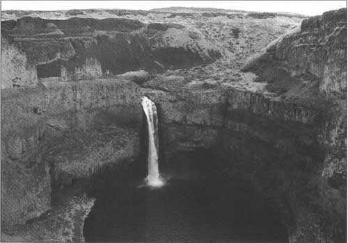
| 69.0 |
STOP 5: Palouse Falls (Figs. 21 and 27). The falls are 56 m high; the canyon below the falls is 377 ft (115 m) deep. There are four lava flows exposed in the canyon walls, and more in the distance (Figs. 28 and 29 and cover photo). The upper flow in the canyon walls is the Ginkgo flow of the Frenchman Springs Member (Wanapum Basalt; about 15.5 Ma) (S. P. Reidel, Westinghouse Hanford Co., oral commun., 1993). The thick upper flow is chiefly an entablature of small irregular columns; its basal colonnade has been eroded into a 'picket fence' or 'organ pipes' just above and to the left of the falls. The lip of the falls is carved into the second flow down, the Palouse Falls flow of the Frenchman Springs Member (Swanson and Wright, 1981). The two lowest flows are part of the Sentinel Bluffs unit of the Grande Ronde Basalt (S. P. Reidel, oral commun., 1993). The third flow down has an easily distinguished upper entablature and a lower colonnade. The lowest flow is thick and extends below the water level of Palouse Falls' deep plunge pool. Between the Palouse Falls flow and the Ginkgo flow is an unnamed interbed that is exposed just upriver from Palouse Falls (see Fig. 3). It appears to be the filling of an ancient shallow lake. The 1-m-thick sediments include ash, peat, and sand (Swanson and Wright, 1976). Notice the angular drainage pattern (Fig. 27) in this area. The Palouse River and other flood-excavated canyons follow fracture sets (faults or joints) striking approximately N50°E N20°W, and N55°W. In 1984, the Franklin County Public Utilities District proposed that a 30-m-high concrete dam be constructed just upstream of Palouse Falls. The 9-km-long reservoir would have supplied water to conduits leading 0.6 km downstream to a powerhouse. This hydroelectric facility would have provided as much as one-third of the power used by the county. However, the majority of the ratepayers did not want the PUD to fund a feasibility study, so the commissioners decided against the dam. (Articles about this dam can be found in the April 20 and October 21, 1984, editions of the Walla Walla Union-Bulletin.) Return to State Route 261 to start the next leg of the trip. | ||||||
| |||||||


| <<< Previous | <<< Contents >>> | Next >>> |
state/wa/1996-90/part1.htm
Last Updated: 05-Aug-2011