
|
Washington Department of Natural Resources Geology and Earth Resources Division Information Circular 90 Flood Basalts and Glacier Floods: Roadside Geology of Parts of Walla Walla, Franklin, and Columbia Counties, Washington Robert J. Carson and Kevin R. Pogue |
GENERAL GEOLOGY OF SOUTHEASTERN WASHINGTON
This field trip guide covers the geology of some of the areas affected by two of the best documented catastrophic events in Earth's history: enormous basaltic lava flows that began to cover the land about 17 million years ago (Baksi, 1989) and giant glacier outburst floods (termed jökulhlaups) that started about 15,300 years ago (Waitt, 1985). These events are in large part responsible for the shape of the landscape of eastern Washington, where the Earth's youngest basalt plateau was swept by the largest documented floods in geologic history.
The Columbia Plateau is a physiographic province, an area that has somewhat similar rocks, landforms, soils, climate, and vegetation. Most of the rocks at the surface are basalt. Erosion and deposition by jökulhlaups shaped much of the surface, but streams have cut the land and left deposits as well, and wind has piled up sand dunes. The soils are thick on windblown silt (referred to as loess) and immature to nonexistent on sand, gravel, and basalt. The area receives as little as 20 cm annual precipitation and is considered arid. The natural vegetation is sagebrush shrubland and short-grass prairie (Hunt, 1974).
The Columbia Plateau is bordered on the north and east by the Rocky Mountains, on the south by the Basin and Range Province, and on the west by the Cascades (Fig. 1). The plateau province is divided into several physiographic sections. This field trip takes us through the central part of the Walla Walla Plateau section, adjacent to the northwest flank of the Blue Mountains section. On the Walla Walla Plateau, two of the largest rivers in North America meet: the Snake River, which originates on the Yellowstone Plateau, Wyoming, and the Columbia River, which starts at Columbia Lake in eastern British Columbia (Dietrich, 1995, p. 100).

|
| Figure 1. Physiographic map of the Columbia Plateau. (Modified from Hunt, 1974.) (click on image for a PDF version) |
The oldest rocks in the Blue Mountains are 'exotic terranes' composed of large fragments of continents and ocean floor. These range in age from about 350 million to about 200 million years and were accreted to western North America about 100 million years ago. These terranes were later intruded by Late Mesozoic granitic rocks and covered by Tertiary volcanic rocks. Most of the Miocene basalt flows (Fig. 2), which total as much as 3 km thick in the Walla Walla Plateau section, originated in the Blue Mountains section, where there were long fissures through which the lava poured. Magma in the fissures solidified to form dikes.

|
| Figure 2. Distribution of the Columbia River Basalt Group. (Modified from Tolan and Reidel, 1989.) (click on image for a PDF version) |
Magnetic Polarity
From time to time, at apparently random intervals, the Earth's magnetic field reverses. Currently, it is 'normal' or N, but about 800,000 years ago it was 'reversed' or R. There have been numerous polarity reversals over geologic time, and these reversals are recorded in the rocks. One of the physical properties that geologists use to distinguish the lava flows in the Columbia River Basalt Group is magnetic polarity. In Figure 3, this is indicated by the N and R in the Magnetic Polarity column. A few flows have transitional polarity (T), which means that the flow erupted during one of the pole reversals. Other flows erupted during a geomagnetic excursion (E). At these times, the paleomagnetic north or south poles were at intermediate to low latitudes. Transitions of polarity and geomagnetic excursions took place over fairly short periods, probably less than 10,000 years.

|
| Figure 3. Diagrammatic stratigraphic section for the central and southeastern Columbia Plateau. The Ellensburg Formation is composed of sediments overlying the Grande Ronde Basalt and underlying the Ringold Formation; it includes the named and unnamed interbeds. Members and flows not mentioned in the text are in lighter print. Flows in members not mentioned in the text are omitted from this figure. See p. 1 for an explanation of magnetic polarity. (Modified from Campbell and Reidel, 1991.) (click on image for a PDF version) |
Geologic Time
Geologists have special abbreviations for time: m.y. for million years, as in 'for 10 m.y.'; Ma for mega (million)-annum, used to indicate a point in geologic time or age, as in 'age estimate of 23 Ma'; and ka, for kilo (thousand)-annum, used to express ages of younger rock units. We will use these abbreviations from here on in this guide.
Columbia River Basalt Group
The Columbia River Basalt Group covers an area of about 163,700 km2 (Fig. 2) and has an estimated volume of 174,300 km3 (Tolan and others, 1989). More than 99 percent of the basalt was erupted between 17 and 14 m.y. ago (Swanson and Wright, 1978); eruptions occurred less often between 14 and 6 m.y. ago. Concurrent with volcanism were subsidence (for example, in the Pasco Basin), deformation (for example, in the Yakima Fold Belt shown on Fig. 2), erosion by rivers (many of whose valleys were later filled by intracanyon flows), and sedimentation (for example, the Ellensburg Formation). Figure 3 is a simplified stratigraphic column for the Columbia River Basalt Group and younger strata in the area traversed on this trip.
The ages of the lava flows that make up the Columbia River Basalt Group have been determined by radiometric dating, most commonly the potassium-argon (K-Ar) method. This technique is based on measuring the ratio of the radioactive isotopes 40K to 40Ar. Most igneous rocks contain some potassium; a fraction of a percent of this potassium is radioactive and decays at a known rate to argon. With time, there will be less radioactive potassium and more argon gas trapped in the rock. By making careful measurements of these chemical components, geologists can estimate the age of the rock. Baksi (1989) discusses K-Ar dating of the Grande Ronde Basalt, which erupted in about 1.3 m.y, between 16.9 and 15.6 Ma.
Tectonic Features
Anticlinal Ridges. The north-south compressional stresses of south-central Washington that created the anticlinal ridges (convex-upwards folds that include lava flows and any inter-bedded sedimentary rock), have existed from the mid-Miocene to the present (Reidel and others, 1992). According to Reidel and others (1992), the structural relief of some anticlines in the Yakima Fold Belt has increased by as much as 1,000 m in the past 10 m.y.
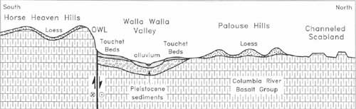
Olympic-Wallowa Lineament. A major tectonic feature in southeastern Washington is the northwest-trending Olympic-Wallowa lineament (commonly referred to as the OWL) (Figs. 2 and 4). In central and southeastern Washington, the OWL is marked by the aligned anticlinal ridges of the Yakima Fold Belt and faulted escarpments (Tolan and Reidel, 1989). Most of the fold belt structures plunge to the east and die out before reaching the field trip area, but the Horse Heaven Hills anticline continues east across southern Washington and intersects the larger Blue Mountains anticline in northern Oregon. Between the Columbia River and the Blue Mountains, the OWL is marked by a 200-m-high escarpment along the trace of the Wallula fault zone, a series of high-angle en echelon faults that display evidence for both dip-slip and strike-slip motion.
|
| Figure 4. General north-south cross section of the field trip area. OWL, Olympic-Wallowa lineament. The basalt flows are gently folded, particularly in the Horse Heaven Hills. (click on image for a PDF version) |
Hite Fault. The Hite fault intersects the Olympic-Wallowa lineament at approximately a right angle 35 km (22 mi) southeast of Walla Walla. This northeasterly striking fault can be traced to Lower Granite Dam on the Snake River (Tolan and Reidel, 1989). The Walla Walla area experienced an intensity VII (approximately Richter magnitude 6) earthquake on July 15, 1936 (Brown, 1937). The earthquake and its aftershocks may have been caused by movement on the Wallula fault zone and (or) the Hite fault (Deborah Grubb, Whitman College, written commun., 1991).
Quaternary Sedimentation
After volcanism ceased on the Columbia Plateau, tectonism continued, and the Quaternary brought a new group of processes that modified the landscape. In the Pasco Basin were many sources for wind-blown detritus: the Pliocene Ringold Formation (weakly indurated gravel, sand, silt, and clay) (Newcomb, 1958) and sediment deposited by the Columbia and Snake Rivers. The sediment load of these rivers was augmented during the glaciations of the Pleistocene; glaciers grew and shrank in the Cascades to the west, British Columbia to the north, the Rockies to the east, and the Wallowa and Elkhorn Mountains to the southeast. The prevailing southwesterly winds transported fine sediment from the Pasco Basin; sand accumulated in the Juniper Dunes and other dune fields, and silt makes up the thick loess deposits in the Palouse Hills (Fig. 4). A somewhat dated but still useful field guide to the loess of the Palouse area was written by Fryxell and Cook (1964).
Palouse Loess. Alan Busacca and Eric MacDonald have done much of the research on the loess of the Palouse Hills (for example, Busacca, 1991, and Busacca and MacDonald, 1994). The following text summarizes these two reports:
The mineral content of the loess of the Palouse Hills is dominated by quartz and feldspar. The loess ranges in thickness from 1 cm to 75 m, but it becomes both finer grained and thinner to the northeast. Within the loess unit are dozens of volcanic ash layers and remnants of old soils that provide information about the age of the loess and help to correlate parts of the unit from place to place. Deposition of this silt has been occurring for perhaps 2 m.y
"Zones of relatively unaltered loess probably represent periods of rapid eolian sedimentation, whereas paleosols apparently represent periods of slower eolian sedimentation when landscapes were fairly stable and little erosion and deposition were taking place" (Busacca and Macdonald, 1994, p. 183).
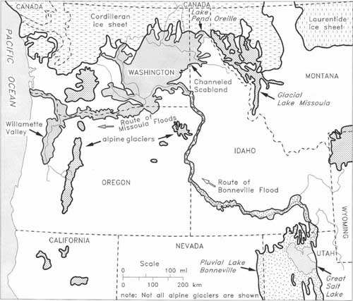
Flood Deposits. The Cordilleran ice sheet originated—several times during the Pleistocene, in fact—in the mountains of British Columbia and expanded southward into northern Washington, Idaho, and Montana. Of particular significance to the landscape of eastern Washington was a lobe of the ice sheet that flowed southward along a valley called the Purcell Trench and blocked the northwest-flowing Clark Fork River near Cabinet Gorge on the Idaho-Montana border. The ice formed a dam that created glacial Lake Missoula (Pardee, 1910), which covered 7,800 km2 of western Montana (Weis and Newman, 1989) and held 2,500 km3 of water (Waitt, 1985, p. 1280). At the ice dam, the water was approximately 600 m deep (Weis and Newman, 1989). This dam failed repeatedly (Waitt, 1980), releasing gigantic jökulhlaups that swept across northern Idaho, through the Spokane valley, southwestward across eastern Washington, through the Columbia River Gorge, and out into the Pacific Ocean (Fig. 5). In eastern Washington, the floods created the Channeled Scabland (Fig. 6), an area of intense study by J. Harlen Bretz in the 1920s. (See Baker and Nummedal, 1978, or Waitt and others, 1994, for a summary of the Channeled Scabland and a list of papers by Bretz.)
|
| Figure 5. Late Pleistocene glaciers, lakes, and floods in the northwestern United States. Dark pattern shows areas flooded by the waters released by failures of the ice dams that created glacial Lake Missoula during the Pleistocene. (Modified from Baker, 1983.) (click on image for a PDF version) |

|
| Figure 6. The Channeled Scabland of Washington. Arrows indicate direction of flood flow. (Modified from Bretz, 1959.) (click on image for a PDF version) |
In general, where water velocities were highest, the Missoula floods eroded channels and left 'scabs' or erosional remnants of basalt between the channels—hence the name Channeled Scabland for this topography in eastern Washington. Where the floods slowed down a little, such as in eddies, giant gravel bars were deposited. The Pasco gravels were transported as bed load by the floods and contain many lithologies from sources outside the Columbia River basin. Where the floods ponded, for example in the Walla Walla and Willamette Valleys, fine slackwater sediments were deposited (Bretz, 1928a); where these graded flood sediments (in which coarse sediment, pebbles and sand, is at the base of a bed and gradually becomes finer upward so that there is silt at the top of a bed) are 'repeated' vertically, they are called rhythmites. These are the Touchet Beds, named by R. F. Flint in 1938, although their origin was not then identified.
Large icebergs rode the jökulhlaups and, where they were stranded by retreating water, melted and left erratic boulders along the main route of the floods and far up tributary valleys. (See, for example, Carson, 1990, and Bartlett and Carson, 1995.)
Waitt (1980) argued that each of the approximately 40 Touchet Beds resulted from a separate catastrophic flood. These floods could only occur at times when glacial Lake Missoula existed, which Waitt (1985) estimates at between 15,300 and 12,700 years ago. Part of the reason we know the age of these strata is that ash from an eruption of Mount St. Helens, known as the set S ash (Fig. 3), fell in eastern Washington about 13,000 years ago. The ash lies on the twelfth rhythmite below the top of the Touchet Beds (Waitt, 1980).
Although the last floods from glacial Lake Missoula created the spectacular Channeled Scabland, geologic evidence suggests that jökulhlaups swept across eastern Washington long before 15,300 years ago. Other series of glacier outburst floods deposited gravels, sands, and silts at about 200,000 years ago and more than 790,000 years ago (Reidel and Fecht, 1994).
When each jökulhlaup swept through the area where Spokane is today, much of the floodwater was dumped into glacial Lake Columbia at the northern edge of the Columbia Plateau (Atwater, 1984). This lake formed when the Columbia River was blocked at the present site of Grand Coulee Dam by the Okanogan lobe of the Cordilleran ice sheet. Atwater (1984, 1986) counted flood deposits and varves (pairs of light and dark glaciolacustrine layers deposited annually) that accumulated in glacial Lake Columbia. The average interval between Missoula floods was about 30 years (Waitt and others, 1994).
Smith (1993) made a sedimentological study of Missoula flood slackwater sediments along the Columbia and Tucannon Rivers. He reasoned that a single graded flood bed was deposited at most sites during most floods, but that as many as nine graded beds were deposited during repeated surges of some floods. Smith (1993, p. 97) re-examined Waitt's (1980) sites in the Walla Walla and Yakima valleys and supports the one graded bed per flood hypothesis for those areas.
By convention, geologists place the boundary between the Pleistocene and the Holocene at about 10 ka. In the late Pleistocene and early Holocene, the climate became warmer and drier. Most of the glaciers disappeared, and the vegetation changed. (See Heusser, 1965, for a summary of vegetation and climate changes as deduced from analyses of pollen.) During the Holocene, the explosion and collapse of Mount Mazama about 6,845 years ago formed Crater Lake and showered southeastern Washington with materials blown out of the crater. Coarse pumice settled near the volcano, but finer ash drifted downwind for some distance. This erupted or pyroclastic material is collectively referred to as Mazama tephra (Bacon, 1983). About a meter of loess later blanketed the area, and dunes migrated downwind from areas along major rivers until modern dams made reservoirs that drowned the sand and silt supply. Most dunes are no longer active.
Intense agricultural activity has resulted in extreme erosion of the fine soils. This sediment is filling the reservoirs, demonstrating that pollution can be defined as a resource out of place.
ROAD LOG
This geologic road log begins and ends in the main parking lot at Whitman College, which is just east of downtown Walla Walla. The parking lot has a north entrance on Isaacs Avenue and a west entrance on Park Street. Examples of features recording the geologic history of the area are described at various stops along the way. The route of the 203-mile field trip is shown on Figure 7 (p. 8) and the back cover.

|
| Figure 7. Route of the field trip. Stop locations are indicated by the circled numbers. (click on image for a PDF version) |
In general, dimensions in this guide are given in metric units because most scientists, including geologists, communicate in this system. Two exceptions are distances on the road logs and elevations. Few U.S. cars record distance in kilometers. Elevations are given as feet above mean sea level. Most maps published in the United States still show elevations in feet. We note elevation at many locations because you may want to set your altimeter or you may want to know whether you are above or below the water level of the cataclysmic glacial floods. For example, at Wallula Gap, the maximum elevation of floodwaters was about 1,200 feet. Farther north, flood elevations were somewhat higher. This elevation information may give you a better picture of events in the Pasco Basin and Walla Walla valley.
Some Cautions Before You Set Off on This Trip
- Many of the stops are roadcuts. Be careful to park well off the pavement and beware of traffic.
- Watch out for rattlesnakes and black widow spiders. Both of these poisonous animals live in southeastern Washington. Leather boots are good protection against snakes, burrs, and sharp rocks.
FURTHER READING
For those interested in learning more about the geology of southeastern Washington and adjacent areas, the following books and articles are recommended.
General
Baker, V. R.; Greeley, Ronald; Komar, P. D.; Swanson, D. A.; Waitt, R. B., 1987, Colombia and Snake River Plains. In Graf, W. L., editor, Geomorphic systems of North America: Geological Society of America Centennial Special Volume 2, p. 403-468.
McKee, Bates, 1972, Cascadia (The geologic evolution of the Pacific Northwest): New York, McGraw Hill, 394 p.
Orr, E. L.; Orr, W. N., 1996, Geology of the Pacific Northwest: McGraw Hill, 409 p.
Volcanism and tectonism
Reidel, S. P.; Hooper P. R., editors, 1989, Volcanism and tectonism in the Colombia River flood-basalt province: Geological Society of America Special Paper 239, 386 p.
Missoula floods
Allen, J. E.; Burns, Marjorie; Sargent, S. C., 1986, Cataclysms on the Columbia—A layman's guide to the features produced by the catastrophic Bretz floods in the Pacific Northwest: Timber Press [Portland, Ore.] Scenic Trips to the Northwest's Geologic Past 2, 211 p.
Parfit, Michael, 1995, The floods that carved the West: Smithsonian, v. 26, no. 1, p. 48-59.
Weis, P. L.; Newman, W. L., 1989, The Channeled Scablands of eastern Washington—The geologic story of the Spokane Flood; 2nd ed.: Eastern Washington University Press, 24 p.
|
Conversion Factors | |
| Metric | English |
| Units of Length | |
| 1 millimeter (mm) | 0.039 inch |
| 1 centimeter (cm) | 0.39 inch |
| 1 meter (m) | 3.28 feet |
| 1 kilometer (km) | 0.621 mile |
| Units of Area | |
| 1 square meter (m2) | 10.8 square feet |
| 1 square kilometer (km2) | 0.386 square mile |
| Units of Volume | |
| 1 cubic meter (m2) | 35.3 cubic feet |
| 1 cubic kilometer (km2) | 0.240 cubic mile |
ACKNOWLEDGMENTS
The original version of this field guide was prepared for the Keck Geology Consortium Symposium, supported by the W. M. Keck Foundation and held at Whitman College in April 1993. We are indebted to Karen White for work on that manuscript. Whitman College provided vehicles for field work in connection with preparation of this guide. Ron Urban provided the plane and was the pilot for the flight to take the aerial photographs. We also acknowledge the assistance of Keith Ikerd (cartographer) and Jari Roloff (production editor/designer) for preparing final copies of illustrations and the text. Finally, we are grateful to Eric Schuster and Kitty Reed of the Washington Division of Geology and Earth Resources, Steve Reidel of Westinghouse Hanford Co., and Richard Waitt of the U.S. Geological Survey for their reviews.
| <<< Previous | <<< Contents >>> | Next >>> |
state/wa/1996-90/sec1.htm
Last Updated: 05-Aug-2011