|
GEORGE WASHINGTON MEMORIAL PARKWAY
Patowmack Canal and Locks (Great Falls Section) Historic Structures Report — Architectural Data Section |

|
APPENDIX E
ENGINEERING ANALYSIS
Engineering Analysis (Hayes, Seay, Mattern and Mattern, 1979)
An analysis of the geologic and structural conditions of the canal, locks, and gate structures is necessary in order to determine appropriate methods for preservation The following sections present a description of the existing structural conditions of the canal, with an analysis of the possible forces and stresses acting on the structures.
A. Existing Condition of Structures
The canal structures include canal walls, stone masonry locks and gate structures, vertical bedrock cuts, and the wing dam. A field investigation of the full length of the canal was conducted in order to identify geologic and structural factors and to describe the existing conditions. The following descriptions are a result of the investigation.
1. Canal Walls
The canal walls consist of earth cuts, stacked rock retaining walls and, at some locations, a combination of both types. Along much of the east side of the canal, an earth dike with rock retaining walls has been constructed, extending from Mine Run to the spillway site. The dike varies in width from about 10 to 25 feet and its apparent purpose was to isolate the canal from direct inundation by the river and to provide controlled outlet points for the canal water. The dike walls on both the canal side and the river side consist of irregular slabs of the local schist bedrock placed in a stack fashion without mortar. Backfill material behind the walls has not been determined but is possibly a mixture of rock rubble and excavated alluvial material. Only minor displacements of the retaining walls were noted and these appear to be the result of tree root pressure.
Another section of existing rock wall is located on the west bank at the guard gate site. It extends for about 50 feet along the canal and extends away from the canal for a distance of about 50 feet. Its apparent purpose was to direct water from the flood plain into the canal and also to serve as an abutment for the guard gate. This wall consists of very large rock slabs of the local schist bedrock and was also placed in a stack fashion, apparently without mortar. The wall is in very good condition except for some displacements caused by tree root pressure.
There is also a section of rock wall on the east bank extending from the grist mill site south to and including the east side of the holding basin. This section of canal is presently buried and the intent or condition of the wall cannot be determined. It may have served as a dike in similar fashion to the dike in the northern reach and/or as a roadway for carrying products from the grist mill and foundry as outlined in the report by Douglas Comer. There are some large trees located near the canal alignment which are likely exerting some pressures on the buried rock wall and causing some displacement.
In order to maintain the walls in their present condition, including those walls that are presently covered with earth fill, it will be necessary to remove all trees and shrubbery growing on or near the existing rock walls. Stumps and roots should be left in place to prevent direct disturbance of the wall materials. Trees and shrubbery located near earth or natural rock cuts should be left in place as they assist in retaining the existing soil cover.
All excavation adjacent to the existing walls should be done by hand and surcharging of the existing banks by either equipment or spoil material should be avoided.
2. Stone Masonry Locks and Gate Structures
These structures were constructed using both a quarried seneca sandstone transported from off site and local schist bedrock. The quarried stone varies from red hematitic orthoquartzite to light gray, slightly micaceous orthoquartzite. Triassic age beds to the north of the park were reportedly used as the source for the seneca sandstone.
The stones in some cases appear to have been set in a lime mortar. The mortar has almost completely deteriorated and presently provides no binding, sealing, or support for the structures. Only scattered traces of deteriorated mortar were noted.
Some form of deterioration was noted on approximately 5 percent of the quarried stones. Chemical weathering, affecting less than 1 percent of the stones, has made isolated blocks soft and friable. These weathered stones are found in direct contact with sound, unaltered blocks, which would indicate that the weathering predated the construction of the canal and most likely was a function of the position in the quarried rock mass. The remainder of the deteriorated blocks exhibit cracking, probably along pre-existing joint or fracture planes. In several cases, the cracked stones remain in place and are otherwise structurally sound.
A typical cross section of the stone masonry walls, as inferred from areas of failure where backfill materials can be seen, consists of masonry blocks laid edgewise and backfilled with cobble size schist and mortar. In some walls, alternate stones are turned with the long dimension extending into the backfill, and at least limited use of iron tie-backs was also noted. Portions of the locks were cut below natural grade. The extent of overexcavation and backfill between the wall and in-place material is not known. Elsewhere the top of the lock extended above original ground, and fill material was used to raise the grade level to the wall.
Various structural displacements noted in the locks and gates can be categorized as smooth bulges, offsets, or failures. Smooth bulges are characterized by an outward protrusion of a wall or section of wall which forms a smooth convex curve when viewed horizontally and/or vertically. Offsets consist of blocks that are displayed inward with little or not displacement of adjacent blocks. Typically, a higher block has moved inward relative to the one beneath. Failure is the complete or partial collapse of a wall or portion of a wall. In addition to these displacements, isolated blocks have been rotated or are missing from an otherwise intact wall.
It is likely that wall stability was a problem during the operational life of the canal. Large portions of the lock walls appear to have been rebuilt and can be identified by the slabs of local schist bedrock that are laid in with reused blocks of the original quarried sandstone. The displacements noted are found in both the original and rebuilt portions of the structures.
The displacements and the exertion of force against the walls can be caused by a number of factors. Lateral earth pressure can cause a soil mass to exert a horizontal force which varies depending upon the nature of the material and the degree of saturation. Tree roots can exert pressure. The deterioration of mortar can result in the removal of bond and support between blocks. Flood water and water-borne debris can cause damage. Transient forces, such as isolated acts of man or nature for which no historic record exists, are also possible sources of damage.
Continuing forces require positive structural solutions. In the case of intermittent forces, such as flood conditions, either their occurrence must be prevented, or protection against their effects must be provided. Unique events which have effected their full consequence need little further consideration if the structure is currently stable.
3. Vertical Bedrock Cuts
The very southeast end of the canal was cut through the Wissahickon schist to a maximum vertical depth of approximately 70 feet. The orientation of the canal through this cut is approximately N 50 W. Comparing this to the four prominent joint sets noted, there are three potential planes of slippage into the canal: joint set at N 45 W, 25 NE from the southwest wall; joint set at N 86 W, 80 N from the southwest wall; and joint set at N 65 W, 56 SW from the northeast wall. It appears that some bedrock has fallen from the cuts since abandonment of the canal. The configuration of the canal outlet during operation is unclear, and it is possible that considerable bedrock displacement at the river's edge may have occurred.
B. Analysis of Forces
There are a number of forces that may have contributed to the displacements of the lock walls. Lateral earth pressures, pressure from the roots of trees, and natural or man-induced accidents may have acted independently or in combination to cause the existing condition of the structures.
In order for the block facing to stand, the backfill of schist bedrock in mortar must have been designed to act as a gravity retaining wall. It is estimated that the thickness of the wall (block facing plus rubble backfill) must be approximately fourteen feet at the base in order for it to be effective as a retaining wall at the highest sections.
In several sections, the top of the wall has moved toward the center of the canal relative to the bottom of the wall. This displacement could be a result of deterioration of the mortar, both in the backfill and between courses of block in the face. This would allow earth pressure to push the upper layers slightly outward in relation to lower layers. It is possible that the forces causing this displacement could reach an equilibrium with the wall as friction between elements of the rubble fill stabilizes the wall.
It is much more likely, however, that this deterioration is progressive and will continue to worsen.
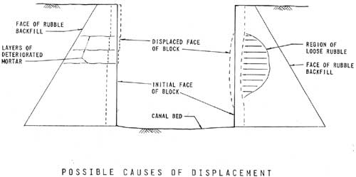
Possible Causes of Displacement
(click on image for a PDF version)
Deteriorated mortar within isolated areas in otherwise sound sections of the backfill could also be a cause of bulges or offsets. It could create pockets of loose backfill material which are no longer bonded to the retaining wall and thus exert pressures on the wall. These conditions are shown in Figure 1. Bulges could also be a result of water seeping in behind the facing layer and freezing, thereby loosening the facing from the retaining wall behind.
In addition to displacements and failures caused by deterioration of materials, instability could also be a result of a lack of support created by previous failures. The gate recess at the lower end of the river side of lock number 2 is one example. A failure in the lower part of the gate recess occurred as a result of unknown causes, and since then the lock above the original failure has been falling out because of a lack of support. The situation at the lower end of the west of lock number 1 is similar. A failure has occurred at the end of the wall and displacements have apparently occurred as a result of the lack of continuity in the wall. Ends of block which had been restrained by the section that failed are free to shift now that support is no longer available.
The causes of failure discussed so far have been based on the assumption of a well-designed retaining wall to support the lock wall faces. Actually, the original design was probably empirical, with little or no basis in theory. Earth pressure theories commonly used today are based on those proposed by C. A. Coulomb in 1776. Barely ten years elapsed before construction of the canal was begun, hardly enough time for Coulomb's theories to result in accepted design procedures. Therefore there is a possibility that, in addition to deterioration of materials, portions of the wall simply may have been poorly designed.
| <<< Previous | <<< Contents>>> | Next >>> |
patowmack_canal_hsr/appd.htm
Last Updated: 17-June-2011