|
GEORGE WASHINGTON MEMORIAL PARKWAY
Patowmack Canal and Locks (Great Falls Section) Historic Structures Report — Architectural Data Section |

|
APPENDIX H
PATOWMACK CANAL
PRESERVATION ALTERNATIVES
National Park Service
May 1985
Introduction
The Patowmack Canal was built during the years 1786 to 1802 to provide a navigable bypass to the Great Falls of the Potomac River. This canal was perhaps the most impressive element of America's pioneer effort in the comprehensive development of a river system for navigation, and it was the first corporate improvement of navigation for public use in the United States. Although it is one of the earliest canals in the United States and retains about as high a degree of integrity as the few of its era that survive, the Patowmack Canal's primary significance is that it was an engineering accomplishment with few peers in the nation and was a manifestation of the continental vision of various early American national leaders notably George Washington.
The history of the Patowmack Canal bears a direct relationship to the unifying forces and formative events which, along with self-interest, led to the U.S. Constitution. The canal project was linked with important public questions of the day—the issue of federal authority over matters pertaining to interstate commerce, the need for creation of internal improvements to link the various parts of the nation, especially the eastern seaboard with the western settlements, and the role which the central government was to play in accomplishing such internal improvements.
Attempts were made to repair certain features of the canal in the mid 1930s by the Civilian Conservation Corps. Since then work has consisted of emergency stabilization of lock structures, removal of destructive vegetative growth, and archeological investigation and salvage. The historic fabric of the canal continues to slowly deteriorate due to natural causes and to some extent by visitors. If this important historic resource is to be protected, it is essential that a preservation effort be undertaken soon.
An important part of the preservation effort will be to improve visitor understanding and appreciation of the canal and its importance to the nation. This will be done by preserving the entire length of the canal (approximately 3/4 of a mile) so visitors can appreciate the extent of the system, the difficulty of construction for that period in time, and most of all, so it can be seen and recognized as a canal system. Today, less than one third of the visitors realize that when they walk over to view the falls, they cross the remains of the historic Patowmack Canal.
Summary of Alternatives
Several alternatives are explored in this study to determine a method of preservation that will assure protection of the resources, present to the visitor a strong impression of this historic feature, and meet the criteria for cultural preservation in the National Park Service. How well each of the alternatives accomplishes these objectives is discussed in the section "Effects on the Environment" located at the end of this report.
Alternative A explores reconstructing and rewatering the entire canal system. Rewatering requires restoration of all of the canal's operating structures to a functional condition in order to maintain and regulate water flow in the canal prism. Some of the actions involved in this alternative include excavating the prism, clearing vegetation, stabilizing and restoring masonry, and reconstructing such features as the wing dam, spillways, guardgates, and locks. In this alternative, as well as the others, a pedestrian walkway is recommended along the entire length of the canal to improve visitor access and provide strong edge definition. Implementation of a rewatering plan could be accomplished in phases, the first being a partial rewatering to the mill site. The primary water source would be Mine Run. If rewatering south of the mill site is desired, water from the Potomac would be necessary and require rebuilding the wing dam.
Alternative B explores preserving the canal without the use of water, and is referred to here as a dry canal alternative. The major feature to this alternative is that the canal prism, roughly from the upstream entrance to lock 3, would be re-established and backfilled with earth to "water operating level" of the canal. From lock 3 the earth would be graded down gradually into the existing level of the gorge floor. To ensure proper drainage, a subsurface drainage system would be placed the length of the prism. In addition there would be some clearing of vegetation, selective stabilization and restoration of masonry, and a comprehensive restoration of lock 1, the interior of which would not be filled, but made accessible to the public for close inspection of 18th century lock construction. The public would also have access to the gorge via a walkway from lock 3 along the gorge floor. A pedestrian path along the canal berm would provide access to the lower locks and help delineate the canal's edge.
Alternative C is a blend of Alternatives A and B. It proposes impounding water from Mine Run between the upper canal entrance and the grist mill site. From the grist mill south the canal would be restored as a dry canal with full restoration of lock 1. Impoundment of Mine Run would require an earthen dam to be constructed at the upper end and earthenberms at the two spillways and at the grist mill site. Based on a study by the architectural and engineering firm of Hayes, Seay, Mattern, and Mattern, the amount of flow from Mine Run is sufficient to maintain water at the historic operating level between the canal entrance and the foundry site during most years.
Impounding water from Mine Run beyond the foundry site holds a greater risk that evaporation, seepage and periods of drought will prevent maintenance of adequate water levels and result in stagnant water and unwanted plant growth. Impounding water as far as the holding basin would also require the removal of a considerable number of mature trees.
CANAL FEATURES
Wing Wall
The wing wall functioned historically to divert additional water from the river into the canal, particularly during low water periods. It is original to the construction of the canal. In 1821, the records of the canal company indicate that the structure was raised and extended considerably to provide more water for operations.
The wing wall has been almost completely destroyed by flooding, although its basic configuration can be seen during low water periods. The structure is vulnerable to continued erosion, however, any attempt to reconstruct the wing wall would substantially increase the risk of damage to the remaining canal structures by diverting flood waters from the river into the canal.
Canal Prism
The canal prism is the navigable channel affording level stretches of water between the canal entrance, locks, and discharge point. Archeological investigations conducted in 1977 determined that the historic canal channel was approximately 30'—00" wide, with sloping banks giving a 12'—00" width at the bottom, and a depth of 6'—00". The canal prism was cut through bedrock in a number of locations. In areas where the channel was excavated in earth, the banks were stabilized with either riprap or dry laid stone.
The canal prism is a significant archeological feature, but for much of its length siltation and/or erosion have obliterated surface traces of its course.
First Spillway and Upper Guard Gate
The first spillway and upper guard gate serve to divert flood waters from the canal back into the river. No reference to these features is found in the operating records of the canal which would place their construction within the historic period. While it is possible that the existing structures represent the location of historic features, the workmanship suggests major reconstruction by the Civilian Conservation Corps.
Lower Spillway
The lower spillway serves as a leveling device, discharging excess water into the river. There is no evidence that it is an historic feature and the workmanship is nonhistoric.
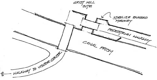
Grist Mill and Foundry
Waste Weirs
The waste weirs at the grist mill and foundry sites functioned historically to provide a stream of water to power the mill wheels. The location of these features is historic, but the workmanship is not historic.
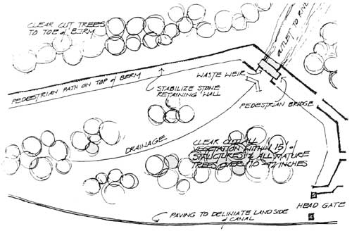
Holding Basin
The holding basin functioned as a reservoir to impound sufficient water to operate the locks. Roughly triangular in form, it was 1,175 feet in length, 210 feet at it widest point, and a maximum of 13 feet deep. The eastern bank consisted of a berm and stone retaining wall. The top of the berm is believed to have incorporated a 12 foot wide pathway which permitted products from the grist mill and foundry to be transported to the holding basin where they were loaded onto boats. At the downstream end of the holding basin are the remains of two masonry control structures. The larger of the two served as a waste weir to control the elevation of water in the holding basin, or permit it to be drained entirely. The second structure may have provided an outlet for water to be channeled into a small holding basin downstream at lock 3.
At present the configuration of the holding basin is largely obscured by vegetation and erosion. The masonry features have suffered damage from erosion, displacement of stones, and intrusive root systems. The waste weirs have been largely reconstructed after the historic period. Evidence of gates and operating features has been destroyed.
Guard Gate
The guard gate structure, located above the locks at the lower end of the holding basin, is an original feature of the historic canal. Patowmack Company documents record completion of the masonry walls and installation of the gates in the summer of 1796. The guard gate controlled the flow of water to the locks below. In the event of flooding, the guard gate was closed and the excess water discharged through the holding basin waste weir, minimizing damage to the locks. Also by closing the gates, the locks below could be drained for repairs. The gate structure is constructed of quarried Seneca sandstone and local schist bedrock. Some displacement of masonry is evident, but there is no evidence of major structural failure. The fact that the structure is partially filled with earth has contributed to its preservation.
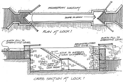
Lock 1
Lock 1 is original to the construction of the canal, and the best preserved of the lock structures. Lock 1 is 100'—0" in length, and at 14'—0", the widest of the locks. It was designed for a lift of 10'—0" and a capacity of 18,200 cubic feet. Canal company records document orders for quarried Seneca sandstone to build the lock, construct the gates, and complete the structure by 1796.
Although some displacement of stones and isolated deterioration of blocks is evident, the structure is relatively stable.
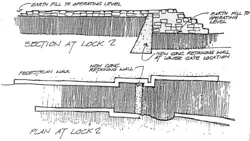
Lock 2
Lock 2 is also original to the construction of the canal and retains a high degree of historic integrity. As constructed, it had a lift of 16'—0" and a capacity of 22,800 cubic feet. After the completion of lock 1, the Patowmack Company encountered financial difficulties and construction delays, therefore work on the lower locks was mostly completed after the spring of 1800. In the interim, the designed width of the locks was reduced to 12'—0", although the length remained constant at 100'—0".
The existing condition of lock 2 is poor, as evidenced by three major structural failures. Large bulge failures exist on both walls and the east wall leans inward due to back pressure.
Locks 3, 4, and 5
Locks 3, 4, and 5 were joined. forming a riser of three steps having a combined lift of 50 feet. Their capacities were respectively 20,400, 25,200, and 25,200 cubic feet. The masonry structures of lock 3 are partially buried, with about 6 to 8 ft. of the west wall remaining exposed. The exposed masonry exhibits structural failures and evidence of several periods of reconstruction. The historic fabric of the structure has been seriously compromised.
Locks 4 and 5 were cut through bedrock. Except for an isolated masonry structure on the southwest wall, and remnants of wrought iron anchors, nothing remains of the gates and operating features. There is insufficient evidence for reconstruction.
ALTERNATIVE A: REWATER CANAL
In order to rewater the entire canal, it is necessary to restore all of its operating structures to a functional condition for the following reasons:
To maintain water in the cut
To insure sufficient water and/or relieve excess water
To regulate the flow of water

(click on image for a PDF version)
Summary of Actions
• Restore wing dam
• Entrance to canal
Remove silt build up
Clear and thin vegetation
Excavate canal prism
• Restore first spillway
Demolition
Restoration
• Upper guard gate
Masonry repair and restoration
Reconstruct gates
• Canal to lower spillway
Excavation
Clear and thin vegetation
Repair canal walls
• Lower spillway
Restore to operating level of canal
• Excavate canal from lower spillway to grist mill
• Grist mill site
Restoration of mill outlet to retain water at operating level of canal
• Canal from mill site to holding basin
Excavation
Stabilization of canal walls
Removal of existing walkway
• Holding basin
Clear cut vegetation within berm
Selective cutting of mature trees
Excavation
Restoration of berm
• Reconstruct waste weir
• Reconstruct lower basin feeder gate
Lower guard gate
Restoration and stabilization of masonry
Reconstruct gates
• Lock 1
Excavation
Masonry stabilization and restoration
Reconstruct floors, sills, gates and hardware
• Lock 2
Excavation
Masonry stabilization and restoration
Reconstruct floors, sills, gates and hardware
• Lower holding basin
Excavation
Clear cut vegetation
Reconstruction of walls
• Lock 3
Excavation
Restore west (landside) wall
Reconstruct east wall
Reconstruct timber framing, gates and hardware
• Lock 4 and 5
Clear debris
Reconstruct timber framing
Reconstruct masonry
Reconstruct gates
Reconstruct operating hardware
• Selective clearing of vegetation at locks
• Reconstruct visitor walkway from mill site to locks 3, 4, and 5
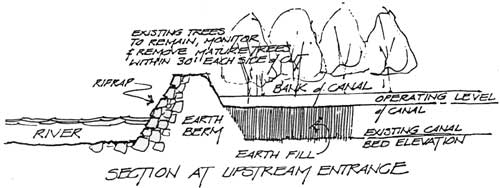
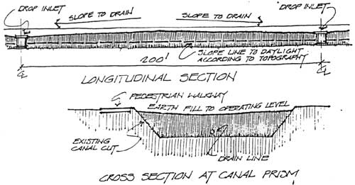
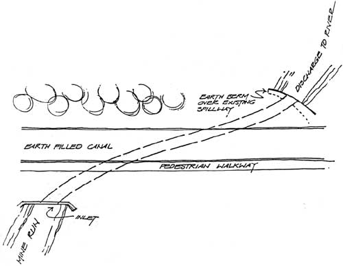
ALTERNATIVE B: DRY CANAL
Canal Prism
• Construct earthberm at upstream end of river
• Backfill canal prism with earth to operating level of canal
(click on image for a PDF version)
• Install subsurface drainage system in canal prism
• Construct pedestrian walkway
(click on image for a PDF version)
• Construct diversion structure and culvert to conduct Mine Run underground to its natural discharge point approximately 200' downstream.
(click on image for a PDF version)
• Stabilize and selectively restore associated masonry structures
(click on image for a PDF version)
(click on image for a PDF version)
Holding Basin
• Provide earth fill to operating level with drainage to waste weir
• Stabilize and selectively restore waste weir and associated masonry features
• Stabilize stone retaining wall
• Construct pedestrian path on river side and bridge at waste weir
• Clear and thin vegetation, reseed
• Pave to delineate land side of canal
Head Gate
• Selective stabilization and restoration of masonry
• Earth fill to operating level of canal
• Clear and thin vegetation, reseed
Lock 1
• Excavate lock chamber to historic elevation
• Selective restoration and stabilization of masonry
• Reconstruct and install two pairs of lock gates
• Backfill at lock ends to historic operating level
• Provide subsurface drainage
• Construct stair and walkway
• Clear and thin vegetation, reseed
(click on image for a PDF version)
Lock 2
• Selective restoration and stabilization of masonry
• Install subsurface drainage
• Construct retaining wall
• Earth fill to operating level of canal
• Clear and thin vegetation, reseed
imageLocks 3, 4, and 5
• Stabilize exposed masonry
• Provide earth fill to operating level and grade to gorge
• Clear and thin vegetation, reseed
• Clear debris in gorge
• Construct pedestrian walkway in gorge with barrier at river
Summary of Actions
• Canal Prism
Construct earthberm at upstream entrance
Backfill canal prism to operating level
Install subsurface drainage
Construct pedestrian walkway
Clear and thin vegetation, reseed
Construct culvert at Mine Run
Stabilize and restore masonry structures
• Holding Basin
Stabilize stone retaining wall
Selective restoration of masonry features
Clear and thin vegetation, reseed
Provide earth fill to operating level
Construct pedestrian walkway and bridge
Paving to delineate land side of canal
• Head Gate
Selective restoration and stabilization of
masonry
Earth fill to operating level
Clear and thin vegetation, reseed
• Lock 1
Selective restoration and stabilization of
masonry
Excavate lock to historic elevation
Reconstruct two pairs of lock gates
Provide subsurface drainage
Backfill at lock ends
Construct stair and walkway
Clear and thin vegetation, reseed
• Lock 2
Selective stabilization and restoration of
masonry
Install subsurface drainage
Construct retaining wall
Earth fill to operating level
Clear, thin, and reseed vegetation
• Locks 3, 4 and 5
Stabilize masonry
Clear, thin, and reseed vegetation
Earth fill to operating level
Construct pedestrian walkway in gorge with barrier at
river end
Clear debris in gorge
ALTERNATIVE C: IMPOUNDMENT
• Partial rewatering of the canal, using water from Mine Run to impound water from the upstream entrance to the grist mill site
(click on image for a PDF version)
Summary of Actions: Impoundment
• Canal Entrance
Clear and thin vegetation
Earth berm dam with riprap on river side
and overflow structure for excess water from Mine Run
• First Spillway
New riprapped earthberm over existing stone remains
• Canal to Lower Spillway
Clear and thin vegetation
Selective repairs to stone walls
• Regrade canal bed
• Lower spillway
• Canal from lower spillway to grist mill
Excavation and dewatering operations
Cut back and riprap at existing drainage entering canal
• Grist mill site
Construction of outlet point, waste weir and spillway
Riprapped earthberm at limit of impounded area
Summary of Actions: Dry Section
• From lower spillway to holding basin construct
pedestrian walkway
Clear and thin vegetation, reseed (past grist mill site)
Stabilize and restore masonry structures
• Holding Basin
Stabilize stone retaining wall
Selective restoration of masonry features
Clear and thin vegetation, reseed
Provide earth fill to operating level
Construct pedestrian walkway and bridge
Paving to delineate land side of canal
• Head Gate
Selective restoration and stabilization of masonry
&nbap;&nbap;Earth fill to operating level
Clear and thin vegetation, reseed
• Lock 1
Selective restoration and stabilization of masonry
Excavate lock to historic elevation
Reconstruct two pairs of lock gates
Provide subsurface drainage
Backfill at lock ends
Construct stair and walkway
Clear and thin vegetation, reseed
• Lock 2
Selective stabilization and restoration of
masonry
Install subsurface drainage
Construct retaining wall
Earth fill to operating level
Clear, thin, and reseed vegetation
• Locks 3, 4 and 5
Stabilize masonry
Clear, thin, and reseed vegetation
Earth fill to operating level
Construct pedestrian walkway in gorge with barrier at
river end
Clear debris in gorge
COST SUMMARY
The following figures reflect the estimated initial cost to implement each of the alternatives and the follow-up costs to adequately maintain and repair the structure.
| Rewatered Canal |
Dry Canal |
Impoundment | |
| Initial Cost | $5,630,000.00 | $2,320,500.00 | $2,037,000.00 |
| Yearly Maintenance | 42,000.00 | 32,000.00 | 30,000.00 |
| Cyclic Maintenance (for 20 years) | $497,333.00 | $68,000.00 | $36,000.00 |
EFFECTS ON THE ENVIRONMENT
Cultural Resources
The enabling legislation for George Washington Memorial Parkway states as part of the purpose of the Great Falls unit, "... the preservation of the historic Patowmack Canal." The Patowmack Canal Historic District is listed on the National Register of Historic Places and includes the canal and its related structures and ruins, and the ruins of the grist mill, foundry, and town of Matildaville. The State Historic Preservation Officer and the Advisory Council on Historic Preservation will be asked to comment on any proposed action in accordance with Section 106 of the National Historic Preservation Act.
There are substantial gaps in information concerning the historic characteristics of various canal features. There are also many unanswered questions about past reconstruction work, including undocumented repairs in the 20th century. To resolve these issues prior to the proposal of specific treatments for the canal features, the National Park Service will need to prepare a Historic Structures Report, architectural data section.
All three alternatives would include excavation of the canal prism and other ground disturbing activities. An archeologist will monitor construction activities to examine cultural items or structural features discovered and to prevent damage to the canal banks.
Alternative A—Rewatered Canal
Application of the Advisory Council's criteria of effect and adverse effect (36 CFR 800.3) to the rewater alternative indicates that the functional restoration to a rewatered canal would appear to have an adverse effect on the qualities which make the resource eligible for listing on the National Register.
The lower guard gate, lock 1, and lock 2 are the only canal structures which show evidence linking them to the historic functioning canal. To make the guard gate and lock functional, their masonry walls would be disassembled and rebuilt with concrete backing support walls. The value of these structures is that they are the only remaining original works of the George Washington period. The actions of disassembling and reassembling in order to rewater the canal would appear to sacrifice the integrity and value of these original works.
The other less complete canal structure would require that missing elements be reconstructed for them to be functionally restored. The lack of information regarding these elements means that reconstruction would not be historically accurate. This is particularly true for locks 4 and 5. These major canal structures are almost completely missing from the cut through the bedrock. These alterations to the historic resource would appear to constitute an adverse effect.
In 1983, the Interior Secretary's Advisory Board conferred the National Historic Landmark designation on the Patowmack Canal. As part of their recommendation, they urged the National Park Service to refrain from reconstruction of the canal, if proposed, but to improve both the care and interpretation of the canal to a standard meeting the requirements of the 1980 Preservation Amendments (Sec. 110f) regarding National Historic Landmarks.
In addition, the reconstruction activities would conflict with the National Park Service Management Policies (1978, Chapter V, pages 15-17) and Cultural Resources Management Guidelines (1981, Chapter 2 — Standards for Internal Service Activities). These state that ". . .the Service does not endorse, support, or encourage the reconstruction of historic structures," that..... "reconstructions shall be undertaken only if such work is absolutely essential for public understanding" and "data must be sufficient to permit accurate reproduction...with a minimum of conjecture." Since reconstruction would require considerable conjecture and public understanding can be achieved by other preservation methods (see the section on Interpretation), the undertaking of reconstruction would appear to be in conflict with NPS policy. All reconstruction projects require formal approval from the director.
Rewatering would also subject the canal structure to the destructive forces of water. During floods the restored wing dam would funnel high velocity flood waters directly into the canal, with potential damage to the canal masonry structures. The freeze/thaw action, flow and pressure of water would contribute to deterioration of the masonry walls and the wet/dry cycle would affect the wooden gates. NPS historic preservation professionals experienced in historic canal work have examined the historic repair record and calculated that no canal structures can withstand more than a 5-year flood without sustaining damage. A continual repair cycle would be necessary to maintain deteriorating masonry and wooden gates, as well as remove silt. Refer to the cost summary on page 18. The degree of general deterioration that would affect a rewatered canal and the increased potential for flood damage would appear to be an adverse effect on the resource and be in conflict with the preservation mandate of the enabling legislation.
The Cultural Resources considerations (Section 7(A)) of the NPS Floodplain Management and Wetland Protection Guidelines are also applicable. These state that "cultural resources located in floodplains will be managed to assure their in-place preservation. . . .and. . .designed so as not to adversely affect the historic integrity of the structure." The rewater alternative would appear not to meet these requirements.
In terms of the visual nature of the historic canal and its setting, the rewater alternative would provide the most appropriate visual characteristics and the ideal basis for historic interpretation.
Alternative B—Dry Canal
The dry canal alternative would provide effective preservation of the canal structures. Removal of all water from the canal would eliminate the deleterious effects associated with freeze/thaw, flow, and water pressure. The construction of a berm at the upstream end of the canal would block flood waters from entering the canal until they topped the berm. The drainage system would remove runoff that drained into the canal prism.
The historic integrity of the guard gate and locks 1 and 2 would be maintained, since, without water in the canal, disassembling would not be necessary for the selective restoration and stabilization. Lock 2 would also be selectively restored and stabilized and then earth filled to the canal operating level. Placement of earth fill there and in the other locks and canal areas with masonry walls would help support and effectively preserve the walls. All masonry structures would receive stabilization or restoration work and the canal prism would be excavated and delineated.
Filling the canal with earth to the operating level would introduce a non-historic visual element to the resources. Earth fill is, however, an accepted preservation practice and in this case would be done to represent the original water level. Other non-historic elements that would be added include the berm at the upstream end of the canal, the culvert to conduct Mine Run under the canal, minor drainage structures, the stairs in lock 1, the concrete retaining wall in the lower gate location of lock 2 and the barrier at the downstream end of the canal gorge. The visual intrusion of these structures constitutes minor adverse effects, but are necessary to the overall preservation plan.
Two pairs of lock gates would be reconstructed for lock 1. Archeological investigation of the gates in 1980 yielded information that would minimize conjecture during reconstruction.
The dry canal alternative appears to have no overall adverse effect on the canal's National Register eligibility qualities.
Alternative C—Impoundment
The impoundment alternative would provide the same preservation benefits as the dry canal alternative for the area downstream from the grist mill. Treatment of the locks, guard gate, and holding basin would be exactly as for the completely dry canal, including the introduction of the non-historic elements.
The partial rewatering of the upstream portion of the canal would leave the masonry there exposed to the effects of water, but the structures in this area are not as historically significant and in need of protection as the guard gate and locks 1 and 2. It is also possible that the walls and structures in the upstream canal area have had major reconstruction by the Civilian Conservation Corps. Earth berms would be introduced at the two spillway sites to keep canal water from flowing out into the river. The spillways would not be restored in this alternative, since it is not the objective of this alternative to fully restore the functioning canal structures. All the treatments of structures in the impoundment alternative would be reversible so that full restoration would be possible at a later date, if desired.
An earth berm would cross the mouth of the canal, prohibiting the inflow of Potomac River water. The impoundment would use water from Mine Run instead. This would provide flood protection for the impoundment. A riprapped earth berm would be constructed at the downstream limit of the impoundment near the grist mill site. The various berms would constitute introduced non-historic elements. Some reconstruction of the grist mill waste weir would be implemented, and this would be somewhat conjectural.
The impoundment alternative appears to have no overall adverse effect on the canal's National Register eligibility qualities.
Natural Resources
The canal is located within the 100-year floodplain and all three alternatives will result in similar effects on the floodplain values and the park's natural resources. Construction activities will cause minor short-term increases in erosion, but these will be mitigated with sediment traps and immediate reseeding. Trees and vegetation will be removed in all alternatives; the degree of vegetation removal and loss of wildlife habitat in each alternative is discussed below:
Alternative A—Rewatered Canal
The restoration of the wing dam in the rewater alternative will have minor adverse effects on the Potomac River. Heavy construction equipment will disturb the river bottom and marsh vegetation existing along the shore near the mouth of the canal. These effects should be short-term. A hydrological study will be necessary to determine what the configuration of the dam and river bottom will have to be in order for adequate water to be channeled into the canal. The presence immediately upriver of the U.S. Army Corps of Engineers dam, which channels river water into the drinking water intake on the opposite shore, may prevent sufficient water from entering the canal. The Corps dam did not exist during the historic canal operating period. The restoration of the wing dam will require permits and consultations with the states of Maryland and Virginia, U.S. Fish and Wildlife Service, U. S. Army Corps of Engineers and the Environmental Protection Agency.
The rewater alternative will require the removal of all the vegetation in the holding basin. Presently, the basin is an attractive glade of trees and wild flowers. This would result in the destruction of animal habitat and reduction of food supply and shelter for wildlife population. The existing stream would flow into the basin eliminating the present lush riparian wetland habitat. This loss of bottomland habitat would be somewhat mitigated by the creation of aquatic habitat in the rewatered holding basin and canal. Rewatering should also minimize stagnation of water, which is currently an occasional problem.
Alternatives B and C—Dry Canal and Impoundment
The impoundment alternative will also create some aquatic habitat and minimize stagnation in the rewatered canal section from the mouth to the grist mill. Stagnation would be eliminated in the dry canal sections of the impoundment and dry canal alternatives.
Selective removal of vegetation in the dry canal of both of the impoundment and dry canal alternatives would also result in the loss of wildlife habitat, but to a lesser extent than the rewater alternative. In the rewater alternative, all vegetation must be removed, but in the other two alternatives, the habitat loss in the holding basin could be minimized by decreasing the vegetation removal. The preservation plan calls for earth fill to the operating level, thinning out of most of the trees and reseeding to create a parkland area of trees and grass.
More natural vegetation could be retained with less fill or grading if the holding basin is kept as a glade-like environment. Selective removal of some trees is necessary to achieve the interpretive objective of visitors being able to see the delineation of the basin from the opposite side. This objective is not in consistent with a glade which would retain the attractive wild flowers, continue to provide wildlife habitat, and require less maintenance. In addition, the trees and vegetation in the holding basin provide protection from floods. The roots help secure the earthen structure of the holding basin, and the trees and other vegetation help protect the historic masonry structures down the canal from flood waters and water borne debris.
Visitor Use
There are several ways to describe visitor use in a park setting. In most cases, a collection of variables provides the most accurate description. The following six variables were used to describe visitor use at Great Falls Park during the summer of 1983:
• Distribution of Visitors (how many people use different areas of the park)
• Group size (number or percentage of groups of different sizes using the park)
• Gender (male to female ratio of visitors)
• Age Group (how many visitors are children, teenagers, adults, or senior citizens)
• Ethnic Group (number of visitors that are white, black, oriental or other ethnic group)
• Activities (what people do while in the park)
When the three preservation alternatives presented in this document are assessed for their probable effects on these six variables, only the Distribution of Visitors and Activities variables will be noticeably affected by the three alternatives. The dry canal alternative will have the least affect on visitor use in the park. Improvement to the canal and pathways along its length will attract more people to walk the length of the canal, particularly in the direction of lock 5 (downstream), but no other noticeable changes are expected.
The two other alternatives, with the addition of a new water feature in each, will have more apparent effects on both the Distribution of Visitors and kinds of Activities people participate in. The impoundment alternative will most significantly affect access to the area around Overlook One and north to the beginning of the canal. The impounded canal and the spillway back to the Potomac River will effectively create an island of this area with the only dry access at the proposed earthen dam at the north end. The effect of this condition would be to seriously limit access to this dangerous section of shoreline above the falls. It would also make Overlook One inaccessible unless a bridge is provided. Since Overlook One is nearest the waterfalls, the effects of sound, temperature changes, and water spray are most dramatic there. Elimination of this experience would be a loss to be measured against the benefits of reducing the chances of accidental drowning.
The rewatered canal alternative will also affect distribution of visitors by the location of bridges across it. By limiting crossings to locations south of the grist mill site, fewer visitors would be expected to backtrack to the more dangerous area north of the falls.
The provision of a quiet water feature (rewatered canal and impoundment alternatives) would add a new element to the park that would be an attraction for strolling along, sitting or picnicking beside, wading, or taking photos of. As such, the effect would be to enrich the experience of a visit to the park, and possibly result in some increase in park visitation.
Interpretation
The story of the Patowmack Canal has received little emphasis in the park's interpretive program in the past. This situation, combined with the canal's poor physical condition, has limited the public's awareness and understanding of the structure. By implementing any one of the preservation alternatives, public awareness of the canal will improve significantly because preservation will give strong definition to the entire canal and make it a major visual element within the park landscape.
Although public awareness of the canal is an important first step, achieving public understanding of the canal's significance requires that the park implement an effective interpretive program about the Patowmack Canal. Currently, the park's interpretive information relating to the canal does not effectively convey that story. The existing waysides are poorly located and designed and provide inadequate and sometimes incorrect information. With any of the preservation alternatives, a new wayside system will be necessary. The locations of the waysides and the information they contain will probably not vary much from one alternative to another. The information in the waysides will focus primarily on the canal features. The more abstract information about the people and events associated with the canal's creation and operation should be interpreted primarily through media such as park literature, film, and exhibits. New temporary exhibits relating to the canal are planned for the visitor center and certain existing exhibits will be improved. Prior to and during actual preservation work, interpretive panels will be necessary both inside the visitor center and along the canal to help visitors understand what is happening to the park.
Under each alternative there are certain positive and negative effects on the eventual interpretation of the resource. The following sections highlight those effects by alternative.
Alternative A—Rewatered Canal
A rewatered canal with restored and operating lock structures would enable visitors to quickly recognize the feature as a canal and get a feeling for its original appearance and function. Also, as a water feature, the canal would attract attention and curiosity and thus more visitors would be likely to stroll its banks and read about the canal from nearby interpretive waysides.
The drawbacks to a completely rewatered system are three-fold. First because much of the information on the original canal features is missing, many of the new features would be reconstructed based on conjecture. The result is recreation of an inaccurate historic scene. That poses problems to interpreters who would have to explain these inaccuracies, thus taking time and emphasis away from the canal story and possibly confusing visitors.
Also, one of the most significant aspects of the canal is the engineering methods used in its construction. Rewatering will hide many of the construction details of the locks and prevent visitors from more personal inspection of such details. This is particularly true for lock 1 and the gorge area.
Finally, a rewatering effort places considerable emphasis on the canal as a successful operation, where in truth it was an economic failure. Its 28 years of operation were plagued with financial problems, many of which were tied directly to flooding, freezing, or low water conditions on the Potomac that regularly left the canal either severely damaged or without enough water to properly operate the locks. As a result, the canal was active for only about 2 months every year. Its erratic and limited operating schedule discouraged traffic, thus limiting income from tolls. Also, the depressed condition of the company's finances and inadequacy of its system frightened away potential investors. The many problems of the Patowmack Canal system eventually led to the chartering of the Chesapeake and Ohio Canal in the 1820's. This was a total canal system where the water supply could be controlled throughout. In 1828 the charter and papers of the Patowmack Canal Company were transferred to the C&O Canal and in 1830 the canal stopped operating altogether.
Alternative B—Dry Canal
Interpretation of a dry canal would be very feasible although somewhat more difficult than a rewatered canal. Having a rewatered canal and operating features allows for quick recognition of the structure as a canal. Without these aspects, the visitor must depend more on interpretive media and his own imagination to visualize what the canal may have looked like. This alternative would provide strong definition of the canal prism and edges, restore lock 1, and give visitors access into the gorge. These actions, plus providing an effective interpretive program of waysides, etc., would go a long way in helping the public visualize the historic setting.
Also, within the holding basin area are many trees, which if removed, would give much greater definition to that space and enable visitors to better visualize its historic appearance. Even if complete tree removal does not occur, there are several steps which could improve the site's historic appearance. Currently, there is one major and several minor paths which cut across the holding basin, breaking up its continuity. These would be rerouted to follow the edges of the holding basin. The paths should be well defined and visible from the opposite path so that visitors can get a sense of its breadth. Trees along the edges would be removed and the interior gladed out in order to keep views across the basin open.
There also are certain interpretive advantages to keeping the canal dry. A dry canal places appropriate emphasis on the fact that it was inoperable most months of the year because of its dependence on the unpredictable flows of the Potomac River. Also, there is less chance visitors will confuse the Patowmack Canal with the rewatered C&O Canal if the Patowmack is left dry. This would also help reinforce the fact that the Patowmack Canal's economic failure led to the chartering of the C&O Canal, which was operable more consistently and for many more years because it was a contained slackwater canal not dependent on the fluctuating levels of the Potomac River.
Also, by keeping the canal dry and providing access into lock 1 and the gorge, visitors can get a feeling for the dramatic scale and difficulty of the project and they can observe closely such features as the hand-drilled holes in which explosives were placed, the mason marks inscribed on the cliff walls and the iron stakes and rings which are the only remnants left of the lower lock structures.
Alternative C—Impoundment
A primary benefit of impounding water in the upper canal would be aesthetic, since the attractiveness of the water would draw activity along its edge. A side benefit may be that more individuals, drawn to that portion of the canal, would become interested in exploring and learning about the rest of the canal.
The main drawback would be that an impoundment such as this never existed historically, thus introducing a major inaccuracy into the scene. It would have no interpretive advantages in explaining the workings of a canal, since none of the canal features along that portion would be operable. Also, the most effective interpretive aspect of a rewatered canal or section of canal would be a lock. Since no locks are located here, these could not be interpreted.
| <<< Previous | <<< Contents>>> | Next >>> |
patowmack_canal_hsr/apph.htm
Last Updated: 17-June-2011