|
Hagerman Fossil Beds National Monument Idaho |
|
 NPS photo | |
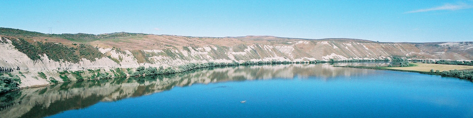
Hagerman Fossil Beds National Monument, in Idaho, is most famous for the Hagerman Horse, which is also the state fossil. The monument is significant for its variety, quantity, and quality of animal and plant fossils.
What the Scientists Found Here
No other fossil beds preserve such varied land and aquatic species from the time period called the Pliocene Epoch. Over 200 species of plants and animals have been found at hundreds of sites in this park. Eight species are found only here, and 43 were found here first. The Hagerman horse, Equus simplicidens, typifies the fossil quality. Complete and partial skeletons of this zebra-like ancestor of today's horse have come from these fossil beds.
Paleontologists from the Smithsonian Institution in Washington, DC, made the first scientific excavations here in 1929. Local rancher Elmer Cook had shown the fossil beds to a government geologist, Dr. Harold Stearns. During the 1930s, the Smithsonian scientists excavated 120 horse skulls and 20 complete skeletons from an area now called the Horse Quarry. The Smithsonian exchanged some Hagerman horse skeletons with other museums, resulting in their display around the world. Other museums, universities, and the National Park Service have now done work here. Over 200 scientific papers now focus on the Hagerman fossil species.
Hagerman Fossil Beds has produced 20 complete skeletons of Equus simplicidens, the Hagerman Horse.
Clues in the Landscape
Bluffs that contain Hagerman Fossil Beds rise 600 feet above the Snake River. They reveal the environment at the end of the Pliocene Epoch. Grassy plains with ponds and forest stands then received over twice today's 7-10 inches of annual precipitation. Saber-toothed cats, mastodons, camels, ground sloths, hyena-like dogs, beavers, muskrats, otters, antelope, deer, fish, frogs, snakes, and waterfowl lived then.
Sediment layers from river to bluff tops span 550,000 years: 3.7 million years old at river level to 3.15 million years atop the bluff. The layers were deposited when rivers flowing into ancient Lake Idaho flooded the area. The Bonneville Flood 15,000 years ago carved the high bluffs, exposing the layers and fossils. It also deposited fields of melon gravel—lava boulders the size of watermelons and larger from today's river level to gravel bars 225 feet higher. Sediments include river sands, shale deposited in ponds, clay from floods, and volcanic deposits like ash and basalt. Radioactive elements in volcanic ashes are used to determine a fossil's age.
The Hagerman Horse probably is more closely related to Grevy's zebra than the horse. Scientists conclude this because its skull looks very much like a zebra's. Scientists also speculate the Hagerman Horse may have had stripes.
Adapt, Migrate, or Become Extinct
As significant environmental change happens, most plants and animals will have three options: adapt, migrate, or become extinct. The ancient ecosystem of Hagerman's fossil plants and animals shows each response as the area changed from a wetter grassland savanna to today's drier high-desert conditions.
Hagerman Fossil Beds is one of the few sites that preserve enough variety and quantity of fossil evidence to study past climates and ancient ecosystems. Fossil studies also add to research on biodiversity, wetlands ecology, and evolutionary patterns.
Adapted
Beavers that lived here in Pliocene times adapted to change, and their descendants live here today. Muskrat and many birds also adapted.Migrated
Horses migrated to Eurasia when habitat conditions changed here. Camels also migrated to Eurasia. Llamas migrated to South America.Became Extinct
Mastodons were not able to adapt or migrate, so they died out. Ground sloths, hyena-like dogs, and saber-toothed cats also became extinct.
Epochs of the CENOZOIC
Holocene |
11,700 Before Present (BP) to present
Horses reintroduced into North America by Spanish 1500s Extinction of North American megafauna, including horses 13-10,000 BP |
Pleistocene |
2.6 mya-11,700 BP
Bonneville Flood 15,000 BP Damming of Snake River by McKinney Butte Basalt 50,000 BP Immigration of bison into North America from Eurasia 400,000 BP Lake Idaho drains 1.7 mya Immigration of mammoth into North America from Eurasia 1.8-1.6 mya |
Pliocene |
5.3-2.6 mya
First appearance of modern horse (Equus) at Hagerman 3.2 mya Volcanic eruption at Yellowstone deposits Peters Gulch Ash at Hagerman 3.9 mya Ancestral Snake River begins depositing sediments at Hagerman 4.3 mya First appearance of modern beaver (Castor) 4.8 mya |
Miocene |
23-5.3 mya
Banbury Basalt forms floor of what is now the Hagerman Valley 8-11 mya Bruneau-Jarbidge eruption southwest of Hagerman deposits ash as far east as Nebraska 11 mya Gomphotheres (early elephants) immigrate into North America from Eurasia 14.5 mya |
Oligocene |
38 mya
Volcanism in the Challis area begins 51 mya |
Eocene |
55 mya
First horse (Hyracotherium) 57.5 mya |
Paleocene |
65 mya
Extinction of dinosaurs 65 mya Gap in the record |
  (click for larger maps) |
Indians, Emigrants, and Farmers
American Indians now known as the Shoshone-Bannocks and the Shoshone-Paiutes have lived in the Hagerman Valley for 12,000 years. They caught and dried salmon, steelhead trout, whitefish, and other fish—including sturgeon weighing over 1,500 pounds. They dug camas lily and other roots and harvested seeds, fruits, and other plants. They hunted small animals and deer, elk, and mountain sheep.
Well-preserved segments of the Oregon Trail exist in the southern part of the monument. Intense summer heat, dust, wind, and lack of water made crossing the Snake River Plain an ordeal. The Hagerman Valley was one of the few places where emigrants could reach the Snake River for water and to trade for fish with American Indians. Another 700 miles of arduous travel lay between here and their destination.
In 1862, the Idaho gold rush increased traffic on the Oregon Trail. Trains of freight wagons hauling up to five tons each brought supplies to Army camps, mines, and developing towns. A few ranchers settled here later. Farming began in the valley in 1879, with John Bell growing alfalfa. In 1882, the Oregon Short Line railroad arrived north of the valley, and farming settlement increased. Today's farmers grow corn and potatoes as the major crops.
Bounded on the east by basalt cliffs formed from past lava flows, the valley boasts many springs. Their water exits the ground at a consistent temperature that is ideal for raising trout. Because the springs also keep the wetlands from freezing in winter, many migrating waterfowl spend the winter here.
Visiting the National Monument
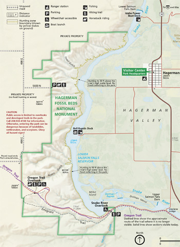
The visitor center is across from the high school on US 30 (221 N. State Street). It offers information, exhibits, displays, and a bookstore. Open 9 to 5 seasonally; call ahead or check the park website for the schedule. Ranger-led programs are listed on the website.
To reach overlooks, drive south on US 30 and cross the Snake River on the Gridley Island Bridge. Turn right on Bell Rapids Road and drive 2.8 miles. The Snake River Overlook is on the right, 0.10 mile after you enter the monument. The boardwalk has exhibits and provides a view of the fossil beds and Snake River. Cross the road to an exhibit about the Oregon Trail; follow the path to see the famous trail.
Continue up the road for three miles to reach the Oregon Trail Overlook. Walk the half-mile interpretive trail to enjoy commanding views. You can also start the Emigrant Trail here. This three-mile trail parallels the Oregon Trail.
Regulations and Safety
Check at the
visitor center before driving in the monument to find out which areas
are open to the public and if safety restrictions are in place.
For firearms regulations, check the park website.
All natural and historic features are protected by federal law. Do not take, disturb, or damage any fossil. If you find a fossil, leave it in place and report it to a ranger. Many fossils are fragile and must be protected by trained experts before they can be moved safely.
Emergencies call 911
Accessibility
We strive to make our facilities, services, and programs accessible to
all. Call or check our website.
Source: NPS Brochure (2014)
|
Establishment Hagerman Fossil Beds National Monument — November 18, 1988 |
For More Information Please Visit The  OFFICIAL NPS WEBSITE |
Documents
A Study of the Fossil Horse Remains from the Upper Pliocene of Idaho (C. Lewis Gazin, extract from Proceedings of the United States National Museum, Vol. 83 No. 2985, 1936)
A Traditional Use Study of the Hagerman Fossil Beds National Monument and Other Areas in Southern Idaho (L. Daniel Myers, September 1998)
An Ethnographic Overview and Assessment of the Hagerman Fossil Beds National Monument and Other Area in Southern Idaho (L. Daniel Myers, August 1999)
Fossil Hares from the Late Pliocene of Southern Idaho (C. Lewis Gazin, extract from Proceedings of the United States National Museum, Vol. 83 No. 2976, 1934)
Fossil peccary remains from the upper Pliocene of Idaho (C. Lewis Gazin, extract from Journal of the Washington Academy of Sciences, Vol. 28 No. 2, February 15, 1938)
Foundation Document, Hagerman Fossil Beds National Monument, Idaho (October 2015)
Foundation Document Overview, Hagerman Fossil Beds National Monument, Idaho (October 2015)
General Management Plan, Hagerman Fossil Beds National Monument, Idaho (September 1996)
Geologic Map of Hagerman Fossil Beds National Monument (April 2009)
Geologic Resources Inventory Report, Hagerman Fossil Beds National Monument NPS Natural Resource Report NPS/NRPC/GRD/NRR-2009/162 (J. Graham, December 2009)
Groundwater evaluation of geologic hazards at the Hagerman Fossil Beds, Twin Falls County, Idaho (Paul Summers, December 1985)
Health Hazard Evaluation Report 96-0264-2713: Hagerman Fossil Beds National Monument, National Park Service, U.S. Department of the Interior, Hagerman, Idaho (Timothy E. Jiggens, John J. Cardarelli and Steven H. Ahrenholz, September 1998)
Historical Overview: Upper Salmon Falls to Lower Salmon Falls (Todd Shallatt, Kathryn Baxter, Kelly Murphey and Ron James, December 2000)
History of Snake River Canyon Indicated by Revised Stratigraphy of Snake River Group Near Hagerman and King Hill, Idaho USGS Professional Paper 644-F (Harold E. Malde and Allan Cox, 1971)
Late Pliocene (Blancan) Scapanus (Scapanus) (Tilpidae: Mammalia) from the Glenns Ferry Formation of Idaho (J. Howard Hutchison, extract from PaleoBios, Vol. 12 No. 45, 1987)
Long Range Interpretive Plan: Hagerman Fossil Beds National Monument (October 1998)
Long-Range Interpretive Plan: Hagerman Fossil Beds National Monument (September 2016)
Maybe So, Maybe Not: Canis lepophagus at Hagerman Fossil Beds National Monument, Idaho, USA (Kari A. Prassack and Laura C. Walkup, extract from Journal of Mammalian Evolution, Vol. 29, January 1, 2022)
Monitoring Sagebrush-steppe Vegetation in the UCBN: October 2008 • October 2009 • October 2010
Monitoring Sagebrush-steppe Vegetation in the Upper Columbia Basin Network, 2008 Annual Monitoring Report, City of Rocks National Reserve, Hagerman Fossil Beds National Monument, John Day Fossil Beds National Monument NPS Natural Resource Technical Report NPS/UCBN/NRTR-2009/182 (Thomas J. Rodhouse, March 2009)
Museum Management Plan: City of Rocks National Reserve, Craters of the Moon National Monument and Preserve, Hagerman Fossil Beds National Monument, Minidoka Internment National Monument (Robert Applegate, Kent Bush, Brooke Childrey, H. Dale Durham, Phil Gensler, Kirstie Haertel and Diane Nicholson, 2008)
Natural Resource Condition Assessment, Hagerman Fossil Beds National Monument NPS Natural Resource Report NPS/UCBN/NRR-2012/599 (Mark V. Corrao and John A. Erixson, December 2012)
Pearce's Peccary Platygonus pearcei (Greg McDonald, c1993)
Paleontological Resource Inventory and Monitoring, Upper Columbia Basin Network NPS TIC# D-259 (Jason P. Kenworthy, Vincent L. Santucci, Michaleen McNerny and Kathryn Snell, August 2005)
Radon Mitigation Improvements for Fossil Collections: Case Study — Hagerman Fossil Bed National Monument (Karina Rapp, May 28, 2024)
Results of a three-year paleontology inventory at Hagerman Fossil Beds National Monument, southern Idaho (Phil Gensler and Mary C. Carpenter, New Mexico Museum of Natural History & Science Bulletin 34, 2006, ©New Mexico Museum of Natural History and Science, all rights reserved)
Sagebrush Steppe Vegetation Monitoring in Craters of the Moon National Monument and Preserve, Hagerman Fossil Beds National Monument, John Day Fossil Beds National Monument, and Lake Roosevelt National Recreation Area: 2009 Annual Report NPS Natural Resource Technical Report NPS/UCBN/NRTR-2010/302 (Thomas J. Rodhouse, March 2010)
Sagebrush Steppe Vegetation Monitoring in Hagerman Fossil Beds National Monument, 2012 Annual Report NPS Natural Resource Report NPS/UCBN/NRDS-2012/402 (Devin S. Stucki and Thomas J. Rodhouse, October 2012)
Sagebrush Steppe Vegetation Monitoring in Hagerman Fossil Beds National Monument, 2018 Annual Report NPS Natural Resource Report NPS/UCBN/NRR-2019/1870 (Melissa M. Nicolli, February 2019)
Site Plan: Research Center and Museum: Hagerman Fossil Beds National Monument, Idaho (August 1995)
Slope Map and Locations of Irrigation-induced Landslides and Seepage Areas, Hagerman Fossil Beds National Monument, Idaho U.S. Geological Survey Open-File Report 96-258 (Alan Chleborad and Philip Powers, 1996)
Stratigraphy of the Glenns Ferry Formation from Hammett to Hagerman, Idaho Geological Survey Bulletin 1331-D (Harold E. Malde, 1972)
The First Mid-Blancan Occurrence of Agriotherium (Ursidae) in North America: A Record from Hagerman Fossil Beds National Monument, Idaho (Joshua X. Samuels, Julie A. Meachen-Samuels and Philip A. Gensler, extract from Journal of Paleontology, Vol. 83 No. 4, 2009)
The Fossil Record (1993-2005)
The Hagerman Horse Quarry: History, Status, Potential, and Recommendations for the Future Idaho Museum of Natural History Paleontology Report #2 (William A. Akersten and Mary E. Thompson, December 1992)
The Insectivores of the Hagerman Local Fauna, Upper Pliocene of Idaho (Claude W. Hibbard and Philip R. Bjork, extract from Contributions from the Museum of Paleontology, The University of Michigan Vol. 23 No. 9, February 22, 1971)
The Rodents from the Hagerman Local Fauna, Upper Pliocene of Idaho (Richard J. Zakrzewski, extract from Contributions from the Museum of Paleontology, The University of Michigan Vol. 23 No. 1, November 28, 1969)
Vertebrate Taxonomic Composition, Species Diversity, and Paleoecology of Two Pliocene Mid-Latitude, Inland-Basin Fossil Assemblages: Panca Local Fauna (Lincoln County, Nevada) and Hagerman Local Fauna (Twin Falls County, Idaho) (©Vicki Lynn Myers, Master's Thesis University of Nevada, Las Vegas, May 2011)
Water Resources Management Plan, Hagerman Fossil Beds National Monument, Idaho (Neal Farmer and Jon Riedel, February 2003)
A Window Into the Past (Duration: 22:19, 08/29/2021)
hafo/index.htm
Last Updated: 01-Jan-2025