|
Ice Age National Scenic Trail Wisconsin |
|
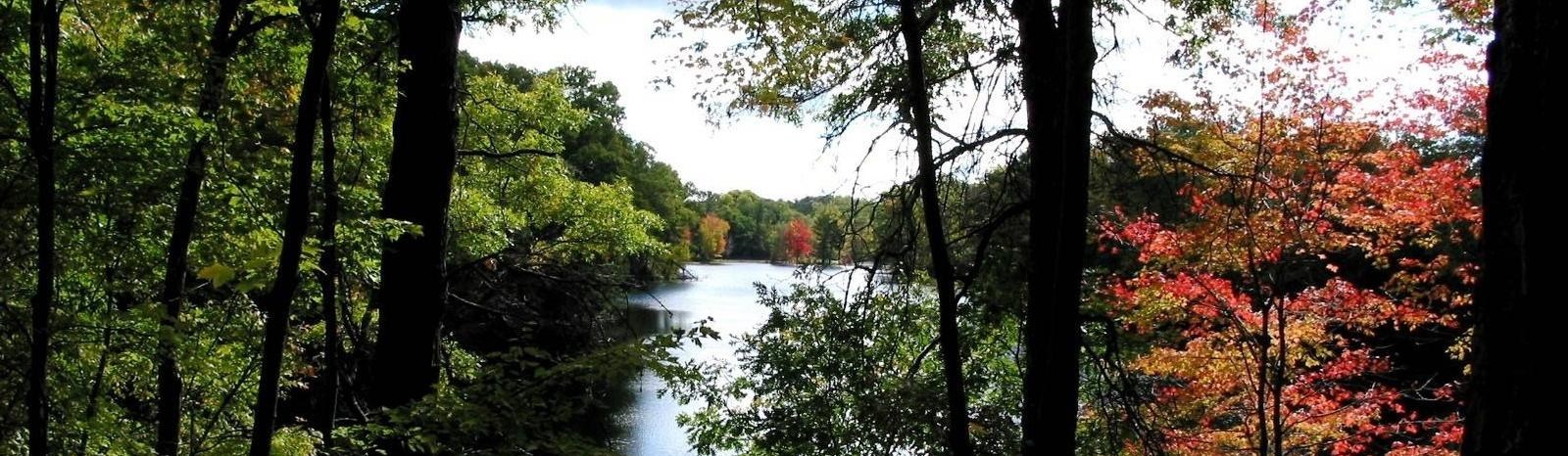 NPS photo | |
Wisconsin's Glacial Landscape
A mere 15,000 years ago, during the Ice Age, most of northern North America lay under the grip of colossal ice sheets. The effects of the advancing and retreating glaciers can be seen in the headlands of Cape Cod, the Finger Lakes of New York, and the hills of Michigan, but nowhere is the glacier's mark upon the land more impressive than in Wisconsin. Indeed, the State has lent its name to the most recent series of glacial advances and retreats—the Wisconsin Glaciation lasting from about 100,000 to 10,000 years ago.
Many times during the past 2 million years, a time also known as the Pleistocene Epoch, the climate has fluctuated between warmer and cooler temperatures. During the colder fluctuations, glaciers formed and spread outward from Arctic areas, engulfing most of northern North America. Each of the major glaciations has been followed by a warmer interglacial period, probably similar to that of today, during which the glaciers melted away.
The glacier most recently flowed into Wisconsin about 25,000 years ago and reached its greatest extent, covering approximately two-thirds of the State, about 14,000 to 16,000 years ago before melting back. The retreat of the ice front was interrupted a number of times by readvances; the last one touched northwestern Wisconsin about 10,000 years ago.
The advancing ice was channeled into the lowlands now occupied by Lakes Superior and Michigan, Green Bay, and the Fox River, and it was impeded by the uplands of the Bayfield, Keweenaw, and Door Peninsulas. The ice was thus split into six major lobes as it flowed across the State. The Green Bay Lobe, which had few obstructions in its path, penetrated as far south as present-day Janesville in Rock County.
The ice within the lobes was almost always sliding or creeping toward the edges of the glacier, even as it melted. As the ice moved, it froze around grains of sand, pebbles, and boulders, picked them up, and carried them along. Boulders that were carried great distances are called erratics. The material frozen into the base of the flowing ice gouged and scraped the land, leaving in some areas scratches, called striations, in the bedrock. In other areas streamlined, elongate hills called drumlins were formed. Wisconsin's State capitol sits atop one of these hills. Impressive clusters of them are found in the Campbellsport Drumlins Unit of the Ice Age National Scientific Reserve and in other areas, particularly southeastern Wisconsin. The striations and the long axis of the drumlins indicate the direction the ice flowed.
When the ice melted at the edges of the lobes, the sand, silt, cobbles, and boulders frozen in it were released and formed ridges called moraines. Even as the glacier melted back, ice usually continued to flow toward its edge, bringing more debris with it. Occasionally the flow stopped, the ice stagnated, and blocks of ice detached from the glacier were buried in debris. Many of Wisconsin's lakes lie in the depressions formed by the melting of the buried ice.
The moraines vary greatly across the State. Those in the southwest are usually dry, narrow ridges sitting atop the older hills at the edge of the unglaciated Driftless Area. Across the northern counties, the moraines form a broad band of hills and hollows—a poorly drained rocky landscape dotted with lakes, marshes, and bogs. The Chippewa Moraine Ice Age Reserve Unit is a particularly picturesque portion of these moraines, containing numerous depressions filled with lakes, bogs, and marshes. The moraine in Waushara County in the center of the State is similarly pitted with thousands of these depressions, but most of them are dry. The rugged, scenic Kettle Moraine in the eastern part of the State is actually a series of moraines formed between the Lake Michigan and Green Bay Lobes. The Green Bay Lobe also left a moraine in Sauk County which blocked both ends of a gorge in the Baraboo Hills creating Devils Lake. Some moraines stand no more than 30 feet above the surrounding terrain, but others in the Kettle Moraine rise to heights of 250 to 300 feet.
Streams flowing over, under, and beyond the glacier also left deposits that vary our landscape. The conical hills of water-rounded sand and cobbles called kames, that stud parts of the Kettle Moraine, are deposits of streams that flowed downward through cracks in the ice. The sinuous eskers, such as the one near the Mondeaux Flowage in Taylor County and the Parnell Esker in Sheboygan County, are ridges of rounded sand and gravel deposited by streams that flowed through tunnels at the base of the glacier. Like drumlins, they usually are aligned parallel to the ice flow.
The flowing meltwater spread fine layers of sand in broad plains, such as those in Langlade, Rock, and Portage Counties, that today are fertile cash crop farming areas. In several areas the meltwater pooled, forming large lakes where silt and clay collected. The flat bed of glacial Lake Wisconsin, one of these lakes, is a marked contrast to the unglaciated hills of the Driftless Area that bound its western side. In the Fox River Valley, Lake Winnebago and Horicon Marsh are small remnants of another proglacial lake—Lake Oshkosh.
The torrents of meltwater released from the wasting glacier or draining glacial lakes cut spectacular gorges in several areas of the State. Some, such as the Dalles of the St. Croix, the Wisconsin Dells, and the Dells of the Eau Claire, are still occupied by streams. Others, like the smaller gorge at the Cross Plains Ice Age Reserve Unit, are now dry except for spring and storm runoff.
Although many of these features are outstanding by themselves, seen as a whole they form a glacial landscape of remarkable beauty. The thousands of drumlins, kames, and kettles and the numerous moraines, eskers, and other features left by the fluctuating lobes of the last Wisconsin glacier appear very similar to features being formed by glaciers active today. The region of recent glaciation is dotted with over 14,000 glacial lakes; numerous bogs, marshes, and fens; and many streams whose courses are determined by the young glacial deposits. In a sense, this region of the State is still recovering from the melting of the last glacier. As the streams slowly wash away kames, eskers, and moraines, and as marshes, bogs, and lakes fill with sediment and organic debris, this young landscape will become like the older glacial landscape which lies between the Driftless Area and the terminal moraines of the most recent glaciation.
In the areas of Wisconsin that were glaciated prior to the most recent glaciation. erosion has had time to modify the landscape and, as a result, glaciai landforms are subdued or unrecognizable. Lakes and bogs are much less common in this older landscape. Most have either been drained by gradually lengthening streams, or filled with sediment that has accumulated over thousands of years. The result is a gently rolling landscape or nearly flat plains broken by occasional remnant hills or ridges. The remnants of glacial debris tell us these areas were glaciated long ago, but relatively little is known about their glacial history.
In striking contrast to both of these glacial landscapes stands the dry upland of southwestern Wisconsin known as the Driftless Area. Much of this region is a rolling upland plain, with no glacial sediment, that has been deeply cut by streams into a maze of narrow, twisting ridges and valleys.
There are few natural lakes, bogs, or marshes in this part of the State. Several prominent mounds, such as Blue Mound in eastern Iowa County, stand as erosion remnants well above the surrounding plain. This Driftless Area landscape has been forming for many thousands of years, whereas our most recent glacial landscape is but 15,000 years old or younger.
Wisconsin's legacy from the glaciers and meltwater streams of the Ice Age is a landscape of great diversity and beauty. The State's many lakes and ponds, forested hills and ridges, and gently rolling farmlands remind us of the glacier's visit and beckon us to come, explore, and enjoy!
A Trail To Explore The Glacial Landscape
Imagine a public greenway meandering across Wisconsin's glacial landscape. Imagine a trail 1,000 miles long leading both to places of glacial beauty close to home and to some of the remotest parts of Wisconsin. That is what the late Ray Zillmer of Milwaukee had in mind in the 1950s when he proposed that an Ice Age Glacier National Forest Park be established along the entire length of the moraines marking the furthest advance of the last glacier in Wisconsin. An avid hiker, he proposed a continuous footpath, similar to the Appalachian Trail, as the central feature of the park so that visitors could explore and enjoy the glacial landscape at their own pace.
In 1958, the Ice Age Park and Trail Foundation was established by a group of Wisconsin citizens to promote the creation of the national glacial park. As the effort to win Congressional authorization of the park gained momentum, volunteers were already at work building the first segments of the future Ice Age Trail in the Kettle Moraine State Forest.
The result of these efforts was the creation, in 1971, of a nine-unit Ice Age National Scientific Reserve to be administered by the State of Wisconsin in cooperation with, and with assistance from, the National Park Service. While the nine Reserve units contain only portions of the glacial park proposed by Zillmer, the Federal legislation authorizing the Reserve specifically recognized the efforts of the Ice Age Park and Trail Foundation to create a continuous footpath linking these areas, but offered no Federal assistance.
In 1975, an Ice Age Trail Council was formed and efforts to establish the trail accelerated across the State. In a few years, volunteers organized by the council were successful in establishing major segments of the trail. Congress recognized the national significance of the trail and the efforts to establish it in October 1980 by designating it a National Scenic Trail (NST). The National Park Service administers the trail in cooperation with the Wisconsin Department of Natural Resources and the Ice Age Park and Trail Foundation (which merged with the council in 1990 and became a general membership organization; name changed to Ice Age Trail Alliance in 2009). There are also many other partners that participate in the trail by developing and managing specific segments, including the U.S. Forest Service; county and municipal park and forestry departments: conservation, civic, and youth organizations; and private volunteers and landowners.
Changing land uses along the trail route and increasing development pressure made it obvious by the mid-1980s that a permanent right-of-way for the trail needed to be preserved. Consequently, the foundation began purchasing trail lands in 1986 with privately donated funds. The Wisconsin legislature also responded to the need to protect the trail by designating it Wisconsin's first State scenic trail in 1987. In the 2 years that followed, the legislature enacted two funding programs to assist in acquiring lands for the trail—the Ice Age Trail Match Grant Program and the 10-year Stewardship Program, a component of which is dedicated to the Ice Age Trail. The National Park Service, through its administrative authorities for the trail, leads the effort to plan the permanently protected route and identify the lands that need to be acquired.
Today, approximately 225 miles of the trail have been certified by the National Park Service as part of the Ice Age NST. Certification indicates the segment is developed and managed in accordance with approved trail plans and entitles the segment to be marked with the official trail emblem. An additional 250 miles of completed trail segments are also open for public use and enjoyment.
Enjoying the Trail
Because many different public agencies and private interests are participating in the development and management of the Ice Age NST, users must be mindful that the type and width of the trail tread, the support facilities available such as campgrounds, and rules and regulations governing use of the trail will vary from segment to segment.
Users of the Ice Age NST are urged to show their appreciation for the voluntary public and private efforts to develop and manage the trail by using it and related facilities properly and complying with any applicable rules and regulations. Users should be especially careful to respect the rights of private property owners, particularly those who have generously allowed the trail to cross their land. Please stay on the trail, especially when crossing private lands.
Trail Marking. Certified segments of the Ice Age NST are signed with a marker. These are supplemented by paint blazes (usually yellow) and routed wooden signs that provide distance and directional information. Other segments are marked similarly, but lack the official Ice Age NST symbol.
Permitted Uses. All segments of the Ice Age NST are open to travel by foot for hiking and backpacking. Other non-motorized uses, including bicycling, horseback riding, cross country skiing, snowshoeing, and jogging, may be permitted on a given segment according to the desires and policies of the managing authority responsible for the segment. In addition, certain segments are open to snowmobiling in winter. For information on which segments are open to other uses besides hiking, write to any of the addresses given below.
Fees and Permits. The use of some segments of the Ice Age NST and overnight facilities requires the payment of a fee and/or obtaining of a permit. Bikers, for example, must purchase a State Trail permit from the Wisconsin Department of Natural Resources to ride the Ahnapee, Sugar River, Tuscobia, Military Ridge, and Glacial Drumlin State Trails segments of the Ice Age NST. Fees are also required to camp in many developed Federal, State, and county campgrounds. Users should check with managing authorities in advance to determine if permits and/or fees are required.
Camping. Facilities for camping along the Ice Age NST vary greatly. Some managing authorities permit camping anywhere along the trail. Others permit camping only at designated sites. In some cases, the trail may already be open to use but designated camping sites have not yet been established. Along such segments it may be difficult to find any place to camp legally. Users are urged to plan their trip in advance to assure themselves proper overnight accommodations. Patience is needed while the trail is being developed. Above all, avoid trespassing and violating private property rights.
Interpretive Facilities. Major interpretive centers explaining the glacial history and geology of Wisconsin are located along the trail in the Northern Unit of Kettle Moraine State Forest, Interstate State Park, and Chippewa Moraine State Recreation Area.
Fishing. A Wisconsin fishing license is required for fishing in lakes and streams along the trail.
Hunting. Many public and private lands through which the Ice Age NST passes are legally open to hunting during the proper seasons. It is not intended that passage of the trail through these lands should in any way lead to their closure to hunting. Similarly, passage of the trail through lands closed to hunting does not open them in any way to hunting. In general, the trail will remain open to use during hunting seasons. However. some segments of the trail may be closed to use during some hunting seasons by the managing authorities responsible for those segments. Trail users should check in advance with the managing authority regarding use of specific segments during hunting seasons. Trail users are encouraged to wear "hunter's orange" while using segments open to hunting.
Additional Information. For specific information on segments of the trail on State lands, write to: Wisconsin Department of Natural Resources. Box 7921, Madison. WI 53707.
Information on trail segments on county, municipal, and private lands can be obtained from the Ice Age Park and Trail Foundation, P.O. Box 423, Pewaukee, WI 53072-0423.
Information on the segment in the Chequamegon National Forest can be requested from the Medford Ranger District, Chequamegon National Forest, 850 North 8th Street, Highway 13, Medford, WI 54451.
Requests for additional general information about the trail may be addressed to: Ice Age National Scenic Trail, National Park Service, 700 Rayovac Drive, Suite 100, Madison, WI 53711-2476.
You Can Help. While most parts of the Ice Age Trail that cross public lands have been completed, the major portions of the trail that must cross private lands remain to be developed. Your help is needed in establishing additional segments of the trail. You can help by joining the Ice Age Park and Trail Foundation and its local chapters and volunteering to assist in the effort to establish and maintain the trail. Donations of money, land, and easements for the trail are also needed. You can help complete the trail by giving a tax-deductible gift of this type to the nonprofit Ice Age Park and Trail Foundation, P.O. Box 423, Pewaukee, WI 53072-0423.
Description of the Trail Route
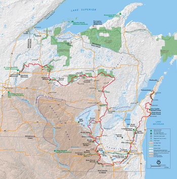 (click for larger map) |
The route of the Ice Age National Scenic Trail generally follows the end moraines of the most recent glaciation, although it diverges from them in several areas to include other features of the glacial landscape and a glimpse of the Driftless Area.
From its eastern end at Potawatomi State Park on Green Bay, the trail route follows in places the present and former shorelines of Lake Michigan, the crest of eskers, and the edges of bogs in Manitowoc County. In several long existing segments and in many short ones, the trail continues over the rolling upland of the Kettle Moraine on public and private lands for more than 100 miles through Sheboygan, Washington, and Waukesha Counties. From marshes to hilltop remnants of prairie oak openings and along waterways through oak, hickory, and maple forests, the trail threads its way among the many towns and villages of the densely populated southeastern portion of the State.
In northeastern Rock County, the trail route follows railroad corridors north of the end moraine. The trail then meanders through Janesville, utilizing its system of parks and greenways. In Green County, a segment of the trail follows the Sugar River State Trail, affording an opportunity to explore the eroded remnants of features left by the glaciers prior to the most recent Wisconsin Glaciation.
The trail route returns to the end moraine of the recent glaciation in Dane County, skirts Madison's western edge, and leads to several glacial meltwater channels cut into the bedrock hills of the Driftless Area, such as the one in the Cross Plains Unit of the Ice Age National Scientific Reserve. The resistant quartzite of the Baraboo Hills halted the glacier's advance in Sauk County and provides the greatest relief found along the trail—over 800 feet.
Just north of Devils Lake State Park, the trail divides. The western branch passes the Dells of the Wisconsin River, which were formed by glacial meltwater, and crosses the flat bed of glacial Lake Wisconsin in Juneau and Adams Counties, passing sandstone buttes rising among scrub oaks and jack pines. The eastern branch follows the moraines through Columbia and Marquette Counties and joins together with the western branch in Chaffee Creek Fishery Area.
Following the hummocky topography of the moraine in Waushara County, the trail route winds among numerous kettles and along the Mecan River and several other trout streams. The route swings east along moraines deposited as the glacial margin retreated, passes through drumlin fields and among kettle lakes in Portage and Waupaca Counties, and continues north across outwash plains and end moraines in Marathon County.
In Langlade County and the counties to the west, long segments of the trail have been established on county forest lands. Amid the northern forest of spruce, fir, maple, and birch in Langlade County, the trail enters a region full of lakes and bogs formed by the melting of the glacier. In the lake-sprinkled Harrison Hills of Lincoln County, the high point of the trait—1,875 feet—is reached on the shoulder of Lookout Mountain. Timm's Hill National Trail, a side trail in eastern Taylor County, leads north 10 miles to the Highest point in Wisconsin—1,951.5 feet—in Price County. While walking the crests of eskers in the Chequamegon National Forest in Taylor County, one gets a hint of what was once the great white pine and hemlock forest that provided the lumber to build the cities of the Midwest, and the tanbark for the leather industry in the late 19th and early 20th centuries.
In Chippewa County, the trail again winds among numerous lakes and bogs in the moraine of the Chippewa Lobe. Bearing north, the trail goes over the high quartzite shoulder of the Blue Hills in Rusk County amid small streams in an ash, birch, and maple forest. The northernmost point of the trail is reached in southeastern Washburn County along the Tuscobia State Trail at the Red Cedar River. The trail route winds through the dairy country of Barron and Polk Counties to its western end in the Interstate State Park Ice Age Reserve Unit at the Dalles of the St. Croix River.
Source: NPS Brochure (1993)
|
Establishment Ice Age National Scenic Trail — October 3, 1980 |
For More Information Please Visit The  OFFICIAL NPS WEBSITE |
Documents
A Toe in the Water: J Harlen Bretz's First Field Exploration of Eastern Washington's Channeled Scablands (John Soennichsen, extract from Columbia: The Magazine of Northwest History, Vol. 25 No. 1, Spring 2011; ©Washington State Historical Society)
Corridor Plan and Environmental Assessment for Eastern Chippewa County, Wisconsin, Ice Age National Scenic Trail (June 7, 2021)
Corridor Plan and Environmental Assessment for Rock County, Wisconsin, Ice Age National Scenic Trail (March 2023)
Final General Management Plan/Environmental Impact Statement, Ice Age Complex at Cross Plains (September 2012)
Foundation Document Overview, Ice Age National Scenic Trail, Wisconsin (January 2017)
Geology of the Ice Age National Scientific Reserve of Wisconsin (HTML edition) Scientific Monograph Series No. 2 (Robert F. Black, 1974)
Hiking Field Trip Guide for Glacial Landforms in Chippewa Moraine Ice Age National Scientific Reserve (P. Bement, H. Bohl, T. Hogue, K. Johnson, M.K. Yarrington, G. Michael, C. Schmmidt, S. Toshner and E. Weiland, March 1995)
Long-Range Interpretive Plan, Ice Age National Scenic Trail (October 2013)
The Great Columbia Flood (Tom Mullen, extract from Columbia: The Magazine of Northwest History, Vol. 19 No. 1, Spring 2005; ©Washington State Historical Society)
The History of Devils Lake, Wisconsin (Arthur C. Trowbridge, extract from The Journal of Geology, Vol. 25 No. 4, May-June 1917)
The Stonecutter & the Missoula Flood Erratics (Nathaniel D. Reynolds, extract from Columbia: The Magazine of Northwest History, Vol. 20 No. 1, Spring 2006; ©Washington State Historical Society)
iatr/index.htm
Last Updated: 01-Jan-2025