|
Katmai
Building in an Ashen Land: Historic Resource Study |

|
CHAPTER 4:
SCIENTIFIC EXPEDITIONS AND RESEARCH
EARLY SCIENTIFIC EXPEDITIONS and researchers were drawn to the Katmai region to study the effects of the 1912 volcanic eruption. From 1915 to 1919, Robert Fiske Griggs led the National Geographic Society's expeditions to Katmai. Their observations and documentation of the area, especially of the fumaroles, led to the creation of the Monument. For the most part, the expedition members set up temporary campsites. They did, however, build two storage cabins at their base camps, one located near Savonoski and the other on the west side of Katmai Bay. Some of the Society members also built rock cairns for surveying purposes. One other building related to scientific research is the Baked Mountain cabin that the University of Alaska's Geophysical Institute built in 1965.
Prior to Russia's sale of its American colonies to the U.S. Government, the scientific world had little interest in the Katmai area. The 1867 purchase of Alaska sparked an interest in knowing more about Alaska's resources, which spurred several investigations led by the Coast Survey and the Smithsonian Institution. The 1895 Becker-Dall expedition is considered to be the first attempt at a systematic investigation of the Alaska Peninsula's mineral resources. This was one of the first U.S. Geological Survey studies in Alaska. [1]
In 1898, the USGS expedition led by geologist Josiah Edward Spurr covered over a thousand miles, which included traveling from the Nushagak to Naknek Lake and on to Katmai. Spurr's report provided the only known geological observations of the Upper Ukak River valley prior to the 1912 eruption. [2]
National Geographic Society
Expeditions
In July 1912, the first of several National Geographic Society (NGS) investigations of Alaskan volcanoes began. George C. Martin, a USGS geologist, visited the Katmai coast by stopping at Douglas; he did not, however, venture inland. [3] The following year, NGS botanist Robert F. Griggs traveled to Kodiak to study revegetation of the ash deposits. [4] An independent exploration by William A. Hesse, of Cordova, and Mel A. Horner, of Seward, also occurred in 1913. That summer the two men made a reconnaissance of the Katmai area and were close enough to the edge of the volcanic district to convince Griggs upon their return that they had gotten a glimpse of thousands of small fumaroles. [5]
Between 1915 and 1919, the National Geographic Society sponsored five scientific expeditions to the Katmai area. Robert Fiske Griggs led four of these trips. Griggs, a Ph.D. from Harvard University, spent a great portion of thirty years devoted to exploring, promoting and protecting Katmai National Monument. As NPS historian John A. Hussey has summarized, "It is safe to say that during that period. no other man so greatly influenced the course of events in that vast scenic and scientific wonderland." [6]
The goal of the 1915 National Geographic Society expedition was to make a reconnaissance of the country west of Shelikof Strait. Griggs and two companions sailed from Kodiak to Katmai Bay. They visited Katmai village and noted the effects of the ash, pumice and the Katmai River flood on the buildings and structures. Their explorations took them to the lower slope of the Aleutian Range, from which they viewed the line of volcanoes including Martin, Mageik, Trident, and Katmai.

|
| "The party of 1915 at Katmai Village." From left to right: Robert F. Griggs; L.G. Folsom, Kodiak teacher; and B.B. Fulton, entomologist. Photo courtesy of University of Alaska Anchorage, Archives and Manuscripts Department, National Geographic Society Katmai Expeditions Collection, Box 1, 3785. |
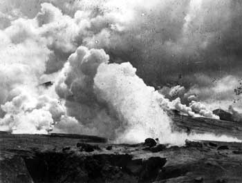
The following year, Griggs led an expedition of four men back to the Katmai mainland. One of the group members was Walter Metrokin, a one-handed bear hunter from Kodiak. They set up a base camp near Katmai Village. This expedition was significant for the discovery and documentation of fumaroles in the valley west of Katmai Pass. As Griggs recalled,
Even from this hasty examination we were able to make on the day of discovery, we could see that the vents must be counted by the tens of thousands. And from this first impression came the name, The Valley of Ten Thousand Smokes. [7]
|
| Photograph of fumarole at north angle of Baked Mountain, 1917. Photo courtesy of University of Alaska Anchorage, Archives and Manuscripts Department, National Geographic Society Katmai Expeditions Collection, Box 2, 1172. |
Griggs summarized his belief about the area. "I recognized at once, that the Katmai district must be made a great national park accessible to all the people, like the Yellowstone. To make it known, to have it set aside as a National Park, and to secure the means necessary for its development would, I foresaw, require a tremendous amount of effort." [8] This expedition provided the first purely scientific writings from observations made at Katmai.
The 1917 NGS Katmai investigation consisted of ten men and included a chemist, a zoologist, a topographer, and two assistant botanists. The men focused their scientific efforts on the Valley of Ten Thousand Smokes. A base camp was set up at on the west side of Katmai Bay, with supplies being transported across the lagoon. Goods were then carried over the south side of Katmai River and on up to the pass. They set up three subsidiary base camps on the western side of Katmai Pass and established a system of relay camps. The spent a month on the west side of Katmai Pass and traveled as far north as the end of the ash flow (which was almost to Savonoski). [9] The thousands of fumaroles were an awe-inspiring sight; as expedition member James S. Hine, a zoologist, commented,
Having reached the summit of Katmai Pass, the Valley of Ten Thousand Smokes spreads out before one with no part of the view obstructed. My first thought was: We have reached the modern inferno. I was horrified, and yet, curiosity to see all at close range captivated me. Although sure that at almost every step I would sink beneath the earth's crust into a chasm intensely hot, I pushed on as soon as I found myself safely over a particularly dangerous-appearing area. I didn't like it, and yet I did. [10]
|
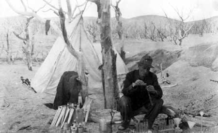
| "Chemical laboratory" near Trident Volcano, 1917. Photo courtesy of University of Alaska Anchorage, Archives and Manuscripts Department, National Geographic Society Katmai Expeditions Collection, Box 2, 1172. |
The work of 1917 provided material for the report that led President Woodrow Wilson to proclaim Katmai a National Monument on September 24, 1918.

|
| The National Geographic Society Katmai expedition members built rock cairns to use as survey reference points. This photo is titled "Station 24," which is believed to have been at or near the summit of Dumpling Mountain, 1918. Photo courtesy of University of Alaska Anchorage, Archives and Manuscripts Department, National Geographic Society Katmai Expeditions Collection, Box 4, 3614. |
The 1918 summer expedition consisted of only two men, Jasper D. Sayre and Paul R. Hagelbarger. They journeyed from Seward via the steamship Dora to Naknek and then up the river to the eastern end of Naknek Lake. Their goal was to study whether the fumaroles were as active as before and to ascertain the fumaroles' temperatures as well as to survey the area for a topographic map. While in the Naknek Lake area, Sayre and Hagelbarger visited the former Savonoski settlement and also built a rock cairn at or near the summit of Dumpling Mountain for use as a survey reference point. The men explored the foot of the Valley of Ten Thousand Smokes, the slopes of Mageik and hiked over to Novarupta. They took back the first accurate temperatures of the fumaroles.
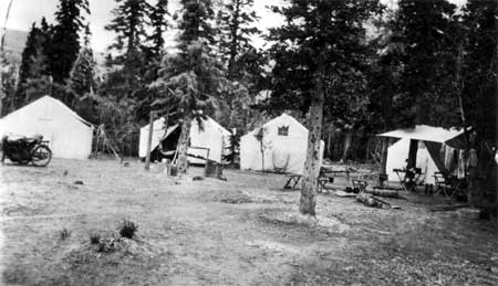
The largest NGS Katmai expedition occurred in 1919. That summer, Sayre and three of Griggs' students traveled with the bulk of the supplies to Bristol Bay with the assistance of Naknek Packing Company boats, then ascended Naknek River and crossed to the east end of Naknek Lake. Soon after arriving, they set up a base camp, named "Savonoski." The camp was located on the southern shore of Iliuk Arm, about a mile west of the Ukak River, among a few surviving black spruce. The camp consisted of several 12' x 16' mosquito-proof tents. They also built a rectangular shaped cabin, measuring 14' x 16,' with local hewn spruce logs and covered it with a metal roof. This was used for storing their provisions and supplies. [11]
|
| "Savonoski Camp" with motorcycle, tents, and "kitchen", 1919. Photo courtesy of University of Alaska Anchorage, Archives and Manuscripts Department, National Geographic Society Katmai Expeditions Collection, Box 6, 5658. |
|
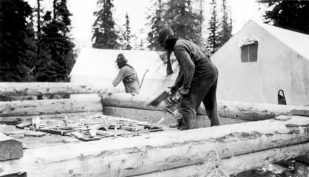
| Building the cabin at Savonoski Camp, 1919. Photo courtesy of University of Alaska Anchorage, Archives and Manuscripts Department, National Geographic Society Katmai Expeditions Collection, Box 6, 5658. |
In the meantime, Griggs led the rest of the party from Kodiak to the Katmai coast. Newcomers to the expedition included two chemists and a petrologist from the Geophysical Laboratory of the Carnegie Institution. [12] They set up the Lagoon base camp located on the western side of Katmai Bay and built a storage cabin using plywood boards. [13] Since they could not live off the devastated land, the group had to bring in all their supplies. [14] They established a series of relay camps across the peninsula by which they transported their supplies by backpacks.
As Griggs explained the process,
We would proceed half a day's march from our base, then establish a new camp at the terminus, returning each night to the starting point, until enough provisions had been accumulated to permit another move forward. In this way the packers drew their sustenance altogether from the rear camp, leaving the advance supplies intact for future use. [15]
|
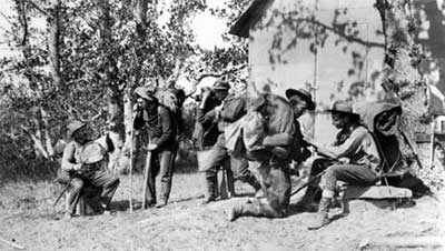
| Above: Party preparing to leave Lagoon Camp, 1919. Photo courtesy of University of Alaska Anchorage, Archives and Manuscripts Department, National Geographic Society Katmai Expeditions Collection, Box 6, 6254X. |
|
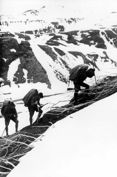
| Above: Climbing up the moraine on the way to Katmai Pass, 1919. The expedition carried guns as protection against the many bears who Griggs noted were drawn to the area, "...They [the bears] were not satisfied with merely crossing through the steaming areas, but were apparently attracted in some degree by the Smokes. Their tracks were often to be found close around the largest vents, even far up toward the head of the Valley, many miles from any possible source of food." (The Valley of Ten Thousand Smokes, 223); Photo courtesy of University of Alaska Anchorage, Archives and Manuscripts Department, National Geographic Society Katmai Expeditions Collection, Box 5, 5061. |
The base camps were, in a relative sense, more elaborate setups that included larger tents and the building of two cabins. For the most part, the other camps consisted of canvas pup tents supported by walking sticks or rifles, although at least a portion of a cabin was built at Ukak Camp. The expedition members also made use of local prospectors' or trappers' cabins around Naknek Lake, and they used a rock cave in Geographic Harbor for shelter as well. [16]
|
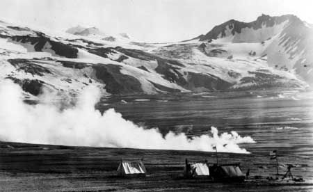
| Baked Mountain Camp with Mount Martin in the background, 1919. Photo courtesy of University of Alaska Anchorage, Archives and Manuscripts Department, National Geographic Society Katmai Expeditions Collection, Box 5, 5061. |
The Baked Mountain Camp was no doubt one of the expedition's toughest places for a campsite because of ferocious windstorms. The crew was blown out several times, and prior to the final storm they attempted to reinforce the tents. As Griggs noted,
The frame of the grub tent had been strengthened by a multiplicity of poles and braces sunk deep in the ground until it formed a veritable cage, inside of which we had patched together parts of four tents. Fully a thousand feet of cord had been used in lashing the structure together.
All the guys were anchored to bowlders as big as a man could roll, deeply buried in the ground. On every side except the front there were at least two thicknesses of cloth to protect us from flying pumice. A heavy duck tarpaulin had been thrown over the second tent and buried in the ground on the windward side, to reduce its resistance and prevent the wind from getting in under the eaves.

|
| Strong man stunts, 1919. Photo courtesy of University of Alaska Anchorage, Archives and Manuscripts Department, National Geographic Society Katmai Expeditions Collection, Box 7, 6414. |
Despite their efforts, a storm blew through, shredding their tents and snapping poles until the five men were left huddling together in the grub tent with sharp pumice stones raining down. They eventually managed to walk out of the area and down to the Ukak Camp although Griggs, for one, was literally picked up and sent flying through the air before the wind dropped him into a gully. [17]
The NGS party provided some basic geographic knowledge about the area. As a member noted about Lake Grosvenor, "That so large a body of water could have remained entirely unknown is significant testimony of how little is known of the geography of the Alaska Peninsula." [18] The NGS scientific expeditions made contributions in the fields of volcanology, geology, biology, and other subjects as well.
Later Research Efforts
Other scientific related activities have taken place in the park, although there are no historic properties related to them. During the 1920s-1930s, Father Bernard Rosecrans Hubbard, S.J. made several expeditions into the Katmai region. Hubbard, the famed "Glacier Priest," was a geology professor, explorer, filmmaker, lecturer, and author. In 1929, Hubbard, along with a group of university students and a film crew, successfully entered the Valley of Ten Thousand Smokes by way of Katmai Bay and over the pass. In 1932 he made the first wintertime ascent of Mount Katmai. [19]
In 1940 the National Park Service, having recognized the lack of information about Katmai's wildlife, sent biologist Victor Cahalane and Mount McKinley Superintendent Frank Been to Katmai. This was the Service's first concerted effort to have an inventory taken of the area's biological diversity. An additional NPS investigation, with a grant from the Office of Naval Research, took place during 1953-1954; it was known as the Katmai Project. The first year, a team of scientists included geologists, volcanologists, geomorphologists, archeologists, and a geographer, biologist, mammalogist, parasitologist, and entomologist. A surprising determination from the season's research was that Novarupta, not Mount Katmai, was the primary vent of the June 1912 eruption. Additional research done the following season included the finding that the thicker ashfall was located around Novarupta instead of Mount Katmai. This research cinched the conclusion made the previous year. [20]

|
| In 1917, the NGS expedition noted this "bread-crust bomb on the crater rim of Novarupta." The prevailing belief was that Mount Katmai was the site of the 1912 eruption. 1953 and 1954 NPS field studies, however, determine that the Novarupta vent, located six miles further west, was the real site of the eruption. Photo courtesy of University of Alaska Anchorage, Archives and Manuscripts Department, National Geographic Society Katmai Expeditions Collection, Box 2, 1137. |
Katmai also served as a unique training ground for U.S. astronauts. During the summers of 1965 and 1966, astronauts trained in the Valley of Ten Thousand Smokes. It was believed that the ashen landscape was similar to the surface of the moon. [21]
One other building in the park associated with scientific research activity is the Baked Mountain cabin. In 1962, the University of Alaska's Geophysical Institute commenced earthquake research, both seismic and volcanic, in Katmai National Monument. A few years later, Institute personnel wanted to expand their research activities to involve four scientists on the site at a time. To accommodate their housing, the Institute gained permission from NPS to build a field base camp just south of Baked Mountain. In 1965, staff built a 8' x 20' prefabricated plywood residence and workroom along with a 7' x 10' generator hut. The staff also installed two seismometers, one located just north of Baked Mountain and the other just south of the confluence of the Savonoski and Grosvenor rivers. At a later date, a storage shed was constructed at Baked Mountain and a third seismometer was installed in the Geographic Harbor area. [22]
In 1981 the University of Alaska Geophysical Institute established a short-period seismic station at Cape Douglas. In 1988, the station was taken over by the Alaska Volcano Observatory. As of 1992, this was the only AVO-operated seismic station in the park. In 1987, the USGS established an additional 12 seismic stations. In 1993, 16 stations were actively being used to collect data. [23]
Historic Properties Summary and
Recommendations
The National Geographic Society's Katmai expedition built Savonoski Cabin and Lagoon Camp Cabin. Following the expedition's use of the Savonoski cabin, trapper Richard Mitchell used this cabin as his residence in the mid-1930s (see Chapter 8). In 1940, Mitchell's cabin was visited by NPS personnel Frank Been and Victor Cahalane and was noted as being in good shape. In 1945, Grant Pearson's NPS report included the aerial observation of a log cabin with a tin roof located near the mouth of the Ukak River. The river, however, was cutting into the site and it appeared that cabin would eventually be washed out. No site visit to the Lagoon Cabin has been recorded. The NGS also built at least a portion of a cabin at Ukak Camp, ten miles south of Savonoski village. It is recommended that historic archeological investigations search for remains of the 1919 NGS cabins built at Savonoski, Ukak, and Lagoon camps.
|
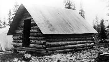
| The completed Savonoski camp cabin, 1919. Photo courtesy of University of Alaska Anchorage, Archives and Manuscripts Department, National Geographic Society Katmai Expeditions Collection, Box 6, 7468. |
Rock Cairns: The National Geographic Society Katmai Expedition members built rock cairns for surveying purposes. It is recommended that field notes that were used by members from 1915-1919 be researched to determine where rock cairns were built. A survey of these structures is then recommended to investigate what remains of them. One such survey marker was known to exist at, or near, the summit of Dumpling Mountain.
If historical archeological remains exist for the above features, it is recommended that a Multiple Property Documentation form be prepared to nominate these historic resources to the National Register of Historic Places. Such a form provides a streamline method for organizing and registering properties.
The Baked Mountain cabin, located just south of the mountain, was built by the University of Alaska's Geophysical Institute as a base camp for conducting their earthquake investigations in 1965. Twenty-five years later, in 1990, the cabin complex was refurbished. As this appears to be the only historic building within the Valley of Ten Thousand Smokes related to scientific research, a site visit is recommended to help determine if the structure is maintaining its historic integrity for possible future listing on the National Register of Historic Places.
Endnotes
1 Hussey, Embattled Katmai, 319.
3 George C. Martin's "The Recent Eruption of Katmai Volcano in Alaska," National Geographic Magazine (24 February, 1913), 131-81.
4 Hussey, Embattled Katmai, 372.
5 Griggs, The Valley of Ten Thousand Smokes, 71.
6 Hussey, Embattled Katmai, 382.
7 Griggs, The Valley of Ten Thousand Smokes, 192.
11 University of Alaska Anchorage, Archives and Manuscripts Department, National Geographic Society Katmai Expeditions Collection, Box 6, 5661, 5901, 7451.
12 Griggs, The Valley of Ten Thousand Smokes, 79.
13 University of Alaska Anchorage, Archives and Manuscripts Department, National Geographic Society Katmai Expeditions Collection, Box 6, 595; Box 7, 6254X; Box 8, 6575.
14 Griggs, in The Valley of Ten Thousand Smokes, 333, credits Kodiak storekeeper W. J. Erskine with supplying their whole outfit for two of the expedition years and Frank B. Petersen, president of the Naknek Packing Company, and his associates for assisting the 1918 and 1919 parties with their transportation and supplies via the Naknek River route.
15 Griggs, The Valley of Ten Thousand Smokes, 74-75.
16 University of Alaska Anchorage, Archives and Manuscripts Department, National Geographic Society Katmai Expeditions Collection, Box 6, H377, 5169, 7335, 7366, 7372, 7373, 7397; Box 7, 6305. The specific location of Ukak Camp in not known. Comtemporary maps suggest it was located either in T20S, R36W, Sec. 31, SW1/4 or T20S, R37W, Sec. 36, SE1/4.
17 Griggs, The Valley of Ten Thousand Smokes, 226-231.
18 University of Alaska Anchorage, Archives and Manuscripts Department, National Geographic Society Katmai Expeditions Collection, Box 5, 7142.
19 Norris, Isolated Paradise, 44-45. Hubbard's writings about his Katmai experiences include: Mush You Malemutes (New York, America Press, 1932); Cradle of the Storms (New York, Dodd, Mead, 1935); "Volcanoes Packed in Ice: An Explorer's Adventures in Alaska," Saturday Evening Post 203 (August 23, 1930), 18-19 and "The Heart of Fire Mountain," Saturday Evening Post 209 (July 30, 1932), 14-15.
20 Norris, Isolated Paradise, 381-384.
katm/hrs/chap4.htm
Last Updated: 22-Oct-2002