|
Kenai Fjords
A Stern and Rock-Bound Coast: Historic Resource Study |

|
Chapter 10:
RECREATION AND TOURISM
Early Recreational Trends
Before the Klondike gold rush began, there was little pressure on Alaska or Yukon game resources except in the vicinity of widely dispersed mining camps and cannery sites. The gold rush, however, lured tens of thousands of people northward. By 1900, Alaska had more than twice the population than it had had in 1890; its non-Native population, moreover, grew more than 750 percent during the same ten-year period. [1]
The Lure of the Kenai Peninsula Gamelands
|
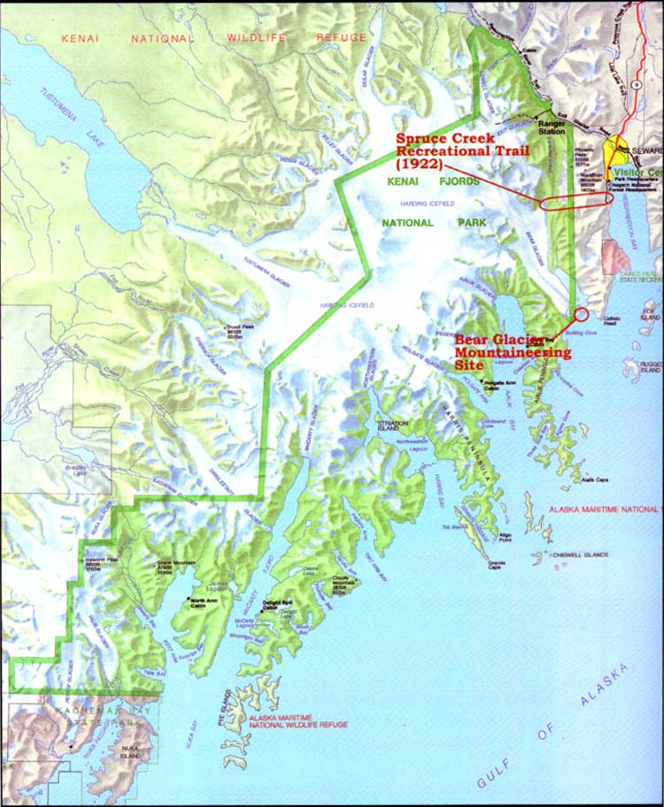
| Map 10-1. Historic Sites-Recreation/Tourism. (click on image for an enlargement in a new window) |
As a direct result of the gold boom, market hunters and individual prospectors fanned out across Alaska in search of game. The publicity that accompanied the gold rush also attracted trophy hunters, few of whom had visited Alaska previously. On the Kenai Peninsula, the Hope-Sunrise area had supported a growing population since 1894, and hunters were active along the Kenai coast during the mid- and late 1890s. As a result, the wildlife inevitably began to suffer. Dall De Weese, a hunter and travel writer, was able to count 500 sheep within six to eight miles of a spot in the Kenai Mountains in 1897; four years later, however, the number of animals had drastically declined. Similarly, hunter Andrew J. Stone noted in 1900 that "the Kenai Peninsula ... has been prolific in animal life but there are so many sportsmen now coming in that the large game is suffering quite a slaughter." (One author felt that non-resident sportsmen were a major culprit; although the game laws "allowed them to kill only two moose, three sheep, three bear, etc., [they] would kill all the animals they could lay their eyes on.") [2] Caribou were particularly vulnerable. Market hunters during the early 1900s exterminated the species in the Kachemak Bay area; in the years that followed, hunters were so successful in their endeavors that the last caribou were eliminated from the Kenai Peninsula about 1913. [3]
By 1905, both the Klondike gold rush and the Hope-Sunrise excitement had passed their peak, and as a result, pressure on the Kenai Peninsula game populations began to diminish. The Kenai, moreover, gained increasing fame as a sport-hunting destination during the years following the gold rush; by 1911, one source noted that it had "come to be regarded as the greatest game country in the possession of the United States." [4] Its popularity stemmed from its accessibility, the variety of local megafauna (specifically moose, sheep, bear, and goat), and the existence of many trophy-size animals. [5]
The gamelands, located in the hills and flatlands of western Kenai Peninsula, were reached via Kenai during the gold rush period. By 1905, however, construction of the Alaska Central Railroad had proceeded to the point that Seward became the primary entrepôt to the gamelands. Thereafter, most hunters who planned a Kenai Peninsula hunt sailed to Seward where they met a guide. They then took the train north to Kenai Lake, after which they sailed the length of the lake and floated down the Kenai River to the gamelands. As noted in a contemporary article, hunters looking for moose headed most often to Skilak Lake, Kenai Lake, Kenai River, [Lower] Russian Lake, the Chickaloon Flats, or "Kusiloff Lake." Sheep hunting areas included Sheep Mountain, False Creek, Stetson Creek, Skilak Lake, and Tustumena Lake. Goat hunters headed to the eastern peninsula, near Spencer and Bartlett glaciers, and both black and brown bears were scattered about the moose and sheep hunting country. [6]
By 1910, hunters throughout the world had heard about the Kenai Peninsula gamelands, and each year thereafter a smattering of hunters arrived in Seward. Some came for the spring bear hunt, while others arrived to take advantage of the fall moose and sheep hunt. The sportsmen hailed from all over the United States and from foreign countries as well, particularly from Europe. [7] The number who arrived each year was fairly small–usually just 10 or 15 parties totaling 25 or 30 hunters–but their wealth, their influence, and their penchant for publicizing their adventures via books and articles played a large role in broadcasting the Kenai's game resources. [8]
The Kenai Peninsula gamelands were essentially unregulated until May 1908, when Congress passed (and President Roosevelt signed) a law providing for major revisions to the Alaska Game Law of June 7, 1902. The 1908 law mandated that all Alaska hunting guides be licensed; in addition, the law recognized both the popularity and the fragility of the Kenai gamelands when it demanded that all Kenai Peninsula sport hunters be accompanied by a licensed guide. No other Alaska hunting grounds were singled out with this requirement. The law helped ensure the continuity of the Kenai game resource.
One beneficial effect of the 1908 law was that it brought forth a small corps of locally based guides, who gained fame (and some fortune) through their guiding efforts. By 1911, ten of Alaska's fifteen guides listed a Seward address. (The other five lived in Kenai.) Well-known guides living in or near Seward included Andrew Simons, Charles Emsweiler, Ben Sweazey, Bill De Witt, and Andrew Berg. Most if not all of these guides earned the respect of men who had hunted trophy animals throughout the world. [9] Another guide, who joined the ranks during the 1920s, was Luke Elwell. The Seward-bred guide lived in town for more than a decade; then, in 1939, he and his wife Mamie built a lodge at Upper Russian Lake and operated it for the next twenty years. The lodge was (and is) the first permanent habitation north of the present-day park boundary; it is also the largest structure between the park boundary and the Kenai River. [10]
One site along the hunters' route became a point of interest for tourists. Roosevelt, a station stop on the east side of Kenai Lake, had long been a transfer point and roadhouse for hunters heading west to the game country. Then, in August 1923, Nellie Neal announced that she had purchased the roadhouse. Neal, a former market hunter and cook in the railroad construction camps, soon married a Seattle electrician named William B. Lawing. The new Ms. Lawing, hoping to cash in on the expected boom in tourist travel on the recently completed railroad, cleaned out a building that was located in the narrow strip between the lake and the railroad right-of-way. Then, according to a local news report, she "placed her entire exhibit of fine Alaskan skins and furs on exhibit." The stop, which was renamed Lawing, became increasingly well-known; thousands of Alaska tourists (and residents) stopped there during the 1920s and 1930s. [11]
Seward Area Land Reservations
During the first quarter of the twentieth century, the federal government–specifically, the Interior and Agriculture departments–reserved land along the Kenai Peninsula's southern coastline. These actions may have prevented a broad range of development actions on the lands in question. Most of these withdrawals were the manifestation of events taking place away from southcentral Alaska. The reservations, however, were temporary, and they had a minor if not insignificant impact on Seward-area land use development. They have been presented in this chapter because the Interior Department has reserved several large blocks of Kenai Peninsula land in recent years; each of these actions, including the reservation that eventually resulted in Kenai Fjords National Park, was made to enhance recreational opportunities and preserve non-economic values.
The first agency to reserve a large area along Alaska's southeastern coastline was the Interior Department's Bureau of Forestry. In August 1902, President Theodore Roosevelt had proclaimed the establishment of the Alexander Archipelago Forest Reserve. The Bureau of Forestry administered this area, which comprised a portion of what is now known as Tongass National Forest. Roosevelt, well known as a conservationist, chose William A. Langille to head the reserve. Langille established a reserve headquarters in Wrangell, although he later moved to Ketchikan.
In 1904 and 1905, Langille made several long trips, at the behest of his Washington superiors, to inspect either recently withdrawn areas or areas proposed for withdrawal. One of those trips, beginning in September 1904, took him to Prince William Sound, where he made an examination the area's forest resources. He continued on to Seward, then headed overland to Kenai. He eventually wound up in Seldovia, where he boarded a coastal steamer and sailed back to Resurrection Bay. [12]
Langille, among his duties, was asked to evaluate the idea of a Kenai Forest Reserve. Those whom he encountered during his sojourn had mixed feelings about the proposal. A few recognized the importance of the forestry movement, and others (particularly along the railroad corridor) were opposed to the proposal, but most were indifferent. Langille himself reflected those sentiments; he noted that "The existing forest reserve law ... is too restricting and in a measure unjust to so new a country...." For that reason, he hoped that land would still be available for settlement in any new reserves. Given that caveat, Langille recommended the creation of a reserve that would encompass most of the northern and central Kenai Peninsula; specifically, he recommended that the reserve include the entire peninsula north of a line that connected Cape Puget (40 miles southeast of Seward) with "Coal Inlet" (Kachemak Bay). [13]
There was no immediate response to Langille's proposal. The Bureau of Forestry, meanwhile, underwent major structural change. In February 1905, the Bureau became part of the Agriculture Department; a month later, the bureau's name changed to the U.S. Forest Service; and in 1907, the agency changed the name of its forest reserves to national forests. [14] Historian Lawrence Rakestraw noted that soon after the establishment of the new agency,
there came a flurry of activity within the Forest Service regarding new reserves.... The Alaska reserves came up for consideration, and by March [1907] the Forest Service had decided to create new reserves, both in southeastern Alaska and in the Prince William Sound area.
President Roosevelt responded to that activity by proclaiming the Chugach National Forest on July 23, 1907. The forest, at this time, comprised just 4,960,000 acres, more than a million acres smaller than today; its western boundary snaked along the peninsula's eastern edge. Kenai Lake, the Quartz and Canyon Creek valleys, and the Hope-Sunrise area–all part of the Chugach today–were omitted from Roosevelt's 1907 proclamation. [15]
Just a few months later, in his 1907 annual report, Langille recommended that additional areas–primarily along Turnagain and Knik arms–be added to the Chugach in order to protect them from Alaska Central Railroad construction crews. That order was sent on to Washington, where it and other proposals lay until the closing days of the Roosevelt administration. On February 23, 1909–less than two weeks before William Howard Taft assumed the presidency–Roosevelt more than doubled the size of the Chugach, to 11,280,640 acres, the largest in the country. The proclamation, which institutionalized the boundaries that Langille had recommended in 1904, spread the previous boundaries of the national forest in several directions. It included all of the Kenai except for the area south of a sinuous line that connected Cape Puget with the head of Kachemak Bay (see Map 10-2). That line, for the most part, followed the drainage divide. Most of the Kenai Peninsula land not included in the Chugach, therefore, drained south into the Gulf of Alaska. The newly expanded forest included several thousand acres that are within the present park boundaries; almost all of that land is on the high-elevation portions of Harding Icefield. [16]
|
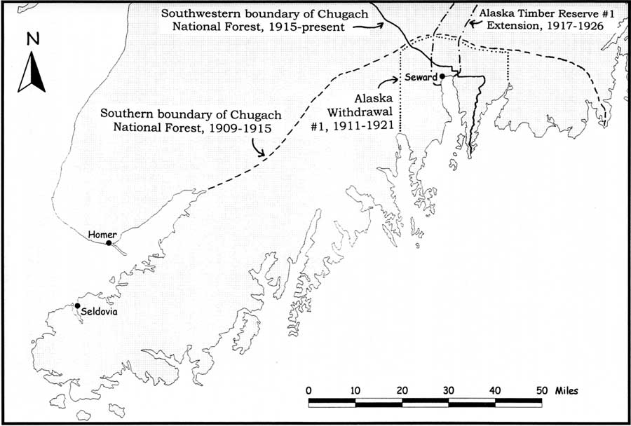
| Map 10-2. Seward Area Land Reservations, 1909-1926. (click on image for an enlargement in a new window) |
Sewardites did not hear about Roosevelt's action until several weeks into the new president's term. Local newspaper editor Leo F. Shaw was skeptical about the need for such an action. Shaw noted that "there is apparently little excuse for making a large forest reserve in this part of the territory of Alaska. There are practically no valuable forests in the section of the country included in the reserve." [17]
It is of more than parenthetical importance to note that Kenai's south coast was thrice considered for inclusion in Chugach National Forest. Forest Service historian Lawrence Rakestraw notes that the February 1909 addition had originally been planned to include the south Kenai coast, but commercial interests in Seward objected, so the crest of the range to Kachemak Bay was used. Two years later, in a report on the Chugach, Tongass National Forest head William Langille suggested that "the southern shore of the Kenai Peninsula from near Seward to the head of Kachemak Bay" be added to the forest. Then, in 1913, forester George Cecil visited the area and reported that the timber resources south of Kachemak Bay were superior to those north of the bay. Neither Langille's nor Cecil's observations, however, resulted in boundary modifications. [18]
On December 5, 1911, the federal government declared a land freeze in the Seward area. In anticipation of "future legislation" (which was probably the Congressional act of August 24, 1912, which authorized a commission to study various rail routes to the interior), the General Land Office established Alaska Withdrawal #1. The newly-designated land, which was "withdrawn from settlement, location, sale, or entry," stretched along the coast from Day Harbor to Aialik Bay; it included all land south of the recently expanded Chugach National Forest boundary, and several thousand acres in the present park. That executive order was modified in August 1912 to allow the "use or disposition of timber" within the recently withdrawn land. This latter provision was probably implemented to make the area's wood resource available to government rail construction crews. [19]
The General Land Office continued to be concerned about timber resources. In the summer of 1915, it created the huge Alaska Timber Reserve #1 in the Susitna and Nenana river drainages to ensure an adequate timber supply for the railroad construction crews. In April 1917, that reservation was extended to include a tract five miles on each side of the government railroad from Seward to the Knik River. The latter action included within its scope a few thousand acres currently included within Kenai Fjords National Park. [20]
Even before the three reservations had been created, action to nullify them had begun. In 1913, Alaska Delegate James Wickersham submitted a U.S. House bill to abolish the Chugach National Forest because of its relative lack of timber; a short time later, the newly created Alaska legislature passed a resolution in support of Wickersham's action. The General Land Office, perhaps in response, decided to tailor its boundaries to more closely circumscribe timbered lands. The agency recognized that "the public good will be promoted by adding to the Chugach National Forest ... certain lands, and by excluding certain areas therefrom and restoring the public lands therein." It prepared a proclamation to that effect, and on August 2, 1915, President Woodrow Wilson signed the proclamation that, on the Kenai Peninsula, modified the Chugach's boundaries to resemble their present configuration. (This action added to the forest the large tract of land on the northeast side of the Resurrection River, but eliminated the huge area in the western Kenai north of the coastal drainage divide.) [21] The following year, forester Asher Ireland visited the Seward area and recommended that 8,641 acres on the southwest side of Resurrection River be added to the forest. Ireland considered the parcel, which contained 42 million feet of spruce and hemlock, valuable both for both timber and protective cover; it had, in Ireland's opinion, "the best body of timber in southwestern Alaska." [22] Ireland's recommendation, however, was not enacted into law.
During the 1920s, the other reservations were eliminated, probably at the urging of local authorities. Seward Senator L. V. Ray sponsored a joint memorial in the 1919 Alaska legislature requesting the "restoration or modification" of Alaska Withdrawal #1. The General Land Office, in response, "appreciated that most of the reasons for the withdrawal have ceased to exist," but it was not until May 1921, with construction of the government railroad nearly completed, that Alaska Withdrawal #1 was "vacated and annulled" by President Warren Harding. Five years later, in November 1926, President Calvin Coolidge issued a similar executive order revoking Alaska Timber Reserve #1 on the Kenai Peninsula. Except for land in the newly reduced Chugach National Forest, most if not all of the Kenai Peninsula was now open, once again, to location and entry. [23]
Although the federal government appears to have paid an extraordinary amount of attention to the Seward area's forestry resources during this period, there have been no known attempts or proposals to secure timber for commercial purposes in or near the present park boundaries. Isolation, inaccessibility, the lack of potential board feet, and the lack of markets all help explain the absence of commercial timber operations. [24]
Visitors to the Southern Kenai Coast,
1900-1940
Early Sightseers and Hunters
Both sightseers and hunters have been attracted to the Seward area since the earliest years of the twentieth century. Tourists, to be sure, were few and far between during the first decade after Seward's founding. Most of the visiting hunters, moreover, were merely passing through on their way to the western gamelands.
Seward's earliest residents were well aware of Resurrection Bay's tremendous scenic attributes, and less than a year after the town's founding, the bay was being used for recreational sailing trips. [25] These trips probably continued, on an intermittent basis, for years afterward.
Relatively few people sailed along the outer coast during the twentieth century's first decade, but some of those that did were well aware of its scenic beauty and tourist potential. Ulysses S. Grant and D. F. Higgins, Jr., two government geologists, sailed the Kenai coast in 1909 and were thunderstruck at what they saw. In a 1913 monograph they wrote, "It is hoped that this publication may attract attention to some of the most magnificent scenery that is now accessible to the tourist and nature lover." [26]
During this period, Alaska tourists were seldom seen outside of the southeastern "Inside Passage" route, and those who sailed "to the westward" were a rare sight indeed. The decision to build a government railroad, and the line's subsequent construction, however, took place at the same time in which tourists were showing an increased interest in Alaska as a destination. As a result, tourism became increasingly evident in Seward and other southcentral ports during the years that immediately preceded World War I. Beginning in 1912, the Alaska Steamship Company advertised trips into the area. The advertisements apparently met with some success, and when the Pacific Steamship Company–the successor to the Pacific Coast Steamship Company–began operations in 1916, it too advertised for tourists. The World War I years were particularly successful for Alaska tourism because European travel was prohibited. Thus, it is highly likely that an increasing number of tourists during this period visited Seward, Kodiak, Seldovia, Anchorage, and other southcentral ports. [27] The route for some of these ships–both from "Alaska Steam" and from "the Admiral Line"–undoubtedly paralleled the outer Kenai coast. The route for the large steamships, however, took passengers on a more southerly route, away from the coast. Clouds and storms, moreover, often obscured the view. For these reasons, the few tourists who may have been aboard these ships saw only an occasional, distant glimpse of the outer Kenai coast. [28]
Hunters were also attracted to the area. As noted above, hunters from around the world passed through Seward each spring and fall on their way to the famed western Kenai gamelands. But others hunted locally. In February 1907, lands within the present park received favorable publicity when an article by local hunter Edwin Lowell was published in Recreation Magazine. The article concerned a moose hunt that he and a fellow Sewardite had taken "around the head of the Resurrection River" the previous September. [29]
Hunting was a popular pastime among Seward residents, and in October 1910 sufficient numbers of them gathered to organize the first of several "big game hunts." In this activity, local hunters were divided into teams; the teams received points according to the species of game that they obtained during the restricted time of the contest. Upon hearing of the contest, eastern big game hunters howled in protest, fearing a wholesale slaughter of game. The protesters were told, however, that the participants all adhered to the game laws and that all meat obtained was either consumed or put into storage for future use. The Seward Outing Club, which may have been an outgrowth of those hunts, was well established by 1914; it was one of a series of organizations that had been formed in the early twentieth century in towns along the southcentral Alaska coast. [30] Available evidence suggests that the vast majority of hunting by Seward residents during this period took place within a few miles of town or near the railroad right-of-way. As has been detailed below, an insignificant amount of sport hunting took place within the present park boundaries.
Rockwell Kent's Visit to Renard Island
|
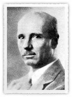
| Rockwell Kent, a budding author and artist, spent the winter of 1918-1919 at a fox and goat farm on Renard Island in Resurrction Bay. Current Biography, 1942, 447. |
In August 1918, a relatively obscure writer and illustrator named Rockwell Kent and his nine-year-old son sailed into Seward and checked in at the Sexton Hotel. The elder Kent, aged 36 at the time, had studied architecture and art; upon leaving school, he became an adventurer. When he arrived in Seward, he was not a tourist. Instead, he came to Alaska, in part, because he was a free-hearted spirit. And because he loved German literature and culture, he also sought a refuge from the jingoistic, anti-German sentiment then rampant in the United States. In addition, he noted,
I came to Alaska because I love the North. I crave snow-topped mountains, dreary wastes and the cruel Northern Sea with its hard horizons at the edge of the world where infinite space begins. Here skies are clearer and deeper and, for the greater mystery of those of softer lands. [31]
More specifically, Kent chose to visit Seward because he "did have a love for the isolation and wonder of island life," and he ideally sought a location "that combined the quiet dignity of the primitive forest with the excitement of the ever-changing ocean." [32]
He found such a location soon after he arrived. While rowing in the bay, he and his son met a 71-year-old fox and goat farmer named Lars Matt Olson. During the course of their conversation, Olson invited the two to visit him on Renard (Fox) Island, and on August 28, the two moved into a cabin near Olson's residence. Kent and his son remained on the island for more than seven months; the elder Kent spent much of that time writing, drawing, and enjoying a simple, primitive existence. The illustrated narrative of his experience, which he called Wilderness; A Journal of Quiet Adventure in Alaska, was Kent's first published book–and one of his best. The New York Times called it a "very beautiful and poignant record of one of the most unusual adventures ever chronicled;" it has also been called "a unique book and [an] unrecognized classic in the tradition of Henry David Thoreau's Walden." The woodcuts with which he illustrated the volume were notable as well; the public reportedly "gobbled up his work" when it was exhibited in New York. One biographer has noted that "With the appearance ... of his 64 Alaska drawings, Kent suddenly became one of the top-notch illustrators. His illustrations, in subsequent years, ... have become collectors' items." Critics also praised the book for its deft interplay of text and illustration; according to Frank Getlein, "many critics consider [Wilderness as one of] the best American books ever produced in terms of harmonious balance between text and pictures." [33]
|
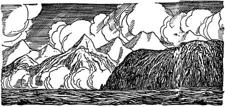
| Illustration by Rockwell Kent from his book Wilderness: A Journal of a Quiet Adventure in Alaska, 1920. Courtesy The Rockwell Kent Legacies. |
Kent appears to have savored his life on Renard Island during most of his sojourn, and he wrote extensively about the snow, wind, cold, isolation, and other elements of his immediate surroundings. The book made no attempt to soft-pedal the surrounding climate and topography, elements that were far more similar to the fjord country to the west than of Seward and the surrounding railbelt. (Caines Head, for example, was "a merciless shore without a harbor or tending place;" Bear Glacier was a place from which "the winds blow forever fiercely and ice cold;" and Renard Island itself was "warmer and much wetter [than Seward], and even the wind blows there when Seward's waters are calm.") Kent, during his stay, never ventured within the boundaries of the present park; the closest he came was a yearning to visit Bear Glacier that manifested itself during a visit to nearby Sunny Cove. He did, however, complete paintings of the present park coastline; one features Bear Glacier, while another looks from Renard Island toward Resurrection Bay's western shore. [34]
Kent, artistically and spiritually, appears to have embraced his experience on the island. Shortly after leaving, he exulted, "Know, people of the busier world, that there on that wild island in Resurrection Bay is to be found throughout winter and summer the peace and plenty of a true Northern Paradise...." [35] The popularity and the positive tone of Kent's reminiscence, however, did not result in increased tourism to either Alaska or the Seward area, for two reasons. Kent's book, successful as it was, appealed primarily to a small, literary audience. [36] In addition, almost everyone that visited Alaska during this period demanded the modern-day amenities that steamship travel provided; tourists thus had little interest in emulating Kent's strenuous, primitive experience.
Renard Island, and other points in southern Resurrection Bay, were fairly popular visitor destinations both before and after Rockwell Kent spent his winter there. Several visited the island, either on day trips or on overnight camps, while others sailed "down the bay" without disembarking. Several Sewardites, to be sure, paid social calls on Kent (and Olson) during the winter of 1918-19, but few latter-day tourists were so captivated by Wilderness that they felt the need to visit the island where they had resided. The cabin in which Kent and his son lived eventually collapsed. Today, there are almost no physical remnants of the cabin where the Kents stayed, and a tourist lodge was built in the mid-1990s on the Olson cabin site. [37]
Seward Becomes a Tourist Node
After World War I, the Alaska tourist trade boomed. The number of tourists increased almost every year from 1918 (when the war ended) through the late 1920s. Although there area few statistics that describe the industry during this period, the number of tourists that sailed to Alaska each year probably doubled, and may have tripled, during the decade that followed the cessation of World War I.
One of the most dramatic tourist growth areas was southcentral Alaska. Prior to the war, the only maintained routes in the region were the Valdez-Fairbanks Trail, the Copper River and Northwestern (CR&NW) Railroad, the Alaska Northern Railroad (which operated, on an intermittent basis, for only 72 miles), and a broad network of sled roads and winter trails. But by 1919, the trail between Valdez and Fairbanks had been improved into the Richardson Highway; and, as noted in Chapter 5, the U.S. government purchased the Alaska Northern line and extended the railhead hundreds of miles northward. With the exception of a bridge over the Tanana River, the so-called Alaska Railroad was completed all the way to Fairbanks in early 1922. Most tourists, however, did not begin to travel over the line until the summer of 1923. [38]
The completion of the line gave the prospective visitor to southcentral and interior Alaska an increasing variety of tour choices. A few tourists, as before, remained on board the coastal steamers, disembarking only for day trips in the vicinity of ports. Most people, however, chose to head inland. Tourists opting for a short trip inland disembarked in Cordova, took the CR&NW north to Chitina, boarded an auto stage and rode to Willow Creek on the Richardson Highway. They then continued on to Thompson Pass and Valdez, where they resumed their steamship journey. [39]
Those opting for a longer trip in southcentral and interior Alaska chose the Golden Belt Tour. Passengers on this tour rode the CR&NW north from Cordova to Chitina, where an auto stage awaited them for a trip north to Fairbanks. (Others began their inland trip in Valdez and took an auto stage all the way to Fairbanks.) Once in Fairbanks, tourists boarded the recently completed Alaska Railroad and rode south to McKinley Park, Anchorage, and Seward. Some tourists took this tour in reverse order; in either direction, it was a popular tour for almost twenty years. Those who wanted to avoid the travails of the Richardson Highway opted for the All-Rail Tour, an excursion on the Alaska Railroad from Seward to Fairbanks and return. [40]
Those who hoped to see the north country in a more leisurely manner–and could afford to do so–chose the Grand Circle Tour. Tourists taking this tour package disembarked at Skagway, rode the White Pass and Yukon Route railroad to Whitehorse, and sailed down the Yukon River on a WP&YR boat to Dawson. From there, tourists continued down the Yukon on an Alaska-Yukon Navigation Company steamer to Tanana and Fairbanks, and then rode the Alaska Railroad south to Seward. This tour required more than three weeks of inland travel. It could be taken in reverse order as well, although that option was longer (and more expensive) because of the slower pace of upstream travel. [41]
Because it was a leading Alaska port, Seward had been dealing with visitors ever since its founding. Hunters, most of whom hailed from Outside points, had been streaming through town for years; they used local accommodations, and some of them bought their outfits in Seward as well. The spate of tourists that invaded after World War I, however, had different needs and expectations than any previous group; they made local citizens aware, many for the first time, of the area's tourist attractions and facilities.
Seward residents, to be sure, had been enjoying outdoor pastimes for years; available activities included bear and moose hunting, berry picking, water sports, picnicking, vacation cabins, and mountaineering. Tourists, however, were less willing to "rough it" than locals, and most needed guides and a large-scale form of transportation. But because tourism was such a minor industry, the only local tour was a rail excursion north to Kenai Lake, which had been offered on an intermittent basis (to hunters and fishermen as well as tourists) since the days when the Alaska Northern operated the line. [42] By the early 1920s, tourists were also given the option of taking an auto stage north on the as-yet-uncompleted road to Kenai Lake.
In 1922, Seward development interests investigated a new way to stimulate local tourism. Before this time, local residents had ignored the huge, unnamed ice cap located west of the city. But in March 1922, it was announced that the "monster glacier near here" would "be used as an attraction for tourists this summer." In order to stimulate interest, the Seward Gateway asked local residents to name the feature. One suggested that it be named after Warren Harding, the current chief executive. Harding had made no secret of his interest in Alaska; he had publicly expressed his interest in visiting the territory as early as April 1921 and still planned to do so. Gateway editor E. A. Rucker therefore concluded that "some honor could be shown him by naming this great glacier after him." By April 1922, someone in Seward–perhaps Rucker himself–had decided on the name Harding Icefield. [43]
At first, locals were given few hints about how the nearby ice cap would become a tourist attraction. But in late April, acting mayor Harry E. Ellsworth announced that local businessmen would fund the construction of a trail from Seward south to Lowell Point, and from there up Spruce Creek. The trail would continue over the drainage divide to the eastern edge of Harding Icefield. Promoters felt that the so-called Spruce Creek Trail would have economic benefits because at its terminus, "one hour and fifty minutes walking time" from Seward, tourists could "actually stand on a glacier and be carried across the great body of snow and ice in dog teams. [This would be] a novelty they cannot enjoy anywhere else in the summer time," an attraction that would "prove a great drawing card for tourists." [44]
Local resident Eric Nelson began constructing the trail in mid-July, and by August 12 the trail was complete. Several hikers assayed the route that summer, at least as far as the drainage divide. [45] By all accounts, the trip was awe-inspiring. Local resident D. C. Mathison, who ascended the trail in late July, positively gushed about the glacier as viewed from the ridgeline:
But it is to the west, that ever mysterious west, [where] the greatest attraction lies. Near at hand are deep gorges, glacier-torn mountains, heaved and twisted ridges, smooth and placid lakes, whose shores when not covered with snow are literally strewn with vari-colored stones and pebbles.... In the not too great distance is the vast expanse of Harding glacier.... I am perfectly sure that anyone obtaining a view under the ideal conditions which obtained when I was there, whose very soul was not stirred, who fails to bow in humble acknowledgement of the puniness and insignificance of man, is bereft of one of Nature's greatest gifts — appreciation! Its gigantic size, its monstrous shape, its forbidding appearance, whose frigid bosom only the most rugged and uncompromising peaks have dared to defile.
But I am wasting time in attempting to describe. You should have been where I sat, have this great panorama before you, which to be appreciated must be seen. Only a geologist could tell what has caused the topsy-turvy appearance of the whole country. None but an artist could, with the delicate strokes of his brush and the blending of his colors, do justice to its beauty. No one but a poet endowed with the descriptive language of Shakespeare, the weird imagination of Poe, the rollicking language of Burns or the wholesome simplicity of Edgar Guest, could describe its wonders and its beauties. [46]
The trail remained in use for years afterward. By the spring of 1924 a shelter cabin had been built at the trail summit. That summer, local resident Jo Hofman "arranged dog sled rides ... so tourists could enjoy a unique outing on the glacier." There is little evidence, however, that tourists braved the long, steep trail to ride on dog sleds. Most of those who hiked up the Spruce Creek Trail, in fact, were probably local residents; after 1926, tourist materials no longer advertised the trail. [47]
A more popular way to ascend the slopes west of Seward was the Mount Marathon trail. Since 1916, Mount Marathon had been the site of a July 4 race; a few participants each year, all from Seward, had scrambled up the slopes to Race Point before sliding and tumbling back into town. With the growth of tourism, however, locals began to recognize that non-racers would also like to ascend the mountain because it offered the climber a magnificent view of the town, Resurrection Bay, the outer islands, and the nearby mountains and glaciers. In June 1925 a visitor from Seattle, Ben Poindexter, suggested that he and a group of volunteers blaze such a trail. A trail up the face of the mountain was roughed out that year; it proved popular, both with visitors and local residents. [48]
During the 1920s, many Seward-area tourist attractions were developed in addition to the two trails noted above. In November 1923, for example, the road from Seward to Kenai Lake was completed, and in the years that followed, many Seward visitors took the half-day excursion out to Kenai Lake. [49] In downtown Seward, civic authorities established a waterfront park; complete with fountains and a Russian cannon, its purpose was to ensure that "visitors would find a pleasant scene when arriving by ship or train." Seward residents were proud of the new tourist amenities. Historian Mary Barry notes that on some sunny summer days during the 1920s, "Seward was practically deserted ... as beautiful weather lured the residents to the forests–some to hike the Spruce Creek trail, others to climb Mount Marathon, and the rest to motor to Kenai Lake." [50]
In the summer of 1923, Seward was briefly in the world spotlight when President Harding visited the port as part of his Alaska tour. On July 13, Harding arrived in Seward on the Navy cruiser Henderson; he mingled briefly with the townspeople, then headed inland on a waiting train. At Nenana, he paused long enough to tap in the "golden spike" commemorating the Alaska Railroad's completion (a feat that had been accomplished several months before), then continued on to Fairbanks. By July 17 he was back in Seward; two days later, the presidential party steamed down the bay and headed toward Valdez. [51]
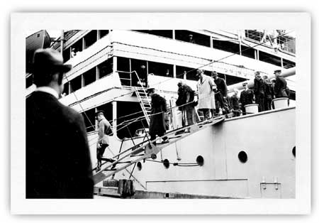
|
| In July 1923, President Harding and his wife visited Seward. Harding is shown in a light-colored coat at the top of the gangway; his wife is in front of him. Neville Public Museum, photo 5658.4 |
Beyond the publicity it shed on Alaska in general and Seward in particular, the trip was notable to the project area in several respects. Harding was particularly impressed with both Seward and Resurrection Bay. He called Seward "a rare gem in a perfect setting." As to the bay, Governor Scott Bone advised Harding that Alaskans wanted to bestow his name on some physical feature. Bone suggested naming a glacier or mountain after him, but Harding, after entering Resurrection Bay, told him that "of all the beautiful scenery and interesting objects we have passed, I would rather have this entrance perpetuate my name than anything else I could imagine." Within an hour, Bone issued a proclamation naming it the Harding Gateway. [52] In addition, the Seward Gateway named the huge icefield west of town in his honor (an action that, as noted above, had first been accomplished several months earlier). Harding himself probably saw no more of the icefield than a glimpse of Bear Glacier, but the Henderson crew saw the icefield in greater detail. The crew spent several days in port while the President's party toured the Alaska interior; on one of those days, local resident Mel Horner guided the crew, a few townspeople, and several tourists south on the newly-constructed Spruce Creek trail. Judging by contemporary press reports, the party hiked to the watershed divide and continued all the way to Harding Icefield before returning to town. [53]
The Alaska Railroad, in conjunction with the various tour packages, developed several Seward-based tourist excursions during this period. In 1926, it revived its Kenai Lake rail tour, using as its northern destination a visit with Nellie Neal Lawing at the Lawing wildlife museum. That same year, rail tourists were given the opportunity to take a day trip to Spencer Glacier, 52 miles north of Seward; the glacier here was within easy walking distance of the train. And in 1927, tourists on a two-day Seward layover were given an opportunity to visit Anchorage. The popularity of these excursions was mixed. The Lawing excursion lasted until 1931, and the Spencer Glacier trip remained until 1935. These two side trips, and the Anchorage excursion as well, had the practical effect of diminishing prospects for Seward-area tourism development. [54]
Relatively few Alaska tourists prior to World War II traveled independently (that is, apart from an advertised tour package). For that reason, relatively few out-of-state tourists had more than a few hours' free time while in Seward. Despite that limitation, it appears that some tourists, as well as some Seward-area residents, enjoyed taking boat trips on Resurrection Bay. In 1923, for example, local resident Howard Long advertised his motor boat as being available "for hunting or pleasure trips." The following spring, an article advertised boat trips on the bay for tourists, and a self-styled vacation guide issued in August 1926 urged Seward visitors to "take a motor boat ride to Fox Island." [55] In all probability, small numbers of visitors, primarily from Seward, continued to take Resurrection Bay boat rides each summer from the mid-1920s through the late 1930s.
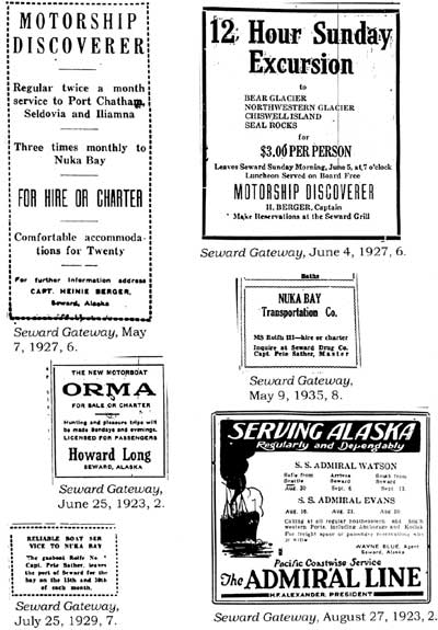
|
| Advertisements such as these lured early adventurers to the fjord country. |
Tourists and Hunters Visit the Coastal Fjords
As noted above, visitors have been passing through Seward ever since the town's founding in 1903. Hunters, furthermore, have been prominent since early days as well; Outside hunters headed through town on their way to Kenai Lake and the western Kenai gamelands, while Seward residents hunted on the outskirts of town and north within a few miles of the road or railroad. So far as is known, tourists and hunters prior to World War I largely ignored the southern reaches of Resurrection Bay, and virtually no recreationists spent time within the present park boundaries.
The first known recreational visit into park waters ended in tragedy. In October 1917, William G. Weaver and Benjamin F. Sweazey, the latter a licensed game guide, headed toward Aialik Bay on a bear hunt. When they did not return as scheduled, search parties were formed. Before long, the men's boat was found, bottom up, near Bear Glacier. No trace of the men was ever located. [56]
Over the next few years, a few Seward residents began to hunt in the coastal fjords. Charles Emsweiler, a local guide whose reputation was well established by 1913, took clients to the western peninsula gamelands. On his own, however, he hunted in a wide variety of locales, and in June 1919 he and his wife concluded a hunt in Nuka Bay, where they harvested three black bear. Three years later, the couple repeated their adventure. [57]
During the early to mid-1920s, occasional hunting parties–perhaps just one per year or even fewer–hunted within the present park boundaries. In May 1921, for example, local resident Jack Matsen headed down to Bear Glacier on what turned out to be an unsuccessful bear hunt. Two years later, the Gateway noted that "a party composed of Mrs. J. H. Flickinger, Andy Simons and wife, Frank Revelle and Milton Noll left today for down sound points where they will engage in a bear hunt." Occasional hunters also headed up into the Resurrection River valley; in August 1920, three Army privates ascended the valley at least as far as Redman Creek. [58]
Tourists–that is, recreationists who were not interested in hunting–were not known to frequent the present-day park until the mid-1920s. In August 1923, local residents Earl Mount and Mr. and Mrs. Otto Schallerer reportedly spent a pleasant Sunday on a boat "at the entrance to Resurrection Bay and at Bear Glacier." [59] So far as is known, no further pleasure trips to the park took place again until 1927. Captain Heinie Berger that year began operating his M.S. Discoverer between Seward and nearby points. In order to publicize his service and to create some community good will, Berger announced that for a mere $3, he would take local residents on a daylong scenic tour to Bear Glacier, Chiswell Island [sic], Seal Rocks, and Northwestern Glacier. The day set for the tour was Sunday, June 5. Poor weather, however, descended on Seward that day. The trip was cancelled, and the excursion was never rescheduled. [60]
For the remainder of the 1920s, and on into the 1930s, occasional tourist and hunting parties ventured into park waters. In 1927, for example, Seward police and fire chief Bob Guest headed off on "a sea voyage ... which will take in Seal Rocks and Nuka Bay." Two years later, a large party composed of the Seward Chamber of Commerce and their families cruised down the bay and got as far as Cape Resurrection and Bear Glacier before returning home. That same year, businessman Mel Horner shot a black bear at Bear Glacier, and in 1933 a Seattle physician named Frederick G. Nichols and his son spent almost two months in and around Nuka Bay engaged in fishing, hunting, and prospecting. [61] Nuka Island resident Pete Sather, the well-known Nuka Island resident, was glad to convey several of these parties. It should be noted, however, that Sather himself apparently found little enjoyment in the scenery that surrounded his daily travels. As Kenai Peninsula historian Elsa Pedersen has noted, Sather "did not notice the sure-footed mountain goats or the glossy black bears except as possible quarry for hunting parties he occasionally transported." [62]
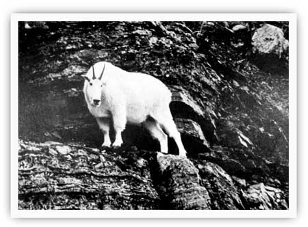
|
| The coastal littoral has long attracted a small corps of hunters on the lookout for mountain goats and black bear. Marilyn Warren photo, in Alaska Regional Profiles, Southcentral Region, July 1974, 147. |
In 1925, Seward witnessed a new form of recreational opportunity–aviation–that quickly put the previously inaccessible fjord and icecap country west of town within easy reach. That August, aviators Russell Merrill and Roy J. Davis flew from Anchorage down to Seward, and for the next several days the pair offered rides to all comers. The Alaska Road Commission, reacting to the growing popularity of aviation, roughed out an airfield in 1927-28, and in May 1928, Merrill and Davis "took three local passengers ... for a short flight over the bay and mountains." Aviation quickly caught on with Alaska's trappers, game guides and other outdoorsmen, but few tourists signed on, at least in Seward. [63]
Additional attempts to fly tourists took place during the 1930s, with mixed results. In 1932, Alaskan Airways began offering tourist flights from Seward to the Valley of Ten Thousand Smokes. In all likelihood, few responded to this offer. The following June a new pilot, Art Woodley, began offering a series of flights out of Seward. The news article announcing his flights spared few adjectives in describing the surrounding countryside:
Seward, the Kenai ice cap and the marvelous scenic wonders of Resurrection Bay from the air is the temptation Pilot Arthur Woodley will toss to local residents Sunday when he will be prepared to provide a series of airplane flights beginning early in the afternoon, weather permitting.
The flights will be made in the handsome six-seated, 300-horse power Bellanca plane.... The flights will be divided into two divisions for local air excursions. Ten dollars will be charged for a cruise over the great eternal ice cap of the rugged Kenai Peninsula, from which vantage point the marvels of hundreds of miles of scenic grandeur will be unfolded from Prince William Sound to Cook Inlet.
There will be the lesser flight out over Resurrection Bay, with the broad Pacific laving the rugged shoreline, another treat of thrilling scenic wonders. For this flight a fee of $5 will be charged....
Lastly, there will be the Russian River fishermen's cruise, down where the 30-inch Rainbow trout sport in the crystal pools and challenging the angler. For this cruise a fee of $15 will be charged for the round-trip.
These cruises should have a strong appeal to all who have never beheld Alaska's scenic wonderland from the ethereal heights, from which to look down upon a world shedding its chaste garments of winter for the verdure of spring, its mighty glaciers and Brobdingnagian pinnacles reaching upward to greet the air-minded. [64]
Despite the favorable publicity, Woodley was unable to fly that day, "pea-soup weather" being the culprit. A few days later, however, the weather cleared. [65] His operation that summer evidently had some success, because he offered a similar variety of flights the following year. Three years later, John Littley established Seward Airways, which evidently lasted only a short time; two years later, Seward Airways, Inc. commenced operation. Neither of these carriers appears to have advertised scenic or recreational flights as a primary aspect of their operation. [66]
Recreational Trends, 1940-1970
The Kenai National Moose Range is Established
On December 16, 1941, President Franklin D. Roosevelt signed Executive Order 8979, which established the Kenai National Moose Range. The range reserved much of the western side of the Kenai Peninsula in order to ensure the preservation of the local moose population.
The movement to create a game range on the western Kenai had been a long time in coming. Back in 1904, when forester William Langille made his initial venture into the area, he was quick to note that big game was an important peninsula resource; moose, caribou, sheep, and bear were all noted. Langille noted that
the game of the region should be a source of revenue to the people and of pleasure and sport to the outsiders who wish to hunt, and there should be some meeting place where the game can be conserved, clashing interests harmonized and trophy hunting permitted. [67]
Nothing came of Langille's recommendations, but they were not ignored. In 1916, forester Arthur Ringland, worried about game poaching by trophy hunters, repeated those recommendations. [68] But the U.S. Forest Service had little intrinsic interest in game protection, and the issue lay fallow for more than a decade. During this period, the number of homesteads grew in both the Kenai and Homer areas. Increasing settlement, along with increased market hunting, caused federal authorities to worry about the permanence of the peninsula's moose population. In 1931, therefore, the Alaska Game Commission recommended, at its regular annual meeting, that an 800,000-acre (1,230 square mile) moose sanctuary, to be located in the northwestern part of the peninsula, be established by presidential proclamation. [69]
That recommendation, although not acted upon, set off a long-running investigation into the size and health of the Kenai moose herd. The Game Commission, using donated funds, dispatched guide Henry Lucas into the Skilak-Tustumena lakes area in 1932. Lucas discovered, due to Game Commission enforcement efforts, that the moose population was no longer declining; he also noted that local residents were firmly in favor of a moose sanctuary being established. The Game Commission, after studying the matter during a second field season, backed the idea of a moose sanctuary in the Skilak-Tustumena lakes area; that area, however, promised to be controversial because it was a prime trophy hunting area. Before long, the federal Bureau of Biological Survey promoted a competing plan, for a 500,000-acre moose sanctuary in the northern part of the peninsula (that is, in the same general area that the AGC had recommended in 1931). By 1934, interagency differences on the proposal had still not been resolved; this impasse had the practical effect of shelving any protection proposals for the time being. [70]
In the late 1930s, new worries about a perceived decline in the peninsula's moose population sparked another round of studies. Biologist L. J. Palmer spent the 1938 field season in the Skilak-Tustumena lakes area. He confirmed a long-term moose decline, but instead of a moose sanctuary, he recommended that the area be set aside as a moose and mountain sheep reserve. The area would be open to limited hunting, but closed to homesteading or other land location without special permits. He returned to the field that winter, and came back convinced more than ever that a moose range needed to be established. [71] Palmer's research provided the technical data necessary to justify the moose range idea; two years later, Ira N. Gabrielson applied the idea politically and established the moose range. Gabrielson, a leading conservationist, was the head of the newly established U.S. Fish and Wildlife Service. It was he who guided the proposal–a far grander proposal than Palmer had ever envisioned–through the agency and on to Roosevelt's desk. [72]
The Kenai National Moose Range, as enacted, covered some 2,000,000 acres. As stated in the proclamation, the range was established
for the purpose of protecting the natural breeding and feeding range of the giant Kenai moose on the Kenai Peninsula, Alaska, which in this area presents a unique wildlife feature and an unusual opportunity for the study in its natural environment of the practical management of a big game species that has considerable economic value.... [73]
Although the range was primarily established to protect wildlife habitat, its southeastern boundary followed the top of the Kenai Mountains drainage divide and covered more than 100,000 acres of the Harding Icefield. Tens of thousands of these acres, located high in the Kenai Mountains, are now part of Kenai Fjords National Park.
By the time President Roosevelt signed the Kenai National Moose Range proclamation, Japan had bombed Pearl Harbor and World War II was at hand. Understandably, therefore, the range remained undeveloped for the next several years. It was not until 1948 that the first administrative facilities, at Kenai, were established. That September, David L. Spencer was appointed as the refuge's first manager; James D. Peterson was his assistant. [74]
Recreational Activities Along the Southern Coast
As has been noted (both in Chapter 9 and in a section above), commercial fishers and sightseeing parties were first lured to Resurrection Bay in the early years of the century and consistently used the resource in the decades that followed. The historical record is less forthcoming about Resurrection Bay sport fishing in the years prior to 1940. Most likely, sport fishing was a popular activity in and around Seward, and it may have also been part of early Resurrection Bay sightseeing activities.
After 1940 these trends continued. As Chapter 8 has noted, the military buildup prior to World War II brought thousands of soldiers to Seward's Fort Raymond and to the remote posts of Fort Bulkley (Rugged Island), Fort McGilvray (Caines Head), and similar installations scattered around Resurrection Bay. To cater to the soldiers' recreational needs, a variety of activities were organized. As early as April 1942, military authorities were sponsoring sightseeing and fishing excursions on Resurrection Bay. These seven-hour trips took place twice each week and appear to have continued, on a seasonal basis, through the summer of 1944. [75]
After the war, activity in Seward dropped off. But local officials, hoping to popularize the town, were buoyed by ongoing road development projects elsewhere on the peninsula and seized on those activities as opportunities to attract outsiders.
Several activities soon came to the fore. In 1950, before Seward gained its road link to Anchorage, local boosters began to advertise the traditional Mount Marathon race to out-of-towners. Five outsiders answered the call that year, and in 1951 a non-Seward resident won the race for the first time. During the mid-1950s, several nationally popular magazines noted the race in Alaskan feature articles. Over the years, the race attracted an increasing number of out-of-town contestants and their families. In recent years the Fourth of July race, and various associated events, have attracted thousands of participants and spectators each year. [76]
The road connecting Anchorage (and the rest of the Alaska road network) with the Kenai Peninsula was completed in October 1951. Soon afterward, residents from other communities began coming to Seward to fish and boat on Resurrection Bay. The number who engaged in such activities was at first fairly small. The migration was sufficiently large, however, to augment the fortunes of local businesses that sold licenses and gear, operated and coordinated charters, and processed fish. By 1953, sport fishing was sufficiently popular to attract the U.S. Fish and Wildlife Service; the agency dispatched an enforcement patrolman, Joseph Widauf, to Seward for the silver salmon season. Widauf reportedly "did a very good job acquainting the sportsmen with the regulations and keeping violations at a minimum." [77]
In 1956, Sewardites took a major new step when the town hosted its first Silver Salmon Derby. The event was the brainchild of local residents Jim and Celia Wellington. Juneau, by this time, had been holding its salmon derby for more than twenty years, and the Wellingtons, former Juneau residents, borrowed the idea and brought it to Seward. The derby, sponsored by the Chamber of Commerce, was held on two successive weekends in August; the proceeds of the event were used to stock local streams with game fish and to finance other local improvements. The contest quickly caught on with both locals and out-of-town residents, and by the mid-1960s, "large numbers of sports fishermen [were harvesting] a high proportion of the silver salmon entering Resurrection Bay." [78]
Pleasure boating also grew during the 1950s. Soon after highway from Anchorage was completed, locals formed the Seward Small Boat Owners' Association to improve the facilities in the small boat harbor. Then, in March 1957, the Anchorage-Seward Yacht Club was founded to promote nautical recreation and to push for harbor improvements. The organization, renamed the Alaska Yacht Club, was incorporated in January 1958. The club, which by the 1970s was known as the William H. Seward Yacht Club, is still active. Over the years, the club has held many sailboat races; during the late 1960s, one of the more challenging races was the Summer Solstice meet, a 70-mile race that took contestants from Seward to the Chiswell Islands and back. [79]
With few exceptions (such as the boat races just noted), most of the boating and sportfishing activity that took place out of Seward from the 1940s through the 1960s was limited to Resurrection Bay. Very few boated or fished for pleasure in park waters. Known instances of such use are described below.
During World War II, the USO-SSO Activities Council (which organized recreational activities for soldiers) sponsored a series of boat trip outings, at least one of which entered park waters. In August 1944, it organized a free daylong trip to Aialik Glacier. Trips to other nearby features–Bear Glacier or the Chiswell Islands–may also have been sponsored during the war years. [80]
During the 1950s, the Fish and Wildlife Service wrote a special report on the Kenai Peninsula's fishery resources. The report noted that none of the bays or rivers in the present park ranked particularly high among the peninsula's sport fishing destinations. It did, however, state that in 1955, Resurrection River recorded 1,000 man-days of use by sport fishers, a volume that was exceeded by eleven other peninsula sport-fishing areas. [81]
In July 1961, the Bureau of Land Management classified hundreds of Alaska public land parcels as recreation and public purpose sites. These parcels, scattered throughout the state, were authorized by a Congressional act of June 14, 1926 and were available for disposal to "a state, territory ... or to a non-profit corporation or nonprofit association for any recreational or any public purpose." Within the present park boundaries, two parcels were classified by the BLM's action: a 900-acre parcel in the Bulldog Cove area, south of Bear Glacier, and an 80-acre parcel on the east side of Aialik Bay, just south of Coleman Bay. Available land records do not specify who may have been interested in the parcels, nor do they describe the parcels' intended land use. Lacking other evidence, it appears that the BLM probably offered the parcels to the State of Alaska. They were offered either to the Division of Lands for a future state park or recreation site or (less likely) to the Department of Fish and Game for fish management purposes. The interested party–whoever it was–soon learned that part of the Bulldog Cove parcel had previously been claimed by Raymond W. Gregory, who hoped to establish a fishing lodge on the property. Gregory, as it turned out, never developed his lodge plans, but the existence of his claim probably prevented the state from developing the site. Neither parcel was developed, and in January 1969 the two parcels were returned to the public domain. [82]
Sidney Logan, an ADF&G fisheries biologist, was posted in Seward in April 1961, largely due to the efforts of Seward Salmon Derby officials. In a recent interview, Logan recalled that Seward had four or five boats available for charter during the seven-year period he lived there; sportsmen normally did not fish farther south than Rugged Island, although they occasionally fished as far south as the Chiswell Islands. He noted that "hundreds of boats per summer visited the Kenai Fjords coast" during the years he lived in Seward. Logan was quick to point out, however, that "there was no sport fishing activity to speak of" in the fjords and that the amount of fishing was "insignificant" in comparison to either the Resurrection Bay silver salmon sport fishery or the Russian River sport fishery. Fishers sought out the waters of the future park for halibut, rockfish, and lingcod; so far as he recalled, no charter-boat operators consistently referred clients to locations in park waters. He did not recall any problems managing the park's sport fishery during this period. As to sightseers, Logan had no recollection of any; "there may have been some," he noted, "but I wasn't aware of it." [83]
Jim Rearden, who served as the Homer-based commercial fisheries biologist for ADF&G from 1960 to 1969, recalls that the waters of the future park supported much less activity than Logan had estimated. Rearden, who flew along the coast several times each year, stated in a recent interview that there were "virtually no sports fishermen" in the fjord waters during his tenure in that position. He recalled that the Seward boat harbor had "almost no sports boats before the [1964] quake" and that the waters in the fjords were too rough to allow sport fishing with the boats then available. [84]
Research by historian Mary Barry largely corroborates Logan's and Rearden's recollections. Barry noted that before 1960, Mark Walker's Breezin' Along was the only large boat in Seward available for fishing charters. (Several smaller boats also carried small numbers of paying fishermen.) During the early 1960s, there were approximately six charter boats; Jim Lawson and his wife started the Fish House during this period to coordinate fishermen and charter boats. The fishing fleet was largely wiped out in the 1964 earthquake, but a year later several charter boats were again available, the largest being the 83-foot Maxine, which carried 49 passengers. In 1968, a new company organizing fishing charters–Resurrection Bay Tours–commenced operations. Don Oldow, a veteran ship pilot, founded the company with his wife Pam. Beginning in 1974, the company began serving the fjord country. It thus played a key role in stimulating tourism to the fjord country, and it also assisted the NPS in its investigations of the proposed park unit. [85]
Ted McHenry, who moved to Seward as a sport fisheries biologist in 1969, recalls that there were "an odd few"–perhaps 20 boats per summer–that went into park waters during his first year or two of residence. Those few were operated primarily by Anchorage people who had "larger boats" moored at the Seward boat harbor. Most of those who sailed into park waters headed for Aialik Bay; others went to Harris Bay. McHenry felt that the boat owners, some of whom were veteran Resurrection Bay sports fishers, were attracted to park waters because they offered better opportunities to harvest halibut, salmon, rockfish, red snapper, black bass, and lingcod. [86]
If fishing and sightseeing were occasional activities in the future park during the 1940s, 1950s, and 1960s, hunting appears to have been an even rarer activity. Little solid evidence has come to light regarding how much hunting has taken place. Prior to the mid-1960s, few sport hunters were willing to brave the fjord country's rough waters. Hunting pressure was slight for several reasons: the number of large mammals was relatively small, species such as Dall sheep and moose were unavailable, and the megafauna that inhabited the area–black bear and goats–could be harvested with less effort elsewhere. The only hunter known to frequent the outer coastal area during this period was Martin L. Goreson. Whether he hunted in the park is a matter open to debate.
Goreson, who hailed from New York, was one of hundreds of GI's who landed in Seward and served at Fort Raymond. After the war ended, he remained in town as a guard at the mothballed camp until October 1947, when the camp passed into private hands. Goreson then went into the guiding business, and in 1950 he heard about a Fish and Wildlife Service plan to transport goats from the Seward area to Kodiak Island. For two years, agency staff tried and failed to capture any goats; Goreson then stepped forward and volunteered. To the surprise of agency officials, Goreson was able to collect at least five mountain goats, more than enough to successfully initiate a Kodiak Island goat herd. [87] Several local wildlife experts have suggested that Goreson captured at least some of these goats within the boundaries of the present park. Available research, however, suggests that most if not all of his goat gathering took place either on the slopes of Mount Alice (northeast of Seward), near Day Harbor (east of Resurrection Bay), or at South Beach (near Caines Head). [88]
When a national park was being considered for the area in the early 1970s, the state (which favored the status quo) and the National Park Service (which backed a plan that would prohibit hunting) had widely divergent opinions on historical hunting levels. The state, citing the existence of an airstrip (built in 1965) at the head of Beauty Bay, noted that "the lands surrounding Beauty Bay have had a long history of seasonal use by hunters and fishermen because of ... its proximity to Homer." But NPS officials disputed that assertion and countered that "access [to the proposed park] for hunting is limited by the rugged terrain, weather conditions and general accessibility;" for that reason, "relatively few people would be affected" if a park was established. The agency noted that "the wild coastline and the lack of interest generally has kept sport hunting down. Harvest ticket counts ... show relatively low use." Citing ADF&G records for 1973, for example, the NPS noted that nine goat hunters had canvassed the coastline that year and bagged four goats. The NPS further noted that "only one full-time guide out of Seward hunts the fjord coast for mountain goat and black bear, the only two big game species represented in the proposal," and it was quick to point out that most of the guide's income was from non-hunting sources. [89]
In the Resurrection River valley, the NPS recognized that hunting opportunities were more favorable. A government report stated that "hunting of mountain goats also occurs [in the valley], where a few moose may also be taken." The state, however, closed the area along the newly constructed Exit Glacier Road in the early 1970s, probably to enhance wildlife viewing opportunities for tourists (see section below). It reportedly did so "at the request of the Seward Community who wished to encourage the viewing of unhunted wildlife in their natural habitats." [90]
Throughout the quarter-century that followed World War II, Seward itself was a relatively minor tourist draw. As noted above, the completion of the road to Anchorage made Seward accessible to rubber-tire travelers, and out-of-towners to an increasing degree flocked to Seward for the Fourth of July (for the Mount Marathon race and associated activities) and in August (for the Silver Salmon Derby). Except for those two events, however, the town had few tourist attractions. Seward promoters trumpeted that its Fourth Avenue had "the second brightest street in America" (only Chicago's State Street was brighter), and in the mid-1960s the town proclaimed itself the "Fun Capital of Alaska." Those claims, however, did little to change the town's overall perception; as a 1975 article noted, "When you mention Seward, most Alaskans think of a sleepy little town at the end of the highway." [91]
Oil Exploration and Kenai National Moose Range Management
One of the most significant events in Kenai Peninsula's history was the discovery of oil along the Swanson River, northeast of Kenai, in the summer of 1957. Because of the widespread period of oil exploration that preceded the find–and particularly because of the rush of activity that followed it–thousands of people descended on the Kenai, and thousands of acres of wilderness were converted to residential, commercial, and industrial purposes. Paradoxically, however, the only effect that this activity had on land in or near the present park was a blanket prohibition on oil and gas development. The following paragraphs explain how these developments were manifested.
As noted above, President Roosevelt had signed an executive order establishing the Kenai National Moose Range in December 1941. The range had remained intact and generally undisturbed during the war years; shortly after the cessation of hostilities, however, three privately-owned townships in the present Soldotna and Sterling areas were homesteaded and subsequently eliminated from the range. In 1947, a fire started by road workers destroyed 400,000 acres of wildlife and wildfowl habitat on the 2,000,000-acre range; on the heels of that fire, the U.S. Fish and Wildlife Service set up a headquarters for the range (in Kenai) and dispatched two men there to staff it. [92]
Before long, oil company representatives began to eye the range, and in 1952 seismic exploration began. Exploration, most or all of it taking place north of the Sterling Highway, continued at an increasingly hectic pace for the next several years, in large part because of the pro-development policies of Interior Secretary Douglas McKay. The frantic level of activity slowed in June 1956 when Fred Seaton succeeded McKay; Seaton halted any new oil and gas exploration until impact studies could be completed. But the pressure for development skyrocketed on July 23, 1957, when the Richfield Oil Company announced that one of its wildcat wells had struck a significant oil deposit more than two miles underneath a Swanson River moose pasture. [93]

|
| Map 10-3. Kenai Moose Range Boundaries, 1941-1971. (click on image for an enlargement in a new window) |
The Interior Department was soon inundated with requests that would have opened most of the Kenai Moose Range to oil-development activity. Congress reacted to the pressure by holding hearings in Washington because it wanted to know how the agency could simultaneously protect wildlife and permit petroleum development. Those hearings took place in December 1957. In the face of such development pressure, all the agency could realistically hope to do was shield a reasonable portion of the area from petroleum development. Secretary Seaton, therefore, decided in late January 1958 to close approximately half of the range to oil and gas leasing "because such activities would be incompatible with the management thereof for wildlife purposes." [94] Seaton, however, did not issue a Secretarial Order with that language until July 24 (see Map 10-3). The order declared that most of the range's southern half–including all of the land in the high-elevation country overlooking Skilak and Tustumena lakes–would be off-limits to oil and gas leasing. [95]
Pro-development forces, both inside and outside of government, demanded that Seaton open up more of the moose range to oil development. The agency, worried about a sharp drop in the area moose population, initially refused to budge. Eventually, however, the Bureau of Sport Fisheries and Wildlife (part of the Fish and Wildlife Service) agreed on a land swap with the Bureau of Land Management and the Alaska Division of Lands. The various agencies agreed that the boundary realignment was "necessary in order to facilitate administration of the Range and as a basis for the survey of adjoining selections by the State of Alaska." The land trade entailed the removal of 310,000 acres of existing refuge land–most of which lay on the Harding Ice Cap and thus had low wildlife values–and added 40,115 acres of land in the Caribou Hills, adjacent to the refuge. On May 22, 1964, Interior Secretary Stewart Udall signed a Public Land Order that codified the land swap. The 270,000-acre reduction was not enough for the Alaska Congressional delegation, which attempted to eliminate another 270,000 acres. (Senator Ernest Gruening, part of the delegation, went so far as to urge that the entire moose range be returned to the public domain.) That move, however, was squelched, and the boundaries that were established in 1964 remained until the passage of the Alaska National Interest Lands Conservation Act in December 1980. [96]
The agency's early plans for the refuge (and in particular its plans for the Kenai Mountains portion of the refuge, adjacent to the present national park) were by necessity inseparable from the ongoing, petroleum-dominated political atmosphere. Agency officials nevertheless recognized that the range's ecological diversity demanded two different management objectives. Biologist Will Troyer, who wrote an early management document for the Bureau of Sport Fisheries and Wildlife (BSF&W), stated that the refuge had been created to "support large populations of moose, as well as quality trophy animals." The lowlands, he noted, were managed for high moose populations. The range also, however, had more than 500,000 acres of "spectacular mountain country" that the agency planned to manage for "trophy purposes and high quality hunting enjoyment." He recognized that nearly all hunting in the refuge took place in the lowlands. The managing agency, however, was also "obligated to manage a portion of this area for trophy animals," particularly of Dall sheep. [97] Because most hunting pressure took place in the lowlands, the agency had a largely laissez faire attitude toward the higher elevation areas of the refuge; so far as is known, it conducted no research projects in the highlands portion of the moose range.
During the 1960s and on into the 1970s, the BSF&W's management attitude toward the southeastern portion of the moose range remained consistently protective. In February 1960, for example, the agency released a recreational management plan for the refuge. The plan stated that "a management approach forcefully directed at a wilderness concept is required to preserve a resemblance [sic] of natural conditions caused by the inevitable forces of progress." The plan proposed numerous recreational improvements for the refuge, but none in the southeastern uplands. [98] In April 1971, the Fish and Wildlife Service released a wilderness plan for the refuge; it proposed more than a million acres of wilderness, including a huge Andy Simons Wilderness Unit encompassing all of the refuge's high country. (Simons, at noted above, was a famous, long-time guide who had died just a few years earlier.) [99] That plan was not implemented. Most of the acreage in the Andy Simons Wilderness proposal, however, became congressionally designated wilderness nine years later with the passage of ANILCA.
The Exit Glacier Road
As noted in Chapter 5, Seward citizens had been lobbying off and on since the 1920s for a road that would connect Seward to the Cooper Landing area via the Resurrection and Russian River valleys. Neither Federal nor state funding authorities had ever seriously considered these proposals. The completion of the Sterling Highway, and the connection of the Kenai Peninsula road network to Anchorage, largely negated the need to build such a road. But road-based tourism, which consistently increased during the 1950s and early 1960s, spotlighted the need to develop new area attractions, and the devastation wrought by the 1964 earthquake underscored the critical need to diversify Seward's economy. Herman Leirer, whose family had operated the local dairy since the mid-1920s, was acutely aware that far too many people "drove down the highway into town, then turned around and headed back because there wasn't anything to do." [100]
Leirer, Jack Werner, and other residents felt that "Resurrection Glacier," eight miles northwest of town, would be an excellent new sightseeing destination. In order to access the glacier, they decided to build a road there. By October 1965, they had convinced Seward City Manager Fred Waltz and the city council to take up the cause; they, in turn, organized a committee to complete the seven-mile access road. Many Seward residents, including some of the trainees at the local Skill Center, immediately set to work; the city helped by loaning them graders, loaders, and other equipment. Work continued until cold weather forced a cessation of activity. The following year, work was furthered by a grant from the Alaska Purchase Centennial Commission; efforts continued throughout the warmer months, primarily on weekends. [101]
Work continued at a slower pace until 1970. By that time, four miles of road had been roughed out and the state had expended $58,000. In July 1970, Governor Keith Miller announced that the state would provide an additional $125,000 for road construction; this was intended to be sufficient to complete the road. By the end of the 1971 construction season, a gravel road that was "generally too rough for many passenger cars" had been largely completed from Seward Highway to the east bank of the Resurrection River. West of the river, a 1.75-mile road was bladed out in 1970 between the river and a site 0.2 miles east of Exit Glacier. All that was needed to complete the 9.3-mile road between Seward Highway and the glacier was the construction of two bridges, one of them over the Resurrection River. [102] A decade, however, would pass by before a pedestrian bridge was constructed, and another five years would elapse before vehicle access to the Exit Glacier area was a reality. [103]
Few tourists traveled the rough, unpaved road during the 1960s or 1970s. One user group, however, was the U.S. military. Since 1950, Seward had been home to an Army Recreation Center; the center's primary purpose was to provide deep sea fishing opportunities for troops from Whittier and Fort Richardson. But in 1970, the recreation center–and the Exit Glacier road–became part of rigorous outdoor training program. Twice a week, fifty-man platoons from Fort Richardson were dropped off at the Kenai River-Russian River confluence; from there, they hiked up the trail to Upper Russian Lake, then bushwhacked over the drainage divide and down the Resurrection River valley to the road terminus near Exit Glacier. The four-day hike gave the soldiers practice in survival, patrolling, camouflage, land navigation, and communications. It is unknown whether the military conducted these hikes in other years. [104] The Resurrection River valley remained isolated until the 1980s, when crews under contract to the U.S. Forest Service completed a 16-mile trail that connected the Exit Glacier road with the Russian Lakes trail. [105]
Mountaineers Explore the Harding Icefield
As noted above, Seward residents generally ignored the huge icefield west of town before 1922. The construction of the Spruce Creek trail that year, however, made it possible to view the upper portions of the icecap, and President Harding's promise to visit the territory was sufficient to bestow his name on the feature. Between the mid-1920s and the early 1930s, the increasing popularity of aviation had given a lucky few the opportunity to soar over the icefield. Up to this point, however, people had walked only on the icefield's margins. [106]
In early 1936, a 27-year-old Swiss immigrant named Yule Kilcher disembarked in Seward. He was headed for Kachemak Bay, where he intended to take up residence, but he was so intrigued by the icefield he had seen from the steamship that he vowed to cross it before long. Unwilling to wait two weeks for a coastal steamer, Kilcher walked to the Homer area, probably by way of the Resurrection River valley. After securing a homestead, he returned to Seward, and in late July he hiked up the Lowell Creek drainage toward the icefield. Conditions on the icefield overwhelmed him, however, and a week later he was back in Seward. [107]
About 1940, two Kenai Peninsula residents, Eugene "Coho" Smith and Don Rising, apparently were successful in their attempt to cross the icefield. They hiked from Bear Glacier west to Tustumena Glacier. The men, however, told no one of their intentions, and once they returned, Smith's wife was the only one that was aware of what they had done. Their trip remained a virtual secret for more than twenty years after they completed it. [108]
Two parties attempted to cross the icefield in the mid-1960s. In 1963, a party consisting of Don Stockard, Tom Johnson, and Carl Blomgren tried a westbound crossing. Three years later, J. Vin Hoeman, Dave Johnston, and Dr. Grace Jansen made an eastbound attempt. Both attempts were unsuccessful. [109]
In the spring of 1968, the first documented mountaineering party succeeded in crossing the icefield. Ten people were involved in the crossing, which went from Chernof Glacier east to Exit Glacier. Expedition members included Bill Babcock, Eric Barnes, Bill Fox, Dave Johnston, Yule Kilcher and his son Otto, Dave Spencer, Helmut Tschaffert, and Vin and Grace (Jansen) Hoeman. As noted above, Yule Kilcher, Dave Johnston, Vin Hoeman, and Grace Hoeman were veterans of previous attempts; of the ten, only four–Bill Babcock, Dave Johnston, Yule Kilcher, and Vin Hoeman–hiked all the way across the icefield. The expedition left Homer on April 17, bound for Chernof Glacier; eight days later, they descended Exit Glacier and arrived in Seward. Along the way, the party made a first-ever ascent of Truuli Peak, a 6,612—foot eminence that protrudes from the northwestern edge of the icefield near Truuli Glacier. [110]
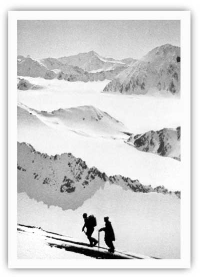
|
| Eric Barnes and Helmut Tschaffert during their ascent of Truuli Peak in April 1968. David Spencer photo, Alaska Magazine, May 1971, 47. |
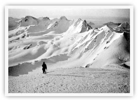
|
| Bill Babcock looks out from a nunatak on the morning of April 25, 1968. Dave Spencer photo, Alaska Magazine, May 1971, 46. |
After the 1968 success, the icefield was crossed with increasing frequency. The Seward newspaper reported that two parties crossed during the summer of 1970, and during the early 1980s an NPS report stated that "1 to 2 Harding Icefield expeditions per year have taken place over the last five years." Most of those traverses began at Exit Glacier and ended in Homer. [111]
The Harding Ice Field Snowmobile Development
During the 1960s, when mountaineers were showing an increasing amount of interest in crossing the Harding Icefield, local entrepreneurs were beginning to envision the commercial possibilities of taking tourists up to the icefield on short-term excursions.
Commercial interest in the icefield apparently began in the spring of 1966 when Seward resident William C. Vincent made his first visit. Vincent, who ran a plumbing and heating shop, had lived in Seward since 1950; he was a Chamber of Commerce member and a two-term city councilman. [112] Vincent quickly became enthusiastic about the icefield; by January 1967, he had assembled a four-person development team and publicized a five-year icefield development scenario. As his granddaughter later noted, the team "proposed to make the Harding Icefield a visitors resort with glacier skiing, snowmobile tours, summer ski racing camps, mountaineering, outward bound camps, and cross-country ski touring." The first development project would be the construction of a small dock at Bear Glacier. [113]
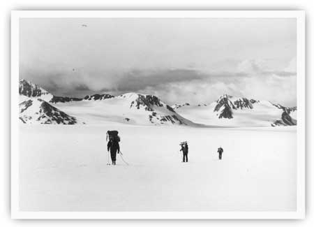
|
| A trio of skiers crossing the Harding Icefield during the 1970s. M. Woodbridge Williams photo, NPS/Alaska Area Office print file, NARA Anchorage. |
Vincent's development project was never realized, but others shared his dreams and decided to act. Jim Arness, who operated a snowmachine rental shop in North Kenai, "dreamed up" the idea of establishing a snowmobile touring operation on the icefield near Seward. He therefore teamed up with Joe Stanton, the head of Harbor Air Service, and in the summer of 1969 the two constructed a "shack" on the icefield–reportedly "somewhere near the headwaters of Exit Glacier"–and brought three ski-doos up to the site. The operation that year apparently lasted for only a short time; snows that autumn came so quickly that both their building and one snowmachine were buried before they could be removed. The items were never recovered. [114]
Undaunted, the pair returned the following spring and began constructing a 16' x 20' equipment shed and warming hut. Soon afterward, they flew ten ski-doos (nine single-tracks and one double-track) and three ski-boos (sleds) up to the icefield. [115] In May, amid much fanfare, local residents and tourists began flocking to the site; some came to ride the snowmachines, but others wanted to ski, snowshoe, or merely sightsee. By early June, approximately 100 people had been flown up to the icefield, and by late July an estimated 200 to 300 had made the trip. To judge by contemporary accounts, reaction to the operation was overwhelmingly positive; local resident Dot Bardarson noted that her flight and snowmachine ride was "the best $70 I ever spent." The project's backers, sensing that it would be a long-term success, laid plans to increase the size of their operation. They envisioned a $1.5 million construction project that would include a gondola lift system (to take people to the top of Exit Glacier), a summit station, a lower terminal, and a T-bar lift near the warming hut. [116]
But in early July 1970, the operation hit a major snag when Bureau of Land Management officials in Anchorage read newspaper accounts about it. They quickly learned that the operation was being held on BLM land–and thus needed an agency-issued Special Land Use Permit–but Arness, the operation's organizer, had not applied for one. Making the situation far murkier was Interior Secretary Stewart Udall's 1966 land freeze order. This action withdrew the Harding Icefield (along with most of Alaska's unreserved public land) from entry; as a result, Arness would not have been approved for a permit even had he applied for one. BLM official Sherman Berg drove to Kenai on July 9 and discussed the matter with Arness; Berg personally expressed hope that a satisfactory resolution could be worked out, but he could promise nothing. Meanwhile, the agency handed Arness a tresspass injunction. He was given thirty days to quit his operation and vacate the area. [117]
Seward area residents, predictably, were saddened by the BLM's decision. The Seward Phoenix Log, in an editorial, said "Let us hope that something can be done to see that the Cap development continues–it means a lot to Seward and the rest of the Kenai Peninsula." H. A. "Red" Boucher, who was running for governor at the time, visited the icefield on July 20; he vowed to keep it open and wrote a lengthy letter to BLM officials protesting the planned expulsion. [118]
The actions of Boucher, Arness, and local officials gave the operators a little breathing room; the operation's deadline to vacate was extended from August to November. But on the larger question, the BLM could not budge, perhaps because of the precedent that such an action would have had on other Alaska public lands. Given that scenario, the operation continued in business until September 1970, perhaps later. The operators, however, were forced to leave so quickly (perhaps because of a heavy, late-season snowstorm) that, as in 1969, they left their warming hut in place where it was engulfed by the winter's snowfall. As for the snowmobiles, several more were lost. One account states that two were buried near the warming hut, while another avers that the operators attempted to drive three off the icefield but became stuck in the crevasses of Bear Glacier. [119]
Bill Vincent, who fully supported the Arness-Stanton operation, refused to give up. He recognized that the icefield was an attraction that "would offer something strangely unique to visitors regardless of where they may have come from." Comparing the area to Columbia Icefield in Canada's Jasper National Park, he furthermore noted that the icefield could be put to any number of uses, including "a military testing area for arctic equipment and survival and an international type hotel." As late as February 1971, he wrote that his group "still plan[s] on seeking private capital to develop the field." [120] The continuing land freeze and the long battle over Alaska's national interest lands, however, prevented any such plans from being implemented, at least in the short term.
One positive spinoff of Vincent's publicity and the Arness-Stanton operation was a revival of interest in Seward-based tourist flights over the icefield. As noted above, flights over the icefield had been advertised, primarily to Seward residents, for short-term periods in both the 1920s and 1930s. In the decades that followed, some tourists doubtless arranged for overflights with Seward- or Homer-based pilots. But no one, so far as is known, advertised such a service. Beginning in 1970, however, the Milepost–a well-known tourist publication–began to advertise the beauty of the Harding Ice Cap in its Seward section and also urged tourists to see the Ice Cap "via charter plane trips." This verbiage, often accompanied by advertisements from local air taxis, remained in future Milepost issues as well as in other local promotional literature. [121]
Federal Efforts to Preserve the Icefield and
Fjords, 1968-1980
The National Natural Landmark Nomination
Prior to the late 1960s, federal and state authorities had paid little attention to the coastal fjord country. Early efforts, as noted in previous chapters, had been limited to U.S. Coast and Geodetic Survey investigations in the 1904-06 period, a U.S. Geological Survey visit in 1909, and occasional visits by USGS and Bureau of Mines personnel in the 1920s and 1930s. The military showed a brief interest in the area during the early 1940s; then, a decade later, the Fish and Wildlife Service began stationing personnel at various area sites. The newly established Alaska Department of Fish and Game continued this practice for a year or two; for the remainder of the decade, however, their presence was limited to aerial flights related to fish management activities. The Fish and Wildlife Service, according to a former agency official, also tried to do waterfowl surveys along the southern Kenai coastline "sometime during the 1960s" as part of a broad study on wintering waterfowl along the Alaska coast. Due to poor weather, however, the agency "didn't get much good data" from the Kenai coast. In 1956, the territorial ADF&G had conducted a sheep survey at nearby Cooper Mountain and in the mountains surrounding Crescent Lake; the agency did not conduct surveys within the boundaries of the present park, however, until goat inventories were conducted in 1968 and 1969. [122]
The late 1960s brought a new governmental study of the area. The National Park Service, which had previously shown no interest in the southern Kenai coast, contracted with an Anchorage college to evaluate the Harding and Sargent Icefields for the National Natural Landmarks (NNL) program.
The NNL program was fairly new, the NPS having launched it in 1962. The agency established the program in order to recognize and encourage the preservation of significant natural lands. The NNL program was akin to the National Historic Landmarks program, which had been established two years earlier; the agency created both programs, in part, because of the increasing difficulty of adding new units to the NPS system. On March 17, 1964, Interior Secretary Stewart L. Udall announced the inclusion of the first seven areas in the new NNL system. None were in Alaska. [123]
In the spring of 1967, the agency began to turn its attention to the forty-ninth state. That April, Lake George–a site near Anchorage that was well known for its annual outburst floods–was declared the first Alaska NNL. A month later, NPS Assistant Director Theodor Swem allotted $20,000 for studies of potential natural landmarks. As a result of that and subsequent allotments, approximately fifty Alaska features had been evaluated for the program by the end of 1969. Investigators stated that more than forty of those sites were qualified to be National Natural Landmarks. Only fifteen of those sites, however, were named as NNLs. [124]
In May 1968, officials in NPS's Alaska Field Office moved to have the Harding and Sargent Icefields evaluated as a National Natural Landmark. Several factors apparently moved the NPS to take this action. First, NPS planner Craig Breedlove–one of the few employees in the agency's Anchorage office at that time–had flown over the icefields in the spring of 1967 and had been impressed by their beauty and expanse. Second, a mountaineering party had just completed a well-publicized traverse of the Harding Icefield. Third, the huge size and uniqueness of the icefields demanded their inclusion on an inventory of this type; as the report evaluating the icefields noted, "The uniqueness of these areas was deemed worthy of investigation for a natural landmark site." [125]
On May 21, NPS officials tendered a contract with Anchorage Community College, and paleontologist Ruth A. M. Schmidt agreed to evaluate the icefields' NNL eligibility. Dr. Schmidt first discussed the icefields with Dr. Troy Péwé, a geologist at the University of Arizona and with H. R. Schmoll of the U.S. Geological Survey. Then, on July 24, she flew over the icefields. The following January 20, she submitted a report to the NPS stating that the Harding and Sargent icefields were two of only three relict glacial icefields located wholly within the United States. (Bagley Icefield, east of Cordova, was the third.) They furthermore represented "vanishing geological phenomena." She noted that there seemed "little possibility that man will endanger the integrity of either of these ice fields." She cautioned, however, that "at the present time, they are reasonably free of man-caused influences, and as such, are rare examples of our country's natural heritage." She thus found them outstanding on several counts, and concluded that "the Harding and Sargent Ice Fields are eligible for inclusion in the National Registry for Natural Landmarks." [126]
George Hall, who headed the NPS's Alaska Field Office, forwarded Schmidt's recommendations on to the Washington office. In a May 27, 1969 letter, Hall told Assistant Director Theodor Swem that the recently-completed evaluation of the two icefields "indicates that they are rare examples of our country's national heritage.... We recommend that [they] be strongly considered for eligibility under the Natural Landmarks program." [127] Despite Hall's urging and Schmidt's ringing endorsement, however, the nomination was not forwarded through either the NPS's Washington office or the Interior Secretary's office, and the site was not declared eligible for the NNL list. The Joint Federal-State Land Use Planning Commission, an interagency group studying Alaska lands issues, stated in the early 1970s that the icefields had "ecological reserve potential," but the icefields never attained either NNL or ecological reserve status. [128]
The Seward National Recreation Area Proposal
As noted above, the U.S. Fish and Wildlife Service made several moves, on the heels of the Kenai Peninsula oil-exploration frenzy, to protect portions of the Kenai National Moose Range. In 1958, it had declared about half of the range–including all of its land in the Kenai Mountains–off-limits to oil exploration. Six years later, a Secretarial Order had modified the range's boundaries to eliminate much of its ice-cap acreage. In order to protect its remaining high-elevation acreage, however, the agency submitted a proposal in April 1971 that would have put more than a million acres of the range in the National Wilderness Preservation System.
Just a month before the Fish and Wildlife Service submitted its wilderness proposal for the Kenai National Moose Range, Alaska's congressional delegation began making its own proposals for the huge amount of Forest Service and BLM land located elsewhere on the peninsula. On March 24, 1971, Senator Ted Stevens submitted Senate Bill 1356, which would have established a 1,400,000-acre Seward National Recreation Area, to be administered by the Secretary of Agriculture. The proposed NRA stretched from Crow Pass (near Girdwood) all the way south to Godwin Glacier (east of Seward); west of Seward, it also included Exit Glacier, Lowell Glacier, and more than 50,000 acres of the Harding Ice Cap. In commenting on the bill, Stevens remarked that the NRA would be managed "for public outdoor recreation benefits and the conservation of biotic, scenic, scientific, geologic, historic and other values." But the bill, which was patterned after legislation that established other National Forest recreation areas, allowed a broad mix of land uses, including timber-cutting, mining, sport hunting, and other forms of recreational use. Most of the land involved in the proposal was U.S. Forest Service land, but some 116,000 acres (including the ice cap acreage) was on BLM land. (Within two years, as noted below, the NPS would be formulating its own proposals for the BLM portion of the Seward NRA proposal.) [129]
Inasmuch as the bill creating the Seward NRA largely perpetuated the status quo, local residents appear to have favorably viewed S. 1356. Before long, Alaska's sole House member, Nick Begich, submitted a similar bill in that body. The BLM, which had a multiple-use philosophy similar to that of the Forest Service, also favored the bill; in its 1971 report on the legislation, the agency proposed extending Seward NRA's proposed boundaries south to the coast to include Aialik and Harris bays. As is noted in a section below, proposals for a Seward NRA remained active for the remainder of the decade, though it soon became one of many competing proposals regarding Kenai Peninsula's (and Alaska's) public lands. [130]
Proposed Interior Department Reservations
In December 1971 the fate of the Seward NRA proposal, and the status of public lands throughout Alaska, was cast in an entirely new mold when Congress passed, and President Nixon signed, the Alaska Native Claims Settlement Act (ANCSA). The bill's primary aim was to provide a land settlement, and cash payments, to Alaska's Native peoples. But one small provision inserted into the bill–Section 17(d)(2)–set the stage for a public debate that would dominate Alaska for the remainder of the 1970s. This provision demanded that Congress, within a seven-year time frame, determine the fate of Alaska's federal public lands by including them in one of several protective classifications. [131]
The general outline of the Alaska public lands debate, which culminated in the December 1980 passage of the Alaska National Interest Lands Conservation Act, is fairly well known. Historian Frank Williss has written a comprehensive account of this process from the National Park Service's point of view. The present study will present only a general outline of how the Kenai Fjords National Park proposal developed; a more detailed account is within the purview of an administrative history.
When ANCSA was passed in December 1971, both the NPS and the U.S. Fish and Wildlife Service had already shown an interest in the area. The F&WS had been managing a large part of the Kenai Peninsula for more than thirty years, and it had previously exhibited some research interest in the southern coast. The NPS, for its part, had had several exposures with the area. NPS planner Craig Breedlove, as previously noted, had flown over Harding Icefield five years earlier. In 1968-69, the agency contracted with the University of Alaska regarding the Harding and Sargent Icefields NNL nomination. During the summer of 1970, Breedlove and NPS planner Richard Stenmark made an overflight of the southern coastline in order to gather information for Interior Secretary Walter Hickel's Alaska Parks and Monuments Advisory Committee. Perhaps the most significant event had taken place during the summer of 1971, when NPS Director George Hartzog accompanied Senator Alan Bible (D-NV) on a visit to the southern Kenai coast. Perhaps as a result of the Hartzog-Bible visit, Director Hartzog outlined the so-called Kenai Fjords [132] area as one of several proposed parks and monuments in a November 1971 memorandum. Theodor Swem, who as the NPS's Assistant Director for Cooperative Activities was Hartzog's right-hand man on this issue, recognized that the NPS knew little about the area outside of what had been written in the Harding Icefield report. Swem, recalling that period, stated that "We probably thought that the Icefield wouldn't qualify on its own, so we asked about surrounding values as well. Probably Dick Stenmark or someone else had the answer, and told us they deserved consideration." [133]
In the wake of ANCSA's passage, NPS officials recognized that the agency would be competing with other federal agencies for the right to manage the hundreds of millions of acres of Alaska national interest lands. The NPS, therefore, quickly began to prioritize its interests. By early January 1972, planner Richard Stenmark had assembled the agency's first rough list of proposed park areas, and on March 9–in accordance with an ANCSA-imposed timetable–Interior Secretary Rogers C. B. Morton made a preliminary withdrawal of approximately 80 million acres of so-called "d-2" land. Some 33.4 million of those acres had been withdrawn at the NPS's request. [134]
During the three-month period that followed the passage of ANCSA, the NPS showed a schizophrenic attitude toward the Kenai Peninsula's southern coast. In one January 1972 list of proposed parks, for example, Stenmark included the area, but another such list that month overlooked it. As the winter wore on, according to Williss, the area remained a more consistent priority in the minds of NPS officials. But by this time, Natives within the newly formed Chugach Alaska Corporation had made it known that they planned to claim much of the fjord country, using the "deficiency lands" clause, as part of their ANCSA allotments. Those claims threatened to prevent the NPS (or any other federal agency) from assembling a cohesive management unit. In order to meet the 80 million acre limit, therefore, the NPS deleted the Kenai Fjords area from its March 1972 list and allowed the Bureau of Sport Fisheries and Wildlife (part of the U.S. Fish and Wildlife Service) to claim the area as part of its Aialik withdrawal area. Morton withdrew some 139,600 acres along the Kenai Peninsula's southern coast, much of which is now included in the present park. [135]
According to the ANCSA timetable, the Interior Secretary was mandated to make a final withdrawal of "d-2" lands by mid-September. The various public lands agencies, therefore, spent the next several months studying Alaska's public lands in order to ensure the selection of appropriate parcels. By July, the NPS had submitted a proposal to Secretary Morton that would have added 48.9 million acres to the NPS system. Included in that proposal was a 95,400-acre NPS unit in the so-called Kenai Fjords area southwest of Seward. This unit, by far the smallest of the eleven proposed areas, consisted of three small, separated subunits: two along the coast (in the Pye and Chiswell islands, respectively) and a third in the Exit Glacier area, near the northern edge of the icecap. Richard Stenmark, the NPS planner, recalls that the unit's existence in the NPS package was largely due to the "insistent" efforts of Craig Breedlove, who had "decided that Kenai Fjords was salvageable" and should be studied further. [136]
Over the summer, the agency juggled many of the other proposals in its Alaska proposal package. In mid-September, the number of acres in the final withdrawal for proposed NPS units had shrunk from 48.9 million acres to 41.7 million acres. But the Kenai Fjords proposal remained as it had in July. Small as it was, Williss notes that "the Park Service received most of the land [that] Alaska Task Force planners believed necessary for study as potential parklands." [137] The F&WS, at this juncture, probably had its own proposal to manage other areas within the present park.
The next ANCSA-imposed deadline was December 18, 1973, a date by which draft environmental impact statements (EISs) and conceptual master plans would be submitted by the various agencies. During the fifteen-month period that preceded this deadline, the various agencies completed a series of progressively sophisticated study packages. In regard to the southern Kenai coast, NPS and F&WS officials were well aware that their interests overlapped; they therefore proposed various ways in which to manage that area.
In May 1973, the NPS completed its Kenai Fjords study package. Based on that study, agency officials apparently concluded that dual management would best serve the coastal areas. By mid-June, the NPS's Alaska Task Force had met with the interagency Alaska Planning Group; the APG, in turn, endorsed the idea of a proposed 100,000-acre Harding Icefield-Kenai Fjords National Park. The NPS would manage the icefield portion of the park; the NPS and BSF&W would jointly manage the two coastal units. [138]
During the months that followed, the cooperative spirit of the two agencies apparently rose and fell. In September 1973, the Fish and Wildlife Service issued a Draft Environmental Statement for a BSF&W-managed Aialik National Wildlife Refuge, which would include the Pye and Chiswell islands. Three months later, Secretary Morton approved an NPS-issued master plan for a 300,000-acre Harding Icefield-Kenai Fjords National Monument, in which the Pye and Chiswell islands units–as before–would be cooperatively managed by the NPS and BSF&W. The NPS proposal was far larger than in September 1972 because it included far more land on the Harding Icefield; it was renamed a monument, apparently because the Harding Icefield dominated the proposed acreage. [139]
Throughout the two-year period that followed the passage of ANCSA, the NPS was well aware that much of the land in the proposed monument was Native deficiency land. Agency officials could only wait until the Native corporations made their land selections. They hoped, obviously, that Native officials would select relatively few of the lands within the NPS proposal boundaries. If Natives did select lands within the proposed park, NPS officials knew that cooperative management agreements with the new landowners would be necessary in order to ensure a viable, manageable park unit. NPS officials, unsure of how the land selection process would unfold, purposely drew conservative boundaries for the proposed park. In order to indicate additional lands in which the agency had an interest, the NPS placed some 453,000 acres of adjacent Native-claimed lands in a so-called "area of environmental concern" that linked and expanded the three subunits of the national monument proposal. [140]
Congress Establishes Kenai Fjords National Park
Once the master plan and draft EISs had been submitted to the Interior Secretary, agencies proceeded to prepare final environmental statements (FESs). These documents were completed in late 1974 or early 1975. The FES for Harding Icefield-Kenai Fjords National Monument envisioned a similar management scenario from that suggested a year earlier; the size of the proposed monument was now 305,000 acres, and it still called for joint management of the two coastal units. [141]
The completion of the master plans and draft EISs also meant that Congress was now free to either consider the recommendations that Secretary Morton had issued or propose a legislative alternative. Congress, however, showed little inclination to act. From 1974 through 1976, several bills were submitted to resolve the national interest lands question–most of them piecemeal in nature–but none became law.
During this period, several major developments took place. In one major action, the Chugach Alaska Corporation decided to select most of their deficiency acreage in areas outside the park. As a result of that action, federal managers felt more confident that Congress could enact legislation creating a single park unit rather than three noncontiguous subunits as had previously been the case. [142] The other major action was that the NPS and BSF&W, acting in a joint capacity, funded a scientific study in the proposed park unit. Both agencies recognized that wildlife was one of the major area resources, but little baseline information was at hand. The NPS, therefore, bankrolled a cooperative wildlife survey. Edgar Bailey and Nina Faust spent a month in the field in June and July 1976. The results of their survey were published later that year. [143]
During the mid-1970s, several alternative scenarios emerged on how the Alaska lands question could be resolved along the Kenai Peninsula's southern coast. Conservationists, predictably, hoped to see a relatively large unit with restricted land-use provisions. In November 1973, for example, the Sierra Club and the Wilderness Society issued a proposal for a 600,000-acre Kenai Fjords National Ecological Reserve. Shortly after learning about the Chugach Native corporation action, the NPS made a similar proposal for a large national monument. Alaskans, however, preferred a less restrictive environment. Seward-area citizens appear to have rallied around Senator Stevens's Seward National Recreation Area proposal, and the Joint Federal-State Land Use Planning Commission (which had strongly influenced Secretary Morton's September 1972 proposals) recommended an Alaska parks package that completely ignored the southern Kenai coast. [144]
The Seward NRA proposal, as noted above, was particularly popular among local citizens because it catered to their interests while providing few additional land use or lifestyle limitations. Locals also liked the bill because it proposed an expanded management role for the U.S. Forest Service, an agency that had been a part of community life for many years. Senator Stevens had submitted a bill to enact the Seward NRA several months before ANCSA was enacted; the following year, Rep. Begich submitted a similar bill in the U.S. House, and Stevens resubmitted the bill in the next three congresses. [145]
The Seward City Council made no secret that it backed the NRA proposal, and it actively fought any attempts to allow NPS management of area resources. Shortly after the NPS issued its master plan and draft EIS for the proposed Harding Icefield-Kenai Fjords National Monument, the Council passed a resolution opposing the agency's plans "because we support the Multiple Use Management philosophy for this area." Instead, it supported "the concept of a Seward National Recreation Area ... because of the unique terrain characteristics which lend themselves to year-round boating activity, professional, amateur and cross-country skiing, and other unlimited snow-oriented recreational events." The NPS would have had a difficult time organizing local support for its monument proposal under the best of circumstances; the agency, however, failed to contact either municipal or borough authorities and gather their input during the preparation of the master plan and draft EIS. The Council's anti-NPS resolution passed in February 1974; two years later, it passed a nearly identical resolution. [146]
In November 1976, Jimmy Carter defeated Gerald Ford in a close presidential election. A few months later, former Idaho governor Cecil Andrus became the new Interior Secretary. Carter and Andrus quickly made it known that they intended to break the legislative logjam over the Alaska lands issue. In early January 1977, Morris Udall, who headed the House Interior and Insular Affairs Committee, submitted H.R. 39, a bill backed by many national conservation groups. The bill called for a 600,000-acre Kenai Fjords National Monument, to be administered by the National Park Service. Opposing Udall's bill was one by Rep. John D. Dingell, which would have placed much of the fjord country in an F&WS-managed national wildlife refuge; that bill would have permitted sport hunting in some areas. Senator Stevens, as noted above, still advocated the establishment of a Seward NRA, which covered part of the fjord country and mandated relatively few restrictions on mining, timber cutting and other consumptive activities. None of these bills, it should be noted, called for joint management of the coastal portion of the park. The joint management idea was probably abandoned because the Natives' land-selection decision a year earlier allowed federal agencies to propose one cohesive unit rather than the three subunits that had been put forth during the early 1970s. [147]
During the spring and summer of 1977, two major decisions were made regarding the fate of the various public lands proposals along the Kenai's southern coast. First, the NPS decided to call the proposed unit a national park instead of a national monument. An NPS document written shortly afterward noted that the name change, in part, was the result of local input:
Several people have suggested that the area should have a name to draw future tourism to the peninsula. The more famous term "National Park" was used to respond to a specific request from the President of the Seward Chamber of Commerce.
But the diversity of resources–coastal as well as glacial–also played a role in the name change. The NPS discovered that "field investigations of the area in 1976 revealed an area of rich scenic diversity and geological interpretive values." The agency felt that wildlife values not as high as the Fish and Wildlife Service had reported; the area's setting, however, was inarguably impressive. An NPS official noted that "the pristine area of Federal land with such a diversity of multiple experience values" allowed the area to qualify for national park status. [148]
The other major decision made during this period was that the Interior Department chose the National Park Service–and not the Fish and Wildlife Service–to represent the Department in future public land proposals for the lion's share of the southern Kenai coast. As noted above, both the NPS and the F&WS had long been interested in the area. On August 18, 1977, however, Assistant Interior Secretary Robert L. Herbst decided that the NPS would manage the mainland while the F&WS would manage most of the offshore islands. Historian Frank Williss notes that Secretary Andrus had ordered Interior agencies to make a thorough review of the 1973 Morton proposals; based on that order, F&WS officials had recommended that the fjord country be added to the wildlife refuge system. But "intensive lobbying" by NPS officials resulted in Herbst's August 18 decision. [149] That agreement stipulated that the F&WS would manage the Pye, Chiswell, and other offshore islands (but not Nuka Island) as part of a new Alaska Maritime National Wildlife Refuge, which stretched from the Craig-Hydaburg area to the Aleutian Islands and north to the Chukchi Sea. Before long, language reflecting Herbst's decision had been placed in several congressional bills addressing the Alaska lands question. [150]
On September 15, 1977, Interior Secretary Andrus responded to Udall's H.R. 39 (the primary legislative vehicle at that time) and recommended a 410,000-acre Kenai Fjords National Park. This was far less than the 757,000-acre park proposal that NPS Director William Whalen had recommended a month earlier. Regarding the wilderness issue, Andrus agreed with Whalen; the Interior Department proposal called for 340,000 acres in the park to be managed as wilderness. In addition to recommending the establishment of a new park along the southern Kenai coast, Andrus also recommended that 230,000 acres be added to the Kenai National Moose Range and that 1,350,000 acres in the newly enlarged moose range be managed as wilderness. [151]
For the next several months, the House of Representatives considered several Alaska lands bills. Alaska's sole House member, Don Young, spearheaded an effort to have the Kenai Fjords area managed as a wildlife refuge. That effort fell short, however, and on May 19, 1978, the House passed H.R. 39, which called for a 420,000-acre Kenai Fjords National Park. In the Senate, the Energy and Natural Resources Committee passed a public lands bill; that bill, insofar as it pertained to the Kenai Fjords area, agreed with the House's overall boundary recommendations but eliminated the House's 340,000-acre wilderness proposal. The Senate committee, trying to be accurate, recalculated the area within the park proposal to be 570,000 acres–150,000 acres larger than the House committee staff had calculated. [152]
Although an Alaska lands bill cleared the Senate Energy and Natural Resources Committee, it never passed the full Senate. Secretary Andrus was well aware that the seven-year deadline imposed by ANCSA was approaching. He knew that if no bill passed before the deadline, the lands being proposed in the various Congressional bills would revert to the public domain. To prevent that scenario from being implemented, Andrus prepared a list of appropriate lands to be administratively designated as national monuments. On December 1, 1978, President Carter issued an executive order proclaiming 56 million acres of Alaska land as national monuments; the National Park Service would manage some 41 million of those acres. The proclamation included a 570,000-acre Kenai Fjords National Monument. [153]
In January 1979 a new Congress gathered, and a renewed attempt was made to pass a comprehensive Alaska lands bill. In mid-May, the House once again passed H.R. 39 that called for a 570,000-acre Kenai Fjords National Park. The Senate delayed action, but in August 1980 it passed its own Alaska lands bill, which also called for a 570,000-acre park. As it pertained to other park proposal areas, the Senate bill was more conservative than H.R. 39, so House leaders hoped that a conference committee would iron out the differences between the two bills. Senate leaders delayed, however, until the November 1980 election. The voters in that election chose Ronald Reagan as president and opted for a Republican majority in the Senate. Given that reality, the House reluctantly voted to accept the Senate bill in its entirety. On December 2, 1980, President Carter signed into law the Alaska National Interest Lands Conservation Act.
That law, among its many provisions, established Kenai Fjords National Park. The bill declared that none of the new 570,000-acre [154] park would be managed as wilderness. Another provision of the bill changed the name of the Kenai National Moose Range to the Kenai National Wildlife Refuge; the bill added 240,000 acres to the new refuge and declared that 1,350,000 acres of the newly expanded refuge would be managed as wilderness. The bill also provided for the inclusion of the Pye, Chiswell, and adjacent islands in the far-flung Alaska Maritime National Wildlife Refuge. [155]
Recreational Impacts of Interior Department Activities
Prior to 1970, neither the NPS nor other federal agencies had paid much attention to the southern Kenai coast. During this period, few sportsmen or sightseers visited this stretch of coastline. As noted above, the decade of the 1970s witnessed a consistent, high level of interest in Alaska lands issues by Congress, the Forest Service, the Park Service, and the Fish and Wildlife Service. The decade also witnessed substantial growth in sportfishing and other recreational activities. Some of this growth was doubtless due to the publicity that accompanied the Alaska lands act study and evaluation process. But other growth would have taken place regardless of bureaucratic activity. The following section details the nature of recreational growth in the area during the 1970s.
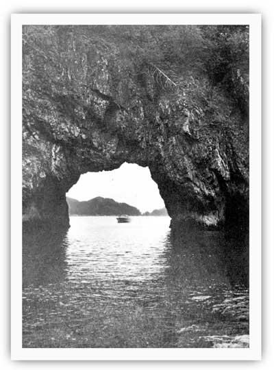
|
| Few sport fishers tested the park's waters prior to 1970, but in more recent years the park has become an increasingly popular destination. NPS photo, in Alaska Regional Profiles, Southcentral Region, July 1974, 94. |
In 1970, Seward was best known to tourists for the annual Silver Salmon Derby and the Mount Marathon race. During the 1970s, those activities continued. The growth of Anchorage and a general rise in leisure time activities also meant that an increasing number of tourists visited Seward, primarily in the summertime. Some of those tourists chartered boats and spent the day fishing in Resurrection Bay.
Relatively few, however, sailed to the south end of the bay or continued past Aialik Cape to the fjord country. Agency staff, as noted above, rarely saw sportsmen (either fishermen or hunters) in this area. In addition, a handful of sightseers flew over the Harding Icefield each summer. Northwest of Seward, a new road was being completed from the main highway west to Exit Glacier; almost no one used it, however, because of its rough surface and the lack of a bridge spanning the Resurrection River. Because no tourist facilities existed in these areas, and because recreational opportunities were usually available in less remote locations, commercial entities in the Seward and Homer areas saw no reason to advertise either the icefield or the fjord country southwest of Seward.
During the 1970s, area sport fishing grew more dramatically than it had in the 1960s, and by 1976, Seward was able to boast a number of businesses that profited from renting or chartering boats. One of those companies was Resurrection Bay Tours, established by Don Oldow in 1968. Oldow, a veteran ship pilot (he captained the ferryboat Tustumena), initially remained within the confines of Resurrection Bay. But in 1974, he began taking fishermen and sightseers out on the new, 43-foot M/V Shaman to the bays and fjords being considered in the various Interior Department proposals. By 1976, moreover, he was taking NPS and F&WS research personnel out into the fjord country. In 1977, Pam Oldow received her ocean operator license and began piloting her own tours. For the remainder of the decade, the couple operated regularly scheduled tours on Resurrection Bay; Aialik Bay tours were advertised (beginning in 1978) but were available only by request. [156] In 1980, anticipating tourist growth due to the new park, the Oldows became partners with Jack and Sheila Scoby (who owned the 43-foot Foxy Lady) and established Kenai Fjords Tours, Inc. Regular tours to Aialik Bay began not long afterward. The company, though no longer owned by either the Oldows or Scobys, remains an active part of the Seward tourist scene. [157]
By the late 1970s, several charter boat operators had taken clients into the fjord country; in addition, people who owned their own boat sailed into the area. The total number of visitors who headed that way is open to dispute. In 1977, an NPS official estimated that "about 200 recreationalists" each week visited either the Chiswell Islands or Aialik Bay. A state Fish and Game official made a more conservative guess; he estimated that between 50 and 100 boats per year visited the waters of the proposed park during the late 1970s. And a pair of wildlife biologists who spent the summer of 1980 in Aialik Bay estimated that perhaps 100 to 120 boats visited the bay between May and August, inclusively. [158] People apparently visited the fjord country in search of a wide variety of fish–salmon, halibut, rockfish, Dolly Varden and steelhead. Three trends brought more people into the fjords. First, the Silver Salmon Derby's increasing popularity caused participants to explore areas beyond Resurrection Bay. Second, the larger, more modern boats could maneuver through the fjord country in relative safety. The area also became better known because of the publicity brought by the various Alaska lands proposals. [159]
Harding Icefield, during the 1970s, became an increasingly popular destination. As noted above, bureaucrats in 1970 had forced a budding ski-and-snowmobile operation off the icefield after just two seasons. Although no on-the-ground development took place there for the remainder of the decade, air taxi operators took an increasing number of patrons on icefield flights. The Milepost and other promotional organs consistently publicized flightseeing trips to "one of Alaska's most spectacular attractions," and individual operators (such as Harbor Air Service and Trail Lake Flying Service) published flightseeing ads. [160] As to the number of flights that visited the icefield, little is known. Edward Murphy and Anne Hoover estimated that 0.3 aircraft per day (thus 10 per month) flew over Aialik Bay during the summer of 1979; as many as 20 per month visited the bay a year later. Regarding a traffic figure for the park as a whole, no data are available until 1982, two years after the park was established. The park superintendent estimated that 500 flights visited the park each summer: 150 from Seward and the remainder from Kenai and Homer. [161]
The Harding Icefield continued to lure a small number of the mountain-expedition fraternity. Not more than a handful crossed the icefield during the decade, one of whom was NPS employee Bill Resor. A few others climbed Phoenix Peak, located three miles west of Seward near the park's eastern boundary. [162]
One additional form of transport to the area was the Alaska Marine Highway. The ferry Tustumena, active since 1964, skirted the park's waters on its Seward-Kodiak runs. Few tourists, however, saw the park from the Tustumena. Service to Kodiak, in comparison to other Alaska Marine Highway routes, was fairly infrequent. It was not a major tourist attraction, and the Tustumena's route provided only distant glimpses of the Kenai Peninsula's southern coast. [163]
In the early 1970s, a new recreational opportunity loomed in the area when the Alaska legislature established Caines Head State Recreation Area. The state, as was noted in Chapter 8, selected land in the Caines Head area in 1962 and 1964. In 1971, 1,800 acres were transferred to the newly-created Alaska Division of Parks; three years later, more than 4,000 acres were added to create a 5,961-acre park that stretched more than seven miles along the bay's western shore from Tonsina Point to Rocky Point. Hopes were high that park development would quickly ensue. In 1979, plans were afoot to develop the area with a boat dock, hiking trails, camping shelters, a picnic area, and other amenities. That plan fell through, however, and the site was ignored for another five years. [164]
By the late 1970s, as has been noted, an increasing number of people were visiting the area within the park proposal, and both the icefield and the fjord country were no longer the terra incognita that they had been a decade earlier. Despite those changes, the area was still so remote–and visitation so light–that many people, both in Seward and elsewhere in Alaska, wondered why government agencies were expending so much effort to preserve the area. As John Madson noted in a 1978 Audubon article,
Most of Seward's boat traffic stays on Resurrection Bay, which offers all any reasonable person could want in the way of sheltered boating, salmon fishing, highlining for bottom fish, scenery, and enough company to make a weekend skipper feel secure.... The Kenai Fjords area ... is surely the least-known [park proposal]. By default rather than by design, it is one of Alaska's best-kept secrets. [165]
Madson noted that Seward residents were initially leery of the NPS's proposal, primarily because they didn't want the federal government having more of a presence. By the late 1970s, however,
the majority of Seward residents are evidently in favor of the Kenai Fjords National Park — or if not actually in favor of it, they're at least getting used to the idea.... Few of the commercial fishermen and charter captains can understand why any party of 6 people would hire a boat at $300 per day just to go out and look at seabirds and sea lions — but that $300 isn't hard to understand. [Local residents are] somewhat puzzled by all the attention being paid to features they often take for granted. [166]
In the years since the park's establishment, visitation has continued to rise. Tourism in the Seward area, based both on tours to the park and a variety of other activities, is now a mainstay of the local economy. In 1997, more than 300,000 people made a recreational visit to the park; given those numbers, Kenai Fjords has become one of the most popular national park destinations in Alaska. All signs point to a continuation of existing trends.
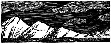
|
| Illustration by Rockwell Kent from Wilderness: A Journal of Quiet Adventure in Alaska, 1920. The Rockwell Kent Legacies. |
kefj/hrs/chap10.htm
Last Updated: 26-Oct-2002