|
Kennesaw Mountain National Battlefield Park Georgia |
|
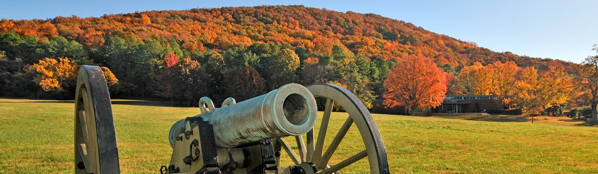 NPS photo | |
The Road Past Kennesaw: The 1864 Atlanta Campaign
Ulysses S. Grant assumed command of all Federal armies in March 1864 and ordered a coordinated offensive to destroy Confederate resistance and end the war. The major efforts focused on eastern Virginia and northwestern Georgia.
Grant accompanied Maj. Gen. George G. Meade who led the Army of the Potomac against Gen. Robert E. Lee's Army of Northern Virginia. From a position near Chattanooga, Tennessee, Maj. Gen. William T. Sherman led the Georgia offensive against Gen. Joseph E. Johnston's men, entrenched along Rocky Face Ridge at Dalton, Georgia. Grant ordered Sherman to "move against Johnston's army, to break it up, and to get into the interior of the enemy's country as far as you can, inflicting all the damage you can against their war resources."
Over the past three years the Confederacy had lost control of the Mississippi River, most of Tennessee, and much of Mississippi. Yet its heartland remained mostly untouched by the war. A still intact belt of manufacturing communities stretched from Augusta, Georgia, to Selma, Alabama, with the major city of Atlanta at its center.
Even more important, Atlanta harbored a vital Confederate rail junction. Four railroads met here, linking the southern Atlantic seaboard states with the western Confederacy. The Western & Atlantic Railroad linked Atlanta with Chattanooga, to the northwest, and carried supplies for both sides. Its tracks formed the axis of the Atlanta Campaign. The Georgia Railroad ran east to Augusta, where it connected with lines to Charleston, Raleigh, and the Confederate capital of Richmond. The Macon & Western ran southeast, with connections to Savannah. Just south of Atlanta, at East Point, the Atlanta & West Point extended west into Alabama.
From May to September 1864, Federal and Confederate forces clashed across northern Georgia, from Dalton to Atlanta, in fierce battles and almost daily skirmishes and maneuvers. During the final siege of Atlanta, Sherman's troops cut the city's rail links. Confederate troops evacuated the city on September 1; Sherman entered the following day. Atlanta had fallen.
You cannot qualify war in harsher terms than I will. War is cruelty and you cannot refine it.
—William T. Sherman, General, US Army
The Civil War in the Western Theater, 1861-64
Southern states secede; Fort Sumter bombarded;
war begins.
Dec. 1860-April 1861
Kentucky ends neutrality, comes under Union
control.
Sept. 1861
Union takes forts Henry and Donelson; controls
Tennessee River.
Feb. 1862
Union take Island No. 10, then Memphis, on
Mississippi River.
Feb., June 1862
Union victory at Battle of Pea Ridge establishes
control of Missouri.
March 1862
Union victory at Shiloh opens way into northern
Mississippi.
April 1862
Union Navy takes New Orleans; gain access to
Mississippi River.
April 1862
Battle of Stone River secures middle Tennessee
for Union.
Jan. 1863
Grant take Vicksburg, opens Mississippi River,
splitting Confederacy.
Jan-July 1863
At Chickamauga, South gains greatest victory in
western theater.
Sept. 1863
The Campaign Begins
Sherman began his march on Atlanta on May 7. Two days later he approached General Johnston's position on a steep ridge called Rocky Face. Sherman sent a column through Snake Creek Gap to threaten the Western & Atlantic Railroad, Johnston's supply connection with Atlanta. After leaving Rocky Face, Johnston moved south and dug in at Resaca, where from May 13 to 15 he repulsed Sherman's attacks.
When a Union column swung west to cross the Oostanaula River and again threaten the railroad, Johnston retreated to Adairsville, where the two forces skirmished on the 17th. They halted at dusk, when Johnston fell back.
As Sherman advanced toward Atlanta he tried to contain the entrenched Confederates with part of his force while sending another column around their flank—always trying to sever the Western & Atlantic Railroad supply lines. Johnston repeatedly withdrew to intercept the threats.
By late May Johnston had pulled back to a position in the Allatoona Mountains. Sherman swung wide to the southwest, but Johnston sidestepped and slowed his progress with fighting at New Hope Church, Pickett's Mill, and Dallas, May 25 to 28. Sherman resumed his advance on June 10. When forced to swing eastward, he followed a bend in the railroad to avoid straying too far from his own supply line.
Battle for Kennesaw
By June 19, despite weeks of continual rain, Sherman's troops forced Johnston to withdraw again, this time to prepared defensive position anchored by Kennesaw Mountain, a lofty ridge with rocky slopes rising above the surrounding plain. Using enslaved labor, Confederate engineers had laid out elaborate trenches from which cannon and rifle fire greeted the enemy's approach from any direction.
Again Sherman extended his lines to the south to get around the Confederate flank. Again Johnston countered, shifting 11,000 men under Gen. John Bell Hood to meet the threat. At Kolb's Farm on June 22 Hood struck savagely but unsuccessfully. He failed to repel the Northerners.
Immobilized by muddy roads, Sherman suspected that Johnston's defenses, though strong, might be thin. One sharp thrust might break through. He diverted Johnston's attention with attacks on Kennesaw and the Confederate !eft flank, then leveled a two-pronged attack on the enemy's center.
The attacking brigades moved into position before dawn on June 27. At 8 am, after an artillery bombardment, they surged forward. Both attacks were brief, bloody failures. Astride Burnt Hickory Road three Union brigades totaling 5,500 men crossed swampy, heavily wooded terrain. Before they could reach their objective—a mountain spur today called Pigeon Hill—sheets of fire drove them under cover. From Little Kennesaw and Pigeon Hill, Confederates rolled rocks down on the Union soldiers. Sherman recalled the attack when he saw that it could not succeed.
Meanwhile, on a hill south of Dallas Road (now Dallas Highway), 8,000 Union infantrymen attacked two entrenched divisions of Johnston's army. Many in the assaulting waves were shot down. Some advanced to close quarters, and for a few minutes brutal hand-to-hand fighting occurred on top of the defenders' earthworks. Both sides grimly nicknamed this place the "Dead Angle."
Sherman resumed his flanking strategy, forcing Johnston to abandon his Kennesaw lines during the night of July 2. The Confederates had lost 800 men, the Northerners 1,800, but the Union's diversionary movement on the Confederate left had an unforeseen benefit. It placed Sherman closer to Chattahoochee River crossings. He surprised Johnston by sending a small force across the river upstream from where Confederates guarded the railroad bridge. Outflanked again, Johnston had to retreat across the Chattahoochee.
The Fall of Atlanta
The rest of Sherman's army crossed the Chattahoochee on July 9 and Johnston withdrew to the fortifications of Atlanta. For Confederate President Jefferson Davis, already exasperated by Johnston's fallbacks and lack of aggressiveness, this was the last straw. He relieved Johnston of command and replaced him with General Hood. Meanwhile, Sherman was closing on Atlanta from the north and east. Hood tried unsuccessfully to destroy the army of Gen. George H. Thomas as it crossed Peachtree Creek on July 20.
Two days later, at the Battle of Atlanta, Hood struck at Gen. James B. McPherson's army. The Confederates suffered heavy losses. Planning to outflank Atlanta's defenders, Sherman swung west of the city, where at Ezra Church, on July 28, Hood lashed out again. He met with defeat.
In August, Sherman placed Atlanta under siege, continually shifting troops to cut the city's rail links to the rest of the South. On August 31 he seized the last one, the Macon & Western. After Hood lost a two-day battle near Jonesboro, he ordered all public property destroyed and the city evacuated. Sherman entered on September 2 and triumphantly telegraphed the news to Washington: "Atlanta is ours, and fairly won."
Atlanta's fall crippled the Confederacy's capacity and will to make war. Coupled with Union victories elsewhere, the war's end was now in sight. In the North people rejoiced, and on November 8 reelected President Abraham Lincoln, endorsing a fight to the finish. A week later Sherman left Atlanta in ruins and began his "March to the Sea."
Union and Confederate Leadership Confederate Gen. Joseph E. Johnston repeatedly frustrated Union Gen. William T. Sherman's attempts to outmaneuver him. Johnston's failure to stop the Federals, however, caused Jefferson Davis to replace him with Gen. John Bell Hood. Hood fought hard to save Atlanta, but supply and morale problems forced him to abandon the city.
Life in Cobb County and on the Battlefield
Settlers moved into Cobb County's rolling countryside in the 1830s, after the US government took the land from the Cherokee under the 1830 Indian Removal Act. Though still known as "Cherokee Georgia" into the 1860s, by then it had become one of the most populous, wealthy counties in the northwestern part of the state.
Much of the prosperity derived from the Western & Atlantic Railroad. Completed by 1850, it gave access to distant markets and attracted new emigrants from Georgia and other parts of the nation. The town of Kennesaw, then Big Shanty, began as a construction camp for workers laying rails for the Western & Atlantic.
Most small planters and farmers in the Kennesaw Mountain region lived in log cabins and later built small frame houses. They typically owned fewer than 10 enslaved workers and probably toiled alongside them. Of the county's population of 14,242 people, 3,819 were enslaved.
Cotton was the area's cash crop. Farmers also produced food and pastured livestock, especially hogs. Some owned horses or mules; most used oxen as draft animals.
The large Roswell Mills complex produced textiles, including "Roswell Grey" for Confederate uniforms. The area also had grist mills, tanneries, and sawmills.
An 1864 article in the New York Tribune described Marietta, the county seat, as "a perfect grotto of shade .... There were during good times, sixteen stores, two druggists, eight groceries, three hotels, four churches .... Methodist, Baptist, Presbyterian and Episcopal, three female and one male school besides small schools for young children, all well patronized .... "
Many families from coastal Georgia and South Carolina built fine homes in Marietta. They sought the healthier climate of Piedmont Georgia during the summer malaria season. One Union soldier declared tha Marietta was "the prettiest town in Northern Georgia."
Not everyone in Marietta enjoyed a high standard of living. Of the 2,680 residents, nearly half were enslaved, and only 13 free African Americans are registered in the 1860 county census. Free but not equal, they endured many restrictive state laws and local codes.
Touring Kennesaw Mountain National Battlefield Park
This self-guiding auto tour takes you to the major points of interest. Each tour stop has parking and wayside exhibits. Short interpretive trails are located on the mountaintop, at Pigeon Hill, and at Cheatham Hill.
Kennesaw Mountain An overlook near the summit offers a panoramic view of Atlanta and the northern Georgia terrain where Sherman's and Johnston's armies struggled in the late spring and summer of 1864. A short, moderately steep trail leads to the summit. Along the way are exhibits and gun emplacements dug by Confederates to control the Western & Atlantic (now CSX) Railroad.
24-Gun Battery Located on a small, wooded rise facing Little Kennesaw and Pigeon Hill, this Federal gun emplacement accommodated four batteries, each containing six artillery pieces. These guns bombarded Confederate forces on Kennesaw Mountain off and on for 10 days.
Wallis House Josiah Wallis built this house about 1853. He abandoned it as Sherman's armies began their approach. Union Gen. Oliver O. Howard's used it as his headquarters during the Battle of Kennesaw Mountain. It was earlier used as a Confederate hospital. General Sherman was at the Wallis House during the battle at Kolb's Farm.
Pigeon Hill A foot trail leads to Confederate entrenchments on this mountain spur, where one of Sherman's two major attacks was repulsed.
Cheatham Hill To protect this hill, now named for Confederate Gen. Benjamin F. Cheatham, the Southerners created a salient (a protruding angle) in their lines. The fiercest fighting of the battle raged here at what came to be called the "Dead Angle." Along the trail to the imposing Illinois Monument, you'll see Confederate earthworks and markers where Union soldiers fell.
Sherman/Thomas Headquarters The two Union generals met here to discuss, and ultimately order, an ill-fated frontal assault against Confederate Gen. William Hardee's troops entrenched atop Cheatham Hill.
Kolb's Farm On the afternoon of June 22, 1864, Union soldiers repulsed Confederate General Hood's ill-fated attack just north of Powder Springs Road. Union Gen. Joseph Hooker used the Kolb House for his headquarters after the fight. The Kolb family cemetery is adjacent to the house.
Kolb's Farm Peter Valentine Kolb II, one of Cobb County's earliest settlers, built this log house in the 1830s. He ran a self-sufficient farm of about 600 acres with 10 enslaved workers. The family fled as Federal troops approached along Powder Springs Road in 1864, and only returned in the 1880s. The June 22nd battle damaged the house and destroyed several outbuildings. The house has been restored to its historic appearance.
Illinois Monument The Illinois Monument on Cheatham Hill is the largest monument on the battlefield. Dedicated in 1914, it honors the Illinois soldiers who served. You can see the entrance to a tunnel, dug by Union soldiers, near its base. They began it intending to blow up the Confederate position with a land mine.
Georgia Monument The Georgia Monument, dedicated in 1963 during the Civil War centennial, honors all Georgians who served. Although Georgia troops did not fight at Kennesaw, the monument is installed at the foot of the mountain.
Your Visit to the Battlefield
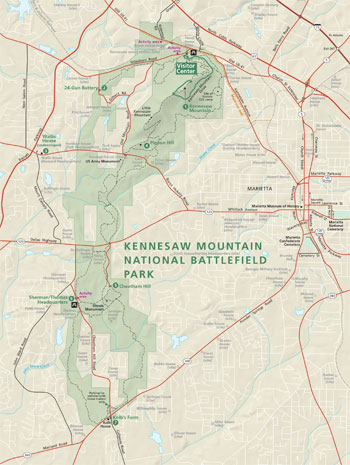 (click for larger map) |
Begin at the visitor center, where you'll find information, a short film, exhibits, and a bookstore. All are open daily except Thanksgiving, December 25, and January 1. Park staff can answer questions and help you plan your visit. Hours of operation vary seasonally; for specific times visit www.nps.gov/kemo.
This is a day-use-only park, without any overnight facilities. Hours are posted at all gated lots. Please read them. Vehicles left at the park after posted closing times may be ticketed and towed at the owner's expense.
The park has monuments, historical markers, cannon emplacements, and 22 miles of trails. Programs are offered on peak season weekends. You must use the shuttle bus (on the hour and half-hour starting at 10 am) to reach the mountaintop on weekends. Fee.
Trails Park trails offer short walks and long hikes. Starting at the visitor center the roundtrip distances are 2, 6, 11, and 17 miles. All trails require moderately steep climbing and many offer a mix of flora and fauna. Drinking water is limited; food and shelter are not available along trails. Conditions can be hazardous. Stay on trails, wear sturdy shoes, and be sure to carry water.
Accessibility The visitor center offers a museum tour for people with sight or vision loss. Trails have remained natural and have not been altered. The mountain road is paved. Our ADA-approved shuttle bus can accommodate special needs. We strive to make our facilities, services, and programs accessible to all.
Getting Here From I-75, take exit 269 and drive 2.1 miles west on Barrett Parkway. Turn left onto Old US 41 and proceed 1.2 miles to Stilesboro Road at the first traffic light after entering the park. Turn right onto Stilesboro Road, then left through the park gate into the visitor center parking lot.
Safety and Regulations
Park only in designated areas. • All natural and cultural resources
are protected by federal law. Do not climb on cannons, monuments, or
earthworks. Disturbing fragile earthworks can cause irreparable damage.
• Stay on roads and trails to help prevent erosion and protect the
mountain terrain. • Picnicking and all recreational activities are
restricted to designated areas. • Alcoholic beverages are
prohibited. • Watch for insects, snakes, and poisonous plants.
• Pets must be on leashes no longer than 6 feet. They are not
allowed in the visitor center, restrooms, or shuttle bus. Clean up after
your pet; use bags available in the parking lots. Protect pets from
heat-related illness by keeping them cool and hydrated. Never leave pets
unattended in a vehicle. • Bicycles are prohibited on hiking
trails. • Possession or use of metal detectors is unlawful. •
For firearms regulations check the park website.
Nearby Points of Interest
Southern Museum of Civil War and Locomotive History Exhibits
offer a glimpse into Civil War soldiers' daily lives; a reproduction of
an early 1900s locomotive assembly line from the Glover Machine Works;
and the General, the locomotive used during the Civil War battle known
as Andrews' Raid, or the Great Locomotive Chase.
Marietta Museum of History Housed in a cotton warehouse built in 1845, the collections focus on local history nd home life.
Marietta National Cemetery The Marietta National Cemetery is the site of over 10,000 Union graves. Hoping to heal ill feelings between North and South, Henry Green Cole donated the land for a joint cemetery, but his vision was never realized.
Marietta Confederate Cemetery This is the final resting place for 3,000 Confederate soldiers who died in nearby hospitals and battles, including those at Kalb's Farm and Kennesaw Mountain.
Source: NPS Brochure (2017)
|
Establishment
Kennesaw Mountain National Battlefield Park — October 25, 1947 (established) |
For More Information Please Visit The  OFFICIAL NPS WEBSITE |
Documents
A Case Study of the Potential Impacts of Neighboring Land Use Patterns on Local Ecosystems within Protected Federal Lands, Kennesaw Mountain National Battlefield Park NPS Natural Resource Report NPS/SECN/NRR-2011/473 (Brent Blankley, December 2011)
Amphibian Community Monitoring at Kennesaw Mountain National Battlefield Park, 2011 NPS Natural Resource Data Series NPS/SECN/NRDS-2013/529 (Briana D. Smrekar, Michael W. Bryne, Marylou N. Moore and Aaron T. Pressnell, August 2013)
Amphibian Community Monitoring at Kennesaw Mountain National Battlefield Park, 2012 NPS Natural Resource Data Series NPS/SECN/NRDS-2013/548 (Briana D. Smrekar, Michael W. Bryne, Lisa Kleinschmidt and Nathan P. Schwartz, September 2013)
An Administrative History: Kennesaw Mountain National Battlefield Park (HTML edition) (Michael A. Capps, 1994)
Assessment of Water Resources and Watershed Conditions in Kennesaw Mountain National Battlefield Park, Georgia NPS Natural Resource Report NPS/SECN/NRR-2010/273 (JoAnn M. Burkholder, December 2010)
Cultural Landscape Report, Kennesaw Mountain National Battlefield Park (Wiss, Janney, Elstner Associates, Inc. and John Milner Associates, Inc., November 2013)
Cultural Landscape Report: Signal Hill and Field Hospital at the Wallis Farm, Environmental Assessment, Kennesaw Mountain National Battlefield Park (Quinn Evans, November 2021)
Cultural Landscapes Inventory: Kennesaw Mountain National Battlefield Park (2009)
Folleto de Joven Guardabosque, Kennesaw Mountain National Battlefield Park (Date Unknown; solo para fines de referencia)
Foundation Document, Kennesaw Mountain National Battlefield Park, Georgia (July 2013)
Foundation Document Overview, Kennesaw Mountain National Battlefield Park, Georgia (August 2013)
General Management Plan/Environmental Assessment, Kennesaw Mountain National Battlefield Park (1983)
Geologic Map of Kennesaw Mountain National Battlefield Park, Georgia (October 2021)
Geologic Resources Inventory Report: Kennesaw Mountain National Battlefield Park NPS Natural Resource Report NPS/NRSS/GRD/NRR—2021/2324 (Michael Barthelmes, November 2021)
Historic Resource Study: Kennesaw Mountain National Battlefield (Robert W. Blythe, Maureen A. Carroll and Steven H. Moffson, March 1995)
Junior Ranger Book, Kennesaw Mountain National Battlefield Park (Date Unknown; for reference purposes only)
Landbird Community Monitoring at Kennesaw Mountain National Battlefield Park, 2009 NPS Natural Resource Report NPS/SECN/NRDS—2011/307 (Michael W. Byrne, Joseph C. DeVivo, Jennifer R. Asper and Brent A. Blankley, September 2011)
Landbird Community Monitoring at Kennesaw Mountain National Battlefield Park: 2012 Data Summary NPS Natural Resource Data Series NPS/SECN/NRDS—2016/1017 (Elizabeth A. Kurimo-Beechuk and Michael W. Byrne, May 2016)
Long-Range Interpretive Plan, Kennesaw Mountain National Battlefield Park (December 2010)
Master Plan for the Preservation and Use of Kennesaw Mountain National Battlefield Park (October 1961)
National Register of Historic Places Nomination Form
Kennesaw Mountain National Battlefield Park (Charles L. Vial and E. Paul Engstrom, September 6, 1973)
State of the Park Report, Kennesaw Mountain National Battlefield Park, Georgia State of the Park Series No. 8 (November 2013)
Superintendent's Annual Narrative: 1996 • 1998 • 1999 • 2000
Summary of Vocal Anuran Monitoring at Kennesaw Mountain National Battlefield Park, 2009 NPS Natural Resource Data Series NPS/SECN/NRDS—2011/154 (Michael W. Byrne, Briana D. Smrekar, Marylou N. Moore and Casey S. Harris, March 2011)
The Atlanta Campaign and Kennesaw Mountain National Battlefield Park, Georgia (1942)
The Road Past Kennesaw: The Atlanta Campaign of 1864 (Richard M. McMurry, 1972)
The War of Jubilee: Tell Our Story and We Will Come — Assessing African American Attitudes Towards the Civil War Focus Group Final Report (Hermina Glass-Avery, January 2011)
Vegetation Community Monitoring at Kennesaw Mountain National Battlefield Park, 2011 NPS Natural Resource Data Series NPS/SECN/NRDS—2014/706 (Sarah Corbett Heath and Michael W. Byrne, October 2014)
Vegetation Community Monitoring at Kennesaw Mountain National Battlefield Park, 2012 NPS Natural Resource Data Series NPS/SECN/NRDS—2014/712 (Sarah Corbett Heath and Michael W. Byrne, October 2014)
Vegetation Mapping at Kennesaw Mountain National Battlefield Park NPS Natural Resource Report NPS/SECN/NRR-2015/1088 (Rachel H. McManamay, November 2015)
Vegetation Monitoring at Kennesaw Mountain National Battlefield Park, Cobb County, Georgia: A Report on the Summer 1994 Field Season (Matthew S. Barnett-Lawrence, Anthony V. Keeler, James H. Graves and Peter S. White, December 1994)
Wee Ranger Book, Kennesaw Mountain National Battlefield Park (Date Unknown; for reference purposes only)
National Park Planner's Kennesaw Mountain National Battlefield Park
kemo/index.htm
Last Updated: 01-Jan-2025