|
Lava Beds National Monument California |
|
 NPS photo | |
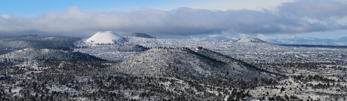
500,000 YEARS AGO THE EARTH OPENED
Cracking and sputtering, it released liquid rock and rivers of fire across the landscape. Intermittent eruptions over thousands of years layered the land, leaving intricate caves, cones, craters, and black, jagged blankets of lava. The Modoc called this "the land of burnt-out fires." Tule Lake and Lava Beds were then, and are today, the center of their world.
This can be a forbidding place, a world foreign to outsiders. The Modoc and their ancestors lived in this rugged land for over 10,000 years. Following the rhythms of nature, they moved freely across their homeland until they were forcibly removed.
The blazing of the Applegate Trail through the heart of Modoc territory was the beginning of the end for the traditional Modoc way of life. Increasing numbers of white settlers claimed ancestral Modoc land, conflicts escalated, and both sides resorted to violent attacks. By the 1860s settlers demanded area tribes be moved to the Klamath Reservation in Oregon. The Modoc reluctantly signed a treaty, but consistently requested a reservation in their homeland. Poor conditions and disagreements with other tribes on the reservation convinced some Modoc to return home. Broken promises, bitter resentments, and distrust made negotiations impossible.
The Modoc War began on November 29, 1872, when troops from Fort Klamath tried to force the resisting Modoc back to the reservation. They fled to the natural fortress of the lava beds, to what is today called "Captain Jacks Stronghold." In April 1873 peace talks began. Toby Riddle, a Modoc woman married to white settler Frank Riddle, served as an interpreter between the Modoc and the army. Kientpoos (Captain Jack) wanted his people to be allowed to stay in their homeland.
He also wanted peace. Modoc society ruled by consensus. Remembering the 1852 slaughter of 30 members of their tribe, a majority voted to eliminate the peace commissioners. On April 11, 1873, peace commissioners Gen. Edward Canby and Rev. Eleazar Thomas were killed. Gen. William T. Sherman soon called for the "utter extermination" of the Modoc.
For six months 1,000 troops and volunteers fought to capture fewer than 60 Modoc warriors and their families. Those who resisted were exiled to the Quapaw Agency in Oklahoma.
MEDICINE LAKE VOLCANO
Medicine Lake is a shield volcano that has been active for 500,000 years. Its eruptions, from nearly 520 surface vents, have been gentle rather than explosive. This has resulted in a low, gently-sloping, shield-like profile. Today you can see evidence of over 30 separate lava flows throughout the park.
FROM LAVA TUBES TO CAVES
Eruptions occurring 30-40,000 years ago formed over 700 lava tube caves found in the park. Lava tubes form when streams of hot, flowing lava start to cool. The center of the stream stays hot and continues to flow as the outside begins to cool and harden. The hot lava drains out, leaving a pipe-like cave. Multiple eruptions can stack caves on top of one another, creating multilevel caves. When a lava tube ceiling collapses, it opens access to the cave below.
LAND OF BURNT-OUT FIRES
The Modoc life and culture was perfectly tuned to this environment and the richness of the resources it provided. They lived in semi-permanent winter villages along Lost River and Tule Lake. Each year as winter turned to spring, they began a seasonal round of fishing, hunting, and gathering. Ragged and rough, the terrain of the lava flows could be dangerous, but to the Modoc it was a sacred landscape. It provided bounty in the hunt and challenged those seeking power and knowledge through vision quests.
Make the Most of Your Visit to Lava Beds
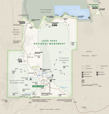 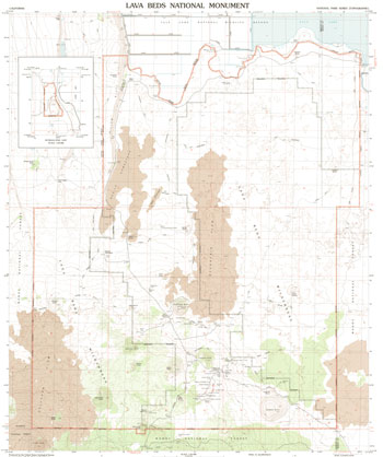 (click for larger maps) |
Established in 1925, Lava Beds National Monument protects and interprets this volcanic land, its early human occupation, and the Modoc defense of their homeland. Learn about activities and trails at the visitor center.
Some roads outside the park are closed during the winter and early spring.
The visitor center bookstore has snacks, ice, flashlights, helmets, videos, batteries, books, and souvenirs.
Gas, firewood, restaurants, and showers are available in nearby communities of Tionesta, CA; Tulelake, CA; and Merrill, OR (20-40 minutes from the visitor center).
Accessibility We strive to make facilities and programs accessible to all. Please call, ask at the visitor center, or go to our website for more information.
For firearms regulations check the park website or ask a park ranger.
Follow us on Facebook and Twitter, and Instagram.
EXPLORING ABOVE GROUND
There is much to see and do at Lava Beds. Highlights include:
Mammoth Crater Impressive 36,000 year old vents that created lava tube caves in the area.
Symbol Bridge/Big Painted Cave Marvel at prehistoric pictographs and artwork.
Schonchin Butte Hike the trail to the fire lookout built by the Civilian Conservation Corps.
Fleener Chimneys View volcanic vents and spatter cones created by globs of lava.
Thomas-Wright Battlefield Visit the site of a decisive Modoc victory over the US Army.
Gillems Camp/Gillem Bluff Hike to a great view of this volcanic landscape.
Captain Jacks Stronghold Explore where Modoc families took refuge as they fought for their homeland.
Wildlife Overlooks Stop and view waterfowl on Tule Lake.
Petroglyph Point Visit this former island with ancient carvings that is significant to native cultures.
Wilderness Congress has protected 28,460 acres of Lava Beds National Monument as wilderness under the 1964 Wilderness Act. Information about the National Wilderness Preservation System can be found at www.wilderness.net.
EXPLORING THE CAVES
Before entering a cave, you are required to obtain a permit at the visitor center or fee booth.
Many of the 700-plus caves have steep entry points, rocky trails, and, in some cases, very low ceilings. Over two dozen caves have developed entrances and trails. They vary in difficulty, length, and complexity. Start at the visitor center for screening, information, and to talk to a ranger about the caves.
CAVE SAFELY
Wear Protective Clothes Caves are about 55°F (13°C) year-round, however caves with ice are colder. Wear long sleeves, pants, and closed-toe footwear. Helmets, gloves and kneepads are recommended in moderately and most challenging caves.
Bring Enough Light Each person should carry at least one flashlight with extra batteries. Flashlights are loaned free of charge at the visitor center.
Protect Your Head Wear a helmet in all caves. Bump hats are sold at the visitor center.
Don't Go Alone Choose caves suitable for everyone in your group. Don't push beyond anyone's limits.
Know Your Route Be observant. Be aware of junctions and landmarks. A cave map book can be purchased at the visitor center. Tell someone where you are going.
CAVE SOFTLY
• Caves are amazing, fragile environments. Please take only
pictures and leave only footprints. Leave no trace.
• Do not eat, drink, smoke, or leave trash.
• Cave slowly and carefully.
• Do not use caves as bathrooms.
• Stay on the trails.
• Do not touch cultural artifacts, paintings, cave formations, or
gold and silver microbial mats.
• Use electric flashlights, not carbide or gas lamps.
• Do not disturb any cave life.
• Pets are not allowed in caves.
HELP PROTECT OUR BATS
Get a Permit If you plan on entering any cave in Lava Beds National Monument, stop by the visitor center or fee booth and obtain a permit.
Display your pass in your windshield to show you have been through the screening process and are helping protect the bats that live here.
If you have gear that has been used in caves or mines in the US, Canada, or Europe, please leave these items at home or in your car. If used, this gear must be properly decontaminated.
White-Nose Syndrome Since 2006, bats have been dying in unprecedented numbers in the eastern United States and Canada from white-nose syndrome, a fatal condition associated with exposure to fungus. Humans can spread the fungus between caves, mines, and other bat roost sites. Help us prevent the spread of this devastating disease.
Source: NPS Brochure (2017)
|
Establishment Lava Beds National Monument — November 21, 1925 |
For More Information Please Visit The  OFFICIAL NPS WEBSITE |
Documents
A Biological Assessment of Caves in Lava Beds National Monument Final Report (Steven J. Taylor and Jean K. Krejca, April 20, 2006)
A Flora of Lava Beds National Monument (S.B. Smith, 2014)
A Flora of Lava Beds National Monument (©Sean Bryan Smith, Master's Thesis Southern Oregon University, 2008)
A Geologic and Hydrologic Reconnaissance of Lava Beds National Monument and Vicinity, California USGS Open-File Report 68-140 (W.R. Hotchkiss, 1968)
A Preliminary Investigation of Cave Ice at Lava Beds National Monument, northern California (Edward Brook, Lacey Little and Shane Fryer, Date Unknown)
Acoustical Monitoring Report, Lava Beds National Monument NPS Natural Resource Report NPS/LABE/NRR—2017/1409 (Ashley R. Pipkin, April 2017)
Accessibility Self-Evaluation and Transition Plan, Lava Beds National Monument, California (March 2016)
Analyzing Front Country Social Trails Data from Lava Beds National Monument (Leslie Veal, Date Unkown)
Captain Jack's Stronghold USGS Professional Paper 838 (David A. Johnston and Julie Donnelly-Nolan, eds., 1981)
Captain Jack's Stronghold Registered Landmark #9 (John Samuel Fox, 1936)
Captain Jack's Stronghold: The Geologic Events that Created a Natural Fortress (Aaron C. Waters, extract from California Geology, Vol. 45 No. 5, September-October 1992, ©California Department of Conservation)
Cave Management Plan Newsletter #1, Lava Beds National Monument (May 2008)
Cultural Landscapes Inventory: Modoc War Historic District (2005)
Fern Cave Management Plan (February 2006)
Fire History and Ecology, Lava Beds National Monument (Arlen H. Johnson and Garrett A. Smathers, extract from Fire Ecology Conference Proceedings, Vol. 15, 1976)
Fire Management Plan — Environmental Assessment, Lava Beds National Monument (Mary Rasmussen, September 2004)
Fire regimes pre- and post-settlement vegetation, and the modern expansion of western juniper at Lava Beds National Monument, California: 2003 Final Report (Rick Miller, Emily Heyerdahl and Karl Hopkins, 2003)
Foundation Document, Lava Beds National Monument, California (February 2017)
Foundation Document Overview, Lava Beds National Monument, California (January 2017)
General Base Map, Lava Beds National Monument (March 1963)
General Management Plan & Environmental Impact Statement Draft (November 1995)
General Management Plan & Environmental Impact Statement, Lava Beds National Monument, California (June 1996)
General Management Plan and Environmental Assessment, Lava Beds National Monument Draft (September 2010)
General Management Plan Newsletters: Newsletter 1: May 2006 • Newsletter 2: July 2007 • Newsletter 3: January 2008
Geologic Map of Lava Beds National Monument, Northern California USGS Map I-1804 (Julie M. Donnelly-Nolan and Duane E. Champion, 1987)
Geologic Resources Inventory Report, Lava Beds National Monument NPS Natural Resource Report NPS/NRPC/GRD/NRR-2014/804 (K. KellerLynn, April 2014)
Geology of Prisoners Rock and The Peninsula: Pleistocene Hydrovolcanism in the Tule Lake Basin, Northeastern California (Alexis Lavine, extract from California Geology, Vol. 47 No. 4, July-August 1994, ©California Department of Conservation)
Going Down the Tubes (Bruce W. Rogers, extract from California Geology, Vol. 45 No. 5, September-October 1992, ©California Department of Conservation)
Historical Misunderstandings About Lava Tube Systems and Lava Tube Caves of Lava Beds National Monument, California (Charles V. Larson, 6th International Symposium on Vulcanospeleology, 1992)
Historical Survey of Developments at Lava Beds National Monument (Gordon Chappell, 1980)
History of the Modoc National Forest, United States Forest Service — California Region (William S. Brown, Sr., September 1, 1945)
Hydrogeology and Water Supply Wells, Lava Beds National Monument NPS Natural Resource Report NRR/NRPC/WRD/NRTR-2007/373 (Larry Martin, June 2007)
Ice Cave Monitoring at Lava Beds National Monument (Katrina Smith, extract from Proceedings of the 6th International Workshop on Ice Caves, 2014, &copoy;National Cave and Karst Research Institute)
Impacts of Visitor Spending on the Local Economy: Lava Beds National Monument, 2007 (Daniel J. Stynes, March 2009)
In the Footprints of Gmukamps: A Traditional Use Study of Crater Lake National Park and Lava Beds National Monument (Douglas Deur, 2008)
Klamath Network Landbird Monitoring Annual Report: 2008 results from Oregon Caves National Monument, Lava Beds National Monument, and Redwood National and State Parks NPS Natural Resource Technical Report NPS/KLMN/NRTR—2009/191 (Jaime L. Stephens, John D. Alexander and Sean R. Mohren, March 2009)
Klamath Network Landbird Monitoring Annual Report: 2011 Results from Oregon Caves National Monument, Lava Beds National Monument, and Redwood National and State Parks NPS Natural Resource Data Series NPS/KLMN/NRDS—2012/317 (Jaime L. Stephens and Sean R. Mohren, May 2012)
Klamath Network Landbird Monitoring Annual Report: 2014 Results from Oregon Caves National Monument, Lava Beds National Monument, and Redwood National and State Parks NPS Natural Resource Data Series NPS/KLMN/NRDS—2015/816 (Jaime L. Stephens, August 2015)
Land Cover and Land Use Monitoring: 2016 Results for Lava Beds National Monument NPS Natural Resource Data Series NPS/KLMN/NRDS—2017/1107 (Jace Ives, Allison Snyder, Elizabeth Edson, Jacob King, Lorin Groshong Sean Mohren, June 2017)
Lava Beds Caving Guide (National Speleological Society, October 10, 2010)
Lava Tube Systems of Lava Beds National Monument (Charles V. Larson, 6th International Symposium on Vulcanospeleology, 1992)
Layers of Meaning: An Administrative History of Lava Beds National Monument, 1925-2006 (Matthew Godfrey and Paul Sadin, 2009)
Long-Range Interpretive Plan, Lava Beds National Monument (Interpretive Solutions, Inc., September 2010)
Map: Indian Well Area (October 1936)
Map: Skull Cave (June 1937)
Medicine Lake Volcano and Lava Beds National Monument (Julie M. Donnelly-Nolan, extract from California Geology, Vol. 45 No. 5, September-October 1992, ©California Department of Conservation)
Modoc War: 1872-73, Lava Beds National Monument (Erwin N.Thompson, October 1, 1967)
Modoc War: Its Military History & Topography (Erwin N. Thompson, 1971)
Monitoring the Disappearance of a Perennial Ice Deposit in Merrill Cave (Kelly Fuhrmann, extract from Journal of Cave and Karst Studies, Vol. 69 No. 2, August 2007)
Monitoring Vegetation Composition, Structure, and Function in Lava Beds National Monument and Redwood National and State Parks: Fiscal Year 2011 Annual Report NPS Natural Resource Data Series NPS/KLMN/NRDS—2013/447 (Sean B. Smith and Daniel Sarr, February 2013)
Monitoring Vegetation Composition, Structure, and Function in Lava Beds National Monument and Redwood National and State Parks: Fiscal Year 2014 Annual Report NPS Natural Resource Report NPS/KLMN/NRR—2015/1011 (Sean B. Smith, August 2015)
National Register of Historic Places Nomination Forms
Capitan Jack's Stronghold (Erwin N. Thompson and Jennifer Hunt Watts, March 27, 1972)
Hospital Rock (Erwin N. Thompson, Jennifer Hunt Watts and Laurin C. Huffman II, March 27, 1972)
Thomas-Wright Battle Site (Erwin N. Thompson, Jennifer Hunt Watts and Laurin C. Huffman II, March 27, 1972)
Fern Cave (Charles F. Bohannon, December 1974)
Modoc Lava Beds Archeological District (Janet P. Eidsness and Ann King Smith, July 26, 1990)
Petroglyph Point (Charles F. Bohannon, December 1974)
Natural and Cultural Resources Management Plan and Environmental Assessment, Lava Beds National Monument, California (October 1982)
Natural Resource Condition Assessment, Lava Beds National Monument NPS Natural Resource Report NPS/NRSS/WRD/NRR-2013/726 (Paul R. Adamus, Dennis C. Odion, Gregory V. Jones, Lorin C. Groshong, Ryan Reid and Jean Krejca, November 2013)
Newsletter: Petroglyph Point Site Management Plan (October 2024)
Park Newspaper (Stronghold): 1988 • 2000
Pika Monitoring at Crater Lake National Park, Craters of the Moon National Monument and Preserve, Lassen Volcanic National Park, and Lava Beds National Monument: 2010 Annual Monitoring Report (Mackenzie R. Jeffress, Lisa K. Garrett and Thomas J. Rodhouse, December 2010)
Pika Monitoring at Crater Lake National Park, Craters of the Moon National Monument and Preserve, Lassen Volcanic National Park, and Lava Beds National Monument: 2010-2014 Status Report NPS Natural Resource Data Series NPS/UCBN/NRDS-2015/782 (Thomas J. Rodhouse and Matthew Hovland, April 2015)
Proceedings of the International Symposium on Vulcanospeleology and its Extraterrestrial Applications A Special Session of the 29th. Annual Convention of the National Speleological Society, White Salmon, Washington, 16 August 1972 (©William R. Halliday, ed., 1976)
Reevaluating Delineated Bald Eagle Winter Roost Habitat in Lava Beds National Monument, California (Thomas J. Stohlgren and Chris A. Farmer, extract from The Journal of Raptor Research, Vol. 28 No. 4, December 1994)
Relative Dating and the Rock Art of Lava Beds National Monument (Georgia Lee and William D. Hyder, undated)
Resources Management Plan, Lava Beds National Monument (December 1999)
Return of the Bighorn to Lava Beds National Monument (James A. Blaisdell, c1976)
Roads and Trails, Lava Beds National Monument (July 1962)
Rock-art image in Fern Cave, Lava Beds National Monument, California: not the AD 1054 (Crab Nebula) supernova (R.A. Armitage, M. Hyman, J. Southon, C. Barat and M.W. Rowe, extract from Antiquity, v71, 1997)
Selected Caves and Lava Tube Systems in and near Lava Beds National Monument, California (HTML edition) USGS Bulletin 1673 (Aaron C. Waters, Julie M. Donnelly-Nolan and Bruce W. Rogers, 1990)
The Center of the World, The Edge of the World: A History of Lava Beds National Monument (Frederick L. Brown, 2011)
The Land of the Burnt Out Fires, Lava Beds National Monument, California (Raymond G. Knox, reprint from Bulletin of the National Speleological Society, Vol. 21 Part 2, July 1959)
The Landscape of Klamath Basin Rock Art (©Robert James David, Spring 2012)
The Life of Lava Beds: Natural History Handbook (Bill Perry and Stan Schlegel, 1973)
Topographic Map: Lava Beds National Monument, CA Scale: 1:24,000 (USGS, 1993)
Vegetation Classification and Mapping, Lava Beds National Monument NPS Natural Resource Report NPS/LABE/NRR—2015/1098 (Dominic A. DiPaolo, Sean B. Smith, Dennis C. Odion, Jace H. Ives and Daniel A. Sarr, December 2015)
Volcanic Legacy Scenic Byway Interpretive Plan (March 2012)
Wilderness Stewardship Plan Environmental Assessment (July 2006)
labe/index.htm
Last Updated: 01-Jan-2025