|
Lava Beds
Modoc War Its Military History & Topography |

|
Map 8
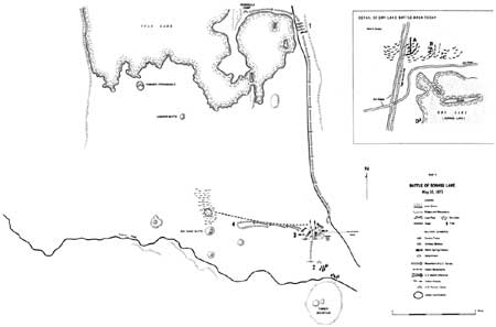
BATTLE OF SORASS LAKE

(click on image for an enlargement in a new window)
Map 8. Battle of Sorass Lake, May 10, 1873.
1. May 9, Captain Hasbrouck with Battery B, 4th Artillery, Troops B and G, 1st Cavalry, and Warm Springs marched from Peninsula Camp to Sorass (Dry) Lake. All units were mounted.
2. Battery B camped in timber one mile south of lake.
3. Hasbrouck and main command camped at the lake, which was dry. May 10, before dawn, Modocs attacked Hasbrouck from high ridge 400 yards north and lower ridge 200 yards north. Hasbrouck counterattacked, Troop B on right, one-half of Troop G on left, one-half of Warm Springs to left flank, other half of Warm Springs to right flank. Other half of Troop G assigned to collecting stampeding horses. Warm Springs' flanking movements failed to surround Modocs due to rapid retreat of latter. Troops drove Modocs to lava flows north of Big Sand Butte. Battery B arrived at lake from its camp too late to participate in chase. Only Warm Springs succeeded in getting mounted during fight.
4. Hasbrouck pursued Modocs 3-4 miles. Returned all the way north to Peninsula Camp because of lack of water.
Enlargement of Dry Lake
A. Higher ridge. Has natural cracks in lava, parts of which are suited for trench fighting; today there is one rock fortification.
B. Lower ridge. Today there is one rock fortification and two rock piles.
C. Two boundary markers.
D. Juniper tree and rock pile—traditional site of Hasbrouck's camp.
| <<< Previous | <<< Contents>>> | Next >>> |
thompson/map8.htm
Last Updated: 11-Nov-2002