|
Lava Beds
Modoc War Its Military History & Topography |

|
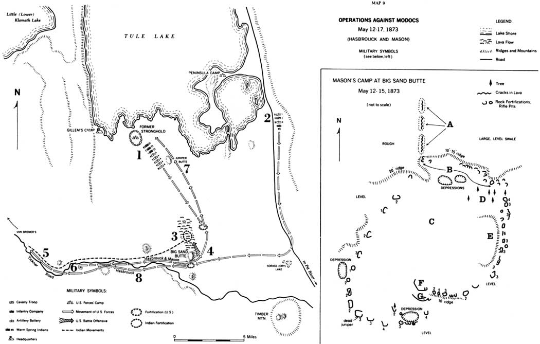
Map 9
OPERATIONS AGAINST MODOCS
(click on image for an enlargement in a new window)
Map 9. Operations Against Modocs, May 12-17, 1873.
1. May 12, Major Mason, with eight companies, marched from camp at Stronghold, through Lava Beds, to site north of Big Sand Butte and east of lava flows.
2. May 12, Captain Hasbrouck, with four companies, marched from Peninsula camp, via Sorass Lake, to site south of Big Sand Butte.
3. May 12, 3:30 p.m., Mason established that Modocs were camped in the lava flow north of Big Sand Butte. May 13 and 14, Mason and Hasbrouck made reconnaissance from Big Sand Butte and planned coordinated attack.
4. May 14, afternoon, Lieutenant Hazelton, with 26 volunteers from Hasbrouck's camp, patrolled into lava flow and determined that Modocs had fled.
5. Internal dissent caused Modocs to split, one group heading west on Tickner Road, other group disappearing temporarily.
6. May 15, Hasbrouck and Mason, unaware of Modocs' splitting, followed trail eight miles westward camps.
7. Mason led his command back to Stronghold camp via Juniper Butte.
8. May 16, Hasbrouck received horses from Peninsula camp and followed Modoc trail westward.
Mason's Camp
A. Three long lava ridges, total about 1500 feet, each ridge contains natural cracks suitable for defense. No evidence of reinforcement.
B. All fortifications on this north side are low, simple, rifle-pittypes. Each would hold 1-3 men, crouching or lying.
C. Area fortified is about 30 acres, generally level, grass and brush covered, slightly higher than surrounding country, about 1500 feet in diameter. It has not been surveyed. Numbers on fortifications indicate approximate height of outside walls. Disposition of Mason's 8 companies unknown; but different types of construction of forts reflect individuality of different companies.
D. Tree symbols indicate actual trees—total of 8.
E. Large swale, lower than area containing fortifications.
F. Rock wall, 40-50 feet long, 4 feet high.
G. Rock wall, 50 feet long, 5-6 feet high.
| <<< Previous | <<< Contents>>> | Next >>> |
thompson/map9.htm
Last Updated: 11-Nov-2002