|
NATIONAL PARK SERVICE
The Lewis and Clark Trail A Proposal for Development |

|
INTRODUCTION
A system of scenic and historic routes across the continent following the Lewis and Clark Trail was suggested many years ago. In 1948 the National Park Service recommended a "Lewis and Clark Tourway" to follow the Missouri River from St. Louis to Three Forks, Montana. The present study is the outgrowth of an idea of J. N. "Ding" Darling, the noted conservationist and cartoonist, who conceived the notion of preserving the historic sites and enhancing the wildlife and other recreation resources along the route of the Lewis and Clark Expedition. The Foundation established in Mr. Darling's name advanced this proposal to the Secretary of the Interior, Stewart L. Udall, who enthusiastically endorsed the concept of memorializing the Lewis and Clark Trail by creating a "recreation ribbon" along the cross-country route.
In 1962, Secretary Udall directed the Bureau of Outdoor Recreation to work with other Interior agencies and interested Federal departments and with the States and local governments to analyze the proposal and to formulate a plan of development which would recommend ways to identify, protect, develop, and interpret for the public benefit the historic, recreation, cultural, and scenic potential of the Expedition route.
Studies were made in all 10 States through which the Expedition passed from the confluence of the Missouri and Mississippi Rivers to the Pacific Ocean: Missouri, Kansas, Nebraska, Iowa, South Dakota, North Dakota, Montana, Idaho, Oregon, and Washington. Not only were the rivers and the immediate Expedition pathway studied, but also the lands bordering the route on each side for a distance varying from a few miles to about 25 miles.
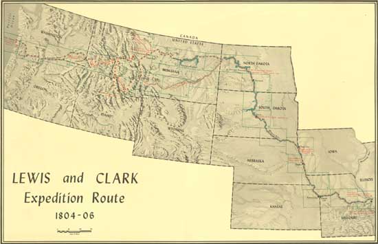
(click on map for a PDF version)
The preparation camp for the Lewis and Clark Expedition was located at the mouth of Wood River, on the east bank of the Mississippi River in what is now the State of Illinois. Although the Expedition route did not actually pass through Illinois, a brief review is included of the Expedition's activities while at Camp Wood and of the area as a recreation resource.
The story of the Lewis and Clark Expedition, the demand for recreation opportunities, the problems of providing the needed facilities, and the basic development program for the historic, wildlife, and other recreation resources along the Lewis and Clark Trail are presented in this report as they relate to the States lying along the Trail. Following this is an analysis by States containing more details on the Expedition, the recreation resources, and the recommended program. The report concludes with an inventory of existing and proposed recreation areas with maps showing the location of the areas, the route of the Expedition and campsites, and a proposed routing for a Lewis and Clark Trail Highway.
This report was prepared by the Bureau of Outdoor Recreation and has been reviewed by staff members of the State and Federal agencies involved. The recommended program is based on the findings of the report as interpreted by the Bureau of Outdoor Recreation.

| <<< Previous | <<< Contents>>> | Next >>> |
lecl/proposal-for-development/intro.htm
Last Updated: 11-Jun-2012