|
Mississippi National River and Recreation Area Minnesota |
|
 NPS photo | |
A Flowing Pageant of Life
From northern Minnesota to the Gulf of Mexico, the Mississippi River flows. It reminds us of the past, nurtures the present, and shapes the future. Hundreds of tributaries in 31 states, from the Rocky Mountains to the Appalachians, feed the river. It ripples with stories—of people and places from the great American pageant. The cast includes the Ojibwa and the Dakota, European explorers and fur traders, farmers and loggers, steamboaters and towboaters, factory workers and office clerks, engineers and teachers. Their lives and the river are intertwined.
Congress recognized the river's historic, ongoing role in molding the national character when it established the Mississippi National River and Recreation Area in 1988. Minneapolis and Saint Paul are at the center of this 72-mile stretch of the river. The park encompasses many public places managed by state or local agencies and organizations. These sites interpret the park's natural, cultural, economic, scientific, and historic resources and offer scenic and recreational opportunities from photography to boating.
Minneapolis traces its roots to European settlements at Saint Anthony Falls. The falls powered gristmills and sawmills that provided flour and lumber for settlers. Historically, Saint Paul was the northernmost navigable point on the more than 2,300-mile-long river. The early villages flourished, becoming transportation hubs and commercial centers. Today the Mississippi provides drinking water and hydropower for much of the metropolitan area and carries away treated wastewater. It continues to serve, as it has for thousands of years, as a transportation corridor.
A Center for Trade
American Indian tribes began moving into the upper Mississippi Valley about 12,000 years ago, after the last continental glacier's retreat. They built intermittent and seasonal villages on terraces above the riverbanks and canoed the waterways to hunt, gather plants, and trade goods.
European expeditions reached parts of the Mississippi River in the 1600s and 1700s. Some were searching for the river's mouth. Others were searching for its origin. They hoped that the river might provide a shortcut across the continent to the Far East—the rumored Northwest Passage.
Recognizing the region's vast natural riches, the French (late 1600s-1763) and English (1763-early 1800s) established trading posts along the upper Mississippi River and its tributaries, the Minnesota and Saint Croix rivers. At these posts they traded beaver pelts and other furs for cloth, metal tools, and more. Early settlers described the bounties of the wilderness and the opportunities they found to create new lives for themselves and their children.
In the mid-1800s Germans, Norwegians, Swedes, and other Europeans moved to the area, as did Americans from the East. By 1854 the Dakota had been forced onto reservations along the Minnesota River. The newcomers cleared forests, built homes, and constructed roads linking farms with villages and ports. In 1858 more than 1,000 steamboats docked at Saint Paul. Minneapolis harnessed the river's power, making it the nation's flour milling capital from 1880 to 1930.
Roads and other transportation systems fed the rapid growth of cities, towns, and suburbs in the 1900s. Water quality declined. Woodlands, grasslands, and wetlands, which had provided wildlife habitat, disappeared. Growing awareness led to establishing local, regional, state, and federal parks, refuges, recreational areas, and historic sites. Today, some of these are partners in the Mississippi National River and Recreation Area.
A Corridor for Wildlife
The park is home to many amphibians, reptiles, mammals, birds, and fish. Millions of birds migrate every fall and spring along the riverway, one of five major flyways in the United States. Migrants and resident species feed on the microorganisms and fish in rivers, streams, ponds, and wetlands.
Bald eagles soar over the river and snatch fish in their talons to feed their young waiting in treetops. Great blue herons and egrets leave rookeries along the river to stalk marsh edges for fish and frogs. Beavers dine on silver maples, cottonwoods, and willows while raccoons forage for nuts, berries, and insects. Floodplains and adjacent forests are also home to rabbits, foxes, deer, snakes, and salamanders. Mainstream and backwaters and channels of the Mississippi serve as nurseries for fish—tiny darters to shovelnose sturgeon. As snow falls, river otters' slide tracks and footprints lead toward open water. As the river flows it creates open patches in iced-over stretches, bringing benefits to many species.
The Mississippi National River and Recreation Area represents the rich natural, cultural, historic, scientific, economic, and recreational resources of the entire Mississippi River, known to the Ojibwa as the Mee-zee-see-bee (Father of Waters).
Partners in Protecting Your River
The 54,000-acre Mississippi National River and Recreation Area is a partnership park. The National Park Service owns very little of the park's land. It works with state agencies, 25 local governments, and many organizations to protect globally significant resources along the 72-mile-long stretch of river that runs through the Minneapolis/Saint Paul metropolitan area.
The Mississippi River's National Park
In 1988 Congress created this national park. It preserves, protects, and enhances important values of the waters and land of the Mississippi River corridor within the metropolitan area. The park extends from the communities of Dayton and Ramsey, to the north, to just south of Hastings.
About one-third of the park is open water. The land belongs to a mix of government agencies and private landowners—businesses, organizations, and individuals.
The National Park Service provides leadership. It facilitates, coordinates, and promotes a common vision for the river communities, partner agencies, and organizations whose responsibilities intersect.
Park staff work with hundreds of public and private partners to protect and manage the river. Projects range from comprehensive policy initiatives to targeted historic preservation, water quality improvement, and public trail building efforts.
The park offers interpretations of scientific data to the public, to promote understanding of how the river's health can impact recreational opportunities and wildlife.
Several partners have joined forces to develop and sponsor educational river trips for the public and for school groups. Volunteers, rangers, and partners work together to offer programs like Big River Journey, Journey to the Falls, Bike with a Ranger, Urban Wilderness Canoe Adventure, and Habitat Restoration events.
The Mississippi River Fund makes possible many of the park's efforts. It is the charitable, nonprofit partner of the Mississippi National River and Recreation Area. The fund supports programs to educate the public, encourage recreation, revitalize communities, and restore natural spaces. It also supports park efforts to enhance and expand programs that serve the public through outdoor and online activities, and encourage volunteerism.
For information about partnerships programs, contact the Mississippi River Visitor Center.
Towboats move up the Mississippi in Saint Paul. Founded as a riverboat landing, the city became the territorial capital in 1849.
Biking is an ideal way to experience the scenic Mississippi River trails.
At the once abandoned historic Coldwater Spring, between Historic Fort Snelling and Minnehaha Falls, the National Park Service has restored prairie and oak savanna.
Minnehaha was immortalized not only by poet Henry Longfellow but by this waterfall, creek, and regional park that bear the name in Minneapolis.
Crosscountry skiers glide through forested bottomlands along the Minnesota River at Fort Snelling State Park. The park also offers hiking and biking, plus programs and exhibits on the Dakota, geology, and life in woodlands, marshes, and meadows.
Coon Rapids Dam connects Anoka County Parks with Three River Park District to make a seamless park great for hiking, biking, fishing, and boating.
Visit Boom Island Park and enjoy spectacular views of the Minneapolis skyline from paved pedestrian and bicycle paths. A boat launch and paths connect Boom Island to other parks and other river experiences.
Learn about Minnesota's oldest European-American settlement at Sibley House Historic Site in Mendota. Tour two 1830s limestone houses. Listen to stories about Henry Hastings Sibley, Jean Baptiste Faribault, and the fur-trading center at the confluence of the Mississippi and Minnesota rivers.
Harriet Island, in Saint Paul's West Side, stages many summer events. Watch the activities on the river or fish from the docks. Board an excursion boat. The Science Museum of Minnesota, across the river, houses the Mississippi River Visitor Center.
Backwater sanctuaries provide unique aquatic environments. Rejuvenated by periodic flooding, these places supply nutrients for plants, aquatic organisms, and birds. Pickerel and Crosby lakes in Saint Paul are known for dragonflies and river otters, Mooers Lake for flowering lotus and long-nose gar.
Stone Arch Bridge is a National Engineering Landmark and part of the Saint Anthony Falls Heritage Trail. It offers pedestrians, bicyclists, and joggers magnificent views of the falls. Waterpower from the falls made Minneapolis the nation's milling capital from 1880 to 1930.
Bald eagles can be seen year-round along the 72-mile corridor. Their numbers continue to rise as water quality improves. In winter look for eagles near patches of open water.
Long a working river, the Mississippi River moves towboats and barges between the Twin Cities and Saint Louis or New Orleans. Goods heading south include grain, coal, oil, and gravel. The US Army Corps of Engineers operates the dams and locks.
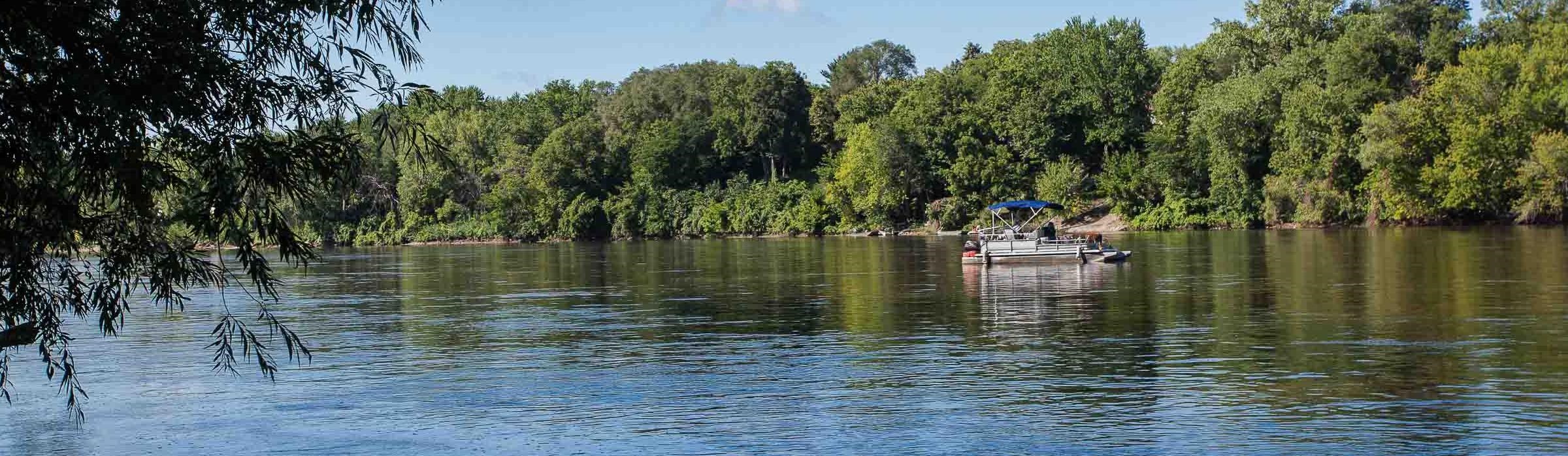
The river is a popular place for boating and offers a surprisingly wild experience in the heart of the Twin Cities.
Take a river excursion to sense the Mississippi's role in daily life in the Twin Cities. Sternwheelers and other boats depart from Bohemian Flats Park in Minneapolis and Harriet Island in Saint Paul.
With improved water quality and habitat, the Mississippi is once again a world-class fishery.
View the Mississippi River from the vantage point of the old Rock Island Swing Bridge, now a pedestrian pier. Swing and lift bridges help move river, automobile, and train traffic.
River Destinations
Coon Rapids Dam Regional Park East - Anoka County - 9750 Egret Blvd., Coon Rapids West - Three Rivers Park District - 10360 W River Rd. Brooklyn Park |
Fees. Visitor centers, programs, exhibits, boat and
canoe launch, fishing, hiking, biking, crosscountry
ski trail, equipment rental, picnic area, and shelter |
North Mississippi Regional Park Minneapolis Park and Recreation Board 5114 N. Mississippi Dr. Three Rivers Park District - 4900 Mississippi Ct. |
Visitor center, programs, exhibits, canoe launch,
fishing, biking, crosscountry ski trail, playground,
wading pool, picnic shelter |
Minneapolis Riverfront District 103 Portland Ave. S., Minneapolis |
Encompassing several riverfront parks and the Stone
Arch Bridge. Boat launch, fishing, hiking, biking |
Mill City Museum 704 S. 2nd St, Minneapolis |
Fees. Interactive exhibits, water lab, flour tower
ride, programs, rooftop observation deck |
Locks and Dams Saint Anthony Falls 1 Portland Ave., Minneapolis Lock and Dam No. 1 5000 W. River Pkwy, Minneapolis Lock and Dam No. 2 1350 Dam Rd., Hastings |
Exhibits, observation decks, restrooms |
Minnehaha Regional Park 4801 S. Minnehaha Park Dr., Minneapolis |
Hiking, biking, playground, picnic area and shelter |
Coldwater Spring 5601 S. Minnehaha Park Dr., Minneapolis |
Hiking through restored oak savanna prairie,
visiting historic Coldwater Spring |
Historic Fort Snelling 200 Tower Ave., Saint Paul |
Fees. Visitor center, programs, exhibits, living history
demonstrations |
Fort Snelling State Park 101 Fort Snelling State TrL, Saint Paul |
Fees. Visitor center, programs, exhibits, boat launch,
fishing, hiking, biking, crosscountry ski trail |
Sibley House Historic Site 1357 Sibley Memorial Hwy., Mendota |
Fees. Visitor center, historic structures from fur trade
era, interpretive programs and exhibits |
Hidden Falls and Crosby Farm Regional Park City of Saint Paul Parks and Rec. Hidden Falls - 1313 Hidden Falls Dr. Crosby Farm - 2595 Crosby Farm Rd. |
Boat and canoe launch, fishing, hiking, biking,
crosscountry ski trail, picnic area and shelter |
Lilydale-Harriet Island-Cherokee Regional Park City of Saint Paul Parks and Rec. Lilydale - 950 Lilydale Rd. Harriet Island - 200 Dr. Justus Ohage Blvd. Cherokee - 700 Cherokee Hts. Blvd. |
Boat and canoe launch, fishing, hiking, biking,
crosscountry ski trail, picnic area and shelter |
Mississippi River Visitor Center 120 Kellogg Blvd. W., Saint Paul |
Park rangers, programs, exhibits, trip-planning
station |
Science Museum of Minnesota 120 Kellogg Blvd. W., Saint Paul |
Fees. Mississippi River Gallery and Towboat Terrace,
interactive exhibits, programs, Omnitheater |
Indian Mounds Park-Bruce Vento Nature Sanctuary City of Saint Paul Parks and Rec. Indian Mounds - 10 Mounds Blvd. Bruce Vento - E. 4th & Commercial Sts. |
Exhibits, hiking, self-guiding trail, biking, picnic area
and shelter |
Schaars Bluff-Spring Lake Park Reserve 8395 127th St. E., Hastings |
Visitor center, hiking, crosscountry ski trail, archery
trail, playground, picnic area and shelter |
Great River Road Learning Center and Freedom Park 200 Monroe St., Prescott, WI |
Visitor center, programs, picnic area and shelter,
playground |
River Recreation Contacts
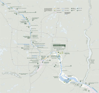 (click for larger map) |
Watercraft and Fishing All watercraft (boats, canoes, kayaks, etc.) operators are responsible for watercraft licenses and following Minnesota watercraft regulations within the park. All persons fishing in the park are responsible for obtaining appropriate fishing license and following Minnesota fishing regulations. River conditions vary considerably throughout the park. Beginning in Minneapolis, the US Army Corps of Engineers maintains a nine-footdeep navigation channel, and recreational watercraft share the river with barges. Barges turn slowly, throw large wakes, and have the right-of-way. Stay clear and pass on the inside of bends.
For river maps and guides:
Mississippi River Visitor Center
For watercraft and fishing licensure and regulations:
Minnesota Department of Natural Resources
www.dnr.state.mn.us
Biking and Hiking Trails for biking and hiking offer many opportunities to experience the Mississippi River's many facets. Check out the Mississippi River Trail (MRT), a bikeway from the river's headwaters to the Gulf of Mexico. For information about bike share programs in the park and for a detailed guide to trails along the river:
Mississippi River Visitor Center
Mississippi River Trail
www.mississippirivertrail.org
Locks and Dams Four locks and dams within the park are maintained by the US Army Corps of Engineers. Visitors can view the locks and dams from exterior overlooks with educational panels. For the current locks and dams schedule, a brochure about the lock and dam system, or to buy a copy of the Upper Mississippi River Navigational Charts:
US Army Corps of Engineers
www.mvp.usace.army.mil
Camping and Accommodations There are no campgrounds within the park. To find camping and other accommodations in the metropolitan area:
Minnesota Office of Tourism
www.exploreminnesota.com
Scenic Drives Scenic views of the river are provided throughout the park. Portions of the Grand Rounds and Great River Road (GRR) National Scenic Byways are in the park. For more information on the GRR, the byway from the headwaters of the Missisippi River to the Gulf of Mexico:
Mississippi River Parkway Commission of Minnesota
www.mnmississippiriver.com
Other Information
Facilities and Land Ownership Of nearly 54,000 acres in the Mississippi National River and Recreation Area, the National Park Service owns less than 100 acres. Some land within the park and along the riverbanks is privately owned. Please respect landowners and do not disturb them or their property.
Headquarters Park headquarters are open Monday to
Friday, with limited information services.
111 East Kellogg Blvd., Suite 105
Saint Paul, MN 55101
www.nps.gov/miss
Park Land The National Park Service owns nine islands in the Mississippi River and Coldwater Spring, a 29-acre public park.
Visitor Center The Mississippi River Visitor Center, in the lobby of the Science Museum of Minnesota, offers exhibits, programs, and trip-planning help.
Accessibility We strive to make our facilities, services, and programs accessible to all. For information go to a visitor center, ask a ranger, call, or check our website.
Fees For fee information for sites not managed by the National Park System, please contact the land managing organization (see River Destinations, left). Firearms For firearms regulations check the park website.
Federal Pass Program Obtain National Parks and Federal Recreational Lands passes (annual, senior, access) at the Mississippi River Visitor Center.
Cooperating Visitor Centers and National Park Passport Stamp Several visitor centers offer exhibits and programs interpreting the human and natural history of the Mississippi River area. Get your Your National Parks Passport stamped at many sites. Obtain your primary stamp and a complete list of stamp locations within the park at the Mississippi River Visitor Center.
Mississippi River Fund The Mississippi River Fund is the charitable, nonprofit partner of the Mississippi National River and Recreation Area. For more information about the work the fund does to support the park and/or to donate to the fund:
Mississippi River Fund
111 Kellogg Blvd. E., Suite 105
Saint Paul, MN 55101
www.missriverfund.org
Source: NPS Brochure (2015)
|
Establishment Mississippi National River and Recreation Area — November 18, 1988 |
For More Information Please Visit The  OFFICIAL NPS WEBSITE |
Documents
Acoustic Amphibian Monitoring, 2019 Data Summary: Mississippi National River and Recreation Area NPS Natural Resource Data Series NPS/GLKN/NRDS-2022-1378 (Gary S. Casper, Stefanie M. Nadeau and Thomas B. Parr, December 2022)
Acoustic Monitoring for Bats at Mississippi National River and Recreation Area: Data Summary Report, 2016–2019 NPS Natural Resource Data Series NPS/GLKN/NRDS—2021/1322 (Katy R. Goodwin and Alan A. Kirschbaum, April 2021)
Aquatic Studies in National Parks of the Upper Great Lakes States: Past Efforts and Future Directions NPS Technical Report NPS/NRWRD/NRTR-2005/334 (Brenda Moraska Lafrancois and Jay Glase, July 2005)
Bat Monitoring Protocol for the Great Lakes Inventory and Monitoring Network — Version 1.0 (NPS Natural Resource Report NPS/GLKN/NRR-2020/2126 (Katy G. Goodwin, May 2020)
Confluence Area Shuttle Plan: Mississippi National River and Recreation Area (March 2015
Contaminants in Bald Eagle Nestlings at Apostle Islands Lakeshore, Mississippi National River and Recreation Area, and the St. Croix National Scenic Riverway: Data Summary, 2006-2008 NPS Natural Resource Data Series NPS/GLKN/NRDS-2009/001 (Bill Route and Rebecca Key, June 2009)
Final Comprehensive Management Plan Environmental Impact Statement Volume Two: Mississippi National River and Recreation Area (October 1994)
First Came the River (2004)
Forest Health Monitoring at Mississippi National River and Recreation Area NPS Natural Resource Data Series NPS/GLKN/NRDS-2023/1400 (Suzanne Sanders and Jessica Kirschbaum, November 2023)
Foundation Document, Mississippi National River and Recreation Area, Minnesota (April 2014)
Foundation Document Overview, Mississippi National River and Recreation Area, Minnesota (April 2014)
Historical Study, Former U.S. Bureau of Mines Property, Twin Cities Research Center Final Report (Barbara J. Henning, October 2002)
Implementation of a Long-term Vegetation Monitoring Program at the Mississippi National River and Recreation Area NPS Natural Resource Technical Report NPS/GLKN/NRTR-2012/616 (Suzanne Sanders and Jessica Grochowski, August 2012)
Junior Ranger Program, Mississippi National River and Recreation Area (Date Unknown; for reference purposes only)
Landsat-based Monitoring of Landscape Dynamics at Mississippi National River and Recreation Area: 2005-2010 NPS Natural Resource Technical Report NPS/GLKN/NRTR-2013/745 (Alan A. Kirschbaum and Ulf B. Gafvert, May 2013)
Mississippi Park Connection Annual Reports: 2014-2015 • 2015-2016 • 2016-2017 • 2017-2018 • 2018-2019 • 2019-2020 • 2020-2021 • 2021-2022 • 2023
Mississippi River Corridor Study — Volume 1: Feasibility Report (May 1996)
Mississippi River Corridor Study — Volume 1: Inventory of Resources and Significance (May 1996)
Mississippi River Fund Annual Reports: 2007-2008 • 2008-2009 • 2009-2010 • 2010-2011 • 2011-2012 • 2012-2013 • 2013-2014
Mississippi River News
Fall-Winter: 2014-2015 • 2015-2016 • 2016-2017 • 2017-2018 • 2018-2019 • 2019-2020 • 2020-2021 • 2021-2022
Spring-Summer: 2015 • 2016 • 2017 • 2018 • 2019 • 2020 • 2021
Mussel (Bivalvia: Unionidae) Survey of the Mississippi National River and Recreation Area Corridor, 2000-2001 NPS Natural Resource Technical Report NPS/GLKN/NRTR-2008/137 (Dan Kelner and Mike Davis, November 2008)
Natural Resource Condition Assessment, Mississippi National River and Recreation Area NPS Natural Resource Report NPS/MISS/NRR-2015/990 (George J. Kraft, Christine Mechenich, David J. Mechenich, James E. Cook and Jennifer L. McNelly, July 2015)
Parkway for the Mississippi: The River, The Project, The Plan (1952)
Partnerships for the Future of the Metropolitan Mississippi Corridor: Mississippi National River and Recreation Area (August 1996)
Proposed Upper Mississippi River National Park (Roger W. Toll, October 8, 1931)
River of History: A Historic Resource Study of the Mississippi National River and Recreation Area (John O. Anfinson, 2003)
Shuttle Market Analysis: Mississippi National River and Recreation Area (May 2015)
Songbird Monitoring in the Great Lakes Network Parks: 2014-2018 NPS Natural Resource Report NPS/GLKN/NRR-2021/2217 (Samuel G. Roberts, Zachary S. Ladin, Elizabeth L. Tymkiw, W. Gregory Shriver and Ted Gostomski, January 2021)
State of the Park Report, Mississippi National River and Recreation Area, Minnesota State of the Park Series No. 4 (April 2013)
"Stories of the Delta": Lower Mississippi Delta Symposium, June 4, 5 & 6, 1996 (Shapins Associates, Inc. and Sylvia Angell Written Communications, 1996)
The Cultural Meaning of Coldwater Spring: Final Ethnographic Resources Study of the Former U.S. Bureau of Mines Twin Cities Research Center Property, Hennepin County, Minnesota Final Report (Summit Envirosolutions, Inc. and Two Pines Resource Group LLC, June 2006)
The Mississippi National River and Recreation Area Study — Report I: Summary of Findings (David W. Lime, Christine J. Clements, Jonathan Vlaming and Timothy D. Schleicher, June 1992)
The Mississippi National River and Recreation Area Study — Report II: Respondent Comments (David W. Lime, Christine J. Clements, Jonathan Vlaming and Timothy D. Schleicher, June 1992)
The Mississippi National River and Recreation Area Study — Report III: Detailed Analyses (Christine J. Clements, David W. Lime and Wayne Freimund, August 1992)
The Secret History of the Earliest Locks and Dams (John O. Anfinson, extract from Minnesota History, Summer 1995)
Vegetation Inventory Program: Mississippi National River and Recreation Area, Minnesota NPS Natural Resource Report NPS/GLKN/NRR-2015/1002 (Kevin Hop, Jim Drake, Andrew Strassman, Erin Hoy, Joe Jakusz, Shannon Menard and Jennifer Dieck, August 2015)
Water Quality Conditions and Trends in the Mississippi National River and Recreation Area: 1976-2005 NPS Natural Resource Technical Report NPS/GLKN/NRTR-2013/691 (Brenda Moraska Lafrancois, Suzanne Magdalene, D. Kent Johnson, David VanderMeulen and Daniel Engstrom, February 2013)
Water Quality Monitoring at Mississippi National River and Recreation Area: 2012 Summary Report NPS Natural Resource Data Series NPS/GLKN/NRDS-2013/577 (David VanderMeulen, November 2013)
Water Resources Information and Issues Overview Report: Mississippi National River and Recreation Area NPS Natural Resource Report NPS/NRWRD/NRTR-2007/364 (Brenda Moraska Lafrancois, David L. Vana-Miller and Steven P. Johnson, March 2007)
miss/index.htm
Last Updated: 01-Jan-2025