|
Mojave
From Neglected Space To Protected Place: An Administrative History of Mojave National Preserve |

|
CHAPTER SEVEN:
VISITOR SERVICES
Much of the management of Mojave National Preserve takes place out of the direct public eye. Park visitors see only the tip of the employee iceberg. Those rangers who do directly interact with park patrons generally come from two of the Preserve's administrative divisions. Some are law enforcement rangers, in charge of protecting park visitors and the resources of the Preserve. Others are interpretive rangers, responsible for educating the public about Mojave National Preserve. Both law enforcement rangers and interpretive personnel are common to nearly all NPS units, but both job types at Mojave National Preserve have unusual features because of the size of the park and its proximity to urban areas.
After the Dollar Budget threat passed, one of the first priorities for the park was establishment of a ranger program. The departure of Bill Blake and the seasonal rangers left the Preserve virtually unprotected. Sean McGuinness was stationed at Wrangell-St. Elias National Park and Preserve before being chosen as Mojave's Chief Ranger. Upon his arrival, he was placed in charge of all visitor services. The management team allocated money for three law enforcement rangers and two more interpretive rangers to assist Kirsten Talken. As Mojave National Preserve tried to reinvigorate a dormant ranger program, the law enforcement and interpretive challenges seemed daunting. [271]
Resource and Visitor Protection
At Mojave National Preserve, the challenges posed both by urban growth in the Southwest and by the compromises inherent in the park's formation fall squarely on the shoulders of the law enforcement ranger corps. Mojave is a "nowhere between two somewheres," and it is these "somewheres" — specifically the greater Los Angeles and Las Vegas metropolitan areas — that contribute to most of the workload for Mojave's law enforcement rangers. Speeding motorists, clandestine drug labs, graffiti, and theft and damage of natural resources result from Mojave's urban proximity. Other incidents have resulted from the railroads and freeways that run through and adjacent to park lands, connecting the sprawling urban areas. Citizen attitudes toward the desert ecosystem of Mojave National Preserve complicate management even further. Many Americans viewed the desert as a wasteland, a mindset that did little to discourage illegal OHV use and illegal dumping. The history of low-key BLM management left its own legacy, further complicating the job of Mojave's rangers. Perhaps the biggest challenge of all was posed by the park's vast size - precisely how does one effectively patrol a 1.6 million acre park with only a handful of rangers?
Situated between two interstate freeways and between two major metropolitan areas, Mojave National Preserve endures a tremendous amount of road traffic that uses paved park roads as shortcuts. Much of this traffic travels between the Palm Springs and Twentynine Palms areas and Las Vegas. These visitors usually speed through the park, typically along Kelbaker and Kelso-Cima roads. Half of Mojave's ranger vehicles are outfitted with radar, and rangers watch carefully for violators as they patrol the park. Despite the fact that Mojave's posted speed limit of 55 miles per hour permits travel through Mojave faster than in most national parks, some visitors have been clocked at speeds half again as fast. In a typical example, Ranger Tim Duncan issued three tickets to motorists traveling 87mph, 70mph, and 80mph within a period of two hours on a single day in November 2001. Speeds in excess of 90mph are periodically detected. [272] Rangers also issue tickets for other typical traffic violations, such as accidents and disregarded stop signs, as well as more park-related violations such as "travel off a designated route." [273] The heavy emphasis that rangers at Mojave National Preserve must place on traffic stops and other sorts of work more typical of police forces in order to ensure public safety highlights the challenge posed to the ranger corps by Mojave's urban proximity. [274]
One of the most dangerous consequences of Mojave's nearness to urban areas is the use of the park by illegal narcotics manufacturers and drug dealers. Manufacture of illegal methamphetamine, often referred to as "crystal meth," has posed a considerable problem to the park. Meth is a synthetic drug, and the manufacturing process emits strong odors, which make labs easily detectable in urban areas. Abandoned sites in rural areas with little supervision but easy access to urban markets pose ideal conditions for methamphetamine manufacturers. Mojave's abandoned mine sites contain buildings and debris, which help meth manufacturers hide evidence of their activities. People associated with illegal drugs are usually heavily armed, and pose a substantial threat to the personal safety of law enforcement rangers or park visitors who come into contact with them.
On three separate occasions in October and November 1999, Ranger Sean Isham discovered large cardboard boxes with empty pseudoephedrine bottles. Twice these were found near the junction of Nipton Road and I-15, and once along a primitive road on the south side of Clark Mountain. Some human hairs were taken from the boxes as evidence. The presence of empty bulk pseudoephedrine containers suggests the presence of meth labs in the area, as over-the-counter pseudoephedrine can be cooked into crystal meth. [275]
Even more problematic than the use of abandoned mine sites by drug producers is the potential for mobile meth labs in the Preserve. In April 2001, an NPS ranger contacted a confidential informant who had observed on several occasions a suspected mobile methamphetamine lab, contained in an old Ryder truck. The informant also made note of the unsavory types that were associated with the truck, and pointed out that they had motorcycles and were heavily armed, with shotguns, rifles, and perhaps handguns as well. The same informant had seen what might have been a nighttime landing at the Lanfair airstrip, and overheard discussions about "tak[ing] a load to Las Vegas." The NPS ranger investigated the airstrip and found tire tracks, several weeks old, including some that might have come from a light plane. Clearly, the possibility of drug trafficking and methamphetamine manufacturing provides an edge of danger to park employees and visitors. [276]
Park rangers routinely patrol abandoned sites that might be attractive for drug producers, and have discovered several methamphetamine labs as a result. In February 1998, rangers on patrol found activity at Rainbow Wells that looked like a drug lab. Mojave received help from Death Valley NP and the Drug Enforcement Agency in setting up surveillance of the site. Some two weeks later, authorities raided the site early in the morning and caught Eric Wilson and Timothy Matthews in the act of producing crystal meth. The agents seized an arsenal of weapons as well as methamphetamine worth $75,000. Convicted in federal court, Wilson received a nine-and-one- half-year sentence, while Matthews waits out a twenty year sentence, neither with the possibility of parole. [277]
|
| Illustration 15 - NPS Rangers caught two suspects manufacturing methamphetamine in these buildings at the New Trail Mine. (Photo by Eric Nystrom, 2001.) |
In February 2001, Rangers Kirk Gebicke and Chris Jefferson noticed new locks on buildings at the New Trail Mine during a routine patrol of the area. The next day, as snow began to fall, Gebicke and Tim Duncan went to saw off the locks, and met four men in a pickup truck leaving the New Trail Mine. The rangers searched their vehicle, but found only camping equipment. The suspects also yielded a key that fit the padlocks the quartet had installed on mine buildings. The rangers proceeded to the mine, where they found considerable evidence suggesting the presence of an illegal drug lab at the site. NPS rangers guarded the area until the arrival of county drug task force members the following day. A subsequent search of the area revealed a considerable amount of drug-making equipment and ten gallons of pure methamphetamine oil, valued at more than $50,000, ready to be converted into the drug's final crystalline form. The area cost $20,000 to clean up, and in 2002, the case remained under adjudication. [278]
Vandalism and damage of park resources occurs with alarming frequency in the desert. Vandals deface or steal prehistoric rock art, shoot wildlife, buildings and signs, and sometimes burn historic structures to the ground. Unintentional damage due to negligence also causes problems. The Park Service can use a recent statute, known correctly as the "Park System Resources Protection Act" and informally as "19jj" after its U.S. Code section number, to recover money to repair park resources damaged by individual or collective action. The 19jj statute has been used at Mojave National Preserve to exact damages for wilderness road violations, resource damage due to airplane crashes, and all other incidents of deliberate or unintentional damage to park resources. [279]
Petty vandalism, conducted by parties unknown for no apparent reason, makes up the bulk of deliberate damage to park resources, but the park has to handle deliberate destruction of the environment for economic gain as well. In 1999, a company constructed a microwave tower just south of I-40, but required access to the site over park roads. After appropriate compliance documents were completed, the Park Service issued a special use permit, but stipulated that "no heavy commercial trucks, conveyances, or related construction equipment" was allowed, and that no improvements, such as blading, were permitted on the access road. In September 2000, park rangers noticed that the road had been bladed and widened several feet, which prompted the park to revoke the special use permit. The company did not admit wrongdoing at first and battled NPS and BLM attempts to exact restitution and cancel the project, but the DOI agencies prevailed in mid-2002. [280] In late July and early August 2001, a telephone company widened and graded more than three miles of road along a right of way to a microwave tower in the park, and built a new building at the site without NPS clearance. More than one mile of this road was a cherry stem into a designated wilderness area, and located in critical desert tortoise habitat. The Park Service is seeking compensation for the damages under 19jj. [281]
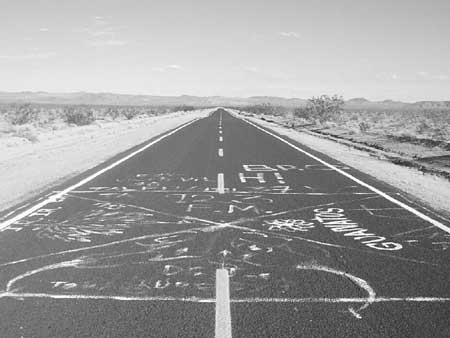
Mojave National Preserve has had to battle what is traditionally an urban problem - graffiti. Some visitors are amused by the spray-painted graffiti in the middle of Kelbaker Road south of Baker. In 2002, Ranger Bob Conway apprehended four suspects shortly after they allegedly used blue spray paint to cover some boulders with graffiti inside the Preserve. In cases such as these, the Park Service again can use the 19jj statute to get restitution for the full cost of the damages.
|
| Illustration 16 - Mojave National Preserve has to face typically urban problems such as this graffiti on Kelbaker Road. (Photo by Eric Nystrom, 2001.) |
Like many large parks, the Preserve has faced environmental damage resulting from the crash of a small airplane and the subsequent search and salvage operation. On March 8, 2000, a Piper Supercub flying from Las Vegas to Chino, California, was reported missing. The pilot, Robert Bogle, was the only occupant, and was last seen by a companion aircraft near Primm, Nevada. San Bernardino County Sheriffs, the Civil Air Patrol, and the California Highway Patrol searched for the missing plane and found it in the Ivanpah Valley, about 3 miles inside park boundaries. The next day, the plane wreckage was investigated by the sheriff's office, the county coroner, and the National Transportation Safety Board in helicopters and ground vehicles. The pilot's body was recovered, and on March 13 a salvage company hauled away what was left of the plane. During the recovery efforts, three helicopters landed at the site, and at least two vehicles drove straight to the site from Morning Star Mine Road, a distance of more than a quarter of a mile.
At the crash site, on a gently sloping bajada near the Morning Star Mine, there was a small burn and debris field, measuring only 75 feet by 39 feet. The crash burned 4 yuccas, 3 small barrel cacti, and two large creosote bushes. Some hydrocarbons and traces of heavy metals contaminated the soil, but did not extend down farther than about one foot. During the recovery/salvage process, vehicles drove over many plants, although reports indicate that the drivers may have tried to miss the biggest ones. There was no apparent wildlife damage, although the area is designated critical habitat for the desert tortoise. Total cost of replacement of the plants damaged was $4,760, and the projected total costs of the operation to restore the area, including minor landscape recontouring and administrative time, was $24,691.45. The NPS decided to pursue a claim under 19jj for the amount from the insurer of the airplane, but as of this time the claim is still under adjudication. The Ivanpah airplane crash highlights the appropriate use of the 19jj statute by the Preserve to receive compensation for all damages to park resources, no matter how noble the cause may have been. [228]
|
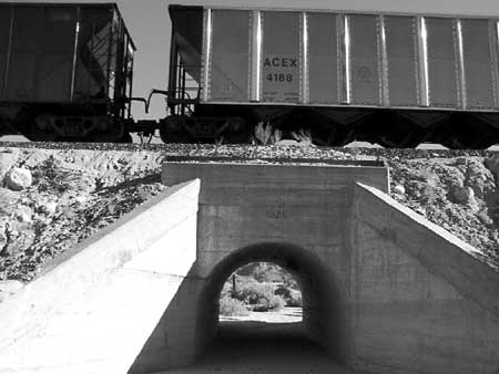
| Illustration 17 - The Union Pacific Railroad bisects Mojave National Preserve and creates unusual challenges for park rangers. (Photo by Eric Nystrom, 2002.) |
The Union Pacific Railroad (UP) bisects the Preserve, and brings special challenges to law enforcement rangers. The railroad is a target for vandals, and after the terrorist attacks of September 11, 2001, rangers paid even closer attention to any unusual activity near the railroad. Park rangers assist railroad police with any problems they might have along the Preserve portion of the UP line, and railroad personnel reciprocate by informing the rangers about any suspicious activity they might see. This positive, though informal, working relationship caused NPS rangers to assist railroad police apprehend thieves in the park. Burglars frequently boarded freight trains in the UP yards at Yermo, and broke into shipping containers while the train was moving. When the heavy freights slowed as they ascended the Cima grade, the bandits threw merchandise from the train. Accomplices collected it, loaded the contraband into waiting trucks, and hauled it away. The railroad lost more than one million dollars a month at one point from this kind of theft, but heavy enforcement by UP police and park rangers put a stop to the practice.
Rangers also have to worry about the railroad as a catalyst for other problems. On March 4, 2001 park personnel responded to a fire blazing in a pile of debris near the tracks. Footprints at the site suggested that the fire was deliberately set, and that the perpetrator escaped by jumping on a train climbing the hill. [283] This incident stands as an illustration of how the presence of the railroad can encourage undesirable activity in the park.
The trains themselves pose a hazard to the Preserve. Shortly before noon on January 12, 1997, Union Pacific westbound freight train #6205 lost control coming down the Cima grade and overturned at the Hayden siding. Trains ordinarily utilize engine braking to keep speeds below 20 miles per hour coming down the hill, but this time the engineer accidentally shut off the diesels. Air brakes, ordinarily sufficient to stop such a train on a normal grade, did little to slow the three locomotives and seventy five hopper cars full of bulk corn on the steep hill. The train reached 72 miles per hour just before sixty eight of the train's cars derailed and spilled their contents along the tracks. Ranger Brian Willbond described the scene as "a fantastic pile of rubble fifty feet high, with metal and corn everywhere." The railroad hired a salvage company to clean up the mess, but some loose corn was left behind, leading park personnel to worry about the effect of the increased food supply on the raven population. The wreck also suggested how much worse things could have been. "Tank cars are designed to survive a crash, unlike those boxcars," Ranger Tim Duncan observed, "but that doesn't mean they would." In the wake of the crash, the National Transportation Safety Board highlighted the danger that the super-steep downhill grade at Cima posed to heavy modern trains. In the event of a failure of the engine braking system on a train, the engineer has very little time to apply the air brakes before the train picks up so much speed that it cannot be stopped. The incidents prompted the railroad to make procedural changes to hopefully give train engineers more time to stop if an engine failure occurs, but the potential for future problems remains along Cima Hill because of the steep track slope. [284]
Mojave National Preserve sits between Interstate 40 and Interstate 15, a circumstance of geography that has direct and indirect implications for the park. The NPS has mutual-aid agreements with the San Bernardino County Sheriff, the BLM, and local fire and emergency medical service agencies. Park personnel response to highway incidents pose a substantial drain on NPS resources, although the relationship also benefits the park when emergencies occur inside its boundaries. Cargo traffic on the freeways poses a potential threat to the park's landscape. If a vehicle drove off of the right shoulder of northbound I-15 or westbound I-40, the damage would be within park territory. So far, however, no incidents of damage to park lands have taken place in this fashion.
Easy freeway access was an indirect catalyst for one of the most significant crimes Mojave law enforcement rangers have faced to date. From April to August 1995, Gene LeFave and his son, Louis LeFave, dumped ninety-seven drums of hazardous waste in the desert on NPS, BLM, and privately-owned land, rather than pay the $1,000 per barrel cost for legal disposal. Under cover of darkness, the LeFaves brought 55 gallon drums of waste products, including solvents, rubber, and adhesive glues, from their Las Vegas-based epoxy manufacturing business to a series of sites off Nipton Road, and pushed the barrels out of trucks onto the ground, where some split open. Most of the six sites used by the LeFaves in Mojave National Preserve were in washes, where the waste could have contaminated water supplies. Some small wildlife was found dead, stuck in the residue, by CDF&G officials. An interagency team, including federal and state law enforcement officials, apprehended Louis LeFave and a seventeen year old boy in the process of dumping more waste. In federal court, Louis LeFave was fined $40,000 and sentenced to two and one-half years in prison, while his father, Gene LeFave, was fined the same amount and sentenced to almost four years in jail. The Park Service and BLM spent more than $170,000 cleaning up the dump sites. Chief Ranger Bill Blake, Martin, and Ranger Eric Inman later accepted the DOI Secretary's Award on behalf of Mojave National Preserve for the park's role in the investigation and prosecution of the dumping case. [285]
"Operation Sweet Success" may prove to be just as momentous. Since at least the mid-1980s, an organized group of Hispanic workers have illegally collected barrel cacti from federal lands in the desert, including Mojave National Preserve lands near Nipton. These cacti were cut into pieces and sold to two competing companies in the Los Angeles area, where they were made into biznaga, a form of cactus candy popular in Mexico. A Department of the Interior special investigator was in charge of the case against the cactus poachers, and was assisted by personnel from several agencies, including Mojave National Preserve. Ranger Tim Duncan participated in raids on the candy facilities in December 1999, and had earlier helped detain suspects found harvesting cacti on BLM land near Clark Mountain. Agents in charge of the case estimate that some 15,000 mature barrel cacti were removed from federal lands in the desert at the behest of the cactus poachers, who knew their activity was illegal but bragged that they could not be touched because of powerful and influential friends. At a replacement cost of $50-$200 per cactus, depending on size, the final cost in environmental damage alone will be substantial. The case is still in adjudication, but the Park Service intends to seek restitution under the 19jj statute for damage to park resources. [286]
A history of less restrictive management of the desert the BLM posed special challenges to park rangers once the lands transferred to Park Service control. A substantial problem has been posed by off-road vehicle and all-terrain vehicle users in the park. Some off-road users, such as careful four-wheel drive groups, impact the desert only lightly and take pains to minimize ecological damage. Other all-terrain vehicle users, especially some motorcycle riders, have caused great damage in parts of the California desert by riding aggressively across undisturbed land. The BLM acknowledged this fact in the 1980 Desert Plan by setting aside small portions of the desert as "open play" areas for OHVs, and setting other areas aside as off limits to off-roaders. Most of the area that became Mojave National Preserve was open to use by off-highway vehicles, as long as the machines had a "green sticker" and stayed on established trails or in washes. NPS policy permitted only street-legal vehicles to operate in the park, thus excluding a large number of motorcycles, ATVs, and dune buggies. Nonetheless, ATV use in the park continues, albeit at far lower levels than before. In November 1999, Ranger Sean Isham issued four citations for ATV use in the park in less than one week. The OHV problem is compounded by the CDPA's decision to establish the park's western boundary, a wilderness area, adjacent to BLM's Rasor open play area. As a result, vehicles often stray, accidentally or otherwise, from the open area into the Preserve's Soda Lake wilderness. Thanksgiving weekend traditionally saw heavy use of the play area by OHV users. Mojave responded by bringing in SET teams of rangers from other parks to patrol the boundary. The first SET team secured the area in 1994, and others did so in succeeding years, although the problem diminished in severity as users were educated about the regulations. In a typical example, five rangers from Lake Mead NRA patrolled the area during the 1999 holiday weekend, while Mojave's full ranger force monitored the rest of the park. The SET team issued five citations and many warnings to errant OHV users. [287]
Sometimes ATV use causes other problems. In November 2000, two boys, 11 and 14 years of age, were riding ATVs on private land near Fourth of July Canyon. They collided and were both seriously injured, suffering broken bones, a dislocated hip, and possible spinal injuries as well. NPS rangers were the first to arrive on scene, and stabilized the victims for over 20 minutes until medical personnel could arrive. The two were both flown by air ambulance to Las Vegas hospitals. The large distance from the Preserve to the nearest medical care in Las Vegas means that NPS first responders bear substantial responsibility for initial medical care in case of emergencies in the park. [288]
Desert users acting according to local custom and less restrictive BLM rules occasionally found themselves in violation of NPS regulations against firearms. Under BLM, firearms were allowed in the desert, and casual possession and use of guns was common in the area. After the shift to NPS management, firearms were only allowed in the park during hunting season, and only if the carrier was also in possession of a valid hunting license. While overall firearm use has been reduced significantly from pre-park levels, not all visitors received the message. In 1999, Ranger Duncan stopped several boys riding ATVs inside the park. When he followed them back to their campsite, he spoke with the adult in charge, and asked if he had any guns with him. The man told Duncan that he had a 9mm Glock pistol with him, which the ranger requested, and kept for the remainder of the interview. Before leaving, Duncan informed the gentleman of the regulations prohibiting firearms in the park, then returned the gun and wished him a nice day. This incident illustrates both the commonality of firearms among park users, and the use of a tolerant and understanding attitude by park rangers to educate patrons who may not be familiar with the differences between NPS and BLM regulations. [289]
This system of balanced response is not merely the personal attitude of one humanistic ranger but is instead a conscious, though informal, policy emanating from Superintendent Martin and Chief Ranger McGuinness. Realistically, Martin and McGuinness understood that the move from low-key BLM control to NPS management, which appears intensive in comparison, would be quite a shock for desert users. Accordingly, the rangers were instructed to be long on warnings and short on citations at first. This "long leash" would then grow progressively shorter over the years as users adjusted to the Park Service's rules and regulations. The policy, though informal, seems to be working well, and long-time rangers suggest that they have far fewer problems now with firearms and other violations of NPS policies. [290]
Rangers also help the public in ways more in line with the traditional image of the helpful and friendly Park Service. In March 1998, a twelve-woman group of Sierra Club campers were stranded at Mid Hills campground by an unusual rain and snowstorm that buried their street vehicles. Ranger Tim Terrill, on patrol through the area, found the campers. "All were well, but most sincerely wished to be elsewhere, particularly somewhere warmer," noted a local newspaperman. Terrill and other NPS personnel, some using their personal vehicles, helped ferry the stranded visitors to Baker, where Interpretive Ranger Kirsten Talken helped them find rooms and food. In all, suggested a local reporter, "a disaster had been averted by quick action by the Park Service." [291]
Hunting, an unusual practice in national parks outside Alaska, was authorized in Mojave National Preserve by the CDPA, and is managed jointly by the park and the California Department of Fish and Game. In the United States, historic precedent has established that the state has control over wildlife on public land, even federal land, but the Park Service's Organic Act reserves control of wildlife to the agency inside national parks. The California Desert Protection Act explicitly reaffirmed that the California Department of Fish and Game would regulate hunting in Mojave National Preserve. As a result, both California State game wardens and NPS rangers enforce the hunting rules set by the state. Rangers also enforce regular park regulations, such as camping restrictions, on hunters in the Preserve when necessary, since game wardens do not have the authority to address violations of NPS rules. [292]
An administrative adaptation helps Mojave National Preserve's resource and visitor protection rangers work most effectively, despite their small numbers and the size of the park. Rather than divide the rangers into rigidly defined districts, each of the three full time field rangers is responsible for a "patrol area," consisting of approximately one third of the park. Each ranger is responsible for knowing the backcountry and problem sites of his designated area intimately, and must be able to notice any changes that occur and note use patterns. [293] If rangers working outside their designated patrol area spot something unusual, they share the information with the appropriate colleague. This "patrol area" structure works well. Because of low staff levels, it is common to have at least one patrol area without a ranger on duty at any given time. Rather than leave that area of the part without a ranger presence, the on-duty rangers scout the heavily used features of the park, no matter what patrol area includes them. In their own designated areas or elsewhere as necessary, rangers patrol wilderness on foot or, beginning in April 2002, on horseback. Given the visitation patterns of the Preserve, with high use of paved roads and very low use of the backcountry, coupled with low ranger staffing levels, the "patrol area" system is a flexible and intelligent response to a thorny problem. [294]
Fire is a major threat in Mojave National Preserve. Skeptics unfamiliar with the desert might wonder if anything exists that can burn, but a quick tour of the park would dispel such notions. The Mojave ecosystem is not very well adapted to fire, and would take a long time to recover from even a small conflagration. The presence of exotic grasses, which came to the desert during the late nineteenth and early twentieth century grazing operations, contribute to fire concerns. These exotic grasses burn rapidly and ignite very easily, and their perennial growth pattern allows fuel loads to build up rapidly, especially if the grasses are not being grazed by cattle or other foragers. Historically, range fires were uncommon, because grazing prevented fuel loads from becoming dense enough to spread fire rapidly.
BLM established a fire center at Hole-in-the-Wall sometime after systematic development of the area began in the 1960s. Equipped with rugged heavy wildland fire trucks, the Hole-in-the-Wall center, staffed only during the summer fire season, defended a huge swath of BLM desert. After passage of the CDPA in 1994, the Hole-in-the-Wall facility was located on NPS land, but BLM had neither the desire nor the funding to build a new separate facility for its fire forces. The two agencies agreed to jointly manage the Hole-in-the-Wall center. NPS and BLM each provided one fire engine and half of the firefighters, shared fiscal responsibility, and had a single joint manager for both programs. In the first years after the passage of the CDPA, two BLM fire employees played important roles in the Preserve's fire program. Ken Smihula, who worked for BLM, served as Mojave's acting Fire Management Officer (FMO), with support and guidance from Joshua Tree National Park's FMO. James Argon, engine captain for the BLM crew, assisted the Preserve with the details of getting a new fire program in place. Between 1995 and 1999, the fire crews averaged 100 wildland calls per year, on both BLM and NPS land, and an additional 150 calls per year for traffic accidents, mutual aid responses, medical incidents, and non-wildland fires. After the park received additional funding in 2001 to increase the level of emergency protection, the park was able to retain a reduced crew, subject to furlough, throughout the whole year, rather than only during the peak summer season. The importance of the Hole-in-the-Wall fire center was highlighted by NPS plans to replace the old facility with a larger one in the same location. Mojave's fiscal year 2002 budget included more than $1.5 million for the project. [295]
The fire crew at Hole-in-the-Wall is the main source of emergency protection for Preserve resources, but by no means the only one. All law enforcement rangers in the Preserve are also trained as emergency medical technicians. [296] Additionally, Mojave NP has created mutual-aid agreements with all of the emergency response agencies located near the park, and San Bernardino County Fire Department routinely responded from Baker to incidents in and near the Preserve, especially for fires larger than the BLM and NPS wildland trucks can handle. The future of mutual aid in the area of the Preserve, however, may rest disproportionately on the shoulders of the Park Service. In July 2002, San Bernardino County Fire Department removed their engine that was stationed at Baker, because inmate crews that had been manning the rig were no longer available. As a result, the Mojave National Preserve crew was forced to respond more frequently to emergencies from Baker to the Nevada state line, adding an additional drain on park resources. Months later, a series of stopgap measures reopened the station temporarily, but the long-term situation remained tenuous. [297] One of the single most important structures in the park, the Kelso Depot, received two fire hydrants and hose boxes during fiscal 1998 as a measure of fire protection, and regular park staff were trained on how to use the new equipment if a fire broke out at the building. The fire crew has also served as a source of labor for park projects. For example, the Mojave fire crew, with supervisors from Lake Mead NRA, tackled exotic tamarisk removal at springs in Mojave, Death Valley NP, and Lake Mead in 1997. [298]
Initially, Mojave National Preserve's fire programs were managed by Smihula, in cooperation with Joshua Tree NP's Fire Management Officer. Without a fire management plan in place, the Preserve conducted a policy of total suppression of wildfires in the park, as required by Park Service policy. Progress was slow on a fire management plan for the Preserve until Kristy McMillan was hired as Mojave's FMO in November 1999. [299] Other smaller safety plans, such as the park's aviation safety plan, were created in the meantime. In terms of fire preparedness, the Preserve has been lucky — as of 2002, no major wildland fires had swept the land and threatened park resources.
Interpretation
While the law enforcement rangers and park firefighters provide protection for both visitors and resources, interpretive rangers are charged with explaining those resources to the visiting public. Interpretive programs at Mojave National Preserve face special challenges that stem from the nature of the park itself. The single most important factor shaping interpretation in the Preserve is the desire of the public, codified in the General Management Plan, to have a "sense of exploration and discovery" in the park. This means fewer signs and less development, especially off paved roads. With fewer signs giving visitors information, the interpretive focus is instead directed toward portable media, such as brochures. During BLM management of the area, a "sense of discovery" was a clearly stated goal of bureau interpretive programs for the East Mojave National Scenic Area. The same phrase was used in the earliest articulation of BLM management philosophy for the EMNSA in 1981. The "sense of discovery" was a useful concept for several reasons. BLM did not have and could not expect the kinds of resources for interpretation that are taken for granted at most national parks, so a minimum of signs and a "sense of discovery" were easier to achieve given extant financial resources. This laissez-faire interpretive approach also fit appropriately with the other elements in BLM's multiple use mission. If visitors were required to be at least partially self-reliant, fewer intrusive spectators would result, and other users of the landscape would be less likely to be disturbed. Those other users of the land, especially ranchers and miners, still held much of the power in the BLM, and the less antagonistic they were toward BLM's new recreation programs, the better. A "sense of exploration and discovery" continued, deliberately or otherwise, as the Park Service's approach to the area after passage of the California Desert Protection Act in 1994. At first, a lack of funding precluded other systematic approaches, but even after resources increased, it was clear that visitors preferred the Preserve to remain underdeveloped. The Advisory Commission, among others, helped steer the park in that direction during the formulation of the General Management Plan, and specific language to that effect was inserted in the preferred alternative, which was eventually adopted by the park. [300]
This approach, combined with a lack of dollars for interpretation programs, meant that the landscape of the Preserve has not seen much development for interpretive purposes since the Park Service received the territory. As of 2002, of four hiking trails in the Preserve, only one was created by the Park Service; the only point inside the park staffed with interpretive rangers on a regular basis, the visitors' center at Hole-in-the-Wall, was built by BLM (as were the two campgrounds nearby, the only ones in the Preserve); and some BLM interpretive signs were still in place in remote locations. [301]
|
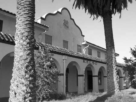
| Illustration 18 - The Spanish-Revival style Kelso Depot is an architectural landmark in the heart of Mojave National Preserve. (Photo by Eric Nystrom, 2001.) |
Beginning in 1999, interpretation began to receive more attention at Mojave National Preserve. Chief Ranger McGuinness requested funding for the development of an interpretive plan, and the Pacific West Region identified it as a major priority. Sam Vaughn, a planner from the Denver Service Center, was detailed to lead the project, in cooperation with Lynn Nakata, of the Pacific-Great Basin Support Office. Vaughn led several meetings to receive input, beginning in April 1999 and continuing through March 2001. During these meetings, Vaughn, Mojave staff, and community members worked to identify interpretive themes and recommendations of ways of putting those themes into practice. At the same time, interpretation personnel discussed plans for the Kelso Depot. Since the complex exhibits slated for the Kelso Depot were planned simultaneously with the park's Long Range Interpretive Plan (LRIP), the park's major interpretive presence will closely align with the LRIP's goals.
The Long Range Interpretive Plan, published in penultimate draft form in mid-2001, identifies six primary interpretive themes, describes prominent park resources, and lays out preferred interpretive tools. The primary interpretive themes identified by the plan are deliberately broad, and encapsulate almost everything that makes the Preserve a special place. [302] Park resources described in the interpretive plan include all of the classically awe-inspiring sites of Mojave National Preserve: specific wonders such as the Cima Dome, Kelso Dunes, and Cinder Cones areas, and vast landscapes like the Lanfair Valley and Soda Lake. The LRIP identified a "sense of discovery and exploration" as one of several goals for visitors, another pledged that one function of Mojave's interpretive program was to orient visitors to the unusual desert environment. The plan called for interpretive programs and media only in the few existing developed areas in the park, and for wayside exhibits to be kept to a minimum outside pulloffs and trailheads. [303] When plans come to fruition in 2003, the Kelso Depot will become the focal point of interpretive activities in Mojave National Preserve. The depot was still operational and open for business when the East Mojave National Scenic Area was established in 1980, and between its closing in 1985 and its eventual acquisition by BLM in 1992, one of the chief arguments for the depot's salvation was its suitability as a visitors' center. BLM never had enough funding or time to convert the building into the center that they wanted, but the bureau made stabilization of the depot a priority. In 1993, the agency repaired the roof, constructed a fence around the building, repaired damaged stucco, and installed plexiglass over the windows, which ensured the continued structural integrity of the depot. [304] The Park Service made the building's conversion into a functioning visitors' center an articulated priority in the General Management Plan. With help from Jerry Lewis, the Congressman who tried to kill the Preserve with a dollar budget in 1995 but who was also instrumental in saving the depot from the wrecking ball in 1985 and repairing the building in 1993, the park was able to secure over five million dollars in FY01 funding to restore the building. Lewis's deep concern with the history of the eastern Mojave benefited the park in the push to restore the depot. Because of extenuating circumstances, the restoration was postponed several times. On May 31, 2002, the park finalized the contract for restoration with Pacific General, Inc., a contractor experienced with NPS restoration projects, and actual work on the depot began in July 2002. [305]
One potential problem with the plan to restore the depot was the building's location in a floodplain. Executive Order 11988 directed federal agencies to avoid development in and modification of floodplains when possible. Since the General Management Plan alternative preferred by the National Park Service included restoration and stabilization of the depot, Mojave planners created a Floodplain Statement of Findings for the Kelso Depot and included it with both draft environmental impact statements issued by the planning team. Additionally, a copy was included along with the official Record of Decision for the General Management Plan, signed by NPS Pacific West Regional Director John Reynolds in late September 2001. [306]
The document noted the high risk of damage if the existing levee were to erode or vanish. Computer models showed that if flood waters broke through the levee along the Kelso-Cima Road to the east, the downhill slope and the railroad berm would serve to channel the water straight at the depot at high speed. The Park Service proposed to raise and "armor" the levee, to enable it to withstand greater floods with less likelihood of giving way. Furthermore, the plan called for regular maintenance of the levee and a reinforced drainage channel on the north side of the levee to help prevent small floods from eroding the berm. Finally, an early warning system would be created in consultation with the National Weather Service to provide park employees and visitors at the depot time to escape a threatening flood. [307]
Not all of the traditional conservation community was supportive of the plan to restore the depot as a visitors' center. During public comment on the General Management Plan, the National Parks Conservation Association and other commentors were not in favor of the plan to fully restore the building. They believed that such funds should instead be spent on resource protection, acquisition of private lands inside the park, and other more pressing issues. In their view, the many threats to the ecological integrity of the park, including grazing in desert tortoise habitat, should have been a higher priority than providing services to visitors and fully restoring one particular building. [308]
The depot visitors' center is integral to Mojave National Preserve's future interpretation plans. The depot will become a focal point for park users, providing orientation to the resources of the Preserve. Permanent exhibits for the depot were planned in conjunction with the Long Range Interpretive Plan, and explicated all of the interpretive themes for the park that the latter document identified. The plan stated the situation succinctly: "rehabilitation of the Kelso Depot is crucial to the successful functioning of this new park." [309]
In the first several years of the park's existence, the interpretive staff concentrated much of its efforts on distributing information about the Preserve and on community outreach. Developing a map for park visitors was a major priority, especially because of the swirl of misinformation about the closure of roads due to wilderness designation. Alan Bowser, Public Affirs director for the Auto Club of Southern California, contacted the Preserve and volunteered his organization to pay for creation and printing of a map. On December 8, 1995, just before Marv Jensen's departure, Bowser met with park staff, including Jensen, Martin, Buono, Dennis Schramm, Talken, Moore and Reetz to make plans for the map content. Schramm and Talken worked with the Auto Club over the following months to ensure that reads depicted on the map were not in wilderness areas. The map, printed on a single 11x17 sheet, carried travel information on the reverse side. The Auto Club agreement filled a crucial gap in interpretive materials at no cost to the financially-strapped Preserve. [310]
Mojave's information centers served to distribute park information and increase positive interactions with the public and desert residents. By the end of 1995, Mojave's information center at the base of the World's Largest Thermometer in Baker housed a successful operation, fueled by the hordes of passers-by on the interstate. A 1995 agreement with the Death Valley Natural History Association kept shelves stocked with books and other materials for visitors. The visitor center was well located to draw traffic from I-15, but some believed that the building, with the World's Largest Thermometer dominating an oversize frying pan complete with plastic eggs owned by local restaurateur Willis Herron, was perhaps less than ideal aesthetically. Tacky surroundings aside, the information center in Baker effectively introduced the park to a tremendous number of people.
|
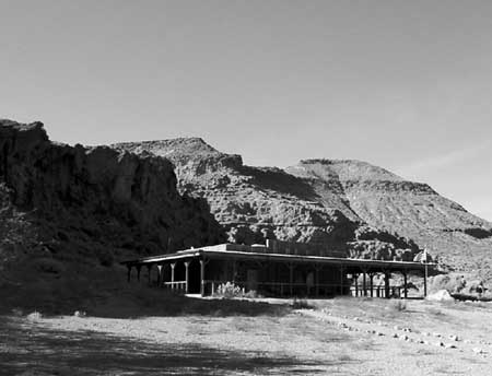
| Illustration 19 - The NPS visitors' center at Hole-in-the-Wall harmonizes with its surroundings. (Photo by Eric Nystrom, 2001.) |
Almost immediately after the Dollar Budget controversy ended, Mojave management explored the feasibility of locating a visitors' center in Needles, California. Planners anticipated that a Park Service center in Needles could draw a substantial stream of traffic from the I-40 freeway. Unfortunately, the historic downtown storefront location eventually chosen was too far from the freeway to garner even a fraction of the visitation received by the Baker center, a situation only exacerbated by inferior freeway signage. [311] However, the Needles information center served a very important community relations role. The NPS officially opened the new information center on December 13, 1997, as part of the annual Needles holiday celebration, a fact that highlighted the important outreach role. The Preserve rented its Needles office space from Bill and Nita Claypool, who had been stridently anti-park and reportedly originally suggested the Dollar Budget idea to Congressman Lewis. Years later, after extensive NPS outreach efforts, the Claypools were much more supportive of the park. James Woolsey, the interpretive ranger hired to open the Needles Information Center, can be credited with some of the change in attitude. Woolsey, a native of Twentynine Palms, California, could identify with residents of the small desert town, and they in turn could identify with him. Through newspaper articles, Woolsey made clear the potential for positive economic and social impacts that came with being a gateway community for the Preserve. The Needles information center served the community as much as the trickle of visitors who found their way from I-40. [312]
A modular building at Hole-in-the-Wall housed BLM interpretive programs and personnel prior to 1994, and after the passage of the CDPA, has been staffed by the Park Service according to seasonal demand. Most visitors to Hole-in-the-Wall were aware that they were in a park, and are often looking for more specific recommendations, unlike visitors at the Baker center. An amphitheater, constructed originally by the BLM adjacent to the Hole-in-the-Wall center, provides the only in-park facility for larger group interpretive programs. The building itself houses a small interpretive display and a selection of items for sale. Through 2002, the information center at Hole-in-the-Wall is the most traditional Park Service-like visitors' facility in Mojave National Preserve.
Wayside displays, constructed at roadside pulloffs, trailheads, and particular points of interest, are a major component of interpretation at Mojave National Preserve. Waysides require little maintenance or additional expenditures after their initial installation, a key feature in a short-staffed park like Mojave. Many wayside exhibits have been installed at key points of interest, such as the Kelso Depot, Zzyzx, and the Kelso Dunes. Preserve officials allowed some waysides installed by BLM to remain in remote areas of the park, especially if most of the information was accurate. Mojave officials typically ordered multiple copies of new interpretive displays, because of the above-average rate of replacement due to fading in the hot desert sun, as well as the occasional vandalism that seems endemic to remote locations. [313]
Portable media, such as brochures or guides, are especially suited to Mojave National Preserve interpretive activities. Many desert users are already accustomed to utilizing guides to help them find their way through a landscape without signs. One of the most successful ongoing recreation programs in the eastern Mojave utilized a portable media approach to interpretation. Dennis Casebier and the Friends of the Mojave Road developed a mileage-keyed guidebook for users of the Mojave Road recreation trail, which was first published in 1983. The group consciously rejected placing signs along the road, instead favoring rock cairns at irregular intervals. The purpose was to force travelers to utilize the guidebook to travel the trail, with the idea that visitors educated in desert etiquette by a well-written guide would be less likely to damage resources through irresponsible and reckless behavior. The experiment proved a success, and the group later developed a four-part 660 mile loop trail known as the East Mojave Heritage Trail. This second route proved to be a source of major friction between the Friends of the Mojave Road and the Park Service when CDPA-designated wilderness severed pieces of the trail and invalidated the labors and expenditures of the volunteers. The Mojave Road Guide remains one of the most popular interpretive guides to park resources. [314]
Since the creation of the park, more than thirty different brochures on a variety of topics have been created by park staff for interpretive purposes. Other interpretive brochures and trails are in the works. One proposal uses an existing network of roads and trails in the Ivanpah Mountains to link the mines of the Standard Mining District in an interpretive loop. The area's resources contain a full spectrum of mining methods and technologies, from equine-powered arrastra to cyanide heap leach open pit mining, and can explored in chronological succession with help from an interpretive brochure. Development of a unigrid map and brochure for Mojave National Preserve, a standard interpretive hand-out in national parks, began in FY 2000, and as of 2002, is in final stages of preparation. [315]
The Preserve's interpretive rangers disseminate information to the public through park publications and the park website. A park newspaper has been published annually since 1997, to deliver important information to the public that might otherwise be contained on a unigrid brochure. Maureen Lynch, a park volunteer, drafted the first issue with guidance from Sean McGuinness. The issue was later finalized and published by James Woolsey. Production and authorship duties were assumed by Woolsey for the second issue as well. After Woolsey left, Linda Slater took over its publication, and has produced two additional issues to date. Woolsey also wrote a semi-regular column for the Needles newspaper, and other interpretive staff have also contributed articles to local media. The Mojave National Preserve's park website provides supplemental information and interesting articles about specific incidents in Mojave's past, such as the experience of black homesteaders in Lanfair Valley. Woolsey constructed the first website for the park, and Slater later assumed the task of providing new content and quarterly updates. [316]
Recruitment and use of volunteers in Mojave National Preserve has also helped interpretive and other staff accomplish more without additional resources. Chris Burns, interpretive ranger at the Needles Information Center, coordinates the volunteer program for the Preserve. Volunteers act as campground hosts at both Mid Hills and Hole-in-the-Wall, and assist NPS operations at all three visitors' centers. One reason for locating the volunteer program at the Needles office is to make it easier to recruit help among the large numbers of retirees who spend winters along the Colorado River in the Laughlin / Bullhead City / Lake Havasu area. Retirees have traditionally been of tremendous support to national parks across the nation, and Mojave also benefits from the generosity of retirees and other volunteers. [317]
Mojave National Preserve interpretive rangers conduct a variety of educational outreach activities. Programs for schoolchildren were developed and met with excellent response. Schools in the area around the Preserve, including the Barstow and Apple Valley/Victorville area, have historically been underserved. "These schools haven't had a lot of attention, so any time a public speaker comes in with a little bit of enthusiasm, they love you - it's pretty easy to win them over," explained interpreter Linda Slater. [318] Typical programs are designed to help kids learn about the plants and animals of the Preserve, especially the desert tortoise, and to use that knowledge as specific examples of bigger themes in natural science. The human history of the area is also represented in Mojave's school programs, and classes frequently get to take field trips to the park itself, to see the natural and cultural resources firsthand. The Preserve's educational outreach programs have benefited tremendously from those developed by older desert parks, especially Joshua Tree NP and Lake Mead NRA. Sharing resources with neighboring parks has kept costs down and enabled the Preserve to conduct educational outreach activities which might not otherwise have been possible.
Educational outreach programs at Mojave National Preserve are not limited to K-12 classes. A large number of college students are served by the park's interpretive program. Study centers at Soda Springs/Zzyzx and to a lesser extent at Sweeney Granite Mountains Research Center concentrate collegians and researchers at the Preserve, and park interpreters are commonly called upon for informative presentations. Biology and geology courses at nearby colleges and universities make use of the Preserve as a live laboratory, one that is especially useful because of the diversity of geologic and other natural resources in close proximity to one another. Though the interpretive staff has little to do with formal research projects conducted by advanced students in the park, the results of that research are interpreted by park staff for the education of the general public.
In 2001, park managers highlighted the importance of the interpretive program for Mojave National Preserve by creating a separate administrative branch for interpretation. Mary "Jeff" Karraker, a Park Service veteran with more than two decades of service, arrived to oversee the new team. Before the split, both interpretive personnel and visitor protection forces were administered by Mojave's Chief Ranger, in an arrangement that harkened to a time in the Park Service's history when all rangers performed both interpretive and law enforcement functions. Sean McGuinness was hired as Chief Ranger in December 1996, after the Dollar Budget crisis contributed to the departure of Bill Blake, his predecessor, but like Blake, McGuinness's background was in law enforcement and visitor protection. Interpretation made large strides under McGuinness, conducting school programs, planning for the Kelso Depot, and creating the Long Range Interpretive Plan. With a myriad of responsibilities stemming from Mojave's acute law enforcement needs and a long chain of command occasionally hampering communication with the interpretive forces, it was clear that interpretation needed its own team to allow McGuinness to concentrate on the park's visitor protection services.
The history of interpretation at Mojave National Preserve has in many ways mirrored the larger history of the park itself. Budget constraints limited growth initially, though eventually new projects resulted in a growing organization and divisional independence. Early efforts concentrated on community education and outreach, while users asked for and received a promise of less development of most of the Preserve, so as to retain the "sense of exploration and discovery" that sets the park apart. Planning efforts, nearly complete, codified the future of interpretation at the park as being intimately tied to the rehabilitation of the magnificent Kelso Depot as a visitors' center, a prospect that will signal the start of the next phase of interpretive activity for Mojave National Preserve.
Together, resource and visitor protection and interpretation provide the public face of Mojave National Preserve. Both teams face challenges created by the size of the park, the diversity of Preserve resources, the park's proximity to the LA area, and tight budgets. Innovative and flexible uses of existing resources and partnerships with other agencies have proven successful strategies to increase the coverage and efficiency of interpretive services and law enforcement patrols. With recent developments such as the rehabilitation of the Kelso Depot and the use of horses for backcountry patrols, both teams are planning for larger roles in the future of Mojave National Preserve.
| <<< Previous | <<< Contents >>> | Next >>> |
moja/adhi/chap7.htm
Last Updated: 05-Apr-2004