|
Mojave
From Neglected Space To Protected Place: An Administrative History of Mojave National Preserve |

|
CHAPTER EIGHT:
RESOURCE MANAGEMENT
Resource management is an important issue in any park, as the resources, natural or cultural, are the very justification for any park's existence. At Mojave National Preserve, the unusual features of the park gave the Resource Management team several major challenges. The park addressed natural resource management issues, including wilderness, water, animals (both native and exotic), grazing, land acquisition, and soundscape threats in efforts to maintain the integrity of the natural features of the land. The Preserve also contains a wealth of cultural resources, from rock art and an old wagon road to ranching and mining remains. Legacies of former uses of the eastern Mojave created problems in the form of abandoned mine sites and hazardous materials, all of which had to be addressed by Mojave's management. The responses of the park to these situations vividly illustrate both the challenges posed by the history of human uses of the eastern Mojave and the flexibility and innovation required of park managers at Mojave National Preserve.
Natural Resources
Almost half of Mojave National Preserve's land base is designated as wilderness, a level of protection that requires the least intrusive management possible. Wilderness areas in the Preserve encompass a wide range of terrain, from dry lake playas to sand dunes to more traditional forested mountains. Wilderness inside the park is unusual for the number of former roads and routes it contains. San Bernardino County has attempted to claim some of these routes as traditional roads under RS-2477, which would turn their management over to the county. The park is resisting the county's claims. RS-2477 was a law passed in 1866 that granted rights-of-way across unreserved public lands for construction of highways; it was repealed in 1976. In 1988, Secretary of the Interior Donald Hodel opined that RS-2477 gave states jurisdiction over even the faintest trails, as long as the trails in question existed before the act's 1976 repeal. Anti-wilderness activists inspired by the Wise Use movement have attempted to use RS-2477 as a means of disqualifying lands from wilderness status. In 1996, three Utah counties bulldozed roads into BLM and NPS wilderness areas, asserting that RS-2477 gave them the right to do so, but a federal judge ruled that they were in violation of the law. The federal judiciary's ruling is a preliminary sign that RS-2477 claims will not stand up in court, but the status of Mojave National Preserve's wilderness routes has not been formally determined. [319]
Management of wilderness by the park has been guided by the document "Principles for Wilderness Management in the California Desert," which was developed by Interior agencies to articulate a directive of the 1994 Transition Action Plan. The September 1995 report, along with subsequent additions, articulated basic tenets of wilderness management, including the "minimum tool" standard. The managers of federal land in the desert recognized key differences between BLM-managed wilderness and NPS-managed wilderness created by the CDPA, but pledged that they would work together to create consistent management practices. [320]
One of the most important tasks of the park's wilderness management program was determining final wilderness boundaries and posting signs to let users know of the boundaries' existence. The maps of wilderness included with the CDPA had wilderness boundaries drawn with heavy marker on copies of fifteen minute topographic maps. This caused some confusion (as well as flexibility) in determining the exact placement of wilderness boundaries. However, thin signs identifying areas as wilderness were posted along road corridors were placed by park rangers very early to provide users with necessary guidance. Patrolling the vast wilderness areas was no easy task. In 2002, the Preserve received a temporary detachment of horses from Sequoia/Kings Canyon National Park for use in the park. The horses were kept at Kessler Springs Ranch after its acquisition by the Park Service. With proper training, rangers and other park employees could use park horses to access and patrol wilderness. This represented a tremendous improvement over the former system, which required rangers to patrol park wilderness on foot, a task complicated by the large number of wilderness areas in the Preserve and the highly arid environment.
Lack of water is the defining characteristic of deserts, including the Mojave, and concomitantly, it is one of the Preserve's most precious resources. For a desert, the eastern Mojave has a large number of water sources, which support a large variety of wildlife. During the ongoing operations of cattle ranching in the Mojave, grazers "improved" natural springs and drilled many wells, all with the goal of increasing the amount of water available for cattle. Wildlife utilized these water sources as well, and it might be surmised that populations of some species increased due to the larger amount of available water. As the Park Service received ownership of ranching lands and range improvements, control of these water sources became a park issue. Many have since been turned off or removed, with the goal of returning water levels (and dependent wildlife populations) to a "natural" level, but with nonnative species such as burros, deer, and chukar, as well as native species utilizing the scarce water, a return to pre-grazing conditions with fewer water sources may be impossible to attain. Nonetheless, ongoing removal of burros and range improvements certainly do increase riparian flora and fauna, as some early successes on former grazing lands near the Kelso Dunes can attest. [321]
Water is also at the core of one of the largest threats to the integrity of the park. Outside the southern boundary of the Preserve, Cadiz Inc. owns land under which sits an aquifer estimated to hold more than 600 billion gallons of water. The company proposes to sell the water to the Metropolitan Water District, the agency that slakes the thirst of greater Los Angeles. The district would also pump water from the Colorado River into the aquifer at Cadiz for later use, turning the ground into an enormous subterranean storage reservoir. Little is known about the aquifer or its connections to water sources inside the Preserve, but scientists fear a lowering of the water table would dry up springs and seeps throughout the desert. In 1999, Cadiz Inc. prepared an environmental assessment that was roundly criticized by the park and other agencies. The U.S. Geological Survey (USGS) noted that Cadiz Inc. overestimated the aquifer's recharge rate by "five to twenty five times." The Park Service and USGS agreed the following year to a revised report that included a system of monitoring devices to make sure the pumping did no damage to park resources. An additional delay was introduced to the project when hexavalent chromium, also known as chromium 6, was discovered in the aquifer's water. Hexavalent chromium is linked to cancer risk, but there is little agreement on standards for permissible levels of the element in drinking water. It is also hugely expensive to remove from drinking water, which put a major dent in the economics of the project. On August 29, 2002, the Department of the Interior approved Cadiz Inc.'s environmental review. Opponents of the project, including Dianne Feinstein, focused their attention on the board of the Metropolitan Water District, the last agency whose approval was necessary for the project to go forward. On October 8, 2002, the water district voted, by the narrowist of margins, to halt the project. For all its problems, the project was a tremendous threat to the integrity of the park. If the Cadiz project dried up Mojave springs, all manner of plants and animals in the Preserve would have suffered the consequences. [322]
Mojave National Preserve harbors a tremendous array of native and exotic fauna, small and large, common and rare. In sheer numbers, the tiniest park residents, including microbes and fungi that help make up cryptogramic desert soils, are extensive but poorly understood. The same could be said for most of the park's smallest fauna, including common insects like the black widow spider and insects found nowhere else, such as a small cricket that lives only on the Kelso Dunes. The Preserve was named one of America's top Globally Important Bird Areas by the American Bird Conservancy in 2001, in recognition of the important habitat it provides. [323]
Of the diverse fauna found in Mojave National Preserve, no creature receives as much attention as Gopherus agassizii, the desert tortoise. In the late 1980s, scientists witnessed an alarming drop in desert tortoise populations throughout the Mojave, including in the East Mojave National Scenic Area, and obtained listing of the tortoise as a threatened species. The tortoise is extremely sensitive to changes in habitat, a fact noted in the 1994 Desert Tortoise Recovery Plan, and bioregional planning and early Mojave National Preserve planning efforts were tied in part to the need to manage the desert tortoise's habitat as a functioning ecosystem. Since the creation of Mojave National Preserve, nearly all decisions relating to the land have taken the desert tortoise into account to some extent. Superintendent Martin noted that it was not park policy to manage resources for the benefit of a single species, but the vast array of management decisions called for by the Desert Tortoise Recovery Plan create a de facto situation where the needs of the tortoise seem to dominate management decisions. [324]
Even unconventional projects required park staff time for desert tortoise monitoring and compliance. For example, when Jonathan Mostow, director of the movie "Breakdown," wanted to film portions of his suspense movie in the park, Doug Scovill was detailed to ensure that the movie cast did not harm a single desert tortoise. "They were very cooperative, but any time they went off the road I would go and inspect the area," remembered Scovill. The crew spent three twelve-hour days filming in the Preserve, and Scovill was with them the entire time to protect the endangered tortoise. [325]
While the desert tortoise received complete management attention to attempt to save the species, the history of another native park species, the bighorn sheep, was more complex. Bighorn population levels were historically very low, and in the late 1800s the state of California made it illegal to hunt them. Enhanced water supplies in the desert, probably including water intended for cattle grazing but also specially-designed guzzlers intended for bighorn sheep, allowed the population to grow, especially in the area near the Old Dad Mountains. By the mid-1980s, there were enough bighorn in that area that BLM captured some of them and introduced them to other parts of the Mojave where bighorn had vanished. In 1987, California Department of Fish & Game went one step further and began to issue a very limited number of hunting permits every year for bighorn sheep. In a break with tradition, all of the bighorn tags save one are awarded by computer-generated random lottery, the reserved tag is auctioned off to the highest bidder, often for more than $100,000. [326]
Bighorn embody the kind of awkward management dilemmas found in the Mojave National Preserve: removing guzzlers would create more natural conditions in the park but would probably lead to the decline of the bighorn population, which the park is obliged to protect at natural and healthy levels. However, the loss of the surplus bighorn would likely emphasize hunting impacts on those left and might create a situation where the sheep need to be protected from hunting again. This analysis seems ironic in light of the fact that in the opinion of some CDPA activists, bighorn hunting, rather than deer or game bird hunting, was the real reason behind Mojave's "preserve" designation. [327]
Bighorn have been at the center of several management complications for Mojave staff. The most serious incident took place in 1995, when thirty eight bighorn drowned in a freak accident at a guzzler. [328] Jerry Lewis and anti-park forces called the tragedy a result of Park Service mismanagement, and used the incident as justification for the Dollar Budget. Lambing protections for bighorn in the Clark Mountain area may put the park at odds with a vocal group of rock climbers, who consider Clark Mountain extremely good climbing terrain. "Discovered" in 1992 by rock climber Randy Leavitt, who later published a guidebook to climbing the area, Clark Mountain was described by a national rock climbing magazine as "one of the most awe-inspiring and intimidating sport cliffs in America." Prior to the CDPA's designation of the area as wilderness, some climbing bolts were installed in the rock, but no new installations have been allowed since then. [329]
Most of Mojave National Preserve faces a four-hoofed problem that has its roots in the human history of the area and will remain a headache for the park because of legislated sentiment for the Old West. Burros, a descendant of the Sumerian ass, are hearty, easy to train creatures, features which made them attractive to desert prospectors. Modern wild burros are the descendants of animals who broke free or were turned loose in the desert by miners unable to pay for feed. Burros pose a considerable challenge to other desert dwellers: they will take control of water sources and prevent other animals, such as cattle and bighorn sheep, from using them, and consume a tremendous amount of forage that other animals, including the desert tortoise, depend upon. As recently as the late 1960s, ranchers kept the burro population under control by shooting animals that threatened their cattle's water or forage supply. [330]
Animal humane societies, worried about a decline of sightings of wild horses, pushed for Congress to protect the invasive animals on public lands as a reminder of the Old Western past. In 1971, Congress passed the Wild and Free-Roaming Horse and Burro Act, which formally mandated the continuing existence of such animals on BLM land where they already were present. BLM took over management of the issue from ranchers, but was reluctant to kill the burros because of pressure from animal rights groups. Burros are as concupiscent as rabbits - herd growth rates approach 20% annually - and the population exploded under BLM management.
The Park Service was under no obligation to allow burros to remain in the park, as the agency is exempt from the Wild Horse and Burro Act. NPS regulations require the park to act as a functioning ecosystem, and the impacts of burros were both negative and substantial. Accordingly, the Preserve made the burro control program one of its top priorities. One statistic illustrates the size of the burro problem: BLM estimated that 130 burros constituted the maximum-sized herd that could exist in the eastern Mojave without ecosystem damage, but a NPS burro census conducted in October 1996 found over 1,500 animals in the park. Managers were so alarmed by the burro problem that the park used $100,000 of base budget money in 1997 and again in 1998 to initiate the burro removal program. Doug Scovill, promoted to chief of resources after the Dollar Budget crisis had passed, hired Chris Stubbs to tackle the burro problem. The park applied for Natural Resources Preservation Program money, and received $900,000 over three years to continue the program through FY01. Beginning in 1997, the Preserve utilized a combination of water trapping and helicopter roundups to capture burros, snaring 3,000 animals over five years. BLM budgets $1,000 per burro to remove the animals from lands it controls, but Mojave National Preserve accomplished the task for about $300 per burro, largely because of the success of relatively inexpensive water trapping facilitated by Mojave's extensive ranching infrastructure. Wholesale slaughter of the animals was not a politically feasible option. BLM agreed to take a limited number into its adoption program, and the park was able to place 1998's group of captured burros with a private agency which agreed to sell them to the public. Beginning in 1998, Mojave National Preserve entered into an agreement with the Fund for Animals, which operated the Black Beauty Ranch, a haven for unwanted animals. Cleveland Amory, president and founder of the Fund, agreed that the ranch would take up to 300 burros per year from the Preserve at no charge - the Park Service was only obligated to pay for transportation to Texas and a one-time veterinary check. The agreement to adopt Mojave burros was remarkable, as Amory generally took an adversarial stance toward the National Park Service. [331]
Despite extensive Park Service efforts, the burro problem has not been entirely eliminated. In the Clark Mountain area, burros from a BLM-managed herd stray into park lands. After grazing in the area is retired, the Park Service will likely fence the boundary to prevent burros from entering. Such a fence would be constructed with special gates that would permit jumping animals, such as deer and bighorn sheep, to pass through, but prevent non-jumping animals like burros from gaining access. Other parts of the Preserve, including the "keyholes" in the Mescal Range and near Castle Mountain Mine as well as the southwest part of the park near the Bristol Mountains, are adjacent to BLM lands that support burro populations not considered part of a managed herd. The boundary in these areas will likely have to be fenced to allow total removal of burros from the Preserve. [332]
|
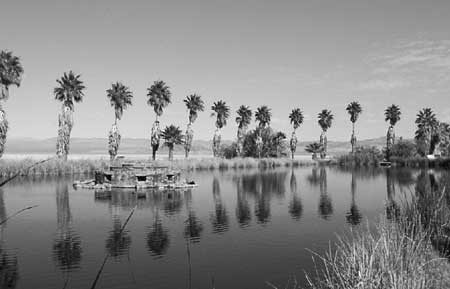
| Illustration 20 - Lake Tuendae at Zzyzx is an artificially-supported habitat that harbors the only population of endangered Mojave tui chub. (Photo by Eric Nystrom, 2001.) |
While most attention has focused on removal of non-native ungulates such as burros and cattle to promote the health of the desert, the park also began investigating the possible return of a once-native species to the area. Anecdotal evidence strongly suggests that pronghorn antelope once lived in the Preserve. More research would be necessary to determine if a reintroduction program can be justified, but park managers are cautiously supportive of the idea. At least one wolf has been found in the eastern Mojave in the twentieth century, but more research would be necessary to determine if the creatures were ever present in the area in numbers that would justify reintroduction. [333]
In most of the park, managers are making efforts to move ecosystems to a more sustainable state, with less human intervention necessary in the survival of any and all park flora and fauna. This is not the case at Zzyzx, where a population of endangered Mojave tui chub are maintained in the artificial ponds at the site. The Mojave tui chub is the only fish native to the Mojave River. Sometime before the 1930s, a population of the fish came to live in holes at Soda Springs, likely during one of the Mojave River's periodic inundations of Soda Lake. In the 1930s, a related non-native chub was introduced to the Mojave River, and over time, hybridized with the native fish, merging so completely that by 1970 no genetically original tui chub were thought to exist. In 1970, the U.S. Fish & Wildlife Service listed the tui chub as an endangered species, when the fish in ponds at Zzyzx were discovered to be genetically distinct, native Mojave tui chub. Since that time, the fish population has been maintained by BLM and the Park Service. To provide appropriate habitat, the ponds they inhabit must be cleaned of cattails and dredged once a decade. In 2001, the Park Service issued a finding of no significant impact on an environmental assessment that described the dredging process. A cofferdam would be constructed to divide Lake Tuendae, then all of the fish in the western half would be captured and moved to the other side before most of the cattails were cut away and the pond dredged to a depth of six feet, a significant improvement of habitat for the tui chub population. [334]
The long-term benefits of ecosystem restoration motivated NPS participation in the AT&T's removal of an underground telecommunications cable from park lands. The cable, known as the "P140 system," was constructed in the mid-1960s to be impervious to nuclear assault. The system consisted of the cable itself as well as repeater huts, manholes, and an access road with signage. By 1996, AT&T decided that the burdens of maintenance on the outdated equipment and patrols to prevent vandalism were not justified by the obsolete system. The NPS welcomed the opportunity to remove the manmade structures and receive the right-of-way back from AT&T, and agreed to lead the federal side of the development of an EIS for the project. Public scoping meetings were held in June 1997, and the Draft EIS was available for public comment from late December 1997 until March 1998. A final EIS was issued in May 1998, and the Record of Decision, confirming the preferred alternative of the EIS, was issued August 17, 1998. After some delays related to the Special Use Permit process, AT&T removed the cable then restored the right-of-way, and finished by mid-November 1999. [335] The land associated with the right-of-way occupied by the AT&T cable was valuable, but the removal of structures and restoration of the right-of-way was of greatest importance for the future of park resources.
For Mojave National Preserve, grazing is a controversial and important issue that cannot be ignored. Widespread political and cultural overtones help make grazing a sensitive issue for everyone involved. As such, park management tread carefully but deliberately in the arena of grazing management. The Park Service has long viewed grazing as antithetical to its mission, permitting the activity in certain parks only when political circumstances absolutely required it. Park Service culture and policy have historically limited grazing in national parks, initially to differentiate itself from the Forest Service, and in later years to help maintain ecosystems. The long history of grazing in Mojave National Preserve and permission for its continuation in perpetuity by legislative action complicates natural resource decisions, making the goal of a functioning pre-grazing ecosystem frustratingly difficult to achieve.
At the time Mojave National Preserve was established, all or part of eleven BLM grazing allotments, established under the 1934 Taylor Grazing Act, were included within the park. Superintendent Marvin Jensen brought a background in range conservation with him and established a friendly management tone toward grazers. All existing operations were issued NPS permits to continue with their ranching activity, and management of the range did not differ substantially from BLM activity.
|
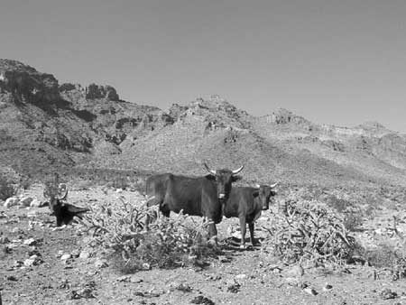
| Illustration 21 - Desert cattle, such as these belonging to the 7IL herd, graze portions of Mojave National Preserve's landscape. (Photo by Eric Nystrom, 2001.) |
The Park Service also took concrete steps toward limiting grazing when possible, providing that the situation was politically feasible. The portion of the Piute allotment within the park was for ephemeral forage only and was in desert tortoise habitat. Management decided that any ephemeral forage must, at behest of the Desert Tortoise Recovery Plan, be used by the desert tortoise, so a permit to graze ephemeral forage would never be issued. A second allotment, Crescent Peak, was owned by a conservation group, who had purchased it as part of a move to eliminate grazing in southern Nevada. Since no active grazing was taking place, the permit was retired. Not long after the creation of the Preserve, the rancher who held the Clark Mountain grazing allotment passed away, and Park Service regulations forbid the issue of a permit for renewed operations there. Irene Ausmus held the Round Valley allotment, just large enough for her to keep her two pet cows in feed, but not so big as to cause significant resource issues for the park.
Major cattle operations in Mojave National Preserve were essentially controlled by three groups. The Overson family was responsible for the largest share of the acreage, with the OX and Kessler Springs ranches owned by Gary and Linda Overson, and the Granite Mountains ranch owned by their son, Clay Overson. Next in size were the Valley View and Valley Wells allotments, both owned by Richard Blincoe, an Idaho agriculturalist, and managed by Tim Overson. The Blair family operated the 7IL Ranch on the Colton Hills and Gold Valley allotments. During the CDPA debate, the Blairs worked to preserve their ranching way of life, and an original clause that specified a twenty five year sunset on Mojave ranching was removed from the bill largely as a result of their efforts. In 2001, the park concluded an arrangement begun in 1998 where the 40 acres of park land that included the 7IL Ranch headquarters were swapped to the Blairs for 40 acres of undisturbed land in critical desert tortoise habitat owned by the ranching family. Touted as a "win-win" situation for the Blairs and the Park Service, the deal also showed locals that the government was not out to destroy family ranchers in the Preserve. [336]
Ranch lands are identified in the California Desert Protection Act as top priorities for acquisitions. In contrast to the Blairs' opposition to the CDPA, Gary Overson specifically requested that his ranchlands be included in the park, to guarantee an acceptable purchase price should he decide to sell his property. Beginning in 1995, Deputy Superintendent Mary Martin worked to coordinate the sale of Overson's ranch to the National Parks Conservation Fund, but after years of contract negotiations, the deal fell through at least in part as a result of strict timelines and reluctance on the part of BLM. Undaunted, Martin sought another donor, but Overson doubted the ability of the Park Service to complete a buyout, as a result of the earlier failed experiment. Overson looked for another private buyer for his ranch, but the park made it clear to the buyer that issuance of a new grazing permit "is not certain" and that "the application process ... is subject to lengthy and potentially costly delays and complex administrative and legal procedures and challenges." [337] As a trial run, Mojave National Preserve and the National Park Foundation worked to move the Granite Mountains Ranch, owned by Overson's son, to NPS control. The deal was completed in April 2000, and set the stage for the park's successful acquisition of Gary Overson's holdings in January 2001. In 2002, Blincoe also agreed to sell his ranches to the park. [338]
The effect of the Overson and Blincoe allotment acquisitions cannot be overstated. Total grazing in the Mojave National Preserve was reduced from some 37,000 Animal Unit Months (AUMs) to approximately 4,000 AUMs, leaving the 7IL as the only major cattle ranch in the Preserve. [339] The elimination of grazing will move the formerly grazed lands closer toward a goal of a more naturally functioning ecosystem. The Park Service also gained control of a tremendous number and variety of structures associated with cattle ranching in the eastern Mojave desert. In 2002, a consultant produced a National Register district nomination for the Overson properties, signifying their historic importance to the east Mojave; future plans may include interpretive programs and utilizing some structures for NPS employee housing. The ranches acquired by Mojave National Preserve included some private lands among the holdings, but the most valuable assets to the park were the grazing permits and the ranchers' water rights. [340]
Other parties owned most of the private land in the Preserve. About half of that land was owned by individuals, a legacy of homesteading days, but the other half - some 87,000 acres — was under control of the Catellus Corporation. The Catellus holdings, made up of checkerboard sections across much of the park, were originally granted to the Southern Pacific Railroad in 1864 by the federal government, as incentive to build the line that is today's Burlington Northern Santa Fe. Catellus wanted to gain maximum value for stockholders, and was interested in disposing of its desert lands if possible. In 1996, a $36 million deal partially fell through, because the federal government's decision to spend $380 million on 7,000 acres of old-growth forest in northern California left the Catellus deal short of funds. The company put pressure on the government by sending teams to survey their desert lands for mineral and development opportunities, and put up large "For Sale" signs along roads near the Preserve. The Wildlands Conservancy, a non-profit group, stepped in to help negotiate a deal. In 1998 and 1999, the non-profit group and Catellus came to an agreement that would transfer 487,000 acres of land to the federal government for $54.6 million, of which $18.6 million would come from the private group and the rest from the federal government. Rep. Jerry Lewis and other Republicans blocked part of the money - that which would purchase Catellus lands inside the Preserve - until a deal to allow expansion of Ft. Irwin was consummated. On July 27, 2000, the government took control of Catellus lands within Mojave National Preserve. Of the $20 million received by Catellus for the 184,000 acres of lands in and near the park, $15 million was raised by the Wildlands Conservancy, and the federal government paid the rest. [341]
Development, land use, and urban sprawl are some of the biggest threats to the Mojave National Preserve. Citing statistics that indicate that McCarran Airport will reach capacity by 2014, airport planners have long cast their eye on the northern part of the Ivanpah Valley, between Jean and Primm, as ideal for an additional airport to serve the Las Vegas area. The valley already had easy transportation access to the metropolis because both the Union Pacific Railroad and a recently-widened Interstate 15 run through it. In 1998, Nevada representatives introduced legislation in Congress to allow Clark County to purchase more than 6,000 acres from BLM to build the airport. Opposition focused largely on impacts that the airport would have on the Preserve, the boundary of which is less than 15 miles from the proposed site. The airport would destroy the park's sense of natural quiet, adversely impact air quality and nighttime darkness, and bring urban sprawl to the Mojave's doorstep. In the House, the measure was defeated along with a large number of other measures in an omnibus anti-environment bill; the Senate version languished in committee. In April 1999, the National Parks Conservation Association listed Mojave as one of the ten most endangered parks because of the airport threat. In May, Nevada's Congressional delegates again introduced legislation to transfer land for the airport, but added some weak protections against environmental damage as well. Again, the legislation was delayed in committee in the Senate, where Dianne Feinstein and others expressed their concerns over the impacts to Mojave National Preserve. After consultation with environmental groups added language stipulating that a full EIS would be completed prior to construction and that the land would revert back to BLM if the airport was not built in 20 years, the House overwhelmingly passed the airport legislation in early March 2000. In July, Senator Harry Reid added several amendments in order to get the stalled bill out of committee. Most crucially, one amendment required that "any actions ... shall specifically address any impacts on the purposes for which the Mojave National Preserve was created." The full Senate approved Reid's bill in early October, and President Clinton inked his approval on October 28, 2000. [342]
After passage of the airport land legislation, Mojave National Preserve instituted a program to document the natural soundscape to better demonstrate that the airport would harm park resources. In a series of remote locations throughout the Preserve, park staff have set up monitoring stations with sensitive microphones that constantly record the decibel level of ambient sound to a computer log file. If a noise above a certain threshold is experienced for more than a certain length of time, the computer saves the sound itself as an electronic file. The park is also encouraging research on the effect airplane sounds would have on bighorn sheep lambing and on the desert tortoise. Dennis Schramm summarized the park's airport strategy:
"We just want a realistic evaluation of alternative sites, and that's what we're going to try to get. We also want a realistic evaluation of the noise impacts over Mojave. And whether or not that piece of legislation is able to stand up and they will actually turn the airport down - only time will tell." [343]
Cultural Resources
Mojave National Preserve's cultural resources are extensive and multifaceted. Prehistoric habitation, ranching, homesteading, mining, railroading, and military operations have scattered cultural resources throughout the park, and the dry climate and remoteness of some of the sites have helped to preserve them. Most of the park's cultural resources are managed under a philosophy of benign neglect, a consequence of limited resources and personnel. The same "sense of discovery" that limits widespread interpretation of park resources also makes them more difficult to find, which aids in their preservation.
|
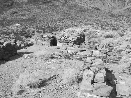
| Illustration 22 - The rock walls of the military outpost at Piute Creek were constructed in 1867-1868. (Photo by Eric Nystrom, 2001.) |
Extensive rock art exists throughout the Preserve; so much so that archaeologist Robert Bryson, cultural resources chief at Mojave, considered the area to be one of the biggest collections of rock art in the world. Much of it has been vandalized, but some rock art is entirely intact. Even at vandalized sites, important resources may still remain, especially under the soil. All known archaeological sites in the Preserve were entered into an NPS database called ASMIS, set up by Doug Scovill in the early days of the park. More recently, the data have been updated and refined by Bryson in a new effort to fully document the resources of the park. [344]
Only low rock walls remain of the military outpost at Piute Creek, known colloquially as "Fort Piute." This area was declared an Area of Critical Environmental Concern by the BLM, in recognition of both the cultural values of the fort and the Mojave Road, as well as the extensive flora and fauna supported by Piute Creek, the Preserve's only perennial stream. In 2002, Park Service experts assisted the Preserve in stabilizing the remains of the walls, which were steadily crumbling under pressure from visitors and plants. Other former military sites along the Mojave Road, including the outpost at Rock Spring and that at Marl Springs, are not as well preserved as Piute Creek. These sites receive considerable traffic for their locations, and therefore are also a focus of increased ranger patrols to ensure no degradation of the resource takes place.
The history of the nineteenth-century military in the eastern Mojave is bound up with the history of another unusual historical artifact, the Mojave Road. After a volunteer group published a four-wheel drive guide to the trail in 1983, the route became a favorite of off-road vehicle users, many of whom travel in groups. BLM did not require permission for large groups on the Mojave Road, but the NPS asks groups with more than twenty five people to obtain a free group use permit, to help the park better monitor road traffic. An informal tally of road users has been kept by the Friends of the Mojave Road since the trail's 1983 rebirth, by counting the numbers of signatures in a sign-in book kept in a mailbox on a remote part of the route. A cultural resource inventory for the Mojave Road cultural landscape was completed, and a National Register Nomination is underway. The General Management Plan's preferred alternative explicitly provides for the possibility of commercially guided tours over the Mojave Road. [345]
The Kelso Depot is one of the most significant buildings in the Mojave National Preserve, and plans to rehabilitate the structure into a visitors' center have driven management decisions about it. [346] Since the formation of the park, the depot has been heavily patrolled. Portable restrooms were placed near the depot in 1995 to meet visitor demands, and in 1998, wayside exhibits were produced and mounted near the building to tell some of its history. [347] Pacific Great Basin Support Office historian Gordon Chappell and Denver Service Center Historical Architect Robert Carper led a team that produced a Historic Structure Report of the depot, published in January 1998. The Kelso Depot Development Concept Plan, along with a Floodplain Statement of Findings, was included with the General Management Plan as the latter was developed. In essence, the Development Concept Plan calls for the depot to be returned to a condition that approximates its pre-1940 look. Modern improvements, such as additional landscaping, external restrooms, and parking would be designed in such a way that they would be partially shielded from view, and would not detract architecturally from the depot. As funding becomes available, other nearby buildings, especially the Kelso Schoolhouse and the Kelso Post Office, will be restored as well; stabilization of the schoolhouse took place in 2002. In August 2001, the depot was added to the National Register of Historic Places. [348]
The Kelso Depot is associated with the nearby Vulcan Iron Mine, part of the Kelso Historic District. In early 1998, Hugh Davenport, owner of the Vulcan Mine and surrounding patented land, donated the former iron mine to the park. Shortly before the creation of Mojave National Preserve, a company proposed filling the pit with shredded tires, but public reaction to the plan was very negative and San Bernardino County rejected the proposal. [349] The Kelso Depot and Vulcan Mine district provide a cultural link from the history of the eastern Mojave to nationally significant railroad history, industrial history, and history of the home front during World War II.
|
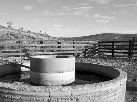
| Illustration 23 - The Rock Springs Land & Cattle Company constructed this circular water trough and lumber corral near Barnwell sometime between 1894 and 1919. (Photo by Eric Nystrom, 2001.) |
In contrast, the widespread ranching landscape in the eastern Mojave does not seem significant on the same scale at first glance, but in actuality reflects nationally important business and natural history themes. Extensive ranching structures dating from the 1800s to the modern day were inherited by the Park Service as grazing permits were acquired and retired between 1998 and 2002. Beginning in late 2001, the park contracted to have a National Register district nomination completed for the historic Rock Springs Land & Cattle Company, represented by the Kessler Springs and OX Ranches. Some of the headquarters buildings and range improvements will be retained for interpretation, some newer non-contributing features and fences will be removed, and some buildings, especially at Kessler Springs, will be adaptively reused as park employee housing and maintenance facilities. Many of the historic ranching features are in very good condition, because they were in continuous use until after the Preserve was created. [350]
|
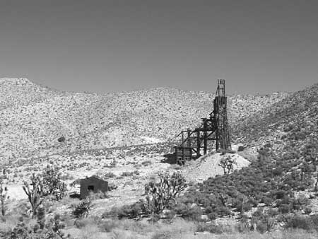
| Illustration 24 - The headframe of the Evening Star Mine, in the Ivanpah Mountains, provides a substantial reminder of Mojave National Preserve's mining heritage. (Photo by Eric Nystrom, 2002.) |
Just as ranching features have been nominated as historic districts, plans under development grant some facets of Mojave National Preserve's mining heritage similar treatment. The Standard Mining District, located in the Ivanpah Mountains, will be evaluated for historic significance in 2002, and others will be addressed in years to come. Before the interest in the Standard area, most mine sites did not receive park management attention for their value as historic artifacts, but instead for their hazards and potential for renewed mining. Since abandoned mines are located in remote areas and often have existing buildings, they have been used by clandestine drug manufacturers with alarming regularity. Regular ranger patrols have cut down on the likelihood of this kind of use. Some sites, especially those with less extant historic value, have been declared hazards and rehabilitated. Rainbow Wells was a site of mining and ranching activity from the early 20th century, but most recently harbored an illegal methamphetamine lab in 1998. After the lab was found and removed, everything at the site was sent to a landfill outside the park. All that is left of Rainbow Wells today is a few Joshua trees and some uneven ground.
Mining in the area that is now Mojave National Preserve has long been a major use, and was recognized by the California Desert Protection Act as a use that would be permitted to continue after the creation of the Preserve. In general, mining is not encouraged in national parks. For a long time, the Park Service had no means of regulating mining on park lands. After the NPS was unable to prevent a company from establishing a major mine just inside the borders of Death Valley National Monument in the late 1960s, Congress passed the Mining in the Parks Act in 1976 to give the NPS powers to regulate mining activity on its lands in such a way that is compatible with the agency's mission. The act, codified in the so-called "9A regulations," gives the Park Service broad powers to restrict potential mining operations, and establishes strict procedures for creating new mines in parks. The mining issue in Mojave National Preserve can easily be divided into two categories. One half concerns the past - former mines in the Preserve which now pose liabilities to the park; the other side concerns the future of mining in the park, evaluating claims that could become new mines. The two overlap because only claims established before 1994 could become active mines, and many claims exist at the sites of mines that were worked in the past.
Historically, exploration and extraction of minerals was long one of the top industries in the Mojave desert. The region was geologically very active, which increased the number and variety of minerals deposited in the desert rock, and lack of obscuring plant cover made mineral deposits easier for prospectors to locate. Native Americans and possibly Spaniards and Mexicans mined in the area before California became part of the United States. Beginning in the 1860s, Americans mined the eastern Mojave for a wide variety of minerals until the creation of Mojave National Preserve in 1994. Each of these sites of former activity left a legacy on the landscape, of shafts, adits, and above-ground structures. It is possible for the park to trace the owners of some of the newer mines, and demand reclamation of the site. Those mines for whom no responsible party can be found are known as abandoned mine lands (AML). Mojave National Preserve's list of AMLs includes some 419 entries as of 2002 [351]
In 1998, the park hired Andrew Lesczykowski as a restoration geologist to deal with AML issues. Lesczykowski, a U.S. Bureau of Mines veteran, was part of a team in the early 1990s that produced a report that evaluated the mineral resources of the area that is now the Preserve. That Bureau of Mines report, which listed all known historic mines in the eastern Mojave, has been used by Preserve staff as a preliminary list for evaluating the status of abandoned mines in the area. The park has created a database listing all known AMLs, and is systematically evaluating them to determine the extent of the workings, the safety hazards involved, the historic period of the remaining features, and any chemical or hazardous materials concerns that may be present at the site. Armed with this data and with the concurrence of experts in relevant fields, mines can be reclaimed in a variety of ways. In some situations, such as the Rainbow Wells site, the existing features were not historic and the place was simply a hazard. The site was cleaned up, trash and debris hauled away, and the ground recontoured and ripped up to promote plant growth. At other sites, shafts may be filled with dirt originally taken from them, if it is piled nearby. Other shafts and tunnels might be filled with a polyurethane foam plug, several feet long, that expands to fill the opening, then backfilled with earth. Others may simply be left alone, if they are remote enough to pose no visible threat or if they harbor bat habitat, as many mine tunnels in the Preserve do. [352]
All total, some 15,000 claims have been staked in the area that is now Mojave National Preserve. The number of "active" claims, meaning those whose paperwork and filing fee was up to date, exceeded 3,000 when the park was established in 1994. The CDPA placed special restrictions on mining claims in the Preserve. All claims, like those in other parks, are subject to the Mining in the Parks Act, or "9A" regulations. In an unusual twist, the CDPA required that the Preserve conduct validity exams on all active claims in the park, rather than only those claims that propose new operations. This requirement means that all of the claims in the park will eventually be rendered either valid or invalid, permanently eliminating the threat of mining on those found invalid and identifying any valid claims for purchase by conservation forces and "solving" the future of mining in Mojave National Preserve. The requirement also means that considerable money and effort must be put into the validity examination program before the process is complete. [353]
The Park Service took steps to reduce the list of active claims in August 1998, when Ted Weasma and Gordon Pine, both certified mineral examiners, were hired to work in the Geological Resources Division in the Denver Service Center. The two were assigned to Mojave, with the understanding that they would work on validity exams in Joshua Tree and Death Valley as well. After one year, Weasma and Pine were administratively transferred to the Preserve, though the duo continued to periodically assist other parks. They have reduced the list of active claims from over 3,000 to 486 by mid-2002, almost exclusively through monitoring active claim administrative procedures.
To have a valid claim under 9A regulations, a series of standards must be met. There must be a mineral present in a quantity and of a quality that a "reasonable person" would expend time and money extracting it. Importantly, the mineral must be marketable as well. Many claims fall on the question of marketability. A hypothetical claimed gold deposit that is big enough, if mined, to make a profit at 1994 prices, is valid. If the market dips the following year, making the mine break even at best, then the claim is permanently invalid, even if the market rebounds. For a claim to be valid, it had to have been valid at the time the claim was staked, valid at the time of the passage of the CDPA, valid at the time of examination, valid at the time of an administrative hearing, and valid all of the times in between. Given the variations inherent in mineral commodity markets, the marketability standard sets a very high hurdle for claims to be found valid. In addition, fees must be filed promptly. If the owner of a claim fails to file paperwork or an annual fee on time, the claim is rendered permanently invalid. The end result is a process that, in Weasma's words, makes it "very, very difficult" for a miner to prove his claim valid. These difficulties are posed by mining law, not by Mojave National Preserve or the Park Service. Weasma and Pine both emphasized that their professional reputations rest on the impartiality of their work, and Pine added that, "the Park Service has never told us to find a claim invalid." [354]
As funding permitted, Weasma and Pine guided validity examinations for active claims. No validity work could be done in the field until the process stipulated by the National Environmental Policy Act was completed, a procedure which took two years. Some exams are contracted to outside vendors and supervised by the park; six contracts have been awarded as of mid-2002. Pine and Weasma worked on exams themselves as well, but because of the length of the exams and the limited funding available to them, only a handful have been initiated.
If a claim were ever found valid, the owner would need to submit a Plan of Operations for the park's approval before mining or other activity could begin. Park regulations would require a reclamation bond sufficient to return the property to a pristine state after the mine exhausted its working life, and any wilderness or access issues would have to be addressed as well. As of mid-2002, four mines have activity pending park approval. The Morning Star Mine has proposed a reclamation operation, the Golden Quail Mine has a potential cleanup in the works, and the Cima Cinder Mine and the Telegraph Mine have Plans of Operation submitted to the park. [355]
The Cima Cinder Mine was the only mine in Mojave National Preserve that was in operation when the area became part of the National Park System. Its cinders were used mostly in the production of cinder blocks that were used in the southwest. After the death of the original owner of the mine, Emerson Ray, the mine was operated for the family trust by Lorene Caffee, his daughter, and her husband Terence Caffee. In the early 1990s, a BLM validity examiner determined that the Caffees could patent their claim, and the application to turn their mine into private land advanced to Washington DC, where it remained unsigned, victim of a national political decision not to grant any more mineral patents on federal lands. [356]
After passage of the CDPA, Superintendent Marvin Jensen issued temporary permits to Cima Cinder and several other small operations to continue mining until they prepared a Plan of Operations that met Park Service standards. Cima Cinder continued to operate without a permanent Plan of Operations under several extensions of the temporary permission, with support of Rep. Jerry Lewis and Sen. Dianne Feinstein, because of the financial hardship that would have resulted from a shutdown. [357] In August 1999, the Western Mining Action Project, headed by the Southwest Center for Biological Diversity, filed notice of a lawsuit against the NPS for allowing the mine to continue to operate without a valid Plan of Operations. The day before the lawsuit was to be filed, Superintendent Martin decided to shut down the mine. She and Chief Ranger Sean McGuinness served notice on the Caffees on August 10, 1999 in an atmosphere fraught with anxious undertones. [358] NPS Regional Director John Reynolds eventually persuaded the superintendent to take McGuinness, but Martin initially wanted to go by herself:
"I was nervous about taking anyone else out there with me. These guys had threatened to kill anyone that shut them down, so I decided I don't want to put anyone else in danger. ... I didn't think he'd shoot me but I did think he'd shoot someone else. I figured he knew me, and sometimes these guys are kinda macho and they can't, you know, be rude to a female, but they could to a male. So I was afraid to have somebody else go out there in case he decided to do something weird - you can never tell." [359]
Since the mine has been shut down, the market that the Caffees once served has found other sources of cinders, which makes it unlikely that the mine will ever again meet the marketability standard to be declared a valid claim. The Caffee family places the blame on the Park Service, charging that Lorene and Terry Caffee submitted a revised Plan of Operations that was never acted upon by Preserve staff. The park prepared an environmental assessment, which has not gone out for public review because the Caffees requested the opportunity to comment first and have not done so. [360] Ultimately, the case of the Cima Cinder Mine is a testament to the byzantine nature of mining regulations and the unusual character of resource management work in Mojave National Preserve.
Just as extensive mining in what is now Mojave National Preserve causes the park to stand apart as an unusual case, the Preserve's management faced an unusually large number of hazardous materials problems as a result of historic activities on what are now park lands. All national parks have to concern themselves with hazardous materials to a certain extent, because so many things in modern use are hazardous when disposed of improperly. Mojave National Preserve avoided some of the most common park-based hazardous materials scenarios because the Preserve joined the national park system after in-park development, with their associated trash dumps and motor maintenance shops, fell out of favor. Nonetheless, because of its neighbors, its mining past, and the history of use of the desert as a dumping ground, Mojave National Preserve has faced an extensive set of non-emergency hazardous materials problems.
The most complex hazardous materials threat that the park has faced originated just outside park boundaries. The Molycorp Inc. Mountain Pass Mine and Chemical Processing Facility consists of an open pit rare earth metals mine and milling facilities nestled in the hills between I-15 and Clark Mountain. The host rock, estimated to be 2.5 billion years old, was originally claimed as a gold deposit, the Sulphide Queen, in 1936. Its history as a rare earth or lanthanides mine began when Herbert Woodward and Clarence Watkins, prospectors searching for uranium in the post- World War II atomic boom, discovered that the area possessed a radioactive profile. The uranium sought by prospectors was present only in small quantities, but the presence of bastnasite, ore that harbors extremely rare elements collectively known as lanthanides, ensured the profitability of the operation. Molycorp bought the claims in 1950 and began mining in 1951, although the production of lanthanides was not the main focus of the operation until its purchase by UNOCAL in 1977. [361]
In 1980, Molycorp constructed a 14-mile underground wastewater pipeline between its Mountain Pass facilities and evaporation ponds on Ivanpah Dry Lake. Approximately five miles of this pipeline was inside the boundaries of Mojave National Preserve when it was created in 1994. Molycorp told regulators that the pipeline would be carrying nothing more than highly salty water, a byproduct of the milling process, so regulators allowed the company to drain its wastewater into open evaporation ponds on the playa. Molycorp did not tell the Lahontan Regional Water Quality Control Board that heavy metals and radioactive materials also accumulated in the wastewater. Between 1984 and 1993, Molycorp reported over 40 spills from the pipeline, totaling 727,000 gallons, but the board only asked for samples to be taken twice, thinking that the saline water posed no threat to the environment. [362]
By 1996, Molycorp was in a temporary state of partial shutdown because the existing plan of operations of the mine had expired. The facility intended to expand and needed to increase the carrying capacity of the wastewater pipeline. Molycorp decided to aggressively scrub the inside of the pipeline to remove buildup, or "scale," and to increase the capacity of the pipe. This process, known as "pigging," uses a jet of high pressure water to push a foam and wire plug through the pipe. This plug, or "pig," scoured the buildup off of the inside of the pipe. This procedure was conducted regularly as part of routine maintenance but had not been performed for some time prior to the decision to increase pipeline capacity. Molycorp chose a larger than normal pig to achieve a greater scrubbing effect. The company evidently was not aware of a section of six-inch diameter pipe in the buried pipeline, which they assumed was a uniform 8 inches diameter. [363]
The pig got stuck in the pipe. The combination of excessive scale and an oversize pig caused pipeline pressures well beyond capacity, which ruptured the pipe in several places. Between July 24 and August 5, 1996, the pipeline released waste into the environment at least 11 times, totaling in excess of 350,000 gallons. Some of this waste contained heavy metals and low levels of radioactivity, up to 100 times acceptable (background) levels. The BLM ordered Molycorp to clean up the spills by February, but the company disagreed with the government about cleanup details. The situation stagnated, with the waste still covering the ground. [364]
The impasse prompted other agencies to get involved. The Lahontan Regional Water Quality Control Board issued Cleanup and Abatement Order 6-97-66 to Molycorp on April 21, 1997, requiring the company to repair the damage. The board also included the Bureau of Land Management and the National Park Service in their directive because the spills were on federal land. Sean McGuinness, operating with advice from Heather Davies, an NPS hazardous materials specialist, coordinated the NPS response. The U.S. Fish and Wildlife Service issued a Biological Opinion on May 1, 1997, to set procedures for protection of the desert tortoise. Molycorp continued to move slowly, even as McGuinness and Davies insisted on formal and complete cleanup procedures. In June 1997, the federal agencies, along with the U.S. Fish and Wildlife Service, established an Incident Command to jointly manage the federal response to the 1996 spills. The NPS took the position of lead agency for several months, then relinquished the responsibility to the Bureau of Land Management, at least partially because of a lack of NPS staff availability in the wake of the Dollar Budget. On June 18 and 19, 1997, the NPS and BLM issued temporary permits to allow Molycorp to clean up the discharges. [365]
Molycorp began the process of cleaning up the spills in late July 1997, and finished the job by March 1998. This task was mostly completed with hand tools, as a vacuum truck was only of limited success. The cleanup crews packaged the waste into 95 bins and 1,840 drums, of which more than half was radioactive. Molycorp did not want this radiologically-active waste labeled "radioactive," out of fear of being forced into a new category of regulation. Haggling over this and other issues delayed the final shipment of waste from the playa, but the containers were sent to landfills in 1999. The cleanup cost Molycorp approximately $3.6 million, although some estimates are higher, depending on what costs are included in the total. Almost 4 miles of desert tortoise fencing was installed during the cleanup to help protect the reptiles, as the spills occurred in critical tortoise habitat. [366]
On March 23,1998, the Lahontan Regional Water Quality Control Board issued orders requiring Molycorp to cease disposing of and clean up radioactive and hazardous waste in ponds on the playa and at the mill site. Disposal of hazardous and radioactive waste was a violation of the company's wastewater permit, which only allowed innocuous salt-infused water to be dumped in the ponds. The same day, Molycorp announced that it would permanently close the wastewater pipeline and temporarily shut down part of its mill until a solution could be found to the wastewater dilemma. Later, Molycorp decided to remove the pipeline altogether, although that work has not been completed to date. The board assessed $410,000 in fines for late and non-existent reporting of spills on July 9, 1998, and increased the penalties that would be levied against Molycorp if future violations occurred. [367] To comply with the board's orders, Molycorp prepared a study of all of the hazardous and radioactive materials along the pipeline. In the resulting document, the company revealed that many other releases from the wastewater pipeline had occurred over the years. Since 1984, the company recorded 69 spills from the pipe, totaling some 971,000 gallons of waste. The board ordered a survey of the pipeline, which identified additional areas that required remediation and presented a plan for pipeline removal. [368]
Molycorp faced legal troubles as well. San Bernardino County prosecutors conducted a criminal investigation into whether the company lied to regulatory agencies after the 1996 spills. Shortly after authorities learned of the spills, a joint federal/state/county team seized boxes of documents about the incidents from Molycorp's Mountain Pass offices. On May 19, 1998, county prosecutors took over a civil suit against the mine which alleged that Molycorp violated state drinking water safety laws. [369] The firm's environmental, legal, and regulatory problems prompted Molycorp's September 1998 announcement that it would temporarily suspend operation of its mine and mill until environmental reviews were complete and a solution was found to its expansion and wastewater dilemmas. [370]
Dave Anderson, a specialist in hazardous materials (HAZMAT) management, came to the staff of Mojave National Preserve from the Environmental Protection Agency in September 1998 to help NPS manage the Molycorp situation and other HAZMAT issues. After the 1996 spills, several concurrent threads of activity formed around Molycorp, all of which demanded NPS participation and awareness. Since some of the Molycorp pipeline spills were on NPS land and other Molycorp actions had the potential to affect NPS water and land resources, the Park Service had to maintain an active presence in the ongoing work. These efforts included the cleanup of pipeline spills, the investigation of alternative sources of contaminants, the investigation of groundwater at the mine facility itself, the mine's expansion proposal, the investigations of pollutants at the old and new Ivanpah evaporation ponds, and the Human Health and Ecological Risk Assessment study. Molycorp reimbursed Mojave for the expenses the park incurred while directly working on Molycorp projects, but park staff was significantly impacted nonetheless. Anderson later identified the Molycorp issue as a "tar baby" because of the amount of time Mojave staff had to spend on it. With Molycorp, Anderson's primary responsibility was to maintain an active NPS presence in all of the cleanup and compliance efforts, and ensure that the interests of the park and of the park's partners were taken into consideration. [371]
Other projects, for HAZMAT incidents inside park boundaries, saw Anderson take a more active role in planning and executing evaluation and cleanup efforts; the Rainbow Wells / OX Ranch cleanup provides a good illustration. In March 2001, Mojave National Preserve formed an agreement with the California Integrated Waste Management Board to split the costs of cleaning up some hazardous sites in the Preserve. The partnership resulted in the cleanup of the Rainbow Wells site and the OX Ranch dump in late April and early May 2001. The former site was the location of a small mine, but after the resident owner died in 1997, the buildings were badly vandalized and used to shelter a methamphetamine production lab. After two men were caught producing the drug in 1998, the site was targeted by the Preserve for cleanup. Most of the structures were non-historic, and all were badly damaged. Ultimately, some 550 tons of material went to a landfill, and another 176 tons of scrap metal was recycled. The dump at the OX Ranch, which the Park Service had acquired only months before, had been in use for many decades, but because of frequent bulldozing to compact and turn over debris, the historic fabric of the dump was not intact. Some 440 tons of material from the dump was sent to area landfills outside the park, and another 210 tons of metal was recycled. Eleven tons of contaminated soil was also removed and sent to a disposal facility before the site was contoured and graded. Despite the magnitude of cleanup problems at places like Rainbow Wells and the OX Ranch, Mojave National Preserve utilized partnerships to keep costs down. For the two cleanups, the park only had to pay half of the final $167,000 cost. [372]
|
| Illustration 25 - Mojave National Preserve faced potential ecological damage when the cyanide leach heap at Morning Star Mine began to overflow due to poor design. (Photo by Eric Nystrom, 2001.) |
Most of the potential hazardous materials problems in Mojave National Preserve are associated with abandoned mine lands in the park. These range from small petroleum spills and leftover mining chemicals to huge leaking cyanide heaps, but all of them feature levels of hazardous materials in excess of legal standards, and in all of them the Preserve is potentially liable. One example is the Kelso Dunes Mine site, where Art Parker used a giant magnet to pull magnetite ore from the sands, with hopes that the result would contain platinum and gold. All of the processing of Parker's ore was conducted elsewhere, so no milling wastes remain at the site. However, in the process of filling and using Parker's diesel-powered machinery, some fuel, hydraulic fluid, and motor oil leaked onto the ground. According to the state of California, any petroleum levels above 1000 parts per million (ppm) in soils must be removed; the Kelso Dunes Mine site sports contamination 7 to 32 times the legal limit in almost 1,400 tons of soil. Parker is the Potentially Responsible Party in the case, but if he fails to clean up the area, the park may have to do so, at a cost of at least $73,000. [373]
The Morning Star Mine was a more serious abandoned mine land concern. Vanderbilt Gold Corporation mined for gold at Morning Star in the 1980s, and shut down by 1992 because of fiscal problems. Morning Star utilized a heap leach method to extract gold, where finely ground ore was placed upon a plastic liner, then dilute cyanide was sprayed over the heap. The cyanide dissolved the gold out of the ore, and carried it to a central drainage point, called a pregnant pond, where the gold and the cyanide would concentrate. Of the two heaps at the site, one has an external pregnant pond, outside of the heap, and the other has an internal pond, built into the ore heap itself. The problem occurred when it rains. The heaps fill with water, which drains along the same route as the cyanide solutions once did. Heap #1, with its external pond, has enough capacity to keep from overflowing, but heap #2, with the internal pond, simply fills up. Heavy rains caused Morning Star heap #2 to overflow, which eroded the top and sides of the pile. This posed a major threat to the plastic liner that held the heap materials in place - if the liner failed, the contents of the heap would flow down the wash into other park lands. While the park began the Superfund administrative processes for the site's eventual mitigation or remediation, the threat of catastrophic failure of the heap prompted emergency action. Park maintenance workers shored up the side of the heap with nearby materials, staving off collapse. While the Superfund process determines responsible parties and attempts to get them to pay for the cleanup, in spring 2002 the park constructed a simple gravity drain to prevent heap #2 from overflowing again. Mojave has applied for and received federal HAZMAT money for work on the Morning Star problem, but actual mitigation of the hazards could be years away. [374]
Some HAZMAT problems come to Mojave National Preserve because of the perception on the part of a small amount of the public that the desert is a wasteland and an appropriate place to dump unwanted trash. Some of these sites were in place long before the area passed to NPS control; others have seen dumping activity only very recently. One non-permitted dump site near Ivanpah had been used by the community for years, but under NPS regulations, the location had to be cleaned up, and some hazardous materials were found at the location. Two cleanups, in 1997 and 1998, had to take place before the site could be declared clean. [375]
Other dumping incidents were deliberate attempts to circumvent environmental laws. The 1995 dumping case, where two men from Las Vegas dumped resinated epoxy waste on NPS and BLM land was one of the most serious incidents of illegal dumping the park has seen. [376] In January 1999, Mojave called the San Bernardino County HAZMAT team to Halloran Springs Road, to investigate three old drums that were leaking a flammable fluid similar to paint thinner. The drums were stabilized, secured, and hauled away, along with a small amount of contaminated soil. [377]
Mojave has faced HAZMAT situations even more unusual than mine waste or illegal dumping. In January 1999, park personnel assisted a specially trained unit of U.S. Marines in the park. The leathernecks came to pick up a 75mm mortar round that was found inside the Preserve, a legacy of the eastern Mojave's use as a military training ground. The shell was discovered to not have explosive materials inside, but the soldiers noted that 5% to 15% of the calls they receive for such items turn up explosive items. All national parks have to be concerned with hazardous materials to one extent or another, but because of its proximity to urban areas, to major mines, and the history of extensive use of the area, Mojave National Preserve has faced an astonishing number and variety of hazardous materials scenarios. [378]
The history of the administration of Mojave National Preserve's resources echoed the larger challenges facing the park after the chaos of the Dollar Budget. Scarce staff time and money were allocated to mitigate immediate threats to the park, and many of the legislative compromises inherent in the park's design, such as grazing, mining, and hunting, created additional issues that demanded the attention of the resources staff. Despite the challenges posed by the human history of the park's lands and the sheer number and diversity of park resources, the Resource Management team of Mojave National Preserve acted in innovative and flexible ways to mitigate unwanted impacts and enhance the natural integrity of the lands under their care. The Preserve engaged a multitude of natural resource management issues, including wilderness, water rights, animals, grazing, acquisition of inholdings, and threats to Mojave's natural sound. Preserve staff also protected Mojave's extensive cultural resources, both historic and prehistoric, even as they attempted to neutralize threats from abandoned mine sites and hazardous materials, both legacies of Mojave's extensive history of human use. The steady work toward resolution of issues such as feral burros and abandoned mine lands will reduce the amount of staff time absorbed in the future by such unusual projects, but the size and diversity of Preserve resources, coupled with the special needs of Mojave's legislatively-permitted activities, will ensure the continuing importance of a creative Resource Management team at Mojave National Preserve.
| <<< Previous | <<< Contents >>> | Next >>> |
moja/adhi/chap8.htm
Last Updated: 05-Apr-2004