|
Mojave National Preserve California |
|
 NPS photo | |
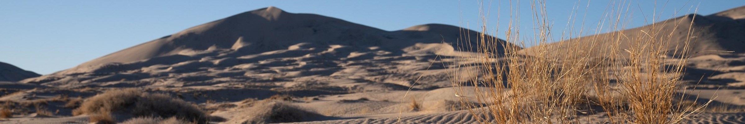
Mosaic of Desert Landscapes: Mojave National Preserve
Rippled sand dunes sing an eerie chorus. Cactus flowers bloom after a spring rain, jewels against buff-colored earth. Saltbush borders a dry lakebed, and countless Joshua tree limbs reach toward the sky. A bounty for the senses, Mojave is all these scenes and more.
Mojave National Preserve was established by the 1994 California Desert Protection Act. The 1.6-million-acre park encompasses much of the Mojave Desert, as well as transitional elements of the Great Basin and Sonoran deserts. About half of the park is congressionally designated wilderness. Wilderness areas, marked by signs, are open to hikers and horseback riders but off-limits to motor vehicles and bicycles.
Summer temperatures often exceed 100°F; yearly rainfall ranges 4-14 inches. Elevations range from 800 feet near Baker to 7,929 feet atop Clark Mountain. A spine of mountains bisects the park north to south. Cinder cones, lava beds, sand dunes, the Soda Dry Lake, and Cima Dome attest to the geological forces at work through the ages.
Many variables—elevation, moisture, soil composition, exposure to sunlight, shelter from the wind, and the effects of human habitation—create at least 30 identifiable habitats for plants and animals. The habitats do not have hard boundaries and often overlap; they are grouped below into general categories. You will encounter different habitats within a short distance of each other.
Mojave lacks many of the visitor facilities you might expect in a national park. This creates both inconveniences and opportunities. Nearby communities offer lodging and other services, so plan ahead. Be prepared to observe, explore, discover, and reflect.
Pinyon-Juniper Woodland
At higher elevations, particularly on north-facing slopes, pinyon and juniper trees cling to rocky, shallow soil. Look for this habitat in the Clark, Granite, New York, and Providence mountains. You can camp among these trees at Mid Hills Campground.
Pinyon nuts and juniper berries have long provided food for humans and wild animals. Ranchers built fences from junipers; you can still see remnants at abandoned homesteads.
This habitat has sagebrush, wildflowers like Indian paintbrush, goldenbush, and the Mojave prickly pear—one of several species of prickly pear found in the park. Also look for scrub jays, blue but not crested, and antelope ground squirrels.
Another clue to the high elevation is the bighorn—a wild sheep that feeds on grasses and other plants. They are best spotted by water sources. Hooves adapted to steep, rocky terrain allow them to escape predators like mountain lions.
Joshua Tree Woodland
Joshua trees tell you you're truly in Mojave country. Though they can grow 40-feet tall, they are not really trees but a species of yucca. They prefer flat areas or gradual inclines. The world's largest concentration of Joshua trees grows on the slope of Cima Dome near Teutonia Peak. Compare them with other yuccas that grow nearby.
Banana yuccas grow up to five feet and have long blue-green, curved spines. Mojave yuccas can reach a height of 20 feet.
One of Mojave's many lizard species, the desert night lizard, lives in decaying plant matter like downed Joshua trees. Despite its name this tiny lizard is active in the daytime but may hunt termites at night.
Insects, attracted by flowers of the threadleaf groundsel and Mojave mound cactus, become food for birds. Joshua tree woodlands support species like Scott's oriole and the American kestrel, a bird of prey.
Cactus-Yucca Scrub
Cactus, or mixed-desert, scrub includes the spiny succulents that fulfill the popular notion of "desert." Barrel cacti are prominent on south-facing slopes, like southwest of Hole-in-the-Wall. They germinate only in years with favorable rainfall, so barrel cacti growing near one another are usually of the same age. If you visit Mojave in spring you may see the desert plants in brilliant bloom.
The greenish gray Mojave rattlesnake blends in easily with this habitat. It is the most aggressive and highly venomous of the three kinds of rattlesnakes found in the park. This snake is most active at night and in early morning, so be careful where you place your hands and feet.
Early morning is a good time to spot a Gambel's quail feeding on cactus seeds and berries. These birds nest in abandoned nests of roadrunners, thrashers, and cactus wrens.
Desert Dunes
Prevailing winds carry sand from Soda Dry Lake, the Mojave River Sink, and Devil's Playground to the base of the Granite Mountains, creating dunes up to 700 feet high. At first the Kelso Dunes appear barren, but look closely: evening primrose, blazing star, and other plants find sufficient moisture. In favorable conditions dunes may be covered by Indian ricegrass.
Perhaps you will see a Mojave fringe-toed lizard skitter across the dunes. Look for tracks, especially of kangaroo rats and their main predators, kit foxes. Kit foxes are most often seen at dusk in open desert. They are about the size of a housecat with agility to match. Fur-covered toes give them traction in sand. Also look for the tracks of the sidewinder, which glides along with a rapid, two-part motion, barely touching the sand.
Creosote Bush Scrub
Strong-scented creosote bush and bursage dominate much of the park. These widely spaced shrubs cover low-lying expanses. Creosote bushes are said to be the world's oldest living things; some colonies here are 11,500 years old! Other plants in this zone are desert mallow, brittlebush, and hedgehog cactus. Of the several types of cholla here, the diamond (pencil) cholla is most abundant.
Roadrunners nest in this type of scrub. You may see one dart between areas of cover at up to 15 miles per hour. They can fly but seem to prefer running.
This is the home of the desert tortoise, which uses its sharp claws to dig nests in the sandy soil. Designated a threatened species, desert tortoises and their habitat are protected by federal law. Drive carefully and check under parked vehicles for tortoises. Watch for them along park roads in the early morning and after rainstorms, especially in spring and summer. Observe them from a distance; do not touch or bother them. Tortoises are susceptible to diseases that can be transmitted through human contact.
Desert Wash
Washes generally flow intermittently after heavy rains—a feast or famine of water that creates specific plant communities. Roadside water runoff can also create a miniature habitat of its own. Sacred datura, also called jimson weed or thorn apple, thrives in this water runoff, making the plant stand out along roads.
Unlike the sparse vegetation in most of the park, plantlife in washes is lush and deep-rooted. Plants range from shrubs like the catclaw acacia, cheesebush, four-wing saltbush, and bush senecio to taller trees like desert willow and Cottonwood.
Look on the branches of the shrubby catclaw acacia for clumps of desert mistletoe, a parasitic plant. Mistletoe attracts phainopepla, a small, tufted black bird that eats—and disperses—its berries. Water attracts many birds, like migratory finches, orioles, and tanagers, and other animals like the red-spotted toad. The blacktail jackrabbit, recognized by large, black-tipped ears and a black-topped tail, is generally nocturnal. As fast as jackrabbits are they may not be able to outrun a coyote, one of their few natural predators in this region.
The Mojave Road
Skirting mountains and other natural barriers, the Mojave Road follows the most natural travel corridor through the desert. It runs east-west from the Colorado River to Camp Cady, near Barstow, roughly bisecting the park. The trail is still visible, especially where it intersects modern roads, and is popular with hikers and four-wheel-drive enthusiasts.
American Indians like the Paiute, Mojave, and Chemehuevi used the corridor for travel and trade. They guided Spanish explorers along the trail in the 1770s. As westward exploration and settlement increased during the 1800s, the US Army improved the road and established outposts for the safety of supply wagons, mail, and travelers. Fort Piute, built to protect Piute Spring, dates from the 1860s. Not everyone passed through; some found ways to make a living from the desert's natural resources. The coming of the railroad in the 1890s made mining and ranching profitable for a time—and immediately replaced the Mojave Road as the preferred method of travel through the desert.
Plan Your Visit
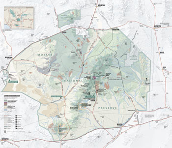 (click for larger map) |
Mojave National Preserve is in southeastern California between I-15 and I-40. The nearest large cities are Las Vegas, NV, and Barstow, CA. To make the most of your visit, stop first at the Kelso Depot Museum or the Hole-in-the-Wall Information Center. More details are on the park website.
Camping Two small campgrounds open year-round, first-come, first-served (fee), have pit toilets, picnic tables, fire rings, trash cans, and drinking water. The road to Mid Hills Campground is not recommended for trailers or large RVs. Black Canyon is only for group or equestrian camping—reservations required. Backcountry and roadside camping are allowed in previously used areas.
Wilderness Nearly half of the park is designated wilderness. Please respect all wilderness boundary markers. Motorized and mechanized vehicles are prohibited in these areas, but we encourage you to explore on foot and horseback. The park has trails of all varieties. Before you set out, read and heed "For a Safe Visit".
Regulations Off-road driving is prohibited. • Off-highway vehicles (OHV) must be street legal in accordance with California Department of Motor Vehicles (DMV) requirements. • Federal law protects all plants, animals, rocks, and cultural features. • Pets must be on a leash at all times. • Licensed hunting per California Fish and Wildlife regulations is permitted, but target shooting and plinking are prohibited.
Accessibility We strive to make our facilities, services, and programs accessible to all. For information go to a visitor center, ask a ranger, call, or check our website.
For a Safe Visit
• Check the park website for up-to-date alerts.
• Drive with caution. Rough roads may exist. Ask about unpaved road
conditions before traveling. Many unpaved roads require high-clearance or 4x4
vehicles.
• Carry and drink plenty of water.
• Cell phone and GPS service may be non-existent or unreliable.
• Hidden dangers exist throughout the preserve, including abandoned mines
and wells. Use caution in and around unmaintained structures.
• No fuel or groceries are available inside the preserve.
Source: NPS Brochure (2017)
|
Establishment Mojave National Preserve — October 31, 1994 |
For More Information Please Visit The  OFFICIAL NPS WEBSITE |
Documents
Accessibility Self-Evaluation and Transition Plan Overview, Mojave National Preserve, California (October 2017)
An Oasis for Railroaders in the Mojave: The History and Architecture of the Los Angeles and Salt Lake Railroad Depot, Restaurant and Employees' Hotel at Kelso, California, on the Union Pacific System (Gordon Chappell, Robert L. Carper, Harold Brown, Steve Hart, Bridget Wanderer, Andrew M. Roberts, Charles Svoboda and Steven E. Daron, January 1998)
California's National Parks in Peril: The Threats of Climate Disruption (Stephen Saunders and Tom Easley, ©The Rocky Mountain Climate Organization and Natural Resources Defense Council, October 2010, all rights reserved)
Condition Assessment and Treatment Recommendations: Live Oak and Evening Star Mines, Mojave National Preserve, San Bernardino County, California (University of Vermont School of Engineering, February 2014)
Cultural Landscapes Inventory: Rock Springs Land and Cattle Company (2007)
Desert Landforms and Surface Processes in the Mojave National Preserve and Vicinity USGS Open-File Report 2004-1007 (Philip Stoffer, 2004)
Enjoy the View — Visual Resources Inventory Inventory Report: Mojave National Preserve NPS Natural Resource Report NPS/MOJA/NRR–2016/1322 (Mark Meyer and Debra Hughson, October 2016)
Foundation Document, Mojave National Preserve, California (Draft, 2012)
Foundation Document, Mojave National Preserve, California (June 2013)
Foundation Document Overview, Mojave National Preserve, California (July 2014)
From Neglected Space To Protected Place: An Administrative History of Mojave National Preserve (HTML edition) (Eric Charles Nystrom, March 2003)
General Management Plan, Mojave National Preserve (April 2002)
Historic Furnishings Report: Kelso Depot (Sarah H. Heald, 2001)
Historic Structure Report: Kelso Depot: An Oasis for Railroaders in the Mojave (Gordon Chappell, Robert L. Carper, Harold Brown, Steve Hart, Bridget Wanderer, Andrew M. Roberts, Charles Svoboda and Steven E. Daron, January 1998)
History of Water Development for Hole-In-The-Wall Area, Mojave National Preserve NPS Technical Report NPS/NRWRD/NRTR-2002/298 (William Werrell and Paul Summers, July 2002)
Inventory of Amphibians and Reptiles at Mojave National Preserve USGS Open-File Report 2007-1109 (Trevor B. Persons and Erika M. Nowak, 2007)
Junior Ranger, Mojave National Preserve (Date Unknown; for reference purposes only)
Long-Range Interpretive Plan, Mojave National Preserve (2004)
Minerals in the East Mojave National Scenic Area, California: A Minerals Investigation, Volume I MLA 6-90 (August 1990, revised November 28, 1990)
Minerals in the East Mojave National Scenic Area, California: An Economic Analysis, Volume II MLA 6-90 (August 1990, revised November 28, 1990)
Mojave Desert Network Integrated Upland Monitoring: 2012 Pilot Study for Mojave National Preserve NPS Natural Resource Technical Report NPS/MOJN/NRTR—2013/827 (Jean J. Pan and Nita Tallent, November 2013)
Mojave Desert Network Inventory and Monitoring Selected Large Springs: Pakoon Springs 2015-2016 Benthic Macroinvertebrate data NPS Natural Resource Data Series NPS/MOJN/NRDS—2018/1147 (Michael H. Steiner, January 2018)
Mojave Desert Network Selected Large Springs Pilot Study: Texas Spring Springsnail and Benthic Macroinvertebrate Data NPS Natural Resource Data Series NPS/MOJN/NRDS—2014/703 (Geoff J. M. Moret, Christopher C. Caudill and Mary L. Levandowski, September 2014)
Monitoring Ecosystem Quality and Function in Arid Settings of the Mojave Desert USGS Scientific Investigation Report 2008-5064 (Jayne Belnap, Robert H. Webb, Mark E. Miller, David M. Miller, Lelsey A. DeFalco, Philip A. Medica, Matthew L. Brooks, Todd C. Esque and Dave Bedford, 2008)
Movement models and simulation reveal highway impacts and mitigation opportunities for a metapopulation-distributed species (Christina M. Aiello, Nathan L. Galloway, Paige R. Prentice, Neal W. Darby, Debra Hughson and Clinton W. Epps, extract from Landscape Ecology, 2023)
Museum Management Plan, Mojave National Preserve (Bob Bryson, Lisbit Bailey, Steve Floray, Diane Nicholson and Melanie Spoo, April 2007)
National Register of Historic Places Nomination Form
Kelso Depot, Restaurant and Employees Hotel (Harlan D. Unrau, June 19, 2000)
Natural Resource Condition Assessments for Six Parks in the Mojave Desert Network NPS Natural Resource Report NPS/MOJN/NRR-2019/1959 (Erica Fleishman, Christine Albano, Bethany A. Bradley, Tyler G. Creech, Caroline Curtis, Brett G. Dickson, Clinton W. Epps, Ericka E. Hegeman, Cerissa Hoglander, Matthias Leu, Nicole Shaw, Mark W. Schwartz, Anthony VanCuren and Luke Z. Zachmann, August 2019)
Paleontological Resource Inventory (Public Version), Mojave National Preserve NPS Natural Resource Report NPS/MOJA/NRR-2023/2541 (Emily Johnson, Sofia Andeskie, Justin S. Tweet and Vincent L. Santucci, July 2023)
Park Newspaper (Visitor Guide/Parks News & Guide):
1998-1999: 1998/1999 •
2001: Issue 3 •
2005: Fall •
2006: Fall •
2007: Spring • Fall •
2008: Spring • Fall •
2009: Spring • Fall •
2010: Spring • Fall •
2011: Spring • Fall •
2012: Spring • Fall •
2013: Spring •
2014 • 2015-2016
Persistence and turnover in desert plant communities during a 37-yr period of land use and climate change (Scott R. Abella, Ross J. Guida, Chris L. Roberts, Carrie M. Norman and James S. Holland, extract from Ecological Monograph, Vol. 89 No. 4, November 2019, ©Ecological Society of America)
Reconstructing the Water Level Record at MC Spring since 1990: Mojave National Preserve NPS Natural Resource Report NPS/MOJN/NRR—2015/1006 (Jennifer L. Bailard and Geoffrey J. M. Moret, August 2015)
Report on a Workshop to Revisit the Mohave Tui Chub Recovery Plan and a Management Action Plan (Debra Hughson and Danette Woo, April 15, 2004)
Science Newsletter: Mojave National Preserve (Sweeney Granite Mountains Desert Research Center) (2009-2021)
Support for Research Proposal on Fire and Invasive Annual Grass in Western Ecosystems: Memo (April 25, 2000)
The Changing Face of the East Mojave Desert: Abstracts from the 2001 Desert Symposium (Robert E. Reynolds, ed., April 2001)
The Oasis (Mojave Desert Network)
2022: Spring
Treatment Report: Stabilization of the Live Oak Mine, Mojave National Preserve, San Bernardino County, California (University of Vermont School of Engineering, April 2015)
Vegetation Classification at Lake Mead National Recreation Area, Mojave National Preserve, Castle Mountains National Monument, and Death Valley National Park: Final Report (Revised with Cost Estimate) NPS Natural Resource Report NPS/MOJN/NRR-2020/2178 (Julie M. Evens, Kendra G. Sikes and Jaime S. Ratchford, October 2020)
Visitor Study: Spring 1997, Mojave National Preserve Visitor Services Project Report 94 (Margaret Littlejohn, November 1997)
Visitor Study—Appendix: Spring 1997, Mojave National Preserve Visitor Services Project Report 94 (Margaret Littlejohn, November 1997)
Visitor Study—Appendix: Fall 2003, Mojave National Preserve Visitor Services Project Report 151 (Yen Le, Margaret Littlejohn and Steven J. Hollenhorst, July 2004)
Wilderness Review in the East Mojave Scenic Area, California (©Stephen Roderick Mark, Master's Thesis Southern Oregon State College, 1984)
moja/index.htm
Last Updated: 01-Jan-2025