|
Mount Rainier
Environment, Prehistory & Archaeology of Mount Rainier National Park, Washington |

|
Chapter 4:
THE 1995 MOUNT RAINIER ARCHEOLOGICAL RECONNAISSANCE
By the end of 1990, at least 34 possible prehistoric sites or isolated finds had been reported for Mount Rainier National Park. Site accounts were present in a variety of books, inventory reports, internal memos and museum notes. Few of these reports, however, were documented formally or integrated into an organized database for the Park. Indeed, all but eight of the field sites (FS) and all of the isolated finds (IF) included in Tables and Figures 3.1 through 3.3 in Chapter 3 remained unverified. Some of the unverified reports included map locations; many did not. Some of the artifacts found their way into museum storage at Longmire; others disappeared to individual or institutional collections. In short, Mount Rainier prehistoric site data and cultural remains were scattered. At the beginning of the present project, then, only eight sites were documented with the Washington Office of Archaeology and Historic Preservation (OAHP)–all but one through efforts taking place from 1986 through 1990. McClure's (1990) research, and perhaps Bergland's (1986) earlier investigations, were the only serious attempts to impose order on the Park's archaeological record.
The present project was intended to expand and impose order on the archaeological record as it appeared in the early 1990s. It was awarded formally to the International Archaeological Research Institute, Inc. (IARII) in 1994 (Park Service Contract 1443-CX9000-93-020, Task 5). Fieldwork was completed in 1995. Primary project goals were to 1) consolidate existing prehistoric site and isolate reports; 2) locate and reevaluate or document as many of these localities as practical; and 3) expand the site database through new survey structured to widely sample Park landforms and environmental zones. In concert with environmental research, these data were to be used to generate environmental and site stratification expectations discussed in Chapter 2 and continued in this and the following chapter.
The preceding chapter consolidated site and isolate information available at the beginning of the present project (also see Appendix A). [24] The sections below describe field procedures, and summarize and interpret various aspects of the results of the 1995 effort. The concluding section, coauthored by Stephen Hamilton, presents lithic analytical results and implications for intersite variation in the current Mount Rainier sample. References should be made to this report's companion 1995 Reconnaissance Data volume (Burtchard and Hamilton 1998) for site-specific information.
SITE VERIFICATION AND RECONNAISSANCE
PROCEDURES
Reconnaissance fieldwork was completed between August 7 and September 21, 1995 by Stephen Hamilton and the author. Assistance was provided by Park archaeologist Gregg Sullivan and IARII's Randall Schalk with additional help from Emma Krzeminski and Michelle Morseth. Because of limited survey time and logistical difficulty inherent in conducting fieldwork around Mount Rainier, the project emphasized documentation of prehistoric archaeological remains. Locations of historic period debris were noted in the field, but only two of the most substantial historical complexes were documented formally as archaeological sites (FS 95-02 [45PI427] and FS 95-09 [45PI428]) and described in the 1995 Reconnaissance Data volume (Burtchard and Hamilton 1998).
Recognizing our inability to examine all previously reported finds and conduct a meaningful level of new site survey within a six week field effort, the reevaluation/site verification portion of the project emphasized reported multiple artifact concentrations for which at least approximate map data were available. Our intent was to focus on prehistoric remains most plausibly associated with sustained or redundant prehistoric use; that is, the most probable site rather than simpler isolated find localities. These efforts resulted in reevaluation of five of the eight previously documented sites; formal documentation of four previously reported but unverified sites, and documentation as isolates of seven previously reported finds. These 16 verified or reevaluated sites and isolates, plus the three previously documented but not reevaluated sites, are identified by the field site (FS) and isolated find (IF) prefixes on Tables 3.1 through 3.3 in Chapter 3.
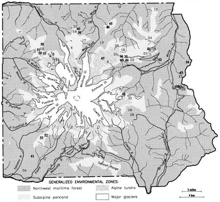
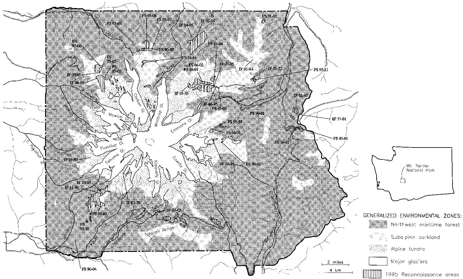
New field reconnaissance was completed for approximately 3,550 Park acres. Inventory areas were divided among four quadrants; selected to maximize landform variability, open sediment exposure and access efficiency (see fold out Figure 4.2). In effect, this focused approximately 70% of the new survey on alpine tundra and subalpine parklands with open to patchy forest cover and substantial moderate gradient terrain. [25] Because such areas also tend to be associated with relatively high densities of exploitable floral and faunal resources (e.g., goats, elk, marmots, deer, bears, game birds, huckleberries, alpine lilies, etc.), it is likely that these zones also were among the most heavily used throughout the prehistoric past. [26]
To accommodate small crew size and site discovery difficulties posed by variably dense ground cover and repeated volcanic deposits, particular attention was given to exposed mineral sediments, erosion scars and potential rockshelter locations at cliff bases. The term reconnaissance used to characterize this project throughout the report reflects the extensive character of the effort as opposed to more intensive archaeological survey with team members walking at closely spaced, regular transect intervals.
Basic documentation procedures were identical for both reevaluated and newly located sites. After discovery of the initial artifact or feature, intensive survey was conducted outward from that point until no additional materials could be located. Pin flags were used to mark artifacts and features. Localities with three or more visible artifacts were documented as archeological sites. Localities for which only one or two artifacts could be found were recorded as isolated finds. Descriptive site and local environmental data were entered onto forms adapted from and approved by the Washington OAHP. An abbreviated form was used to record isolated localities. Universal transmercator (UTM) coordinates for datum points at both sites and isolated finds were obtained using a global positioning system (GPS) receiver. These location points later were entered into the Park's geographic information system (GIS) and plotted onto the color Park quadrant maps included as Figures 2.10 through 2.13 in Chapter 2. Sketch maps illustrating artifact and cultural feature distributions relative to local terrain features were prepared for site localities only. Both sites and isolates were plotted onto USGS 7.5 minute topographic quad maps. Finally, sites and prominent terrain features were photographed and cataloged to the appropriate sites. Full descriptive results are included in the 1995 Reconnaissance Data volume (Burtchard and Hamilton 1998), and are on file at OAHP and at Mount Rainier National Park headquarters in Longmire.
In order to provide as objective a descriptive system as practical, a field lithic assemblage inventory was completed for all prehistoric sites and isolates investigated in 1995. Our intent was not only to develop a replicable recording system, but to provide quantitative means to isolate site variability on the basis of surface evident remains. The basic procedure employed for each lithic locality was to flag artifacts as noted above, then investigate all flagged items by isolating artifact type (debitage, core or tool/preform), then tally a set of technical attributes by raw material (see Appendix B). When appropriate, comments on specific artifacts, assemblage character, visibility and other variables were recorded. Artifacts and preforms also were drawn and photographed. Site specific tabular results are included on individual site forms and in the Site Data volume. General implications for use of the Park are discussed in a later section of this chapter.
In sum, the 1995 field research was geared both toward consolidating the Park's preexisting suite of prehistoric sites and expanding it as practical within the bounds of a limited field effort. Special note should be made regarding the character of the present inventory. While we have confidence that the Mount Rainier reconnaissance was thorough and provides useful new site distribution information, it is important to recognize that it does not constitute full or final survey of the landforms inspected. Almost certainly intensive survey, particularly if supplemented by subsurface sampling techniques, will identify additional prehistoric sites. For the present, however, reconnaissance data provide a preliminary view of site distribution on these landscapes and expands the existing site database in a manner that allows us to consider site distribution patterns in the Park.
THE NEW PICTURE, REPORTED PREHISTORIC SITES
AND ISOLATES 1991-1995
During the present reconnaissance, 28 new sites, isolates, and well substantiated but unverified sites were added to the total documented through 1990. Table 4.1 lists reported finds, sources and site or isolate number. Map Figure 4.1 shows the count of 62 reported prehistoric places, both documented and unverified, in Mount Rainier National Park at the close of 1995.
|
| Figure 4.1 Mount Rainier Prehistoric Localities Reported through 1995 Formally Documented Archaeological Sites in Mount Rainier National Park |
Table 4.1 Sites and Isolates, 1991-1995 (also see Appendix A)
| No. | Date | Reported Find | Source | Comment |
| 35 | 1995 | Lithic scatter | Burtchard & Hamilton 1998 | FS 95-03; Yakama Park, Sunrise Ridge |
| 36 | 1995 | Lithic scatter | " | FS 95-04; Yakama Park, Sunrise Ridge |
| 37 | 1995 | Lithic scatter | Carl Fabiani, pers com. 1995 | FS 95-05; Mist Park |
| 38 | 1995 | Lithic scatter | Burtchard & Hamilton 1998 | FS 95-06; Mother Mountain |
| 39 | 1995 | Lithic scatter | " | FS 95-07; Windy Gap |
| 40 | 1995 | Lithic scatter | " | FS 95-08; Windy Gap |
| 41 | 1995 | Lithic scatter | " | FS 95-10; Forgotten Creek (N of Kautz Creek) |
| 42 | 1995 | Lithic scatter | " | FS 95-11; Sunrise Lake |
| 43 | 1995 | Interior chert flake | " | IF 01-95; Deadwood Lakes |
| 44 | 1995 | Basalt flake | " | IF 02-95; Summerland |
| 45 | 1995 | Obsidian flake, basalt uniface | " | IF 03-95; Grand Park |
| 46 | 1995 | Chalcedony interior flake | " | IF 04-95; Grand Park |
| 47 | 1995 | Biface & uniface frags. | " | IF 05-95; Upper Berkeley Basin |
| 48 | 1995 | Chalcedony flake & core | " | IF 06-95; Yakama Park, Sunrise Ridge |
| 49 | 1995 | Chalcedony interior flake | " | IF 07-95; Yakama Park, Sunrise Ridge |
| 50 | 1995 | Jasper shatter fragment | " | IF 08-95; Spray Park |
| 51 | 1995 | Tabular stone manuport | " | IF 09-95; Spray Park |
| 52 | 1995 | River cobble manuports | " | IF 10-95; Copper Mountain |
| 53 | 1995 | Basalt reduction flake | " | IF 11-95; Mirror Lakes |
| 54 | 1995 | Chert thinning flake | Pam Cox 1995 | Unverified locality; Crystal Lakes |
| 55 | 1995 | Jasper projectile point | Carl & Denise Fabiani 1995 | Unverified; ridgetop near Tolmie Peak |
| 56 | 1995 | Jasper projectile point | Carl & Denise Fabiani 1995 | Unverified; Howard Peak |
| 57 | 1995 | Projectile point, hearsay accounts of Indian baskets | Carl & Denise Fabiani 1995 | Unverified; west end of Eunice Lake |
| 58 | 1995 | Point fragment and flakes | Carl & Denise Fabiani 1995 | Unverified; fire trail on ridgetop south of Mowich Lake near Park boundary |
| 59 | 1995 | Lithic scatter | Carl & Denise Fabiani 1995 | Unverified; ridge between Tyee Peak and Windy Gap |
| 60 | 1995 | Two flakes | Carl & Denise Fabiani 1995 | Unverified; trail east of Golden Lakes R.S. |
| 61 | 1995 | Two flakes | Carl & Denise Fabiani 1995 | Unverified; trail along top of Sunrise Ridge |
| 62 | 1995 | Yakama Trail Segment | C. Fabiani 1995, J. Morrison 1995, and R. Drake 1996 | Undocumented; eastern and southern flank of Sunrise Ridge |
Note: Two historic period sites (FS 95-02 and FS 95-11) were also documented during the 1995 reconnaissance. These sites are described in detail in Section 2 and included on Figure 4.2 below. In addition, two culturally peeled cedar trees were reported by Janet Liddle (pers. com. 1996) after compiling the information included here. One tree is situated on the southeast Park boundary north of Carlton Creek; the second north of Skate Creek Road, west of Bear Prairie, north of the Nisqually River. | ||||
Twenty-four of the 62 sites and isolated finds reported through 1995 and shown on Figure 4.1 have not been verified in the field or documented in a formal fashion. They are included here to help illustrate the Park's first slow then rapidly growing archaeological record, to show the subalpine and alpine bias in the location of prehistoric use areas, and to provide an organized database for continuing verification survey efforts. Clearly, the site database will continue to grow as verbal accounts and historic period cultural remains are added to the list, and new survey adds as yet unknown cultural remains.
As noted above, eight prehistoric sites had been formally documented in Mount Rainier National Park at the beginning of the present project. Five of these were reevaluated and documentation updated in 1995. In addition, 11 previously reported, but undocumented, sites (n=4) and isolates (n=7) were recorded during the current project. Newly documented archaeological localities include eight new prehistoric sites, two historic period sites and 11 isolated finds. [27] Combined with reevaluated sites, these results bring to 40 the number of formally documented archaeological localities in Mount Rainier National Park. Fold-out Figure 4.2 shows 1995 reconnaissance areas and the current set of formally documented sites and isolates in Mount Rainier National Park. Full descriptive documentation for these sites is included in Burtchard and Hamilton (1998). A tabular summary of results is included as Table 4.2.
It is important to emphasize, that sites and isolated finds included here represent a beginning effort at documenting the Park's archaeological record. The site count will increase further as other localities are investigated, as subsurface techniques are added to surface reconnaissance efforts, and as overall sample areas increase. Please note, too, that due to this study's focus on prehistoric remains, the results substantially under-represent the Park's historic period archaeological record. Finally, additional hearsay localities not reflected in written reports probably will be added as efforts to elicit such information from knowledgeable individuals continue.
The above considerations notwithstanding, the current sample reasonably characterizes the general distribution of prehistoric archaeological remains in Mount Rainier National Park. Many of the documented sites and isolates were found over a long period of time by individuals whose observations accommodate a variety of locations, terrain and environmental circumstances. Accordingly, sampled terrain is widely dispersed across the Park landforms and environmental zones. Prehistoric site distribution, however, is not comparably dispersed. As predicted by Smith's (1964) over 30 years ago, the tendency toward location of prehistoric remains in subalpine to alpine settings is clear and represented on all sides of the mountain.
Patterns appear in other aspects of the archaeological record as well. In the sections that follow, extant Mount Rainier data are reviewed and related to implications for long-term land-use practices in the Park. Results of field lithic analyses are considered first; emphasizing artifact classes, technological attributes and raw materials. The lithic assemblage is then discussed in terms of its relevance to functional site distinctions and temporal implications. The final section of the chapter builds on these analyses to propose a nine-part site type model for the park. The final section also considers site type and distribution patterns in relation to a series of specific environmental variables.
Table 4.2 Mount Rainier 1995 Archaeological Site and Isolated Find Summary
| Site/Isolate | Site Name | Location / Context | Site | Type Comment |
| 45PI043 FS 63-01 |
Fryingpan Rockshelter | NE quadrant near Fryingpan Creek / Forested valley floor setting | Shallow prehistoric cave shelter | [Documented 1963, Reevaluated 1995] Large north-facing rock overhang with prehistoric remains. Tested in 1964 by D. Rice (1965). Collections at WSU. Recommend excavation to improve faunal and temporal data, and potentially add floral information. |
| 45PI407 FS 86-01 |
Frozen Lake Site | NE quadrant W of Frozen Lake / Alpine tundra | Prehistoric lithic scatter | [Documented 1986, Reevaluated 1991 & 1995] Primary reduction site on exposed ridge west of the lake. Debris predominantly red jasper, with chalcedony and basalt. Materials on site and in MORA collection. Several collected bifaces illustrated, but lost. Tephra and debitage relationship suggests post 2,300 B.P. date. |
| 45PI303 FS 86-02 |
Berkeley Rockshelter | NE quadrant near Lodi Creek in Berkeley Basin / Subalpine parkland | Prehistoric & historic period rockshelter | [Documented 1986] Early 1900s historical artifacts and stratified prehistoric debris in double talus boulder rockshelter. Tested 1987 by Bergland (1988).14C dated 290 & 1,070 B.P. |
| 45PI406 FS 88-01 |
Tipsoo Lakes Site | Boundary NE & SE quadrants / Lakeside near subalpine parkland | Prehistoric lithic scatter | [Documented 1988, Reevaluated 1995] Moderate density lithic scatter concentrated from picnic and parking area to western end of lakes. Mixed late stage lithic debris. NPS tests in progress suggest shallow subsurface deposits. Temporal range presently unknown. |
| 45PI408 FS 90-01 |
Sunrise Ridge Borrow Pit Site | NE quadrant on Sunrise Ridge / Forested SW facing side slope bench | Prehistoric lithic scatter & modern borrow pit | [Documented 1990, Reevaluated 1995] Extensive lithic scatter with ground stone on or near Yakama trail to Sunrise Ridge. Tephra stratigraphy suggests 4,500-2,300 B.P. date. Damaged by road fill & tree planting excavation. Site erosion ongoing. Recommend data recovery excavation to establish site content, function and temporal range. |
| 45PI409 FS 90-02 |
Sarvant Glaciers Site | SE quadrant / Alpine tundra | Prehistoric lithic scatter | [Documented 1990] Low density scatter with arrow point & bifaces. May be a single use site. |
| 45PI410 FS 90-03 |
Windy Gap Site | NW quadrant on ridge saddle / Subalpine parkland | Prehistoric lithic scatter | [Documented 1990, Reevaluated 1995] Single source chalcedony debitage and dart-sized hafted biface. May be a single use site. |
| 45PI411 FS 90-04 |
Tum Tum Peak Quarry Site | SW quadrant on forested ridge saddle | Prehistoric chert procurement | [Documented 1990] Interior chert flakes percussion struck from several parent boulders. |
| 45PI438 FS 71-01 |
Buck Lake Site (a.k.a. Fawn Ridge) | NE quadrant on ridge overlooking lake / Subalpine parkland | Prehistoric lithic scatter & possible historic component | [Reported 1971, Documented 1995] Multiple lithic concentrations on ridge and bench landforms NE of Buck Lake. Probable sustained and/or reused site. Recommend test procedures to better establish site parameters, and survey of surrounding elevated ridge system toward Palisade Lakes. Buck Lake also may be suitable for paleoenvironmental core extraction. |
| 45PI433 FS 72-02 |
Mt. Pleasant Rockshelter | NW quadrant at cliff-talus interface/ Subalpine parkland | Shallow prehistoric & historic period cave shelter | [Reported 1972, Documented 1995] East facing shelter above Mist Park at the northern edge of Spray Park. Contains tertiary interior flakes and historic period materials including wood and what appear to be small detonator caps. |
| 45PI437 FS 74-01 |
Vernal Park Rockshelter | NW quadrant under boulder at talus base / Subalpine parkland | Prehistoric & historic period shelter | [Reported 1974, Documented 1995] Boulder forms a natural overhang on the SE side. Large, low interior space partially enclosed by stacked rock walls. Chalcedony & chert flakes found in 1974. Walls appear to be historical. |
| 45PI426 FS 95-01 |
Tipsoo Two | Boundary NE & SE quadrants /Lakeside near subalpine parkland | Prehistoric lithic scatter | Seven tertiary interior argilite flakes exposed in trail and under viewing bench. Appear to reflect a single reduction event. |
| 45PI427 FS 95-02 |
Camp Garcia (Historic Site) | Boundary NE & SE quadrants / Forested terrace above Fryingpan Creek | Historic period camp/ Maintenance area | A series of excavated tent platforms, privy & dump pits, central area with structural elements, and water by-pass ditch. Early to mid 1900s. Possible CCC camp or trail construction station. |
| 45PI436 FS 95-03 |
Upper White River Trail Site | NE quadrant / Subalpine parkland | Low density lithic scatter | Chalcedony and chert late stage reduction flakes with one quartzite manuport on rodent reworked sediments. Appears to predate pre-date Mount Rainier C tephra (i.e., >2300 B.P.) |
| 45PI435 FS 95-04 |
Yakama Park Rim | NE quadrant / Subalpine parkland | Low density lithic scatter | Chalcedony and chert late stage reduction flakes on ridge top overlooking White River canyon. |
| 45PI432 FS 95-05 |
Mist Park Overlook Site | NW quadrant / Subalpine parkland | Low density lithic scatter | Interior chert and fine-grained basalt flakes with associated bird gastroliths (gizzard stones); all exposed in social trail/picnic area at Spray Park rim overlooking Mist Park to the north. |
| 45PI431 FS 95-06 |
Mother Mtn. Lake 5554 Site | NW quadrant / Subalpine parkland | Lithic Scatter | Expedient polyhedral core and early stage gray chert reduction flakes. May be a single reduction event. |
| 45PI434 FS 95-07 |
Windy Gap Two | NW quadrant / on pass saddle in subalpine parkland | Lithic Scatter | Secondary to tertiary reddish brown chert manufacturing flakes; two with cortical facies. Probable manufacturing site similar to Windy Gap One (FS 90-03). |
| 45PI430 FS 95-08 |
Middle Spunkwush Lake Site | NW quadrant / Lakeside setting in subalpine parkland | Low density lithic scatter | Mid to late stage reduction of multiple chert material types scattered on rocky ridge west of small lake. Multiple materials suggest repeated low intensity use of the locality. |
| 45PI428 FS 95-09 |
Devils' Dream Cache & Cut (Historic Site) | SW quadrant / in Silver Fir - Alaska Cedar Forest | Cedar cutting area, historic cache, and log stockpile | Small rockshelter with circa 1915 cooking gear adjacent to area with multiple ax and saw cut cedars. Skid trail to Devil's Dream Creek. Probable associated stockpile near Squaw Lake. |
| 45PI429 FS 95-10 |
Forgotten Creek Site | SW quadrant / Headwater spring in patchy forest-beargrass zone | Lithic scatter | Mixed interior reduction flakes, dart-sized projectile point base, and edge battered milling stone located on flat ground near a perennial spring. Recommend testing and intensive survey of adjacent ridge and low gradient slopes. |
| 45PI439 FS 95-11 |
Little Sunrise Lake Site | NE quadrant / Lakeside setting in subalpine parkland | Lithic scatter | Late stage red jasper, chalcedony and grayish red chert exposed in game trail on small ridge adjacent to smaller Sunrise Lake. Pecked and battered stone base with minor grinding wear also present. Recommend intensive survey of Sunrise Lake vicinity and of parkland settings north to Buck Lake. |
| IF 02-63 | Bench Lake Trail head | Boundary SW & SE quadrant / Brushy forest cover | Dart point | [Identified 1963, Reevaluated 1995] Single leaf shaped (Cascade) projectile point, apparently at contact below St. Helen's-Yn tephra (circa 4000-5800 B.P.). |
| IF 01-68 | Yellowstone Cliffs | NW quadrant / Forested side slope bench | Arrow point | [Identified 1968, Reevaluated 1995] Large chalcedony corner notched triangular point and single flake on large side slope bench below Yellowstone Cliffs. Recommend subsurface testing to establish possible site parameters. |
| IF 01-70 (Unverified) |
Success Cleaver Isolates | SW quadrant / Alpine | Biface & Arrow point | Triangular basalt biface tip and chalcedony corner notched arrow-sized point. Reported by Jan Henderson, "lying on sandy pumice." |
| IF 01-72 | Sunrise Creek | NE quadrant / Subalpine parkland | Biface tip & flake | [Identified 1972, Reevaluated 1995] Chalcedony hafted biface tip and flake in/near Sunrise Creek near bridge. Probably displaced from general area use, especially FS 95-11. |
| IF 01-77 | Deadwood Lakes Pass | NE quadrant / Pass saddle, subalpine parkland | Flake (?) | [Identified 1977, Reevaluated 1995] Prehistoric item (not described) in trail at crest of the pass between Deadwood Creek and Rainier Fork of the American River. No additional materials found during reevaluation. |
| IF 01-84 (Unverified) |
Upper Palisades Trail Isolate | NE quadrant / Subalpine | Lanceolate Arrow point | Lanceolate gray chert projectile point with slight stem; 28 x 10 mm with 6 mm haft width. Found by Wendy Burman. |
| IF 01-87 (Unverified) |
Tokaloo Trail Isolate | SW quadrant / Alpine | Probable Dart Point | Triangular, contracting stem projectile point; 39 x 19 mm with circa 8 mm haft width. Red jasper. In trail to Tokaloo Rock at 6700 ft Reported by Chris Jensen. |
| IF 01-95 | Lower Deadwood Lake | NE quadrant / Lakeside subalpine parkland | Flake | Tertiary interior chert flake. On, but possibly reworked from below, Mount Rainier C tephra (> 2300 B.P.). Recommended subsurface testing to determine possible site presence. |
| IF 02-95 | Summerland | Boundary NE & SE quadrants / alpinesubalpine margin | Flake | Medium grained greenish-gray basalt flake contrasts with immediately available raw materials. Possible source material up slope near Panhandle Gap. |
| IF 03-95 | Grand Park One | NW quadrant / Subalpine parkland | Thinning flake & unifacial tool fragment | Obsidian biface thinning flake and unifacially worked andesite flake–possible awl fragment– in seasonal flood channel. Recommend subsurface investigation of surrounding terrain. |
| IF 04-95 | Grand Park Two | NW quadrant / Subalpine parkland | Flake | Chalcedony interior flake. May be reworked from below Mount Rainier C tephra. Recommend subsurface testing of surrounding terrain. |
| IF 05-95 | Upper Berkeley Park | NE quadrant / alpine-subalpine margin | Biface & uniface flake fragments | Chalcedony potlid fragment from probable bifacial tool and unifacially retouched chert flake. Near Lodi Creek headwaters at extreme upper Berkeley Park. Recommend subsurface testing of nearby side slope benches. |
| IF 06-95 | Yakama Park One | NE quadrant / Subalpine parkland | Flake & core fragment | Chalcedony flake and core fragment, possibly reworked from below Mount Rainier C tephra. Spatially associated with FS 95-3 & 4 and Is 7-95. Recommend testing surrounding terrain to better establish possible site parameters. |
| IF 07-95 | Yakama Park Two | NE quadrant / Subalpine parkland | Flake | Chalcedony flake on ridge top overlooking Is 6-95 and immediately east of FS 95-4. As above, general area should be investigated more thoroughly to establish possible site parameters. |
| IF 08-95 | Spray Park Shatter | NW quadrant / Subalpine parkland | Manuport | Large brownish red jasper shatter fragment on deflated flat parkland surface above Mt. Pleasant Rockshelter (FS 95-5). |
| IF 09-95 | Spray Park Slab | NW quadrant / Subalpine parkland | Manuport | Subangular, tabular, course grained metasediment manuport on small side slope bench above Mt. Pleasant Rockshelter (FS 95-5). Possible abrading stone. |
| IF 10-95 | Copper Mtn. Cobbles | SE quadrant / Alpine-subalpine boundary | Cobble manuports | Two river rounded cobble manuports among subangular natural elements on top of Copper Mtn. No obvious battering or other wear. |
| IF 11-95 | Mirror Lakes | SE quadrant / Subalpine lakeside setting | Flake | Fine-grained basalt primary reduction flake in outflow channel of lowest Mirror Lake. May have weathered from adjacent low ridge. |
Table Notes: FS and IF designations are field numbers used by Mount Rainier National Park to identify archaeological field sites and isolated finds respectively. Unverified isolates were reported and map plotted prior to 1995, but were not reevaluated directly during the present reconnaissance. Datum points for sites documented or reevaluated in 1995 are fixed by GPS receiver and entered into the Park's GIS system. | ||||
|
|
Figure 4.2 Documented Archaeological
Sites and Isolates, Mt. Rainier National Park (click on image for an enlargement in a new window) |
LITHIC ASSEMBLAGES AND SITE VARIABILITY ON MOUNT RAINIER
by Stephen Hamilton and Greg Burtchard
Lithic materials dominate prehistoric archaeological remains at Mount Rainier National Park. In most cases, lithic remains are our only means, not only to establish the presence of a prehistoric site, but to infer function and temporal range as well. Since site testing and data recovery excavations are rare, [28] preliminary inferences typically must be made on the basis of surface evident remains alone. Because of the importance of these artifacts, and because surface survey is often the only look we can reasonably hope to have for many sites, we believe that field analyses of lithic remains during reconnaissance is an important, if limited, site recording procedure. Accordingly, basic analysis of surface visible lithic remains was a part of the field inspection procedure for sites and isolates investigated in 1995 (see Appendix B for observation categories). Individual site forms (see Burtchard and Hamilton 1998) present specific analytical and inferential results. Here, we focus on general assemblage characteristics and broader implications of the present Mount Rainier sample. General characteristics of the Park's artifact classes, technology and raw materials are considered first. Intersite variability in raw materials and debitage count is employed to generate a preliminary five-part site classification scheme. The combined field identified and curated projectile point sample is then described and related to temporal implications for human use of the Park. Finally, patterned variation in artifact assemblages is partitioned into a second typology of site and isolate groups. Throughout the discussion, please bare in mind that observations are based on small samples from surface context only. Results should be considered tentative in lieu of more extensive data recovery procedures and analyses of larger data sets.
General Characteristics of the Mount Rainier Assemblages
Even though the present sample of prehistoric materials is small, combining curated and field observed artifacts allows a somewhat more robust view of overall tendencies. Not surprisingly, combined data show a general tendency toward portable hunting-related tools, late stage manufacture and repair, and use of locally available materials. Projectile points include both dart and arrow-sized implements, suggesting a wide temporal range for the Park and/or exploitation of large body sized animals. Perhaps somewhat more surprising is the presence of a small fraction of heavier ground stone tools, suggesting at least limited, multiple task residence within Park boundaries.
Artifact Classes
At the time of writing, Mount Rainier artifacts available for analysis included those from current surface observation, previous collections curated at the Park's collection facility in Longmire and the test excavated sample from Berkeley Rockshelter (FS 86-02d). Tables 4.3 and 4.4 list general artifact classes and total item counts for sites and isolated finds respectively. Site and isolate locations can be seen most easily on fold out map Figure 4.2, or on Park quadrant color Figures 2.10 through 2.13.
Table 4.3 Lithic Assemblage Summary, Mount Rainier Prehistoric Sites
| Site No. | Artifact Total | Debitage | Core | Biface | Projectile Point | Flake Tool | Ground Stone | FCR | Other |
|---|---|---|---|---|---|---|---|---|---|
| FS 71-01a | 36 | 33 | 1 | 2 | |||||
| FS 72-02a | 13 | 11 | 1 | 1 | |||||
| FS 74-01 | 4 | 4 | |||||||
| FS 86-01b | 23 | 13 | 3 | 3 | 4 | ||||
| FS 86-02c | 7 | 5 | 2 | ||||||
| FS 86-02d | 364 | 327 | 6 | 12 | 10 | 8 | 1 | ||
| FS 88-01 | 14 | 12 | 2 | ||||||
| FS 90-01e | 22 | 34 | 1 | 4 | 2 | ||||
| FS 90-02 | 7 | 3 | 2 | 1 | 1 | ||||
| FS 90-03 | 5 | 4 | 1 | ||||||
| FS 90-04 | 27 | 27 | |||||||
| FS 95-01 | 7 | 7 | |||||||
| FS 95-03 | 6 | 5 | 1 | ||||||
| FS 95-04 | 4 | 4 | |||||||
| FS 95-05 | 2 | 2 | 2 | ||||||
| FS 95-06 | 5 | 4 | 1 | ||||||
| FS 95-07 | 18 | 17 | 1 | ||||||
| FS 95-08 | 4 | 3 | 1 | ||||||
| FS 95-10 | 10 | 4 | 1 | 1 | 4 | ||||
| FS 95-11 | 23 | 16 | 2 | 5 | |||||
| Total | 601 | 535 | 13 | 17 | 17 | 18 | 8 | 11 | 3 |
Table Notes:
aTotals include 1995 inventory and museum collection.
bTotals include 1995 inventory and private collection drawings.
cMuseum collection surface finds.
dBerkeley Rockshelter test excavation sample (see Bergland 1988). Absence of bifaces and projectile points in the surface sample (FS 86-02c) probably reflects collector theft.
eTotals include 1995 surface inventory, a biface fragment from 1990 site documentation and 19 debitage fragments from a sediment sample collected in 1995.
Table 4.4 Lithic Summary, Mount Rainier Isolated Finds
| Find No. | Artifact Total | Debitage | Core | Biface | Projectile Point | Flake Tool | Manuport |
|---|---|---|---|---|---|---|---|
| IF 02-63 | 1 | 1 | |||||
| IF 01-68 | 2 | 1 | 1 | ||||
| IF 01-70 | 2 | 2 | |||||
| IF 01-72 | 2 | 1 | 1 | ||||
| IF 01-75 | 1 | 1? | |||||
| IF 01-84 | 1 | 1 | |||||
| IF 01-87 | 1 | 1 | |||||
| IF 01-95 | 1 | 1 | |||||
| IF 02-95 | 1 | 1 | |||||
| IF 03-95 | 2 | 1 | 1 | ||||
| IF 04-95 | 1 | 1 | |||||
| IF 05-95 | 2 | 1 | 1 | ||||
| IF 06-95 | 2 | 1 | 1 | ||||
| IF 07-95 | 1 | 1 | |||||
| IF 08-95a | 1 | 1 | |||||
| IF 09-95a | 1 | 1 | |||||
| IF 10-95a | 2 | 2 | |||||
| IF 11-95 | 1 | 1 | |||||
| Total | 25 | 10 | 1 | 3 | 5 | 2 | 4 |
Table Note:
aQuestionable cultural/Native American origin
Technology
In the non-debitage fraction of the Mount Rainier assemblages, bifaces appear to have played a primary role as cores for imported materials. Such a strategy reduces weight by minimizing nonfunctional stone. Replacement tools can be manufactured as needed on site, using only final retouch techniques. Flake debitage could be used for expedient cutting or scraping activities (not analyzed in this project). Examples of bifaces functioning as potential core/preforms come from Sites FS 90-02 (Sarvant Glaciers), FS 86-01 (Frozen Lake), FS 90-01 (Sunrise Ridge Borrow Pit), and FS 88-01 (Tipsoo Lakes). These larger, percussion bifaces are considered part of flexible biface technology, useful in mobile situations; particularly if raw materials are scarce (see Kelly [1988] for a detailed discussion of flexible biface technology).
The presence of raw material sources on the slopes and in river gravels around Mount Rainier relieves some of the need to carry an extensive tool kit. Presence of expedient cryptocrystalline (CCS) cores, and larger early stage CCS, fine-grained basalt and metasediment flake tools at sites such as FS 86-01 (Frozen Lake), FS 90-03 and 95-07 (Windy Gap One and Two), and FS 95-06 (Mother Mountain) suggests that local materials functioned as an integral part of the Park's technical organization strategy.
Overall, debitage surface assemblages from Mount Rainier reflect this technological organization pattern as well (refer to Table 4.5 below). A significant proportion of flakes are larger cortical flakes (CF = 5% of the sample) and interior flakes (IF = 21%) and shatter (S = 9%). These artifacts were part of a core reduction strategy consistent with use of local materials. Tertiary interior flakes (TIF = 26%) and biface flakes (BF = 26%) typically are associated with prepared core and biface reduction. Tool maintenance and finishing is shown by retouch flakes (RF = 14%).
Table 4.5 Summary of Lithic Debitage from Mount Rainier Surface Assemblages
| Site No. | CF | IF | TIF | BF | RF | S | Total |
|---|---|---|---|---|---|---|---|
| 71-01a | 4 | 10 | 4 | 8 | 7 | 33 | |
| 72-02a | 1 | 3 | 1 | 4 | 2 | 11 | |
| 74-01 | 2 | 1 | 1 | 4 | |||
| 86-01 | 2 | 7 | 1 | 2 | 1 | 13 | |
| 86-02 | 1 | 4 | 5 | ||||
| 88-01 | 2 | 5 | 4 | 1 | 12 | ||
| 90-01 | 2 | 1 | 9 | 1 | 2 | 15 | |
| 90-02 | 3b | ||||||
| 90-03 | 4 | 4 | |||||
| 90-04 | 27b | ||||||
| 95-01 | 1 | 6 | 7 | ||||
| 95-03 | 2 | 2 | 1 | 5 | |||
| 95-04 | 4b | ||||||
| 95-05 | 1 | 1 | 2 | ||||
| 95-06 | 2 | 1 | 1 | 4 | |||
| 95-07 | 2 | 7 | 8 | 17 | |||
| 95-08 | 1 | 1 | 1 | 3 | |||
| 95-10 | 1 | 2 | 1 | 4 | |||
| 95-11 | 5 | 2 | 9 | 16 | |||
| Total | 7 | 32 | 40 | 40 | 22 | 14 | 189 (155) |
Table Notes:
atotals from 1995 inventory and museum collection bNot analyzed, (155) = Total analyzed
A broad reduction trajectory is represented in the Mount Rainier sample. It is not characterized, as one might expect in a high montane environment, by solely late stage reduction of prepared cores and bifaces or tool maintenance. Rather, it appears to be a combined, material efficient strategy using imported materials with expedient use of locally procured CCS, basalt and metasediments. Local raw materials were used to make both expedient flake tools as well as more completely formed bifacial tools.
Clarification of chronological changes (or absence of marked change) in technological organization at Mount Rainier requires more detailed studies with larger samples and temporal controls not possible here. Comparison between sites such as FS 86-01 (Frozen Lake) containing larger bifaces and dart-sized points only with site FS 86-02 (Berkeley Rockshelter) containing only late prehistoric arrow points would be of substantial value in such research.
Raw Materials
Patterned use of raw materials is an aspect of technological organization that reflects such issues as mobility patterns and the distribution of knapable stone. A number of sites in the Mount Rainier sample provide basic information regarding raw material use. Tool stone found in the Park fall into one of three major categories: obsidian, CCS (subsuming cherts and jaspers), and fine-grained basalt or metasediment. CCS emanating from several sources dominate the sample. These materials appear to be affiliated both with imported and curated tools made from sources located outside and inside the Park. The latter were used for the manufacture of expedient flake tools and some curated tools. Undoubtedly, the fact that raw materials were available on the mountain relieved some of the pressure to carry in all the materials and tools needed while in residence. General observations of materials documented with Mount Rainier sites follow.
Obsidian
Obsidian is the most obvious example of an imported material.
Obsidian is found primarily in the form of finished projectile points.
Only one piece of obsidian debitage, a tertiary interior flake, was
found during the reconnaissance. The dearth of obsidian artifacts
suggests limited access to this raw material by the people using the
mountain.
Cryptocrystalline Silicates
CCS source materials were much more frequently used than obsidian and
comprised the bulk of the lithic assemblages in the Park. A number of
sites show the use of CCS raw material sources located on the mountain
itself. Site FS 90-04 on Tum Tum Peak is a procurement locality in which
flake scars on chert boulders are associated with flakes of the same
material. Although a formal analysis of flakes was not conducted, it is
all but certain that the site represents initial reduction of chert for
tool blanks and/or cores that were taken for final reduction elsewhere.
Bergland (1988) notes that red microcrystalline silicate (red jasper)
artifacts from the FS 86-02 (Berkeley Rockshelter) assemblage are
probably derived from a primary geologic source observed near the
rockshelter. My (Hamilton) observations of the Berkeley Rockshelter
artifacts are consistent with that conclusion and indicate a complete
reduction of the local material into tools. It is interesting to note
than at FS 86-01 (Frozen Lake), located relatively close to this same
lithic source, most of the debitage is also a very similar appearing red
jasper.
Site FS 95-06 (Mother Mountain Lake 5554 Site) also appears to be a single primary reduction event. Represented at the site is a single source scatter of light gray chert with an expedient, amorphous core of the same CCS material. In this case, the raw material source appears to be an exposed chert vein in Mist Park below the site and about 500 to 750 m to the east.
It is likely that Mount Rainier and its associated landforms have numerous CCS sources that could have been exploited prehistorically. During the present reconnaissance, several potential source localities were noted (without associated artifacts). A more detailed study of Mount Rainier CCS sources, their distribution and characteristics (chemical and visual attributes) would be useful in learning about raw material usage in the Park. The present data show that CCS was collected on the mountain as well as imported–the latter probably in the form of tools and cores.
As noted above, not all CCS raw materials associated with Mount Rainier's prehistoric sites are derived from local sources. Frozen Lake and Berkeley Rockshelter, for example, contain various kinds of small CCS cores in addition to the local reddish jasper noted above. At least one of the cores from Berkeley Rockshelter was derived from an alluvial nodule parent, most likely collected from a river bed. Unfortunately, because sources of CCS have not been mapped on Mount Rainier, it is difficult to unambiguously differentiate exotic from local cherts at the present time.
Various stages of CCS manufacture occurred at different sites in the Park. Berkeley Rockshelter shows a complete reduction trajectory from source to tool. At the site, much of the tool manufacture appears to be related to hunting gear maintenance, primarily arrow point production and replacement. Frozen Lake has a high frequency of large CCS bifaces but a relatively low count of debitage suggesting that bifaces were imported as blanks for tools and possibly cores from which flakes were struck as they were needed for butchering.
Single events of late stage CCS reduction is also evident at two sites. Debitage at site FS 95-07 (Windy Gap Two) suggests a single mid to late stage percussion biface reduction event of red jasper– probably locally derived. Nearby is another single chert reduction event (FS 90-03, Windy Gap One). The latter debitage cluster is primarily pressure retouch debitage suggesting either late stage manufacture, or more likely bifacial tool maintenance/rejuvenation. An associated but spatially separated dart point is probably an unrelated isolate.
Basalt and Metasediment
Basalt and metasediment are similar in appearance and appear to have
played similar roles on Mount Rainier. Metasediment is slightly more
brittle and fine-grained, thus, at times appears to have been used for
manufacture of smaller tools. Both materials were found locally and used
to supplement finer-grained CCS and obsidian tools with larger, more
durable cutting tools. FS 86-01 (Frozen Lake) has the largest assemblage
of large basalt flake tools presently known in the Park. Here, all of
the basalt tools appear to be made from different (based on visual
variation), but presumably local, sources. Visually similar fine-grained
basalt, metasediment flakes and at least one flake tool are found at a
number of the Mount Rainier sites. The Tipsoo Lake Two Site (FS 95-01)
is a small cluster of metasediment flakes that appear to be associated
with a single reduction event. The flakes are large, but appear to be
derived from a prepared core. Generally, basalt and metasediment are
rare in the form of debitage, but probably played a significant role as
flake tools.
Coarser grained basalt was found as well, but not for tools requiring a precise cutting edge. Basalt as well as other locally derived volcanic stone cobbles were used for heavier tasks such as grinding, pounding, and cooking (FS 90-01, Sunrise Ridge Borrow Pit Site).
Other Materials
Lithic materials beyond those noted above are relatively rare in the
Mount Rainier sample. Miscellaneous imported artifacts of exotic
materials consisted of a pumice abrader at FS 86-02 (Berkeley
Rockshelter), a pumice pipe bowl at FS 63-01 (Fryingpan Rockshelter), a
quartzite cobble manuport at FS 95-03 (White River Trail Top), and
various curated ground stone objects in the Park's museum collection.
The latter were found at unknown localities within the Park.
Material Variability and Site Function
In a very general sense, a relationship can be expected to hold between the density and variety of materials at a site and the nature of site activities; use intensity, and/or the number of times a given location was reoccupied. In general, sites that have been repeatedly used, occupied by multitask or residential groups, and/or occupied by large groups tend to accumulate the largest variety and density of lithic remains. Single or limited use sites, or limited use task-specific places tend to have low artifact accumulations with low material type variability. Lithic procurement (quarry) sites typically have very high material counts and very low material diversity. It is important to be aware, however, that many variables intervene to create exceptions to the above pattern; that observation difficulties exist because of the focus on surface remains only; and that the pattern does not directly consider other indicators of residence such as fire modified stone or heavy stone tools. Even so, material density/diversity patterns provide a preliminary means to discriminate quantitatively between sites in a manner that is both heuristically useful and subject to rejection or refinement at a later date.
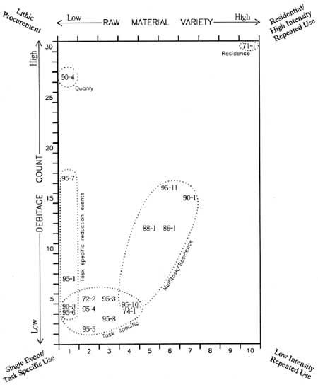
Table 4.6 shows the frequency of raw materials presently identified in the Park. Debitage to material and material to debitage ratios are included, though the authors found that with Mount Rainier's small samples, simple count comparisons illustrated variation between sites more dramatically. Note that only data from the 1995 reconnaissance are included in the table with the exception of site FS 90-04 (Tum Tum Quarry). This site is included to illustrate the extreme debitage to material type ratio characteristic of a known lithic procurement site. Figure 4.3 graphically displays site debitage count to raw material variety, showing clear cluster patterns in the analyzed Mount Rainier sample.
Table 4.6 Debitage Raw Material Variability at Mount Rainier
| Site No. | Debitage (D) Total | Raw Material (M) Type Count |
D:M Ratio | M:D Ratio |
|---|---|---|---|---|
| FS 90-03 | 4 | 1 | 4.0 | 0.25 |
| FS 95-06 | 4 | 1 | 4.0 | 0.25 |
| FS 95-01 | 7 | 1 | 7.0 | 0.1 |
| FS 95-07 | 17 | 1 | 17.0 | 0.06 |
| FS 90-04 | 27 | 1 | 27.0 | 0.04 |
| FS 95-05 | 2 | 2 | 1.0 | 1.0 |
| FS 95-04 | 4 | 2 | 2.0 | 0.5 |
| FS 72-02 | 5 | 2 | 2.5 | 0.4 |
| FS 95-08 | 3 | 3 | 1.0 | 1.0 |
| FS 95-03 | 5 | 3 | 1.7 | 0.6 |
| FS 74-01 | 4 | 4 | 1.0 | 1.0 |
| FS 95-10 | 4 | 4 | 1.0 | 1.0 |
| FS 88-01 | 12 | 4 | 3.0 | 0.3 |
| FS 86-01 | 12 | 5 | 2.4 | 0.4 |
| FS 95-11 | 16 | 5 | 3.2 | 0.3 |
| FS 90-01 | 15 | 6 | 2.5 | 0.4 |
| FS 71-01 | 30 | 10 | 3.0 | 0.3 |
|
| Figure 4.3 Plot of Debitage Counts by Material Variety (1995 Reconnaissance Data) |
Four, perhaps five patterns are apparent in the debitage count/variety plot above. The known quarry site on the flank of Tum Tum Peak in the Park's southwest quadrant (FS 90-04) stands out clearly in the upper left lithic procurement corner of the graph. In the far left lower portion of the graph are sites characterized by the reduction of a single raw material type. This assemblage attribute, combined with low artifact counts and low technological diversity (not a plotted variable) suggests that these sites reflect single reduction events. In comparing sites, however, raw material types vary, as does the reduction stage and/or trajectory represented. Indeed, the four plotted single reduction event sites all appear to be somewhat different. They include: a) expedient core reduction of local chert on the east flank of Mother Mountain (FS 95-06); b) prepared core reduction of local metasediment at Tipsoo Lake (FS 95-01); c) mid through late stage biface manufacture of local jasper at Windy Gap (FS 95-07); and d) tool finishing or rejuvenation of probably exotic chert from an imported tool also located at Windy Gap.
Based on assemblage characteristics alone, it appears that the single reduction event sites cannot be placed unambiguously into a single functional category. As a group, they are technologically diverse and appear to crosscut a variety of environmental contexts. It also is important to recognize that these debitage assemblages may be directly related to an on-site processing task (e.g., expedient tool manufacture) or, alternatively, stone reduction during down-time and therefore secondary to the primary site function. Regardless of apparent inferential ambiguity, it is clear that the relatively small, technologically restricted site assemblages represent very short-term, low-intensity uses of the site locality. The fact that raw material from most of these sites (3 of 4) are from locally derived materials is probably the result of minimizing weight by incorporating locally derived materials into a functional, transportable (or disposable) tool kit. Thus, while not lithic procurement sites per se, the single reduction event sites are likely to occur close to the source locality and incorporate some of the reduction stages common to procurement localities.
With the possible exception of the two single source sites noted above and site FS 95-10 at Forgotten Creek in the southwest quadrant, sites clustered at the lower left of the plot (low count/low variety) all display characteristics consistent with low intensity, task specific use. In addition to increased material variety, debitage tends toward later stage reduction and repair expected at a hunting rather than a manufacturing stop. Exceptions include Mt. Pleasant (FS 72-02) and Vernal Park (FS 74-01) rockshelters, both of which have early stage, core reduction as well as secondary and tertiary stages represented. As mentioned above, core reduction may have occurred during down time. Thus, core reduction is expected in these small, high elevation rockshelters use of which may have involved forced down-time as hunters waited for storms to lift. The Forgotten Creek Site (FS 95-10), an upper forest level surface site in the Park's NW quadrant also fits these general parameters. However, presence of a basalt grinding stone at this site coupled with its forest/subalpine ecotonal setting suggest a broader range of activities and perhaps residence.
Several sites provide evidence of multiple task use and/or mixed group residence. These include site FS 95-10 noted above: the central cluster of fours sites in Figure 4.3–an extensive site at Tipsoo Lake (FS 88-01), Frozen Lake (FS 86-01), Sunrise Ridge Borrow Pit Site (FS 90-01), and a site on the northern flank of that ridge (Sunrise Lake Site, FS 95-11)–and the lone high density/high variety site at Buck Lake (FS 71-01) in the Park's extreme NE quadrant. The Frozen Lake Site appears to be a primary reduction and butchering location as noted above. Its exposed alpine setting makes all but very short term residence improbable. The remaining sites are situated in more protected upper forest/lower subalpine ecotonal settings. The mix of materials, artifacts and setting is consistent with the residential inference.
In sum, the variety of artifacts, technological attributes and material classes presently documented at Mount Rainier National Park suggests a limited variety of basic land-use functions. These include (but are not limited to) lithic procurement, early stage lithic reduction and manufacturing, limited-task hunting and hunting/butchering localities, multi-task localities with vegetal processing, and probable mixed group residence. Ecological as well as material contrasts appears to exist between multi-task/residential sites biased toward the upper forest/lower subalpine ecotone, versus limited task sites in subalpine and alpine settings. We urge that more refined test and analytical procedures be directed to a subset of the multi-task/residential sites and to the task-specific localities to better establish functional patterns among Mount Rainier prehistoric site localities. Until such time, patterns discussed here provide a preliminary means to characterize the Mount Rainier prehistoric archaeological record on functional grounds.
Radiocarbon, Stratigraphy, Projectile Points
and Temporal Range at Mount Rainier
Functional classes suggested in the sections above and below do not discriminate potential changing use through time, nor do they inform us at all as to the potential temporal depth for human use of the mountain. In Chapter 2, ecological arguments were developed suggesting that human use of Mount Rainier landscapes could have begun as early as about 8,500 years ago and continued throughout the prehistoric period. Unfortunately, Mount Rainier chronometric data unambiguously linked to cultural remains are limited. The only radiocarbon dates currently considered culturally meaningful are two dates from Berkeley Rockshelter (FS 86-02)–1970 ± 80 years: 20 B.C. (Beta 44528) and 1070 ± 90 years: A.D. 880 (WSU 3666). [29] Additional temporal indicators must rely on less precise stratigraphic position and projectile point stylistic attributes. While these data are not sufficient to meaningfully address possible forager to collector land-use changes through time, they nonetheless suggest a long period of use of Mount Rainier landscapes.
Stratigraphic position of chipped stone debitage between Mount Rainier C and Mt. St. Helens Yn tephra at the Sunrise Ridge Borrow Pit Site (FS 90-01) push the temporal range back to circa 3,750 to 2,300 years for use of that site. Because of the distinct stratigraphic signature left by Mount Rainier's repeated volcanism, it is likely that additional testing at identified sites will expand our stratigraphic/temporal database. At present however, FS 90-01 and FS 86-02 remain our only firmly (if incompletely) dated sites in the Park.
Variation in artifact type, particularly in hafting width, suggests a still longer temporal range for Mount Rainier's prehistoric record. A general, though imperfect, time-related shift from lance to dart to arrow-sized projectile points is now well recognized across North America. At a broad level, large-sized piercing (or multi-task piercing-cutting) points dominated North American hunter-gatherer durable tool kits from earliest entry to about 6,500 to 5,000 years ago. Clovis and Folsom styles– named after type sites in New Mexico but widely distributed across the west–are among the best known of these early tool types. Perhaps responding to the need to exploit medium to large sized fauna at greater distance, the arm extending throwing stick (atl atl) became a common hunting tool during the mid-Holocene. Projectile points attached to dart foreshafts thrown by these implements were smaller than early Holocene lance points, but still large enough to fill multiple piercing and cutting functions. Windust and the locally common, willow leaf shaped Cascade point are examples of dart points typically assigned a mid-Holocene date. Plausibly responding to increasing pressure to exploit still smaller, faster moving game, bow and arrow technology became common between about 2,000 and 1,500 years ago (though the atl atl and dart-sized projectile points continued to be used locally). While morphologically varied, arrow points typically are small and intended solely for piercing.
Because they were designed to be mounted on progressively smaller shafts, lance, dart and arrow points can be discriminated objectively (if approximately) by the hafting width of the base (see Corliss 1972; Thomas 1978). Here, hafting width of greater than 16 mm is assumed to be associated with lance technology. A large assemblage dominated by such large points would be of early Holocene origin; certainly dating earlier than 5,000 years ago. A limited assemblage or, more commonly, an isolate can be very tentatively assigned to this same period. Points are considered to be dart-sized in the haft width range of 7 to 16 mm. An assemblage dominated by dart-sized points typically is assigned a mid-Holocene age range, circa 5,000 to 2,000 years ago. Because darts continued to be used into the late Holocene in the Cascades (cf., Burtchard 1990:147), isolates, particularly Cascade style isolates, should be evaluated with caution. Arrows are assumed to have a haft width of less than 7 mm and are assumed to appear after 2,000 years ago. Accordingly, presence of arrow-sized points, in an assemblage or as an isolate, provides inferential grounds for late Holocene use. [30]
Table 4.7 contains the results of a basic analysis of projectile points observed in the field or curated at Park headquarters in Longmire. Period and age ranges are based on the assumptions outlined above, and should be considered tentative in the absence of larger sample sizes. Such limitations notwithstanding, it should be noted that the wide range of types and haft widths are consistent with a long temporal range for human use of Mount Rainier. These data suggest use from early to late Holocene. Firmer clarification of the extent of that use awaits further archeological research.
Table 4.7 Mount Rainier Projectile Point Types and Inferred Age
| Site/Cat. No. | Hafting Element | Style | Haft Width | Technology | Period | Inferred Age |
|---|---|---|---|---|---|---|
| FS 90-02 | barbed expanding stem | 5 mma | Arrow | Late Holocene (Late Archaic) | < 2000 B.P. | |
| Cat. 131 | barbed expanding stem | 7 mm | Arrow | Late Holocene | < 2000 B.P. | |
| IF 01-68 | barbed straight stem | 6 mm | Arrow | Late Holocene | < 2000 B.P. | |
| IF 01-84 | shouldered contracting stem | < 5 mm | Arrow | Late Holocene | < 2000 B.P. | |
| Cat. 133 | barbed contracting stem | Pin Stem | 5 mm | Arrow | Late Holocene | < 2000 B.P. |
| FS 86-02b Cat. 20, 21, 28, 29 | four triangular (#20 with concave base) | < 7 mm | Arrow | Late Holocene | < 2000 B.P. | |
| Cat. 3, 11, 36 | three side notch | < 7 mm | Arrow | Late Holocene | < 2000 B.P. | |
| Cat. 10 | expanding stem corner notch | < 7 mm | Arrow | Late Holocene | < 2000 B.P. | |
| Cat. 2 | Unknown | < 7 mm | Arrow | Late Holocene | <2000 B.P. | |
| IF 01-70 (a) | barbed indeterm stem | < 5 mm | Arrow | Late Holocene | < 2000 B.P. | |
| (b) | triangular | 22.5 mm | Lance | Early Holocene (Early Archaic) | > 5000 B.P. | |
| FS 71-01 | basal notch | 10 mm | Dart | Mid-Holocene (Mid Archaic) | 5000 - 2000 B.P. | |
| FS 90-03 | indeterminent | 13 mm | Dart | Mid Holocene | 5000 - 2000 B.P. | |
| Cat. 132 | shouldered contracting stem | 13 mm | Dart | Mid Holocene | 5000 - 2000 B.P. | |
| FS 86-01 (a) | barbed contracting stem | 10 mma | Dart | Mid Holocene | 5000 - 2000 B.P. | |
| (b) | indeterminent expanding stem | 19 mma | Lance | Early Holocene (Early Archaic) | > 5000 B.P. | |
| (c) | side notch | Northern Side Notch | 16 mm | Lance | Early Holocene | > 5000 B.P. |
| FS 95-10 | ovate | Cascade | 12 mm | Dart | Early Holocene | > 5000 B.P. |
| IF 02-63 | ovate | Cascade | unknown | Dart/Lance | Early Holocene | > 5000 B.P. |
Table Notes:
aMeasurement from an artifact sketch.
bSee descriptions and measurements in Bergland (1988:50) for
a slightly different breakdown.
Artifact Variability, and Site and Isolate Groups on Mount
Rainier
In Figure 4.3 and associated text, Mount Rainier sites were grouped in a very preliminary fashion into four or five site groups based on a ratio of lithic debitage count and raw material variety (with interpretive complexity added by context and general assemblage considerations). Here, sites and isolated finds are grouped by reference to their broader assemblage composition irrespective of material type. As before, our intent is to provide a descriptive partition of Mount Rainier prehistoric remains that carries implications for site function. Multiple artifact site groups are considered first and isolates second. A summary consideration based on combined criteria concludes the section.
Assemblage-based Site Groups
Sites containing multiple artifacts are grouped by assemblage structure as an index of site types in Table 4.8 below. The table groups sites into three major categories based solely on surface evident remains. Group 1 is defined by the presence of a broad lithic assemblage; including debitage, heavy tools (hammer stones, grinding stones and other large, course grained lithic tools) and/or fire cracked rock. Lightweight tools (cores, bifaces, flake tools and projectile points) may or may not be present. Group 2 includes sites with only debitage and lightweight lithic tools. Group 3 includes sites with debitage only (a quartzite manuport and bird gastroliths are not counted as tools for purposes here). In essence, this grouping includes sites most likely to be associated with longer term, multi-task use (Group 1), a variety of more limited and/or shorter term mixed task uses (Group 2), and a set of sites more likely to have been task-specific or very short-term use localities (Group 3).
Table 4.8 Sites Grouped by Lithic Assemblage Similarities as an Index of Site Types.
| Group | Site No. | Debitage | Light Tools | Heavy Tools |
Tool to Debitage Ratio | Fire Cracked Rock | Other | Total |
|---|---|---|---|---|---|---|---|---|
| 1 | FS 90-01 FS 95-11 FS 95-10 |
15 16 4 |
1 1 |
4 2 1 |
.33 .13 .50 |
2 5 4 | 22 23 10 | |
| 2a | FS 86-01 FS 90-02 |
13 3 |
10 4 | .77 1.33 | 23 7 | |||
| 2b | FS 88-01 FS 72-02 FS 86-02 (test sample)a FS 90-03 FS 95-06 FS 95-08 |
12 11 5 (327) 4 4 3 |
2 2 2 (37) 1 1 1 | (1) |
.17 .18 .40 (.12) .25 .25 .33 | 14 13 7 (365) 5 5 4 | ||
| 2c | FS 71-01 FS 95-07 |
33 17 |
3 1 | .09 .06 | 36 18 | |||
| 3a | FS 90-04 | 27 | .00 | 27 | ||||
| 3b | FS 95-01 FS 95-04 FS 74-01 FS 95-03 FS 95-05 |
7 4 4 5 2 | .00 .00 .00 .00 .00 | 1b 2c |
7 4 4 6 4 |
Table Notes:
a(test sample) results are from Bergland's (1988) work at Berkeley Rockshelter
bsmall quartzite cobble manuport
cbird gastroliths (gizzard stones)
Light tools: fine-grained lithic tools including cores, flake tools, bifaces, and projectile points.
Heavy tools: course grained lithic tools, primarily ground stone.
As noted above, Group 1 sites have assemblages that include debitage, heavy tools (particularly ground stone) and/or fire cracked rock indicating cooking activities. We expect lightweight tools to be present as well, though in one case none were found. The artifact assemblage is diverse with evidence that plant food processing is part of a broader range of activities. Combined presence of such remains is consistent with a mixed sex and age, multi-task residential camps. Furthermore, the three Group 1 sites– FS 90-01 (Sunrise Ridge Borrow Pit), FS 95-11 (Little Sunrise Lake) and FS 95-10 (Forgotten Creek) all occupy the upper forest to lower subalpine setting expected to be associated with such use. Interestingly, two of the sites–FS 90-01 and FS 95-11–also appear in the central (multi-task/residential) cluster generated by lithic raw material/debitage count results displayed earlier in Figure 4.3.
Group 2 sites (surface evident lithic debitage and light tools only) can be divided into three subgroups by markedly different tool to debitage ratios. Group 2a sites–FS 86-01 (Frozen Lake) and FS 90-02 (Sarvant Glaciers)–have a very high fraction of formed tools and cores to debitage (above 75%). Indeed in the latter case, tools actually exceed the debitage count. We believe that the high fraction of formed bifaces at these locations is consistent with use for short-term hunting and butchering activities. Both sites are situated in exposed alpine tundra settings, reducing the probability of sustained residence. Combined environmental context and assemblage characteristics suggest mountain goat processing. Because of its high material variety, FS 86-01 grouped with the central moderate intensity/residential cluster in Figure 4.3. It is more likely, however that the relatively large assemblage and material variety is a product of repeated short-term use. Unfortunately, the Sarvant Glaciers site remained under snowpack in 1995 and could not be reevaluated in the field (and hence was not included in Figure 4.3).
Group 2b includes a variety of sites with a tool to debitage ratio falling above 10% and below 50%. As with other Group 2 sites, absence of ground stone and fire cracked rock suggests very shortterm use by a segment of a broader social group. The moderate tool to debitage ratio and absence of heavy tools is expected at base camp sites in which people finished and maintained tools, and perhaps conducted limited processing tasks. Such sites may be short-term locations such as resting stops.
Two rockshelters fall within Group 2b–FS 72-02 (Mt. Pleasant) and FS 86-02 (Berkeley Rockshelter). In the latter case, it is interesting to note similarity between surface and test excavated remains. Despite the larger test sample, the only "heavy tool" was an single stone abrader/shaft smoother, suggesting hunting tool maintenance anticipated for such sites. Small surface sites at Windy Gap (FS 90-03), Mother Mountain (FS 95-06) and Middle Spunkwush Lake near Windy Gap (FS 95-08) are all in similar subalpine context and could plausibly have supported short-term hunting camp functions. The larger site at Tipsoo Lake (FS 88-01) is the most problematic of the group. Its higher raw material variety grouped it with the more residential/intensive /repeated use group in Figure 4.3. Ongoing test excavations at the site (Sullivan pers. com. 1996) indicate that a higher fraction of heavy tools may be present in subsurface context, suggesting that the site is better placed with the multi-task, residential group.
Group 2c sites are distinguished from those above by very low tool to debitage ratios (below 10%). Though lumped together by the assemblage criteria applied here, the sites differ substantially in site context, material variety and probable function. Despite its lack of surface evident heavy tools, site FS 71-01 at Buck Lake has both the highest surface count and greatest raw material variety of any site currently documented in the Park. This site's dispersed scatter above and around the northeastern margin of the lake suggests repeated use unmatched by other sites in the sample. Further testing is recommended to determine the extent to which the surface pattern holds (suggesting repeated shortterm hunting camp use) or adds a greater array of heavy tools to the assemblage (suggesting multi-task, mixed residential use). Because the subalpine setting near the forest margin, and material density and variety, more closely matches Group 1 residential sites than other Group 2 sites, we consider it likely that Buck Lake ultimately will be shown to be a repeated use residential site. Current data, however, suggest repeated, shorter-term, task-specific use.
Site FS 95-07, a single material site at Windy Gap, qualifies as a Group 2 site solely on the presence of a single use flake scraper. As with nearby Windy Gap Site FS 90-03, task-specific camp function is probable, though the dominant activity here (at least as indicated by the lithic remains) appears to have been a single lithic reduction event using material collected at a primary source located somewhere in the vicinity.
Group 3 sites are those that contain only debitage, or debitage with a small apparently unused quartzite cobble (FS 95-03), or bird gastroliths (FS 95-05). The single Group 3a site is the chert quarry on Tum Tum Peak (FS 90-04), which accounts for its high debitage count of single source material (see Figure 4.3). Remaining Group 3b sites vary in the specific character of the debitage assemblage, suggesting functional, cultural, or environmental contextual differences (limiting the utility of group classification). Vernal Park Rockshelter (FS 74-01) almost certainly served short-term camp functions similar to other rockshelters included in Group 2b. The site has been used repeatedly as an historic period camping place, and it is likely that surface evident formed tools simply have been collected and removed. Single source assemblage characteristics of the small Tipsoo Two Site (FS 95-01) suggest a single event, perhaps related to more general use of the lakeside environment evident at the larger, more complex Tipsoo One Site (FS 88-01). Two adjacent small sites on Sunrise Ridge (FS 95-03 and FS 95-04) and site FS 95-05 on the upper cirque rim overlooking Mist Park appear to be single event stops or very limited use areas. Again, such inferences must be considered suspect in the absence of more robust test data.
The three to six-part site grouping suggested here is based on sites documented during the present reconnaissance effort. We emphasize again, however, the limitations of the database upon which the classification scheme relies. Small sample size and data skewing from surface observation in a forested, volcanically active depositional environment undoubtedly color what otherwise seem to be quantitatively sound arguments. As more sites are found and more test data become available, the groupings will need to be changed to fit increasing site diversity. Nevertheless, the site categories defined below provide preliminary organization of Mount Rainier sites on the basis of observed assemblage structure.
Mount Rainier Isolated Find Groups
By definition, isolate assemblages (1 to 2 artifacts) are not amenable to refined quantitative taxonomy. Generally, we expect isolates to represent specific, non-repeated short-term events or tasks–most often spent shots, or lost or broken and exhausted tools. Table 4.9 lists currently documented isolates in Mount Rainier National Park. Be aware, however, that several, perhaps many, of these isolates may be more than they appear. Because Mount Rainier contains Holocene paleosols buried under varying depths of volcanic tephra, it is likely that some localities that appear to be isolates are surface manifestations of substantially larger, more complex buried sites. Both site and isolate locations are shown on Figure 4.2, and on the color quadrant maps in Chapter 2.
Table 4.9 Isolated Finds Grouped by Similarity of Lithic Remains
| Group | Isolate No. | Debitage | Core | Biface | Projectile Point | Flake Tool | Manuport | Total |
|---|---|---|---|---|---|---|---|---|
| A | IF 01-70 IF 02-63 IF 01-84 |
2 1 1 | 2 1 1 | |||||
| B | IF 01-87 IF 05-95 |
1 1 | 1 | 1 2 | ||||
| C | IF 01-72 IF 01-68 IF 03-95 IF 06-95 |
1 1 1 1 | 1 | 1 | 1 | 1 | 2 2 2 2 | |
| D | IF 11-95 IF 07-95 IF 02-95 IF 04-95 IF 01-77 IF 01-95 |
1 1 1 1 1 1 | 1 1 1 1 1 1 | |||||
| E | IF 08-95 IF 09-95 IF 10-95 |
1 1 2 | 1 1 2 |
Table 4.9 is intended more as a descriptive listing of isolated remains than an attempt to arrive at functional divisions. Even so, a few comments are in order about the contents of each category. Group A isolates are solely projectile points. Such finds are among the most likely tools to be lost during a hunting event. Accordingly, Group A are among the most likely artifacts to represent truly isolated, idiosyncratic use of the landscape. Group B isolates are non-projectile point tools. They may represent truly lost tools or a very limited (or buried) specific task locality such as an expedient butchering site. Group C includes isolates with both debitage and tools. Because more than one item is involved, the probability is increased that the finds represent specific task localities in which tools were maintained, or a flake tool made and used (as opposed to simple tool loss). Group D isolates are debitage only. If flake tools were present, they have been collected and removed or buried. Like Group C, debitage is not likely to reflect simple loss. Accordingly, despite their unassuming character, Groups C and D, and perhaps Group B isolates should be considered likely candidates for site classification when subsurface test procedures become possible. Group E isolates are manuports. Manuport functions are unknown, but could plausibly represent raw material transport. Since they cannot be linked directly to predominantly prehistoric technology, isolated manuports cannot be linked unambiguously to prehistoric use. However, manuports included in Table 4.9 are not associated with historic period rubbish and, therefore, are considered most probably prehistoric in origin.
In sum, lithic analyses pursued here have been devoted to developing interpretive discussion of different aspects of lithic assemblages that make up Mount Rainier's prehistoric archaeological record. The foregoing series of tables and accompanying text are intended to provide: 1) a descriptive summary of the currently analyzed lithic sample; and 2) preliminary temporal and functional interpretations based on available assemblage characteristics. These data, while limited, suggest that: a) Mount Rainier landscapes have been used for a period of time exceeding 5,000 years in the prehistoric past; b) such use continued throughout the Holocene; and c) quantitatively discernable, functionally relevant variation exists among sampled sites and isolates in the Park. In Chapter 5, combined assemblage and environmental data are used to develop a working model of Mount Rainier site types and distribution. The section below concludes this chapter's review of reconnaissance results by evaluating the relationship between Mount Rainier's current archaeological database and a set of environmental variables commonly assumed to be linked to presence of prehistoric remains.
ENVIRONMENTAL CHARACTERISTICS AND PREHISTORIC SITE DENSITY
Use of an environmentally grounded approach toward understanding the archaeological record of the Pacific Northwest is not particularly new. Environmentally based predictions have been employed by federal agencies for some time to attempt to determine the location of prehistoric remains in advance of field inventory. Though causal connections are seldom specified, attributes such as elevation, slope, solar exposure, landform type and (especially) distance to water have been assumed to have conditioned human use of the mountains in the past and, hence, considered to be critically associated with the location of archaeological remains in the present (see Kvamme 1988:331-338). These predictions are then used to develop probability zones that serve to simplify survey obligations by directing inventory coverage differentially toward the higher probability landforms predicted by the model.
Elsewhere, I have been critical of these approaches largely because they tend to lack consideration of underlying causes for the patterns they purport to predict and are self-fulfilling in application, thereby hindering empirical falsification of the models' predictions (see Burtchard and Keeler 1991:107-122). In the Burtchard and Keeler study, Mt. Hood National Forest's predictive model (emphasizing distance to water, landform, and slope) was evaluated in light of the Forest's growing site database. While a strong association was found between the relative density of prehistoric remains to elevation and slope, only weak association was found with distance to water, and none with solar exposure. A tendency for site association with montane basins, ridges and saddles, sideslope benches, and valley floodplain terraces is largely subsumed by elevation and slope (Burtchard and Keeler 1991:115-117). Working with these results, Mt. Hood National Forest restructured site inventory procedures to accommodate critical resource distribution patterns related to a less restrictive range of environmental variables.
The questionable utility of non-causal models notwithstanding, it is not unreasonable to expect prehistoric populations to have selected campsites with an eye toward water availability, flat ground, solar gain and so on–particularly when such characteristics occur in association with economically productive habitats. This section examines the association between the current Mount Rainier site and isolated find database with a set of particular environmental characteristics commonly used in the aforementioned survey systems. Table 4.10 summarizes these basic categories for Mount Rainier National Park. Figures and associated discussion that follow illustrate the results. Patterned association between environment/resource zone is presented first to demonstrate the strong relationship emphasized throughout this report. As will be seen, available data also suggest a strong association with elevation (which, of course, is linked to differential use of subalpine and alpine zones) and with relatively flat ground. As in the Mt. Hood study, patterned association with distance to water, landform type and solar exposure is more equivocal, though the present small sample size may color the result. Please note that in order to maximize sample size, no effort has been made to distinguish between site types as has been done above and as modeled formally in Chapter 5. Prehistoric sites and isolates for which sufficient data are available are considered equally.
Table 4.10 Mount Rainier Site/Environmental Associations
| Field Number |
Environmental Zone |
Elevation (ft) |
Solar Exposure |
Degrees Slope |
Landform | Meters to Water |
|---|---|---|---|---|---|---|
| FS 90-04 | Forest | 4080 | S | 20 | Mtn. Ridge Top | 2500 |
| FS 95-10 | Forest | 4220 | E | 4 | Mtn. Basin Floor | 20 |
| IF 02-63 | Subalpine/Burn | 4550 | NE | 3 | Mtn. Basin Floor | 100 |
| IF 01-68 | Forest | 4760 | SW | 1 | Mtn. Bench Top | 40 |
| FS 90-01 | Forest | 4900 | S | 2 | Mtn. Bench Top | 200 |
| FS 95-02 | Subalpine | 5130 | NE | 8 | Mtn. Basin Edge | 20 |
| IF 01-95 | Subalpine | 5240 | SW | 3 | Mtn. Basin Floor | 15 |
| FS 88-01 | Subalpine | 5320 | SE | 2 | Mtn. Basin Floor | 10 |
| FS 95-01 | Subalpine | 5330 | E | 1 | Mtn. Bench Top | 20 |
| FS 95-11 | Subalpine | 5380 | SE | 12 | Mtn. Ridge Slope | 5 |
| FS 63-01 | Forest | 5400 | N | 30 | Mtn. Valley Cliff Base | 60 |
| IF 01-72 | Subalpine | 5480 | W | 4 | Mtn. Basin Floor | 10 |
| FS 95-06 | Subalpine | 5540 | SE | 5 | Mtn. Bench Edge | 12 |
| FS 95-11 | Subalpine | 5540 | W | 1 | Mtn. Basin Floor | 45 |
| FS 71-01 | Subalpine | 5580 | SW | 2 | Mtn. Bench Top | 30 |
| IF 04-95 | Subalpine | 5600 | SW | 5 | Mtn. Tableland Top | 10 |
| IF 03-95 | Subalpine | 5640 | SW | 3 | Mtn. Tableland Top | 10 |
| FS 86-02 | Subalpine | 5640 | SE | 30 | Mtn. Valley Talus Base | 125 |
| FS 90-03 | Subalpine | 5690 | E | 2 | Mtn. Ridge Saddle | 8 |
| FS 95-08 | Subalpine | 5720 | SE | 4 | Mtn. Basin Edge | 40 |
| IF 01-77 | Subalpine | 5720 | W | 2 | Mtn. Ridge Saddle | 50 |
| FS 74-01 | Subalpine | 5780 | SE | 1 | Mtn. Talus Base | 10 |
| FS 95-07 | Subalpine | 5870 | SE | 1 | Mtn. Ridge Saddle | 200 |
| FS 72-02 | Subalpine | 5880 | E | 37 | Mtn. Cliff Base | 200 |
| IF 01-84 | Subalpine | 5900 | E | 2 | Mtn. Basin Floor | 50 |
| IF 08-95 | Subalpine | 5980 | SE | 2 | Mtn. Bench Top | 75 |
| IF 09-95 | Subalpine | 6060 | E | 3 | Mtn. Bench Top | 150 |
| FS 95-05 | Subalpine | 6120 | NE | 4 | Mtn. Ridge Edge | 50 |
| IF 10-95 | Subalpine | 6170 | SW | 10 | Mtn. Bench Top | 500 |
| FS 95-03 | Subalpine | 6240 | SW | 1 | Mtn. Bench Top | 85 |
| IF 06-95 | Subalpine | 6240 | SW | 1 | Mtn. Bench Top | 15 |
| IF 07-95 | Subalpine | 6260 | SW | 1 | Mtn. Ridge Top | 25 |
| FS 95-04 | Subalpine | 6290 | E | 2 | Mtn. Ridge Crest | 60 |
| IF 05-95 | Subalpine | 6340 | N | 1 | Mtn. Bench Top | 20 |
| FS 90-02 | Alpine | 6650 | S | 2 | Mtn. Ridge Saddle | 250 |
| IF 01-87 | Alpine | 6700 | W | unknown | Mtn. Ridge Crest | unknown |
| FS 86-01 | Alpine | 6720 | E | 4 | Mtn. Ridge Saddle | 50 |
| IF 01-70 | Alpine | 7500 | SW | unknown | Mtn. Ridge | unknown |
Environmental/Resource Zones and Elevation
Throughout this report, it has been argued that high resource productivity of Mount Rainier's subalpine and alpine habitats should have served to focus human activity on these habitats during the prehistoric past. If so, these zones will display high site density relative to other montane habitats. The prediction is deductive in that it flows directly from environmental considerations rather than the archaeological record itself. Archaeological data provides means to test, rather than to generate expectations. While the quality of the test will improve as additional surveys are completed, available site data from Mount Rainier clearly are consistent with the predicted subalpine/alpine pattern.
Table 4.11 displays site count by the five major resource zones employed to characterize the Park–high energy floodplains, maritime forest, subalpine parkland, alpine tundra, and perpetual snowfields and associated glacial rubble. Area for each of these zones is computed from GIS data used to generate color fold-out Figures 2.10 through 2.13 in Chapter 2. Both site count and site density figures show the clear subalpine pattern. Even if site count for maritime forest were tripled to accommodate poorer surface exposure and lower survey fraction, site density results would remain below alpine and well-below subalpine zones. In my opinion, the pattern is far too strong to be product of either chance or site discovery biases.
Table 4.11 Mount Rainier Site Count and Density, by Environmental Zone
| Environmental Zone | Total Area | Site Count | Site Density (sites/hectare) | |
|---|---|---|---|---|
| Acres | Hectares | |||
| Floodplain | 7,882 | 3,190 | 0 | 0.0000 |
| Forest | 123,557 | 50,002 | 5 | 0.0001 |
| Subalpine | 53,898 | 21,812 | 29 | 0.0013 |
| Alpine | 25,404 | 10,281 | 4 | 0.0004 |
| Glacial | 24,871 | 10,065 | 0 | 0.0000 |
Figure 4.4 shows the environmental zone and site frequency relationship graphically. The graph is conservative in that percentages are computed on the basis of simple site count per zone. Had it been normalized to display site density per hectare as shown in the final column of Table 4.11, the contrast between subalpine and forest zones would have been even more pronounced; the contrast between subalpine and alpine zones, somewhat less so.
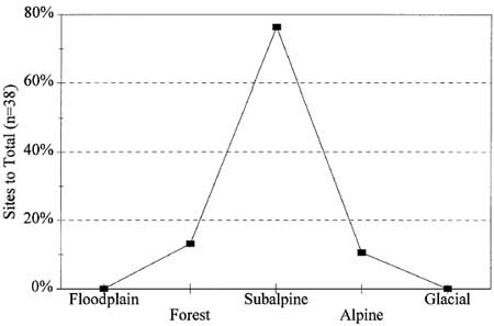
|
| Figure 4.4 Site Relative Frequency, by Environmental Zone |
Figure 4.5 shows the relationship between prehistoric site frequency and elevation. The similarity between this graph and Figure 4.4, of course, is due to the direct link between elevation shown here and environmental zones shown above. In concert, the figures reinforce the critical role played by upper elevation landscapes in prehistoric land-use practices and, hence, on the archaeological record of that use. Twenty-nine sites and isolates (76% of the sample) are situated in subalpine contexts. Adding sites in alpine settings increases the fraction to 87%. Furthermore, all of the maritime forest sites are located in upper elevation forest contexts between 4,000 and 5,000 ft or higher–locations that arguably provide ready access to subalpine environments and/or were used at times when the closed forest fringe was lower. In short, the upper elevation pattern is clear and robust, and, in light of the manner in which these habitats would have conditioned resource availability throughout the past, should not be surprising.
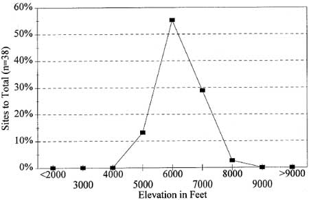
|
| Figure 4.5 Site Relative Frequency, by Elevation Slope |
Figure 4.6 shows the relationship between slope and site frequency in the Mount Rainier sample. Seventy-five percent of the documented sites are found on landforms with a local slope of 5o (8.8%) or less. Assuming that most lithic aggregations represented in the sample are associated with at least short term residence, the tendency toward selection of flat ground is understandable–flat ground simply is best suited to sleep and for conducting a variety of maintenance tasks. Slope is irrelevant, of course, for sites such as quarries (e.g., FS 90-04) and lost implement localities (e.g., IF 10-95), as well as for sites in disturbed, secondary context such as IF 11-95. Cliff and talus rockshelters such as FS 63-01, FS 86-02 and FS 72-02, while often occurring on steep slopes, have interior use spaces which are quite flat. Accordingly, the tendency for sites to be located on low gradient terrain, or to avail themselves of small flat-ground irregularities on otherwise sloping ground, is strong in the Mount Rainier sample (as elsewhere) and may be explained by the tendency to select such ground for a variety of task-specific and residential purposes.
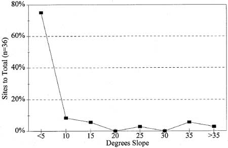
|
| Figure 4.6 Site Relative Frequency, by Slope |
Distance to Water
In a similar evaluation of site distribution in the vicinity of Mt. Hood, we found a relatively weak association between lithic scatters and distance to water–47% within 50 m, 59% within 100 m (Burtchard and Keeler 1991:117-119). The water association in the Mount Rainier sample is somewhat stronger– 53% within 50 m, 75% within 100 m (see Figure 4.7). It is not clear, however, if the difference is simply due to small sample size for Mount Rainier or if the distinction is genuine. In dry environments, water can be a significant determinant of human movement and settlement patterns. Water is, after all, heavy, difficult to contain and required daily. In wetter environments such as the western and high Cascades, water imposes less of a constraint on human land-use options simply by virtue of its widespread availability. Because Mount Rainier offers a variety of water sources, the relationship between site location and access to water should be weak. Since water is important, it makes sense to settle near a source when it is handy to do so. In a place with many alternative sources such as Mount Rainier, however, it is equally likely that sites will be located well away from visible sources of supply. In the event the Park implements some form of predictive survey strategy, it is suggested that distance to water not be considered a key variable in structuring the survey design.
Solar Exposure
While solar exposure seldom appears in predictive site location models, it is not unreasonable to expect people to select sites with good solar exposure in cold environmental circumstances. Since Mount Rainier was almost certainly used during summer months, however, we would expect a tendency to maximize solar gain to be offset by countervailing considerations such as visual exposure, wind direction, natural rockshelter orientation and so on. Accordingly, we would expect to see little relationship between site location and solar orientation. Histogram Figure 4.8 suggests that this is so.
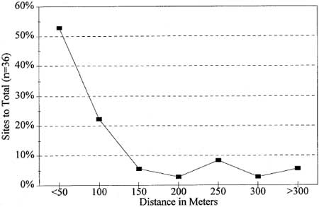
|
| Figure 4.7 Site Relative Frequency, by Distance to Water |
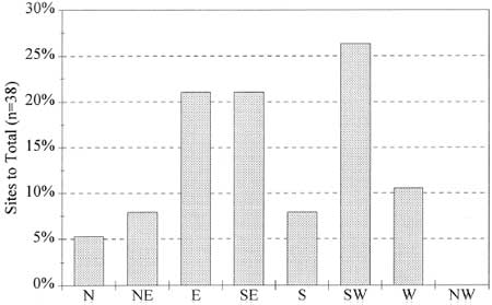
|
| Figure 4.8 Site Relative Frequency, by Solar Orientation |
Landform
A glance at the variety of landscapes represented in site/isolate summary Table 4.10 shows that Mount Rainier's prehistoric sites are found in a variety of upland settings. Other than re-emphasizing the tendency toward subalpine/flat ground site selection, little clear patterning is evident in the available data. Commonly represented in the sample are side slope bench settings, ridge crests and saddle passes between drainages, cirque basins, and, of course, cliff face and talus rubble rockshelters. Figure 4.9 below summarizes the landform variety characteristic of the Mount Rainier sample. As with solar exposure and distance to water, specific landform characteristics do not appear to be significantly associated with the location of prehistoric archeological remains.
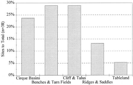
|
| Figure 4.9 Site Relative Frequency, by Landform Group |
The most salient pattern that has been emphasized in this chapter is the clear site bias toward subalpine to alpine habitats as predicted by theoretically derived expectations and as observed during the early historic period. Basic prehistoric site and isolate data (as well as that for two historic period sites) have been provided in tabular form and plotted onto a general location map. Professional readers may wish to refer to individual site forms in the project's companion 1995 Reconnaissance Data volume (Burtchard and Hamilton 1998) for more complete site-specific detail. In the following chapter, site location and environmental data are combined with theoretical expectations regarding long-term human use of the region to develop 1) a site type and distribution model for Mount Rainier National Park, and 2) a general Holocene land-use model for the Park and the southern Washington Cascades.
Substantial attention also has been given to describing and interpreting lithic assemblages observed in the field and curated at Park headquarters in Longmire. Particular attention was given to deriving artifact classes, isolating and describing raw material patterns, discussing temporal indications of these and other relevant data, and considering several functional site taxonomies implied by patterned variation in artifact and material classes in the Mount Rainier sample. These considerations are formally developed into a site type taxonomy in Chapter 5.
| <<< Previous | <<< Contents>>> | Next >>> |
archaeology/chap4.htm
Last Updated: 18-Oct-2004