|
Mount Rainier
Environment, Prehistory & Archaeology of Mount Rainier National Park, Washington |

|
Chapter 5:
PREHISTORIC SITE DISTRIBUTION & HOLOCENE LAND-USE PATTERNS ON MOUNT RAINIER & THE SOUTHERN WASHINGTON CASCADESE
Preceding discussions have included a variety of arguments related to prehistoric use of Mount Rainier with associated implications for the Park's archeological record. Particular attention has been given to resource structure and causal links with prehistoric human use of Park landscapes. These arguments suggest that throughout the prehistoric past, hunter-gatherers routinely favored use of subalpine and alpine landscapes. Related discussions have considered the suite of montane resources believed to have been of critical importance to populations using Mount Rainier; discussed why such resources tended to be most abundant in settings of low ecological maturity; discussed resource implications of mid-Holocene climatic changes to these habitats, and addressed how effective exploitation of the critical resource base determined the character of the archaeological record of Mount Rainier National Park.
I have argued that Mount Rainier was most effectively used by small task-specific groups operating out of short to moderate term residential base camps set near the forest/subalpine ecotone. Earliest use, perhaps dating to appearance of post-glacial floral associations about 8,500 years ago, should have been linked to mobile foraging populations moving to higher ground from lowland settings in late summer to avail themselves of seasonally abundant animal and plant resources in montane habitats. Possible expansion of forest cover in subalpine habitats during the protracted mid-Holocene warming period circa 7,500 to 4,500 years ago is not expected to have significantly altered upland use patterns due to the relative ease with which forest encroachment could be controlled by fire. As regional population density increased, however, it is reasonable to expect uncoordinated inter-group use of the mountains to have become increasingly unreliable. Increasing population density (with or without environmental change), at some point, would have forced a change in regional subsistence systems by virtue of increasing predation pressure on finite, unmanaged animal and plant resources. It is most plausible that use of Mount Rainier shifted away from use by mobile foraging populations to use by more limited-task collection groups emanating from, and returning to, more nearly sedentary lowland villages. Use of higher elevation areas appears to have continued throughout the Holocene (perhaps with a mid-Holocene hiatus), though per capita use may have declined in the face of increased stress on limited resources and conflicting summer season work obligations in the lowlands.
This chapter develops these general arguments into two formal models. The first emphasizes variation in prehistoric site distribution and function across space (irrespective of age). The second addresses changes in subsistence and settlement systems through time. The following section develops the first model by building on reconnaissance results and environmental assumptions relevant to Mount Rainier. The concluding section builds on extant ecologically oriented explanations of longterm land-use patterns in the Cascade and greater Pacific Northwest to model changes in Holocene land-use systems, with implications for Mount Rainier and the southern Washington Cascades.
MOUNT RAINIER SITE TYPES AND SITE DISTRIBUTION PATTERNS
Within the maze of tables, figures and associated text that summarize prehistoric lithic data in Chapter 4, are two analyses that group sites by quantitative distinctions in raw material frequency (see Table 4.6, Figure 4.3 and accompanying text entitled Material Variability and Site Function, and Table 4.8 and associated text entitled Assemblage-based Site Groups). While use of numerical data such as these provide a sheen of quantitative objectivity to site groups so derived, it is important to recognize that Mount Rainier data presently are quite thin. Site types do not have an inherent, easily recognizable reality that can be used uncritically as units of analysis. Rather, different site types are the culmination of processes by which empirically observable archaeological phenomena are grouped into like categories for other descriptive and research purposes (cf., Leonard and Reed 1993). Such taxonomic models are useful to the extent that they subsume the bulk of variability in the data and help us generate meaningful–and ultimately falsifiable–ideas about past processes of organized human use of an area.
Sample size limitations, in terms of both site number and low surface artifact density, presently prevent site taxonomies from achieving the level of quantitative rigor necessary for truly powerful arguments based on empirical grounds alone. Such concerns notwithstanding, modeling functional site distinctions for an area such as Mount Rainier (under the rubric of site type variability) provides a useful tool to investigate subsistence strategies. Furthermore, overlapping patterns apparent in the Mount Rainier data set suggest presence of genuine functional variation between the Mount Rainier archaeological assemblages. These apparent patterns are the subject of this section, suggestions for refining the system's quantitative rigor are offered in the final chapter of this volume.
Here, site and isolated find information is reconsidered in light of environment and land-use arguments developed in Chapter 2 to build a working model of site types and distribution across Mount Rainier National Park. Even with present data limitations, I suggest that: 1) deductive arguments predicting long-term redundant use of immature, upper elevation landscapes on ecological/resource grounds are theoretically sound; 2) the site taxonomy proposed below subsumes the widest range of location, assemblage and environmental information presently available in and near the Park; and 3) current site data are generally consistent with the site distinctions proposed. The model assumes these considerations to be true. As a working model, however, the scheme should not be considered immutable, but rather taken as a starting point to be refined or changed as additional archaeological data become available.
The 10 part taxonomic model outlined below distinguishes nine basic site types and an isolated artifact category. It offers functional, content and location expectations for each. To the extent possible, I have used terminology compatible with Binford's (1980, 1983) model for hunter-gatherer settlement systems. Consideration also has been given to Ubelacker's (1986:150, 198-200) and Benson and Lewarch's (1989) site type distinctions for the eastern slope of the southern Washington Cascades. In cases where neither system was appropriate, I have tried to keep terms simple and descriptive. Please refer to Burtchard and Hamilton (1998) for site specific detail relevant to prehistoric localities included here.
Type 1: Multi-task, Mixed Group, Residential Base Camps or
Residential Field Camps
Predicted Site Function
Residential locations are expected to be base-camp sites repeatedly
used by mixed age and sex groups exploiting multiple floral and faunal
resources. Because these groups may consist of only a portion of a
larger lowland based group (at least in the mid to late Holocene) they
may qualify as residential field camps in Binford's (1983:346) sense of
the term. Occupation timing and duration should have been linked to late
summer/early autumn availability of key upland resources; principally
elk, deer, bear, marmot, game birds (ptarmigan and grouse), and
huckleberries (and perhaps alpine lilies). Goats are available over a
longer season, but are expected to have been exploited concurrently with
other game.
Expected Assemblage Characteristics
Lithic assemblages should be varied with a broad mix of both light
and heavy tools. Debitage density and raw material variety should be
high. Features should include hearths, a possible mix of small shelter
depressions and/or post-molds, and plant and animal processing features
such as huckleberry drying pits (see below).
Location
Residential base/field camps are expected to be located in upper
forest or lower sub-alpine ecotonal settings in order to compromise
access to varied upland resources, minimize distance to lowland villages
(late Holocene), and to moderate susceptibility to unpredictable
high-elevation weather patterns.
Current Representation in the Park
Five of the presently documented Mount Rainier sites are classified
as possible residential base camps. Three of these meet basic assemblage
expectations noted above–the Sunrise Ridge Borrow Pit Site (FS
90-01) and Little Sunrise Lake Site (FS 95-11) in the Park's northeast
quadrant, and Forgotten Creek Site (FS 95-10) in the southwest quadrant.
Although heavy tools are not present in the surface assemblage, other
characteristics tentatively justify inclusion of the Buck Lake Site (FS
71-01) in the northeast quadrant and Tipsoo Lake One (FS 88-01) on the
boundary between the Park's northeast and southeast quadrant. All five
sites are located immediately below or at upper forest/subalpine
boundaries. The location of plausibly residential sites on various sides
of the mountain is consistent with use by varied, socially distinct
populations as suggested by Smith (1964) in his Ethnographic Guide to
the Archaeology of Mount Rainier.
Type 2: Limited-task Field or Hunting Camps
Predicted Site Function
Prehistoric sites in this category are expected to have been places
of short-term residence used by small, predominantly adult male hunting
groups. Tasks should have been limited to those directly or indirectly
associated with hunting and overnight residence; including tool
maintenance, repair, and late stage manufacture. Associated uses may
include moderate butchering and cooking activities, involving a low
frequency of early stage core reduction of locally available materials.
Apparent high use intensity is expected to be a function of repeated use
events. Sites may occupy open or rockshelter settings.
Expected Assemblage Characteristics
Lithic assemblages are expected to be dominated by late stage
debitage and light tools. Core manufacture and flake blank production,
if any, should be limited largely to local materials near source
localities. Heavy tools are expected to be absent or present in very
limited number. Type 2 field camps should be associated with a moderate
light tool to debitage ratio (present data suggest between 10% and 50%,
and moderate raw material variety. Hearth features may or may not be
present. Locations in alpine settings may be associated with stacked
stone windbreak features or blinds (none currently documented).
Location
Site location should be biased heavily toward subalpine context.
Because they provide construction-free shelter, rock overhangs and
shallow caves should have been particularly desirable short-term camp
locations. Rockshelter locations may have ranged more extensively from
upper forest to lower alpine settings as dictated by geological, rather
than floral, characteristics.
Current Representation in the Park
Eight currently documented sites are included as potential repeated
use, short-term hunting camps. These include Fryingpan Rockshelter (FS
63-01), Berkeley Rockshelter (FS 86-02), Upper White River Trail Site
(FS 95-03) and Yakama Park Rim Site (FS 95-04) in the northeast
quadrant; and Mt. Pleasant Rockshelter (FS 72-02), Vernal Park
Rockshelter (FS 74-01), Middle Spunkwush Lake (FS 95-08) and Mist Park
Overlook (FS95-05) in the northwest quadrant. The absence of hunting
camp localities in the southeast and southwest quadrants is believed to
reflect greater subalpine landmass in the northern half of the Park,
accentuated by small sample size. Early stage core reduction presently
is represented only in rockshelters.
Type 3: Low Redundancy, Low Intensity Hunting Locations
Predicted Site Function
Type 3 hunting locations are expected to have functioned similar to
short-term hunting camps noted above, but with very low intensity,
limited task and/or single event use (or very limited reuse). Hunting
stops may not have involved overnight stay.
Expected Assemblage Characteristics
Low intensity hunting locations are expected to be associated with
overall low lithic debitage density and raw material diversity. Light
tools should be present; heavy tools absent. In depositional
environments like Mount Rainier, isolated finds may represent low
intensity sites, particularly when represented as debitage or dual item
combinations of tools and debitage. [31]
Location
A wider range of environmental zones (forest to alpine) is expected
compared with moderate intensity residential hunting camps (Type 2).
Overall, locations should continue to express a bias toward subalpine
and secondarily to alpine settings.
Current Representation in the Park
Twelve localities are classified as Type 3 low use intensity sites.
Eleven of these currently are documented as isolated finds. One is
recorded as a site. These localities include Sunrise Creek (IF 01-72),
Deadwood Lakes Pass (IF 01-75), Lower Deadwood Lake (IF 01-95), Upper
Berkeley Park (IF 05-95), Grand Park One (IF 03-95), Grand Park Two (IF
04-95), Yakama Park One (IF 06-95), and Yakama Park Two (IF 07-95)
isolated finds in the Park's northeast quadrant; the Windy Gap One Site
(FS 90-03), and Yellowstone Cliffs (IF 01-68) and Mirror Lakes (IF
11-95) isolates in the northwest quadrant; and the Success Cleaver (IF
01-70) isolated points in the Park's southwest quadrant. Again, the
tendency toward north and northeast settings is clear, increasing
probability that distribution reflects genuine prehistoric use
patterns.
Type 4: Butchering Locations
Predicted Site Function
Butchering sites are expected to be located near primary kill
locations and used predominantly for initial game processing (hide
removal, disarticulation and partial drying).
Expected Assemblage Characteristics
Butchering tool assemblages are expected to have a high fraction of
light cutting and piercing tools to debitage (over 70% in the current
sample). Heavy tools are not expected to be present. Flakes or flake
tools may function as cutting and scraping implements. If located near
lithic source material, a relatively large fraction of early stage
flakes should be present, and should exhibit cutting/scraping wear and
potentially retain blood residues on the cutting and scraping edges.
Location
Location should be biased toward kill sites in subalpine to alpine
settings. If meat drying and flake production are important concerns at
such sites, then locations may be expected to optimize distance to
hunting areas and lithic sources. If meat drying is a concern, then
sites also may be situated in exposed, windy settings (e.g., Frozen
Lake).
Current Representation in the Park
Two localities currently are classified as butchering sites;
primarily by virtue of assemblage characteristics and setting. These
include the Frozen Lake Site (FS 86-01) and the Sarvant Glaciers Site
(FS 90-02). Both are found in exposed, alpine contexts. The Frozen Lake
site offers the most inferentially compelling assemblage of
butchering-related tools and early-stage reduction flakes currently
documented in the Park.
Type 5: Lithic Procurement and Lithic Reduction Locations
Predicted Site Function
Grouped in this designation are direct lithic procurement (quarry)
sites located at the point of extraction, plus early stage reduction
locations expected to be situated a short distance from source
locations. Lithic procurement sites serve to reduce the need to
transport heavy, complex tool kits into the mountains. Lithic reduction
activities at these sites are expected to be limited to very early stage
removal of cortical material and generation of debitage incidental to
preparation of curated cores and implement preforms. Residence and
hunting maintenance activities are not expected.
Expected Assemblage Characteristics
Quarry and reduction station assemblages are expected to be dominated
by early stage flakes and shatter of single material type. Source
material may or may not be immediately present. Finished tools should be
absent or present in very low frequency.
Location
Quarries and reduction stations are expected to be situated near
fine-grained lithic material sources, particularly in close spatial
association with subalpine to alpine hunting areas.
Current Representation in the Park
Tum Tum Quarry (90-04) in the Park's southwest quadrant is currently
the only lithic procurement or quarry site documented in the Park. Early
stage, single event reduction stations are considered to be represented
by a small lithic concentration at Tipsoo Lake (FS 95-01) in the
northeast quadrant; and at Mother Mountain Lake 5554 (FS 95-06) and
Windy Gap (FS 95-07) in the northwest quadrant.
Type 6: Stacked Rock and Talus Feature Locations (not included
above)
To date, no stacked rock or talus pit features have been identified in the Park. They are common, however, in the Cascades and have been identified on upper elevation landscapes of Mt. Hood (see Winthrop et al. 1995, and Burtchard and Keeler 1991), in the North Cascades (Mierendorf pers. com. 1990), in the southern Washington Cascades east of the Park (Burtchard and Miss 1998) and at a number of other places in the Cascades and beyond. The category is retained here to accommodate the high probability that such features eventually will be documented at Mount Rainier as well.
Predicted Site Function
Functional interpretations of stacked rock and talus pit features are
variable but tend to center on ceremonial or vision quest
functions, hunting blinds, and territorial or travel markers. I
generally favor explanations emphasizing direct material/ functional
relationships. Accordingly, for stacked rock features observed on Mt.
Hood, I emphasized 1) hunting-related use of alignments, semi-enclosures
and enclosures situated on upper elevation scree slopes in ungulate
habitat; and 2) travel and territorial markers (often historical) for
cairns (Burtchard and Keeler 1991). Similar functions may be anticipated
for Mount Rainier. Low stacked walls in exposed alpine settings may have
functioned as temporary wind break shelters; simple rock alignments to
anchor more ephemeral temporary shelters (e.g., historic period canvas
tents). Citing informant interviews, Winthrop et al. (1995) emphasize
ceremonial functions. Such use cannot be discounted. Indeed,
multi-functional use is consistent with the structural variability
characteristic of these features (see below). Specific functions are
difficult to establish empirically. Expected Assemblage
Characteristics Stacked rock and talus features are morphologically
varied; typically appearing as piled and stacked stone alignments,
circular enclosures, talus pits with low mounded edges, cairns and other
similar features. The primary range of features anticipated for Mount
Rainier are expected to be hunting blinds, temporary wind shelters and
storage pits. Except for storage, features are expected to be associated
with very low density, late stage lithic debitage and fractured
projectile points associated with implement maintenance and repair.
Location
Stacked rock features should be biased toward upper elevation glacial
rubble and scree slopes, particularly in association with alpine to
subalpine elk and goat habitat.
Current Representation in the Park
None.
Type 7: Culturally Modified Tree Locations
Predicted Site Function
Culturally modified trees typically include trees blazed during the
historic period to mark trail routes; bark stripped mature pines and
Douglas fir used to create an insulation layer in earth ovens; and most
important for present purposes, bark stripped (or peeled) cedar.
Historically, cedar bark filled a variety of functions including use for
rain-repellant clothing, woven baskets and mats, and durable expedient
containers (see Stewart 1984). At Mount Rainier, Alaska yellow-cedar
bark may have been striped for any of these functions or to manufacture
low-investment berry containers for transport away from the mountain,
thereby minimizing transportation weight and bulk during ingress.
Expected Assemblage Characteristics
Culturally modified trees (here emphasizing wholly or partially
peeled cedars) typically appear in small groves of ax cut rectangular
scars or as delta (M) shaped scars on the upslope side–with or
without cut marks (see Burtchard et al. 1993:49-64 and Mack 1996). Other
durable cultural debris generally are absent.
Location
The location of peeled cedars is constrained by habitat. Western red
cedar (Thuja plicata) is most common in low elevation river
valleys. Alaska yellow cedar (Chamaecyparis nootkatensis) habitat
extends higher through mid to upper elevation forests to circa 5,500 ft.
Alaska cedar effectively is limited to well watered valleys with
northerly exposures. Because of plausible association with huckleberry
collection and denser representation in the Park, peeled Alaska cedars
are expected to be the most common.
Current Representation in the Park
No modified tree sites have been formally documented within Park
boundaries. However, Carl Fabiani (pers. com. 1995) reports a small
grove of peeled Alaska cedars on the banks of Shaw Creek in the Park's
northeast quadrant. Working for the Gifford Pinchot National Forest,
J.E.D. Garoutte located a grove of eight peeled Alaska cedars on the
Park/Forest boundary on the north-facing slope of Laughingwater Creek at
the edge of the Park's southeast quadrant (Lake Beverly Site, FS
#15N10E-36/01 [McClure pers. com. 1996]). Finally, Janet Liddle (pers.
com. 1996) reports a peeled cedar locality on the Park's southern
boundary north of Skate Creek Road, west of Bear Prairie on the north
shore of the Nisqually River.
Type 8: Plant Processing Locations
No unequivocal evidence of exclusively plant processing locations has been found in Mount Rainier National Park. However, there is no doubt that huckleberries were collected on the mountain in the ethnohistoric past, and were reportedly "...dried, packed in bags, and brought back to the valley homes for winter consumption." (Curtis 1911 in Smith 1964:150). Historically, huckleberry drying involved use of fire. Accordingly, drying features should leave distinct characteristics in the archaeological record. A number of probable huckleberry drying features have been identified on the flanks of Mt. Adams in the Gifford Pinchot National Forest (Mack and McClure 1996). An excavation report from a site north of Mount Rainier (Miss and Nelson 1995) claims to have identified a functionally similar feature at Mule Spring in the (appropriately enough) Huckleberry Mountains. Given abundant huckleberry habitat on Mount Rainier, ethnographic reference to huckleberry collection, and documented huckleberry features in the general vicinity, there is ample reason to expect that presence of such features ultimately will be documented within Park boundaries.
Predicted Site Function
In Mount Rainier National Park, plant processing localities are
expected to be limited to huckleberry drying features; probably in
association with residential sites as discussed below.
Expected Assemblage Characteristics
Huckleberry processing features investigated historically and
archaeologically on Mt. Adams suggest two basic feature types: 1) an
elongated trench with huckleberry laden mats on one slope facing a
felled and fired log opposite; and 2) pole raised huckleberry (and meat)
laden mats over an elongated fire pit fueled with scavenged wood. Rocks
may be used to secure the mats and to store and transmit heat (Mack and
McClure 1996). The remnant archaeological signature of such features
should consist of these elongated, charcoal rich features, fire cracked
rock and presence of charred huckleberry in macrobotanical samples.
Chipped stone tools and debitage are not anticipated unless
multifunctional activities, such as meat processing and drying and/or
general residential activities also are taking place in the immediate
vicinity of the plant processing feature(s).
Location
Huckleberry processing features should be linked to the distribution
of most productive huckleberry habitat–blue and black huckleberries
(V. ovalifolium and V. membranaceum) in midelevation
forest burns, and dwarf huckleberry (V. deliciosum) in subalpine
habitats. Because huckleberry drying is a time-consuming process
requiring periodic attention and constant scavenger protection,
processing may be most effectively carried out at or near residential
base camps at the upper forest/lower subalpine ecotone.
Current Representation in the Park
None.
Type 9: Prehistoric to Early Historic Period Trails
Predicted Site Function
Foot and later equestrian trials can be expected to have linked
resource zones to lowland communities, assuming that ingress and egress
from Mount Rainier was a sufficiently regular occurrence to create and
maintain established routes. Trails also provided passage across the
mountain to points on the east and west. It is plausible that population
densities were high enough to stimulate regular travel routes by mid to
late Holocene times. Various references allude to the presence of
routine travel into the Park from several sides (Meany 1916; Bjarke
1949; and especially Smith 1964).
Expected Assemblage Characteristics
Prehistoric trails are difficult to identify unambiguously in the
field. Where present, trails should appear as faint linear terrain
irregularities. In practice, we typically are forced to rely on
ethnographic accounts, early maps (e.g., USGS 1915), and assumptions
regarding least effort access routes between points–usually without
concrete indications of an actual route.
Location
Relying on ethnographic and historical accounts, Smith (1964:229-238)
outlines a series of possible trail routes centering on mountain passes.
These include Chinook Pass linking Mount Rainier to the American River
drainage and Yakama territory on the east; Naches Pass in the
northeastern corner of the Park reportedly used by Yakama and Puget
Sound groups in the early historic period; Carlton Pass south of Chinook
Pass; Cowlitz or Packwood Pass southeast of the Park reported used by
the Nisqually to access the Ohanapecosh River area from the southwest;
Yakama and Snoqualmie Passes north of the Park; White and Tieton Passes
south of the Cowlitz; and Cayuse Pass trending north and south trough
the eastern margin of the Park. Smith also discusses direct mountain
access trails with specific reference to 1) a side trail from the main
Nisqually River-Cowlitz Pass trail up into Indian Henry's Hunting Ground
in the Park's southwest quadrant; 2) a trail from Taidnapam by Lookout
Mountain in the Tatoosh Range and Reflection Lake to the Paradise
Glacier area; and 3) a trail via the Carbon River and Tolmie Creek into
the Mowich Lake-Mist Park-Spray Park region in the northwest quadrant
(Smith 1964:240).
Because it summarizes both potential trail locations, the probable ephemeral character of prehistoric and early historic routes, and general Mount Rainier land-use patterns, the following indirect citation is offered from Smith's (1964:241) ethnography:
Speaking of trails in the Rainier area in general, Plummer (1900:89), the author of an early forest survey in the Park and adjacent territory to the south, emphasizes... "The routes of travel ...are few. Most of the trails shown upon the map are hardly deserving of the name, but indicate blazed lines where better progress can be made than taking a course through the timber and brush. The Indian's policy was to go only where his pony could take him, ...; therefore his lines of travel were along the sparsely timbered ridges, where feed was generally plenty, where game abounded, or where huckleberries grew."
Allen agrees. He (Allen 1916:56) writes: "Every summer parties of hunters and berry pickers from the sage-brush plains crossed the Cascades with their horses. They followed the high divides and open summits of the secondary ridges until the came around to the open parks about Mount Rainier where they turned their horses out to graze and made their summer camp." ...
Please note that horse transport only became possible in the very late prehistoric and early historic periods. Use of horses probably affected the specific routes selected. They certainly extended the distance that could have been traveled to access Mount Rainier and increased the weight that could have been carried to and from the Park. With the onset of equestrian transportation, lower value, bulky resources such as huckleberries may have assumed greater importance than when resources had to be packed out of the mountain on foot. Even so, the passages above allude to cultural features worthy of note, point to the resource importance of the uplands, and plausibly draw our attention to the best access routes to these resource areas for the prehistoric past.
Current Representation in the Park
No trail locations have been formally documented in Mount Rainier
National Park. In addition to references noted above, however, popular
lore alludes to an early historic trail linking Sunrise Ridge to the
Yakama area via the southeastern ridge slope in the vicinity of site FS
90-01 (and presumably on across Chinook Pass as discussed by Smith).
Sections of this trail are reported to be visible (C. Fabiani pers. com.
1995; J. Morrison pers. com. 1995; R. Drake pers. com. 1996) but had not
been recorded at the time of writing. The general area and outline
description are included in Figure 3.5 and Table 3.6 to draw attention
to the trail segment as a high probability early historic/late
prehistoric cultural feature.
Type IF: Isolated Lost Artifacts
Predicted Site Function
Truly isolated artifacts are individual lost projectile points and
tools, isolated transported exotic materials (manuports), or individual
broken and discarded implements. They are assumed to be unaffiliated
with a broader assemblage array, and hence unassociated with base camps
or other sustained activity sites. Isolated tools function as part of a
spatially extensive, generally hunting related, use of the landscape. As
such, they can help inform us as to the distribution of those land-use
practices, and (less reliably) the character (principally size) of the
animals sought, and general temporal range of those practices. As with
the broader lithic array, raw material sourcing and comparative
stylistic attributes may provide information of use in inferring
originating areas for human populations using the Park.
Expected Assemblage Characteristics
In this classification, artifacts considered most likely to be
genuine isolates (as opposed to surface visible representatives of
limited use activity areas) consist of single, whole or broken finished
tools and manuports not associated with debitage or other lithic
remains. Please note that these criteria are more limiting than those
used during the present reconnaissance in which two or less surface
visible artifacts, regardless of type, were recorded as isolated finds.
Given the forested, depositional nature of Park landscapes, I suggest
that, in the absence of subsurface discovery techniques (which are
highly recommended), future inventories adopt the more stringent isolate
criteria applied here.
Location
Because isolates are assumed to be part of extensive, hunting-related
use of the landscape, they are expected to be biased toward most
productive hunting areas. Accordingly, in the Cascades and at Mount
Rainier, most isolated artifacts should be found in subalpine to alpine
contexts.
Current Representation in the Park
Seven currently documented finds meet the criteria noted above. These
include the Upper Palisades Trail (IF 01-84) and Upper Summerland (IF
02-95) isolates in the Park's northeast quadrant; Spray Park Shatter (IF
08-95) and Spray Park Slab (IF 09-95) in the NW quadrant; Tokaloo Trail
(IF 01-87) and the twin Copper Mountain Cobbles (IF 10-95) in the SW
quadrant; and the Bench Lake Trailhead isolate (IF 02-63) in the
southeast quadrant.
Table 5.1 below summarizes site type distinctions, and brings together several of the more pertinent lithic and environmental attributes emphasized above and in the preceding lithic section. Only documented or well located sites and isolates are included. Site locations can be seen on fold out site distribution map Figure 4.2 in the previous chapter, or on color fold out Park quadrant maps in Chapter 2 (use Park Quad to locate the proper quadrant map). Except for Berkeley Rockshelter (FS 86-02) and Fryingpan Rockshelter (FS 63-01), artifact counts are limited to surface observation. Fryingpan Rockshelter material (see Rice 1965) is now housed with the Park's museum collections at Longmire, but were not available at the time present analyses were completed. Material counts for this site are drawn from Rice's report. I emphasize again that site type distinctions outlined above and tabulated below constitute a working model. Refinements and modifications are expected and encouraged.
Table 5.1 Mount Rainier Site Types, Sites and Surface Remains
| Site No. | Site Name | Park Quad | Environmental Zone |
Debitage | Light Tools | Heavy Tools | FCR & Other |
Total Count | Material Variety | Tool to Deb. Ratio |
|---|---|---|---|---|---|---|---|---|---|---|
| Type 1: Multi-Task, Mixed Group, Moderate-Term Residential Base Camps or Residential Field Camps | ||||||||||
| FS 71-01 | Buck Lake | NE | Subalpine | 33 | 3 | 0 | 0 | 36 | 10 | 0.09 |
| FS 88-01 | Tipsoo Lake One | NE | Subalpine | 12 | 2 | 0 | 0 | 14 | 4 | 0.17 |
| FS 90-01 | Sunrise Ridge Borrow Pit | NE | Upper Forest | 15 | 1 | 4 | 2 | 22 | 6 | 0.33 |
| FS 95-10 | Forgotten Creek | SW | Upper Forest | 4 | 1 | 1 | 4 | 10 | 4 | 0.5 |
| FS 95-11 | Little Sunrise Lake | NE | Subalpine | 16 | 0 | 2 | 5 | 23 | 5 | 0.13 |
| Type 2: Repeated, Moderate Intensity Use Field or Hunting Camps | ||||||||||
| FS 63-01 | Fryingpan Rockshelter | NE | Upper Forest | (100)a | (13) | (0) | (1) | (114) | (≥3) | (n/a) |
| FS 72-01 | Mt. Pleasant Rockshelter | NW | Subalpine | 11 | 2 | 0 | 0 | 13 | 2 | 0.18 |
| FS 74-01 | Vernal Park Rockshelter | NW | Subalpine | 4 | 0 | 0 | 0 | 4 | 4 | 0 |
| FS 86-02 | Berkeley Rockshelter | NE | Upper Forest | 5 (327)b | 2 (37) | 0 (1) | 0 (0) | 7 (365) | 3 (≥4) | 0.4 (n/a) |
| FS 95-03 | Upper White River Trail | NE | Subalpine | 5 | 0 | 0 | 1 | 6 | 3 | 0 |
| FS 95-04 | Yakama Park Rim | NE | Subalpine | 4 | 0 | 0 | 0 | 4 | 2 | 0 |
| FS 95-05 | Mist Park Overlook | NW | Subalpine | 2 | 0 | 0 | 2 | 4 | 2 | 0 |
| FS 95-08 | Middle Spunkwush Lake | NW | Subalpine | 3 | 1 | 0 | 0 | 4 | 3 | 0.33 |
| Type 3: Low Redundancy, Low Use Intensity Hunting Locations | ||||||||||
| FS 90-03 | Windy Gap One | NW | Subalpine | 4 | 1 | 0 | 0 | 5 | 1 | 0.25 |
| IF 01-68 | Yellowstone Cliffs | NW | Upper Forest | 1 | 1 | 0 | 0 | 2 | 1 | 1 |
| IF 01-70 | Success Cleaver | SW | Alpine | 0 | 2 | 0 | 0 | 2 | 2 | 0 |
| IF 01-72 | Sunrise Creek | NE | Subalpine | 1 | 1 | 0 | 0 | 2 | 2 | 1 |
| IF 01-75 | Deadwood Lake Pass | NE | Subalpine | 1 | 0 | 0 | 0 | 1 | 1 | 0 |
| IF 01-95 | Lower Deadwood Lake | NE | Upper Forest | 1 | 0 | 0 | 0 | 1 | 1 | 0 |
| IF 03-95 | Grand Park One | NE | Subalpine | 1 | 1 | 0 | 0 | 2 | 2 | 1 |
| IF 04-95 | Grand Park Two | NE | Subalpine | 1 | 0 | 0 | 0 | 1 | 1 | 0 |
| IF 05-95 | Upper Berkeley Park | NE | Upper Subalpine | 0 | 2 | 0 | 0 | 2 | 2 | 0 |
| IF 06-95 | Yakama Park One | NE | Subalpine | 1 | 0 | 0 | 1 | 2 | 1 | 0 |
| IF 07-95 | Yakama Park Two | NE | Subalpine | 1 | 0 | 0 | 0 | 1 | 1 | 0 |
| IF 11-95 | Mirror Lakes | NW | Subalpine | 1 | 0 | 0 | 0 | 1 | 1 | 0 |
| Type 4: Butchering Locations | ||||||||||
| FS 86-01 | Frozen Lake | NE | Alpine | 13 | 10 | 0 | 0 | 23 | 5 | 0.77 |
| FS 90-02 | Sarvant Glaciers | SE | Alpine | 3c | 4 | 0 | 0 | 7 | ≥2 | 1.33 |
| Type 5: Lithic Procurement and Lithic Reduction Locations | ||||||||||
| FS 90-04 | Tum Tum Quarry | SW | Upper Forest | 27 | 0 | 0 | 0 | 27 | 1 | 0 |
| FS 95-01 | Tipsoo Two | NE | Subalpine | 7 | 0 | 0 | 0 | 7 | 1 | 0 |
| FS 95-06 | Mother Mtn. Lake 5554 | NW | Subalpine | 4 | 1 | 0 | 0 | 5 | 1 | 0.25 |
| FS 95-07 | Windy Gap Two | NW | Subalpine | 17 | 1 | 0 | 0 | 18 | 1 | 0.06 |
| Type 6: Stacked Rock and Talus Feature Locations | ||||||||||
No stacked rock or talus features have been reported or documented in Mount Rainier National Park. | ||||||||||
| Type 7: Culturally Modified Tree Locations | ||||||||||
No culturally modified trees have been formally documented in the Park. A small grove of peeled Alaska cedars is reported on Shaw Creek. A grove of eight peeled Alaska Cedars, as well as two additional isolated peeled cedar sites have been reported on or near the Park's southern boundary with the Gifford Pinchot National Forest. All places are forested river valley settings. | ||||||||||
| Type 8: Plant Processing Locations | ||||||||||
No plant processing localities have been documented in Mount Rainier National Park. | ||||||||||
| Type 9: Prehistoric to Early Historic Trails | ||||||||||
Even though no trails have been formally documented in the Park, trail segments are reported in the southeastern flank of Sunrise Ridge. Historical and ethnographic accounts allude to others in various parts of the Park. | ||||||||||
| Type IF: Isolated Lost Artifacts | ||||||||||
| IF 02-63 | Bench Lake Trailhead | SE | Subalpine | 0 | 1 | 0 | 0 | 1 | 1 | 0 |
| IF 01-84 | Upper Palisades Trail | NE | Subalpine | 0 | 1 | 0 | 0 | 1 | 1 | 0 |
| IF 01-87 | Tokaloo Trail | SW | Alpine | 0 | 1 | 0 | 0 | 1 | 1 | 0 |
| IF 02-95 | Upper Summerland | SE | Alpine | 0 | 0 | 0 | 1 | 1 | 1 | 0 |
| IF 08-95 | Spray Park Shatter | NW | Subalpine | 0 | 0 | 0 | 1 | 1 | 1 | 0 |
| IF 09-95 | Spray Park Slab | NW | Subalpine | 0 | 0 | 0 | 1 | 1 | 1 | 0 |
| IF 10-95 | Copper Mountain Cobbles | SW | Subalpine | 0 | 0 | 0 | 2 | 1 | 1 | 0 |
Table Notes:
aFryingpan rockshelter totals are extrapolated from results of an unscreened test unit excavated in 1964 and reported by Rice (1965).
bBerkeley Rockshelter test results (indicated by brackets) are extrapolated from Bergland's (1988) work at the site.
cCounts extracted from Bergland's 1990 site form.
HOLOCENE LAND-USE PATTERNS; AN INTENSIFICATION
MODEL
On Mount Rainier, the consistent site distribution bias toward subalpine habitats, the apparent tendency toward low density, low diversity assemblages and, most of all, the limitation of the currently known archaeological record to the latter half of the Holocene create an impression of long-term stability in settlement and subsistence practices. This impression may not be accurate. Indeed, there is compelling reason to believe that the way in which the region's upland landscapes were linked to lowland populations may have changed dramatically from early to late Holocene. However, the manner in which these changes are mirrored by corresponding variation, if any, in the character of upland archaeological assemblages has yet to be demonstrated. The intent here is to lay the groundwork for anticipating the nature of these changes by drawing attention to 1) basic shifts in regional and montane land-use practices through time; and 2) impacts, if any, on the archaeological record of the southern Washington Cascades as represented in Mount Rainier National Park.
To date, the most thorough ecologically oriented long-term settlement and subsistence models for Pacific Northwest montane environments are those developed by Randall Schalk (1988) for Olympic National Park, by Robert Mierendorf (1986, 1996) for North Cascades National Park, and by the author for the northern Rocky Mountains and the northern Oregon Cascades near Mt. Hood (Burtchard 1987, 1990:14-26).
Others also have employed ecological arguments to help understand site distribution patterns in Northwest mountains. Morris Uebelacker (1986), for example, develops a habitat model for the eastern flank of the southern Washington Cascades and relates it to site type distribution patterns and ethnohistoricly reported subsistence strategies. Paul Baxter (1986) and Sandra Snyder (1987) address human population movements and location of habitation sites in relation to patterned availability of upland plants and animals in the central Oregon Cascades. While employing ecological principles, however, these approaches rely heavily on early ethnohistoric patterns, projected into the prehistoric past. They do not come to grips with subsistence and settlement changes that we now believe differentiate early from later Holocene land-use systems, nor do they deal with causal mechanisms underlying such social and land-use changes.
The long-term models are built on similar theoretical foundations. In particular, all view human populations as an integral part of larger environmental systems; all see the balance between human population density and resource abundance as central to understanding basic structure and change in subsistence systems; and all are constructed around basic organizational components of the forager/collector continuum originally proposed by Binford (1980) to explain latitudinal variation in hunter-gatherer settlement patterns. This three-part foundation is important to understanding and evaluating the Holocene land-use model and archaeological expectations offered here.
Humans and Ecology
The view that human organizations are an integral part of their larger environment and respond to ecological variables in a manner comparable to other organisms is what confers predictability through time and across space. Perhaps most important is the role of language and complex cultural behavior–the characteristics most often touted as those which separates Homo sapiens from the lower species; freeing humans from ecological constraints that regulate other species less sophisticated existence. Here and in the models noted above, it is assumed that, while culture and the technological capacity that flows from it confer substantial competitive advantage to human populations, it does not free them from the ecological constraints that affect other organisms. Their primary effect, rather, is to increase the range of potential human responses and dramatically enhance the speed at which those responses can be made. Human group behavior patterns constitute cultural traits than can figuratively "turn on a dime" when factors inducing change are severe. Because cultural characteristics are subject to rapid and varied change, attempts to explain such phenomena as subsistence and settlement practices by reference to culturally-based group mind-sets, expectations, differences and so on, are inherently tautological and non-explanatory. Such attempts can never reach to more basic causes of the cultural phenomena themselves and, hence, cannot come to grips with regularities and variation that take place over very long periods of time.
It is more productive to view regularities and variation in regional cultural patterns in their broader environmental context. Dominant cultural patterns at any given point in time and place reflect dynamic system states rooted in complex and ongoing feedback relationships between humans and the environments within which they strive to survive and reproduce (cf., Leonard and Reed 1993:649-650). Cultural systems–including settlement and subsistence systems of primary interest here–can be expected to remain relatively stable so long as they function well enough to reliably sustain most of their members most of the time. Systems can be expected to change, perhaps rapidly, when critical shortfalls become widespread and chronic. The explanation for relative stability and/or change, then, does not lie in the cultural system itself, or even in introduction of new cultural systems or ideas into a region, but rather in the selective context through which some ideas are adopted and transmitted, while others are ignored or fall into disuse. It is this focus on selective context that underlies the long-term land-use approaches and allows them to predict basic settlement and subsistence patterns well beyond the shallow temporal depth of ethnohistoricly based models. Equally important, archaeological predictions derived through application of ecological models provide direction and interpretive context for continuing research efforts, and permit rejection or refinement of ideas as new data become available.
It must be emphasized, however, that ecological arguments made here do not imply that all cultural manifestations are adaptive or that cultural systems cannot act, for a time, in ways that are actively maladaptive (i.e., that serve to reduce the fitness of its members) in the face of environmental pressure to the contrary. They simply hold that cultural traits respond to external stimuli, and that the relative stability of these traits through time may be understood by reference to cause and effect relationships. In essence, traits serving to enhance the fitness of the members (or that are at least neutral) tend to be differentially replicated and perpetuated through time. Traits that reduce fitness tend to be lost.
Population Density, Resource Availability and
Land-use Intensification
Implications of population and resource processes in the Northwest have been discussed in some detail by Schalk (1988:10-12), Burtchard (1987, 1990:15-16) and Schalk and Atwell (1994:[5]1-42). [32] Central to these ecological approaches is the notion that resource distribution and abundance relative to population density is of fundamental importance in determining the basic form and relative stability of regional settlement and subsistence systems. It is suggested further, that the natural biological tendency toward increasing population density among successful species–particularly pronounced among colonizing species such as early Holocene humans in North America–will, over time, result in resource instability sufficient to cause reorganization of subsistence strategies–even in the absence of environmental change. In essence, the process creates a natural distinction between economies of 1) colonizing systems functioning in a context of low population density and relative resource abundance, versus 2) regionally packed systems forced to develop mechanisms to support higher population density in a context of heightened competition for limited critical resources.
Though the process is most easily viewed in terms of polar extremes, it should be borne in mind that actual circumstances at different times and places lead to variable responses in the face of dynamic resource options and population demands. The common thread, however, is a tendency toward more intensive exploitation of the landscape as population density increases and/or critical resources become limiting. Intensification, or the process of extracting increasing amounts of energy from finite land area (Schalk and Atwell 1994:[5]15; cf., Boserup 1965:43-44), is the heart of changing land-use strategies and the forager to collector shift as it is applied to land-use systems in the Pacific Northwest.
Imbedded within the population/resource/land-use arguments developed here is the contention that the manner in which humans organize use of the landscape at any point in time reflects feedback relationships between established practices rooted in the past and the practical need to maintain a stable supply of critical resources in the present and predictable future. Because these feedback relationships are complex, because solutions to resource problems are generally experimental and multifaceted, and because of lag time between individual recognition of the need for change (stimuli) and the general adoption of modified land-use practices (response), there is no reason to expect any land-use system to be truly optimal when viewed only in a narrow time frame.
Despite this complexity, the most viable and hence successful groups over the long-term are those whose land-use systems are best fit to local resource constraints. Accordingly, while recognizing that the fit will not be perfect, over the long-term hunter-gatherers should 1) exhibit regularities in the ways subsistence and settlement practices accommodate resource abundance and distribution patterns; and 2) tend to optimize return of critical resources (particularly staple food supplies, clothing, shelter and implement materials) for labor investment.
Successful groups must routinely adjust subsistence and settlement strategies as members strive to maintain a stable resource base in the face of variable climate and rising population density. During periods in which resources are stable and abundant relative to demand (e.g., the early Holocene) it is reasonable to expect relatively simple land-use systems, minimal intergroup contact, and relative stability in land-use practices through time. Times of acute shortfalls should narrow the range of successful subsistence strategies. Social responses to chronic shortfalls (ostensibly in the mid-Holocene) should include increased competition and punctuated change in the form of emigration, development of social mechanisms to buttress resource supply (e.g., territorial boundaries and trade networks), increased labor investment relative to return, and/or focused management or exploitation of lower return resources and those most responsive to intense exploitation (e.g., increased reliance on domesticates or intensively exploitable non-domesticates). These are all elements of the intensification process envisioned here.
It is the predictable regularity of such tendencies that facilitates model building and generation of objective tests for the archaeological record without regard to racial or cultural differences, or even necessary prior reference to ethnographic sources. [33] The general manner in which resource/population processes play out through time will vary with the capacity of regional resources to sustain intensive use without collapse. In essence, regions with edible resources amenable to domestication or capable of sustaining high exploitation levels will tend to develop settlement and subsistence systems oriented around them. Regions lacking intensively exploitable commodities cannot be expected to witness comparable changes and will instead tend toward mechanisms to cope with chronic resource pressure within the basic status quo anti (e.g., emigration and population control).
In the Pacific Northwest, we can expect such processes to underlie a series of resource-related mid-Holocene changes; all leading toward more intensive use of the landscape and elevated social complexity. Resource changes include: a punctuated shift toward greater reliance on anadromous fish along productive river systems; increased reliance on storable staples such as camas or wapato in appropriate habitats; increased reliance on marine resources and lower return resources such as smaller body size game and marginal plant resources; and increased efforts to improve ungulate habitat with fire (cf., Schalk 1988:11-12). These processes also selected for aggregated settlement in places that optimized access to mass harvested and stored staples. Exploitation of resources at logistically challenging places like Mount Rainier would have had to accommodate scheduling and labor demands of more critical lowland commodities. Accordingly, at a broad scale, we can expect land-use practices to have become logistically tethered to lowland villages. The change from mobile, small group foraging economies to such logistically constrained strategies is an essential element of forager to collector land-use models, and is the central concept of the model offered here.
A Brief History of Forager to Collector
Intensification Models [34]
Origins: Willow Smoke and Dogs' Tails
Though anticipated in Nunamiut Ethnoarchaeolgy (Binford 1978), Lewis Binford (1980 [republished 1983]) formally presented his forager to collector ideas in the Willow Smoke article. Binford's interest lay in explaining what he believed to be a fundamental organizational contrast between low and high latitude hunter-gatherers. His two-part model contrasted settlement systems adapted to 1) regions lacking marked seasonal or spatial variation in critical resource abundance; versus 2) highly seasonal or extremely patchy environments. All else being equal, more temporally and spatially uniform environments tend to be located in non-desert, equatorial settings. Resource seasonality–what Binford termed temporal incongruity or phasing–generally increases with latitude north and south. Spatial incongruity may occur in any latitude where critical resources are widely separate.
Simply put, Binford argued that the most viable adaptive strategy in uniform environments is a foraging mode of production in which consumers maintain a high level of residential mobility, moving to new resource procurement areas as local productivity declines. Accordingly, forager settlement systems are characterized by frequent, relatively short distance residential moves with negligible storage at any of the residential bases. Due to relatively short duration stays, bulk resource input and processing tends to be minimal at any specific point.
Redundancy in land-use practices from place to place tends to limit forager site type variability. Binford suggested that forager sites could be collapsed into two basic kinds–residential bases and resource acquisition locations. Binford (1983:343) saw residential bases as the "hub of subsistence activities, the locus out of which foraging parties originate and where most processing, manufacturing and maintenance activities take place." Locations are places where extractive tasks are carried out. Use limitations are expected to affect the character of the archaeological record of these places. Binford (1983:343) notes that:
Since foragers generally do not stockpile foods or other raw materials, such locations are generally 'low bulk' procurement sites. That is to say only limited quantities are procured there during a given episode, and therefore the site is occupied for only a very short period of time. In addition, since bulk procurement [for storage] is rare, the use, exhaustion, and abandonment of tools is at a very low rate. In fact, few if any tools may be expected to remain at such places.
The similarity between Binford's locations and many of the sites recorded on Mount Rainier is striking, despite the Park's marked seasonality and high latitude setting.
In contrast, a logistic or collecting mode of production is the most viable strategy for groups residing in environments with a temporally or spatially incongruous resource base. Because food resources tend to be unavailable for an extended winter period and/or too distant to be accessed by repeated short-distance, short-duration moves, the most practical strategy tends to be one in which goods are moved to consumers by logistically organized food procurement groups. Collector residential bases tend to be situated in places that optimize access to resources or at places where particularly critical resources are abundant. Residential moves are infrequent. Rather than shifting primary residence to multiple procurement areas, collected goods tend to be returned to the center for storage and redistribution. Because of more intricate organizational requirements, collector systems tend to be more socially complex than foragers. While not addressed in the Willow Smoke article, collector systems generally are capable of supporting higher population densities than foraging systems (when not in a severely resource limited environment), and importantly, often require elevated population levels simply to meet labor requirements of the logistic system itself. [35]
Intersite variation is greater among collector populations because of greater functional variation in use of space. Binford attempted to accommodate this variability by adding field camps, stations and caches to residential bases and locations common to all hunter-gatherers. He defines field camps as places where hunting parties are maintained while away from the residential base– essentially short-term, task-specific (or limited-task) residences in which only a portion of the larger group resides. Locations are defined above, but now may be tethered either to residential bases or to field camps. Stations or observation sites are used for information collection on game presence or movement. Caches are temporary storage places. Again, though simplified, the similarity to Mount Rainier sites is clear.
Foragers and Collectors; Spatial Variation Versus Temporal
Change
The power of Binford's forager/collector model lies in its capacity to subsume much of the basic organizational variability in ethnographically documented hunter-gatherer populations worldwide, and do so by relying on pan-cultural causal principles that facilitate empirical examination of archaeological expectations. The power of Binford's work notwithstanding, there are two obvious problems involved in applying the dichotomy to long-term changes in hunter-gatherer settlement and subsistence systems in the Pacific Northwest. First, and most obvious, the model originally was developed to explain patterned variation in recent hunter-gatherers around the world. It was not intended to apply to change through time. Second, casual application of the model's resource uniformity versus spatio-temporal incongruity arguments imply that only collectors, not foragers, would be best fit to the seasonal environmental constraints of the Pacific Northwest. Each of these issues warrants brief comment.
Binford's ideas address graded variation in hunter-gatherer subsistence systems from simple (i.e., foragers) to complex (collectors) across space. He did not consider comparable change through time. Even so, the capacity of the forager/collector model to subsume basic distinctions in subsistence strategies extends beyond Binford's self imposed limits. Independent, small group foraging economies tend to function poorly in a context of high population density. Faced with regional population packing, successful foragers must either emigrate to new areas, find ways to arrest population at sustainable levels or develop means to squeeze more food energy out of existing space. The latter option involves adopting more intensive and complex resource acquisition, storage and distribution strategies. To do so in a seasonal environment, hunter-gatherers must develop subsistence practices centered on seasonally abundant staple resources that can be mass harvested for storage and redistribution without collapsing from intensive use.
In the Pacific Northwest, resources that can sustain intensive exploitation are few–anadromous fish, marine resources, camas, wapato, lomatium and perhaps others. It is a central premise here, that a mid-Holocene shift toward intensive use of these resources and development of aggregated, semisedentary to fully sedentary communities is most parsimoniously explained by population/resource imbalance due primarily to population levels elevated beyond carrying capacity sustainable with a forager based economy (cf., Schalk 1988:10-12; Mierendorf 1996; Burtchard 1987, 1990:14-25). Less labor-intensive high return wild game could not indefinitely support increasing human predation pressure, ultimately forcing regionwide logistical reorientation toward reliance on alterative resources capable of withstanding intensive exploitation. In the southern Washington Cascades, this means salmon.
Some of the above considerations apply to the second "problem" as well. Binford's original criteria imply that a foraging mode of production would not be expected in regions with marked winter seasonality like the Pacific Northwest. Indeed, this is the point of view taken by Aikens et al. (1986) in their Affluent Collectors article. This certainly was so when the ethnographic record that figures in Binford's (1980) and Schalk's (1978) ideas was made. The ethnographic pattern, however, is temporally shallow. There is compelling reason to believe that early Holocene land-use patterns differed fundamentally from those of the late Holocene. There is no doubt, for example, that early Holocene group sizes were smaller, residential mobility was higher and assemblages less complex than during the late Holocene. In any case, even if early Holocene, winter season mobility was reduced somewhat relative to summer, there is little doubt that such restriction did not approach the level of sedentism and logistical organization common to later collectors. In my opinion, the forager distinction is warranted.
It is important to recognize that a clear forager/collector pattern should not be expected to occur as a simple dichotomy or to be everywhere uniform (see Kelly 1995). Binford (1983:355) himself recognized that "...logistical and residential variability are not to be viewed as opposing principles ...but as organizational alternatives which may be employed in varying mixes in different settings." Across the greater Pacific Northwest, a settlement and subsistence pattern characterized by high residential mobility, low bulk processing and negligible storage appears to have sustained the early Holocene's low density populations. Regionally, a relatively abrupt change toward restricted residential mobility and high bulk procurement and storage of anadromous fish took place during the mid-Holocene; most plausibly to accommodate increased population demands. Accordingly, despite differences in focus from Binford's original intent, the forager/collector model remains a useful tool to characterize subsistence and settlement systems of early versus mid to late Holocene hunter-gatherers in the Pacific Northwest.
Forger to Collector Intensification in the Pacific
Northwest
Beginnings
Randall Schalk's dissertation (Schalk 1978) and
subsequent article on organizational complexity among Northwest foragers
(Schalk 1981) develop many of the ideas relevant to resource
distribution and hunter-gatherer organization outlined above. Like
Binford, Schalk did not attempt to model change through time, but rather
focused on differences in complexity between coastal groups on a south
to north gradient from northern California to the Alaska panhandle.
Consistent with Martin (1974) and emerging optimal foraging theory (see
summary in Kelly 1995:73-108) Schalk preferred to use "forager" as a
general replacement term for the older, somewhat clumsy
"hunter-gatherer" label. It is clear, however, that the diversity he
examines in organizational complexity and logistic mobility extends well
into the "collector" taxon as defined subsequently by Binford and
outlined above.
The first use of intensification principles to explain and model change through time was by Schalk and Cleveland (1983) in their Chronological Perspective on Hunter-Gatherer Land Use Strategies in the Columbia Plateau. In essence, they applied what had heretofore been solely a spatial concept to organizational variation between early and late Holocene hunter-gatherers in the inland Northwest. Schalk and Cleveland's model divided the Holocene into three temporal periods based on subsistence and settlement patterns believed to predominate over much of the region: Broad Spectrum Foraging from earliest human entry into the region to circa 4,500 years ago; Semisedentary Foraging from 4,500 to about 500 years ago; and Equestrian Foraging from introduction of the horse until mobility was restricted by enforcement of the reservation system in the mid-1800s. Feeling that it oversimplified organizational diversity among complex hunter-gatherers, Schalk and Cleveland refrained from using the term "collector." Even so, the mid-Holocene shift to semisedentary foraging involved changes in procurement, processing, storage and settlement practices comparable (at least seasonally) to Binford's collector terminology as it now is commonly applied.
I prefer to call the southern Columbia Plateau model and related approaches that followed (e.g., Schalk 1984; Thoms and Burtchard 1987; Mierendorf 1986; Ames 1985, 1988; Burtchard 1990) forager intensification models. The differences between them and forager-to-collector constructs is largely semantic. Binford's use of forager-collector labels to contrast residential versus logistic mobility among hunter-gatherers, may be mnemonically awkward, but has become common parlance. It is important not to be distracted by labels, but rather focus on land-use implications of the strategies modeled. The mid-Holocene shift toward more nearly sedentary, logistically organized hunter-gatherers appears to be wellgrounded whether called semisedentary foragers or collectors. Schalk and Cleveland deserve credit for drawing attention to these processes in the greater Pacific Northwest.
Forager Intensification in the North and Central Cascades
Forager intensification models were applied directly to Northwest
montane environments by Schalk (1984) and Burtchard (1987) for the
northern Rockies, Mierendorf (1986) for the North Cascades, and
Burtchard (1990:14-25) for the northern Oregon Cascades in the vicinity
of Mt. Hood. Like Schalk and Cleveland, Mierendorf and I retained the
forager nomenclature, but tried to refine the original threepart model
by proposing a five-part structure incorporating increasing regional
population density with major Holocene environmental changes. The Mt.
Hood model was somewhat more explicit in this regard. Its five temporal
periods include 1) Early Broad-spectrum Foraging during which
colonizing human populations are assumed to have focused largely on
Pleistocene megafauna east of the Cascades; 2) Mesofaunal
Broad-spectrum Foraging (ca. 8,500 - 5,000 B.P.) which assumes a
shift toward medium body size ungulates (primarily elk and deer), and
initial use of the Cascades following extinction of the large
Pleistocene mammals and opening of montane ungulate habitats; 3)
Early Semisedentary Foraging (ca., 5,000 - 2,500 B.P.)
anticipating a population density induced shift toward logistic land-use
strategies focused on anadromous fish and camas in the lowlands,
supplemented by continued montane summer foraging enhanced by fire
suppression of forest maturity; 4) Intensive Semisedentary
Foraging (ca. 2,500 - 500 B.P.) which assumed modern floral
associations, increasing population density and highest development of
centralized, logistically oriented settlement systems; [36] and finally 5) Post Apocalypse
Strategies (ca., 500 B.P. - Present) dealing with organizational
land-use impacts of abrupt population loss, introduction of the horse,
the reservation system and the modern American economy.
The primary refinements of these models to Schalk and Cleveland's (1983) original lay in 1) distinguishing very early post-Pleistocene foraging from broader spectrum foraging focusing on medium sized species; 2) incorporating montane habitats; and 3) suggesting that intensification processes may have increased pressure for logistic reorganization even after semisedentary foraging (collector) strategies were begun. The Mt. Hood model also considered social, subsistence and settlement reorganization caused by precipitous population loss following introduction of European diseases.
Cordilleran Foragers and Collectors on the Olympic
Peninsula
At roughly the same time as the above forager
intensification models were developed, Schalk (1988) refined his earlier
work for application to Olympic National Park and the Olympic Peninsula.
While the ecological perspective remained unchanged, he adopted
terminology common to cultural historical approaches to montane
hunter-gatherers. Specifically, he dropped the "cultural" reference from
Butler's (1961) "Old Cordilleran Culture", but retained the montane
(cordilleran) reference. He did so for consistency with earlier
literature and because he believed that "mountains played a pivotal role
in the early Holocene land use strategies" (Schalk 1988:87). He also
reluctantly switched from "semisedentary forager" to "collector" to
accommodate Binford's (1980) widely established nomenclature. While
clearly an intensification model in the sense described here, the model
employs a somewhat confusing hybrid combination of culture history and
settlement system terminology. Modifying Schalk's nomenclature slightly,
its four prehistoric land-use periods include 1) Paleo-Indian Foraging
(>10,000 B.P.); 2) Early Old Cordilleran Foraging (ca. 10,000 - 3,000
B.P.); 3) Late Old Cordilleran Foraging and Riverine Collecting (ca.
6,000 - 3,000 B.P.); 4) Riverine and Maritime Collecting (ca. 3,000 -
200 B.P.).
The Olympic model is a hybrid in nomenclature only. It develops important resource related implications for long-term use of Northwest mountains–implications with direct predictive consequences for the late Holocene archaeological record of high elevation landscapes. Despite differences in titles and temporal ranges, the Olympic model shares structural similarities with North Cascades and Mt. Hood intensification models (see Table 5.2 for comparison). Like Mierendorf and Burtchard's Early Broad Spectrum Foraging category, for example, Schalk's Paleo-Indian Foraging period is intended to accommodate earliest colonizing populations (as evidenced by lance-sized projectile points–especially Clovis fluted and large stemmed points). Schalk (1988:88-90) improves on our efforts by summarizing then available regional Paleoindian data, and summarizing and calling attention to the problems with dates purporting to age archaeological remains earlier than 11,000 B.P.
Table 5.2 Northwest Land-Use Intensification Models
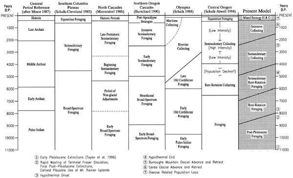
Most of Schalk's effort is given to Old Cordilleran foraging systems in the montane and marine context of the Olympic Peninsula. He notes widespread occurrence of willow-leaf shaped dart points with lenticular cross-section (i.e., Cascade points) [37] and, consistent with forager expectations, limited spatial or temporal intersite variability (Schalk 1988:90-91). He argues that a mobile foraging economy is particularly well suited to Northwest mountains, despite northerly latitude, due to the tendency of large ungulates to aggregate in the foot hills and intermontane valleys during the winter and to move to high elevation pastures during the summer. Accordingly, a high mobility rest-rotation foraging pattern shifting between relatively closely spaced upper and lower elevation landscapes, moving to new locations as local productivity declined, would have been well suited to the mountains so long as population density (hence, predation pressure) remained low. The early Holocene should have been particularly well suited to the low competition requirements of this Early Old Cordilleran Foraging pattern due to low population density and enhanced ungulate forage in the foothills during the Hypsithermal Interval.
Late Old Cordilleran Foraging (beginning circa 6,000 years ago) was intended to accommodate elevated resource stress caused by population increase and loss of ungulate forage at the end of the Hypsithermal Interval (see Table 2.3 on page 37). Forest expansion and elevated population density may have led to increased use of fire to reduce forest maturity plus "increased use of fish and littoral resources in the spring-summer-fall months for immediate consumption, increased residential mobility especially during the winter..." (Schalk 1988:103). Except for these changes, most groups should have maintained the uplands/foothills rest-rotation foraging pattern established earlier. However, in places where food stress was particularly severe and/or riverine resources particularly productive, foragers may have adopted collector characteristics–restricted mobility, reliance on over winter storage, logistic procurement and so on. Accordingly, the period may have witnessed existence of both forager and collector economies as groups came to grips with diverse regional population and resource dynamics.
Assuming that population density continued to increase, demands on ungulate resources ultimately reached level beyond which herds had sufficient predation-free time to recover. That is, restrotation periodicity became too short for game populations to rebound sufficiently to tolerate continued human predation. Faced with collapse typical of predator/prey relationships everywhere, successful human groups were those that developed strategies that intensively exploited alternative riverine and eventually marine resources. Because of the relative abundance and predictability of anadromous fish, and proximity of fisheries to montane hunting areas, river-based collector systems are expected to predate those focusing on marine resources.
The Olympic model anticipates disappearance of the last vestiges of high mobility foraging systems about 3,000 years ago with replacement by aggregated, semisedentary to fully sedentary communities focusing primarily on lowland based procurement and bulk storage of anadromous fish (Riverine Collecting). A shift to marine resources (Maritime Collecting) followed. Most importantly, Schalk (1988:150-151) suggests that upper elevation mountain use was dramatically reduced in favor of summer exploitation of lowland species. Ungulates, he believed, were better managed by permitting untouched summer grazing in subalpine habitats with hunting restricted to winter when elk and deer moved to downslope forage areas. He suggests that the virtual absence of late Holocene style projectile points in the available Olympic National Park montane sample was consistent with early to mid-Holocene use and marked reduction in late Holocene use of the uplands.
Schalk's Olympic model is discussed in some detail here because it was designed to accommodate mountain land-use approximately comparable to Mount Rainier, and because of two critically important, theoretically well-grounded assertions: 1) that Olympic and Cascade montane geomorphology and climate acted to aggregate game and minimize distance between winter and summer pastures sufficient to facilitate successful exploitation by early Holocene foragers; and 2) that use of upper elevation landscapes ceased, or was reduced dramatically, following development of collector land-use systems in the mid-Holocene. If the first assertion is true, then we should see unequivocal evidence of earliest mountain and mountain fringe use dating to the early Holocene. If the second assertion is true, then we should see a marked drop in upland archaeological materials dating to the late Holocene.
Multiple Strategy Intensification Models; The PEP Project
The final settlement and subsistence model considered before turning
directly to Mount Rainier and the southern Washington Cascades was
developed by Schalk and Atwell (1994) as part of the extensive Pipeline
Expansion Project (PEP) in Idaho, Washington, Oregon and northern
California. Because of its breadth of scope, the associated
archaeological sample was drawn from a wide variety of environmental
contexts. Because of regional variation in resource potential,
intensification processes may generate very different subsistence and
settlement responses across the greater region.
The PEP intensification model attempts to accommodate this variability by contrasting probable intensification trajectories in different subregions [38] in terms of five land-use strategies–1) Foraging; 2) Rest-Rotation Collecting; 3) Semisedentary Collecting; 4) Fully Sedentary; and 5) Equestrian Hunting and Gathering. Each of these strategies is contrasted in terms of three key variables: food storage, residential mobility and resource transport. Consistent with earlier use of the concept, the Foraging strategy assumes a fully nomadic land-use system (i.e., high residential mobility) with no systematic dependence on food storage (Schalk and Atwell 1994: [5]180). Related expectations include large range size, low population density, and winter season dependence primarily on animals killed for immediate consumption.
Rest-Rotation Collecting incorporates food storage in order to bridge brief periods of winter sedentism. A "key feature of this strategy is the regular rotation of settlements on a yearly or multiyearly basis to new areas to avoid the declining rates of return associated with continuous exploitation of the same areas" (Schalk and Atwell 1994:[5]19). To function properly, such systems depend on low population density and existence of open, competition free alternative foraging areas.
Semisedentary Collecting differs from the above largely by loss or absence of the rest-rotation option. In such systems, the annual range of winter settlement and warm season movement through a series of procurement camps can no longer shift to areas that have not been exploited in the recent past in order to alleviate declining productivity. Ostensibly, such restrictions result from elevated population density and competition for available space and resources (see Schalk and Atwell 1994:[5]20). A restricted long-term range implies that resources capable of withstanding repeated (i.e., intensive) exploitation will tend to be favored over those that cannot. Accordingly, subsistence patterns tend to emphasize bulk procurement of temporally or locally abundant commodities (e.g., acorns, camas, anadromous fish) with lengthened storage period and increased labor and redistributive costs. While the total spectrum of resources used may remain broad, effective niche width narrows by virtue of increased dependence on fewer critically important commodities (see Schalk and Atwell 1994:[5]21).
Fully Sedentary systems are the most labor intensive, residentially restricted systems modeled in the PEP report. In this strategy, "residential centers are occupied throughout the year. Intensive harvesting of resources within the day-radius provides most of the annual food supply" (Schalk and Atwell 1994:[5]21). Longer distance commodities may be acquired through trade networks. Niche width tends to be very narrow, storage requirements high, home range restricted, social organizational and redistributive mechanisms complex, and division and labor costs high. Such systems are rare among hunter-gatherers because undomesticated plants and animal populations seldom are capable of withstanding such intense pressure in the long-term. Essentially, hunter-gatherers cannot be fully sedentary without very abundant unearned resources (perhaps exceptionally prolific anadromous fisheries) and/or effective water-borne trade networks.
Finally, Equestrian Hunting and Gathering is intended to distinguish terminal prehistoric systems dependent on horse transportation. Newly acquired long distance travel options, occurring in close coincidence with extensive disease related social dislocation, spawned a variety of long distance hunting and trade systems that are difficult to classify other than by reference to dependence on the horse. In the southern Washington Cascades, huckleberry bulk processing and transport arguably became economically viable only after horses became generally available–particularly to east slope populations like the Yakama–about 250 years ago.
Because the pipeline route that spawned the PEP project did not cross the Cascades, no regional progressions were generated that are specifically applicable to Mount Rainier. Even so, one of the PEP model's most substantial contributions is its emphasis on regionally variable intensification trajectories. In some places, particular settlement and subsistence systems may be emphasized while others are absent altogether. In the highly seasonal, intensifiable resource limited northern Rockies, for example, Schalk and Atwell (1994:[5]24) predict maintenance of foraging strategies throughout the Holocene, only changing to equestrian-based rest-rotation collecting at about A.D. 1800. In the John Day-Deschutes drainage basins of central Oregon, they model a more complete sequence from foraging, to rest-rotation foraging, to semisedentary collecting, and finally, to equestrian hunting and gathering. Patterns in both regions reflect responses to population/resource dynamics operative in environments with very different intensification options.
It is important to note that the PEP model assumes that, while organizational responses may vary, the general tendency is directed toward greater land-use intensification, logistic reorganization and increasing social complexity through time. In so doing, the model remains consistent with general forager/collector expectations. Its greatest refinements lie in directing our attention to subsistence and settlement variability that may be hidden within simple forager to collector jargon, in accommodating regional land-use variation within a single scheme, and in building a compelling ecological foundation in support of its arguments.
An Intensification Model for Mount Rainier and
the Southern Washington Cascades
To this point, discussion has focused on theoretical background linking human and environmental systems, with particular emphasis on basic causes of organizational change in subsistence and settlement systems through time. Particular attention has been given to implications of human population density relative to the distribution, density and seasonality of critical resources–particularly ungulates and anadromous fish. I suggest that chronic shortfalls in availability of key resources induced primarily by increasing regional population density and/or resource degradation have over the long-term been met by increasingly intensive use of the landscape. That is, as the Holocene progressed, population and resource variables interacted to create selective contexts favoring development and continuance of land-use systems capable of extracting and distributing increasing resource levels from fixed or declining territory.
Substantial attention also has been given to providing background to intensification models which attempt to describe and explain basic processes of change in subsistence and settlement systems in the Pacific Northwest. I have focused on Binford's (1980) forager/collector ideas as the intellectual foundation for these approaches not so much because his views can be applied uncritically or without modification, but because 1) of their capacity to subsume critical organizational elements of both ends of the hunter-gatherer continuum; 2) of their predictive power for basic site type and distribution patterns; and 3) they constitute a baseline, widely referenced approach with established application to regional prehistory. Examples have been given of intensification models built on this foundation to develop familiarity with the approach, provide a "road map" through changing nomenclature, and, hopefully, convince the reader of their value as a framework for interpreting long-term patterns in human use of the region. Figure 5.2 compared these models, as well as the one proposed for Mount Rainier and the southern Washington Cascades.
The present model predicts patterned change in subsistence and settlement systems from early Holocene hunter-gatherers moving between resource patches as small, residential groups with minimal reliance on bulk procurement and storage (foragers); to late Holocene populations obliged to reside, at least seasonally, in sedentary villages reliant on over winter storage and relatively complex resource procurement and distribution strategies carried out to varying degrees by task-specific collection groups tethered to the village center (collectors). The model is organized into six temporal stages which summarize basic subsistence and settlement characteristics expected to dominate the region for the indicated time period. Also included are implications for the archaeological record of the southern Washington Cascades and Mount Rainier National Park. Nomenclature has been selected to maximize compatibility with existing intensification models while incorporating parameters (particularly mobility and rest-rotation options) considered to be of central importance to prehistoric subsistence and settlement patterns.
It is important to recognize that this, and all models, simplify reality. They smooth intergroup organizational variability and understate system dynamics taking place within each of the temporal periods. The advantage of simplification lies in the capability of a macroscopic view to clarify patterns within more complex systems' states, and to isolate (we hope) basic causes underlying development and change in human subsistence and settlement systems through time. Because of theoretical grounding and links to objectively observable phenomena, we can move beyond speculation about the past to use of the archaeological record as a data source for testing and rejecting or refining the land-use patterns proposed.
Post-Pleistocene Foraging (>11,000 to ca. 8,000
B.P.)
Environment
Terminal Pleistocene floral and faunal
patterns across much of northern North America were regionally variable
and dynamic. On the Columbia Plateau east of the Cascades, the climate
was cooler and drier than present. The region supported a variety of
large bodied fauna including mastodon, bison and caribou which, along
with a variety of smaller species sharing similar habitat requirements,
declined to extinction as the climate warmed and human predation began
(see Schalk and Atwell 1994 and Gustafson et al. 1979). According to
Taylor et al. (1996:516), initial extinctions may have begun about
11,000 years ago. Bison antiquus may have been the longest
surviving of the large Pleistocene grazers, declining to extinction
circa 8,500 to 8,000 years ago.
Abundance of these herds in the Pacific Northwest and their capacity to sustain human predation, is difficult to establish. However, given the tendency of the region's bunch grass prairies to degrade under heavy grazing pressure (Mack and Thompson 1982), it is reasonable to assume that density of these megafaunal grazers was more limited here than on the high plains further east. Even so, scattered distribution of large fluted Clovis-style lance points typically associated with exploitation of these animals suggests human presence in the Columbia Plateau and eastern Cascades foothills, probably focused on exploitation of early post-Pleistocene megafauna and other habitat-sharing species.
West of the Cascades, plant and animal communities appear to have dispersed into previously ice mantled areas of the Puget Trough and Olympic Peninsula during the Everson Interstadial circa 13,500 to 11,000 years ago. This period may also have witnessed colonization by some Pleistocene megafauna. It is plausible that the elephant excavated at the Manis Mastodon Site near Sequim on the drier east flank of the Olympics (Gustafson et al. 1979) is part of a population established during this time period.
Glacial ice advanced again during the Sumas Stade, pushing megafauna habitat further south into the southern Puget Trough (or eliminating it altogether). The ice retreated rapidly after about 9,500 years ago, allowing rapid development of dense lodgepole pine forest succeeded by more nearly modern floral associations.
In the Cascades, the Cordilleran ice mantle retreated dramatically during the Everson interglacial, opening lower elevation passes such as Snoqualmie north of Mount Rainier. On Mount Rainier itself, McNeely drift (a.k.a. Sumas Stade in the Puget Trough) ice again advanced down the major river valleys, lowering the snowline to about 5,900 ft. At this elevation, most of the Park's larger mid-elevation ridges, cirque basins, tarn fields, and open parklands would have lain under perpetual snowpack or been subject to vegetation depleting impact of extended snowpack and frost heaving (see Chapter 2). It is likely that nearmodern floral associations became established briefly during the Everson Interglacial, retreated during the Sumas (McNeely) advance, and were established again following Sumas retreat circa 8,500 years ago.
Land-Use
The first colonizing populations probably
penetrated the continent south of Alaska during the Everson Interglacial
circa 13,000 to 11,500 years ago [39]
following the movement of Pleistocene megafauna south through an
ice-free seam between cordilleran and continental ice masses east of the
Canadian Rockies. Though controversy remains as to timing of initial
colonization, a selected suite of 20 firmly dated and calibrated Clovis
and Folsom assemblages scattered across the continental United States
(Taylor et al. 1996) are consistent with this time frame. It is
reasonable to expect some of these colonizing populations to have spread
into the Northwest during terminal Pleistocene and very early Holocene
times. Human activity, however, was most likely focused on megafaunal
habitats on either side of the mountain– particularly the Columbia
Plateau.
Schalk and Atwell (1994:[5]88) argue that no securely dated cultural remains in the Northwest predate 11,000 B.P. Nonetheless, presence of Pleistocene megafauna and early fluted points attests to an early post-Pleistocene human presence across the broader region A few of these points have been found in the Cascade fringe. Northeast of Mount Rainier, a Clovis find near Cle Elum suggests early human presence in the general Snoqualmie Pass area (Hollenbeck and Carter 1986:26). Note, however, that other than the East Wenatchee Clovis Site (45DO482), Clovis or other early Holocene sites in the Northwest have been found only in surface or compromised contexts, making their age difficult to establish unambiguously. Unfortunately, radiocarbon dates on bone from the East Wenatchee site did not return early Holocene ages. Even the Manis Mastodon Site lacked clear association with diagnostic artifacts, though presence of a single used flake plausibly (if uncertainly) indicates human presence in the Puget Trough perhaps as early as 12,000 years ago.
On Mount Rainier, open forest/tundra habitats probably became established as early as 12,000 B.P. on its lower to mid-elevation flanks. Most economically important Holocene fauna probably became established during this period as well. These habitats would have retreated downslope during McNeely Drift times and advanced again as ice retreated circa 9,000 to 8,500 years ago. It is possible that earliest human use of the lower southern Washington Cascade passes dates to the post-Pleistocene period. Use of Mount Rainier itself is less likely. However, most foragers probably focused on the most productive megafauna habitats east, and to a lesser extent west, of the Cascades. Montane game density would have been too low and exploitation costs too high to have attracted significant use by the few human groups entering the region during post-Pleistocene times. The probability of human forays into the midst of the southern Washington Cascades and onto the flanks of Mount Rainier increases sharply with massive glacial retreat and establishment of modern plant and animal communities after 8,500 years ago.
The Archaeological Record
For the southern Washington
Cascades, archaeological evidence of human occupation should be minimal
and restricted to lower elevation passes. To date, the Cle Elum Clovis
find is the only very early fluted point form plausibly linked to
montane landforms in this region. Because of its surface context, the
age and even location of original use cannot be determined
unambiguously. Even so, its location near Snoqualmie Pass is consistent
with post-Pleistocene foraging in the eastern Cascades foothills and/or
with cross-Cascades travel at an early date.
Extant radiocarbon data are consistent with these expectations. The earliest, plausibly culturally related, radiocarbon age presently known in the southern Washington Cascades is a circa 8,500 B.P. date recorded near the Cedar River north of the Park (see Table 3.4). Cultural deposits radiocarbon dated to the mid 6,000s B.P. are common (see Table 3.4), more firmly establishing human presence by this time. Currently, the oldest known site on Mount Rainier proper is the Sunrise Ridge Borrow Pit (45PI408), containing lithic debris sandwiched between 2,300 year old Mount Rainier C and 3,400 year old Mt. St. Helens Yn tephras. For Mount Rainier National Park, however, cultural remains are not expected to date terminal Pleistocene or very early Holocene times prior to 9,000 B.P.
Rest-Rotation Foraging (ca. 9,000 to 6,000 B.P.)
Environment
Environmental parameters for the period have
been anticipated above. During these three millennia, the earth
rebounded from its long Pleistocene glacial episode (albeit with
interglacial breaks) and entered a protracted period in which the
general climatic conditions were measurably warmer and drier than
present. In lowlands like the Puget Trough, forest succession was
arrested or reversed as an increasingly xeric climate selected for
brushier, more open forest stands. In the Cascades, tree-line crept
further upslope, plausibly reducing the size of subalpine habitats as
permanent snowline moved upslope and growing season lengthened. Assuming
fire frequency remained stable, ungulate habitat would have improved in
the lowlands and Cascade foothills, while it became more restricted at
higher elevations.
The onset of the period is keyed to extinction of the last of the Pleistocene megafauna and full development of characteristic Holocene plant and animal communities in the Northwest. In the high Cascades, Cascade foothills and surrounding lowlands, near modern floral and faunal patterns became well established except as affected by Hypsithermal warming. Included are species believed to be of particular economic importance for hunters and gatherers now deprived of larger megafauna alternatives–elk, deer, mountain goat, bear, marmot, game birds, camas, huckleberries, and so on. Mountain sheep also appear to have been present during much of the prehistoric period. Anadromous fish populations are expected to have become reestablished in most Northwest watersheds.
Land-Use
Human population density is expected to have
increased slowly but remain at relatively low levels during the early
Holocene. With extinction of Pleistocene megafauna, resource
productivity on the Columbia Plateau declined substantially. Even at low
population density, extinction of these large animals should have
induced increased use of a broader resource spectrum focused
particularly on the habitats of the most productive surviving
ungulates–ostensibly elk and deer. Assuming that the densest
distributions of these ungulates were biased toward Cascade foothills
and surrounding lowland landscapes, it is reasonable to expect their
human predators to have increased their presence in these areas as well.
Accordingly, the model anticipates that Pleistocene extinctions were
associated with punctuated increase in hunter-gatherer activity in the
Puget Trough and southern Washington Cascade foothills east and west of
the range.
Lowlands and Cascades foothills are emphasized because of the presumed impact of the Hypsithermal climate on forest structure. If ungulate habitat became more productive in the lowlands and simultaneously less productive in the uplands due to forest encroachment, then it is reasonable to expect human populations to have focused attention on low to moderate elevation landscapes with less attention to high elevation places. Given the combination of relatively low predation pressure (low human population density), productive lowland habitats, and tendency of game to aggregate in mountain foothills (Schalk 1988:90-91), hunter-gatherers probably emphasized use of valley and foothill environments throughout the period. Use of subalpine uplands, such as those on Mount Rainier, is also possible. However, relative difficulty in entering these areas, and absence of compelling need to do so on a regular basis, probably combined to limit use until later in the Holocene. [40]
The period title reflects subsistence and settlement patterns expected to have characterized the region from circa 9,000 to 6,000 years ago. Because of high game density relative to demand and tendency for ungulates to aggregate in open lowland and foothill habitats, it should have been possible to sustain a foraging strategy with relatively short distance residential moves and minimal dependence on bulk processing and storage. Foraging may have focused on a broader spectrum of resources relative to the Post-Pleistocene period, but plants and animals selected are expected to be dictated by seasonal availability and proximity to ungulate hunting areas. Rest rotation refers to the capacity of groups to move to new foraging areas as hunting productivity declines, thereby allowing predation-free time for game density to regenerate naturally. Ability to do so depends on availability of abundant open space with minimal resource competition by other groups. The pattern is of key importance to maintaining a forager strategy, because it insures resource stability without sophisticated logistic strategies or intergroup coordination. In an environment like that of the Pacific Northwest, I believe that it is only practical in a context of very low population density and high resource abundance.
Archaeological Record
No sites have yet been dated to the
9,000 to 6,000 B.P. period in Mount Rainier National Park. While it is
possible that such sites eventually will be found, strict application of
the present model suggests that such sites will be rare. Without
intentional burning to enhance upland forage (considered unnecessary in
the low population/abundant resource context of the early Holocene),
foraging activity should have emphasized lower elevation foothill and
valley landforms. These sites should be limited in size but contain a
functionally varied array of artifact classes consistent with
residential use.
Radiocarbon dates from sites in the southern Washington Cascades (see Table 3.4) are strongly consistent with human presence in these contexts near the close of the period. A circa 6,250 B.P. radiocarbon date from an obsidian quarry in alpine context (45LE285 at Elk Pass) also suggests at least limited early use of higher elevation landforms dating to the close of the period. Additional research geared toward developing a larger set of dated upland sites in firm stratigraphic context will be useful for determining the extent to which land-use emphasized lower elevation landscapes as predicted here or incorporated subalpine habitats, requiring modification of model expectations. Ostensibly early "diagnostic" artifacts, such as leaf-shaped Cascade style dart points, are not sufficiently temporally sensitive to establish early Holocene time frame in the absence of firm stratigraphic or chronometric supporting data.
Semisedentary Rest-Rotation Foraging (ca. 7,000 to 4,000
B.P.)
Environment
Present data suggest that the Hypsithermal
Interval gave way to a period of generally cooler and moister conditions
about 5,000 to 4,500 years ago–conditions that persist with
shorter-term perturbations to the present. Termination of the
Hypsithermal had significant, but opposite, effects on lowland versus
upper montane forest structure. In lowland valleys and foothills, forest
cover became more uniform and began to approach more nearly closed
canopy cover. That is, overall ecosystem maturity increased toward the
Maritime Forest pattern that now dominates the region. In these areas,
ungulate forage should have been restricted by the shrinking size and
number of grassland and brushy habitats.
In the mountains, where upper elevation forest cover is controlled more by snow pack and growing season than by moisture, forest cover should have retreated downslope to approximatly present elevations. Increasing expanses of alpine tundra, and subalpine parklands should have attracted correspondingly increased numbers of elk and deer during the late summer months when forage was at its peak. Coincident degradation of forage in the lowlands with seasonal improvement in the uplands is expected to have contributed substantially to punctuated increase in human use of places like Mount Rainier National Park during this time frame.
On Mount Rainier, climatic impacts are complicated by Holocene vulcanism. The mountain experienced a particularly destructive series of volcanic events beginning about 6,600 years ago and culminating in the massive Paradise-Greenwater-Osceola mud flows circa 5,000 to 4,500 years ago (Harris 1988, Scott et al. 1995). These events removed circa 2,000 ft from the summit, altered landscapes on the mountain's northeast and eastern slope and inundated the White River floodplain almost to Tacoma (see Figure 2.2).
Land-use implications of mid-Holocene volcanic events are difficult to gauge. Clearly the summit collapse and larger lahars were catastrophic events destroying plants, animals and people unfortunate enough to be in their path. However, early succession processes involving growth of rapidly reproducing grasses and brushy plants most valuable as ungulate forage generally began immediately. Succession may be well advanced in several years. It is likely, then, that habitat destruction was short-lived and followed quickly a slightly longer period of ungulate habitat improvement. Accordingly, I assume that these events, while dramatic, did not significantly affect (and certainly did not reduce) forager use of the uplands or major lowland river valley in the long-term scale with which we are dealing.
Land-Use
To accommodate low but gradually increasing
population density and loss of lowland and foothills ungulate habitat at
the end of the Hypsithemal Interval, Northwest groups should have
increased exploitation of a wider range of variably productive habitats,
including higher elevation montane landscapes. Consequent changes in
foraging strategies are expected include limited sedentism and storage
to bridge short-term winter food shortages. It is reasonable to expect,
however, that competitive resource pressure was not yet high enough to
cause loss of at least two options central to forager production:
continued existence of enough uncontested territory to maintain rest
rotation movement, and ability to move to most resource patches as full
residential units rather than as limited-task groups tethered to larger
central villages. In essence, the model assumes that mobility became
restricted slightly by incorporation of limited bulk harvest and storage
activities, but not enough to lose rest-rotation and full residential
movement options.
As noted above, forage should have become more productive in the uplands as forests retreated downslope to near modern elevations. Accordingly, use of subalpine and alpine zones on Mount Rainier and the southern Washington Cascades is expected to increase as a direct consequence of their increased foraging value.
In short, the most salient aspects of the forager strategy (e.g., small group size, relatively frequent residential moves, minimal bulk processing and storage, limited intersite variability) are expected to remain region wide. However, combined population and environmental circumstances are expected to have operated to cause 1) settlement in less optimal habitats, 2) increased variability in foraging strategies, 3) short-term bulk processing and storage, and 4) punctuated increase in use of upland habitats coincident with environmental cooling at the end of the Hypsithermal Interval.
Archaeological Record
Site types should remain roughly
comparable to those from the early Holocene, but with 1) a higher site
total consistent with increased regional population density, 2)
dispersal into a wider range of habitats on both sides of the mountains,
3) increased representation in montane uplands, and 4) a fraction of
larger, more complex sites in lowland settings with evidence of storage
facilities or use of resources such as anadromous fish, camas and/or
other storable plants and animals. Site density in Mount Rainier
subalpine and alpine zones should increase abruptly, particularly as the
Hypsithermal climate weakened in the second half of the period.
An increased number of radiocarbon aged montane sites dating between about 5,500 and 6,500 B.P. (Figure 3.5) is essentially consistent with these expectations. Unfortunately, an insufficient number of securely dated sites is available from subalpine contexts to address the expectation of punctuated increase in use of high elevation settings in a meaningful fashion. Because of its growing number of documented sites and substantial subalpine and alpine habitat, Mount Rainier may offer an unusual opportunity to investigate expected environmental and land-use changes. Environmental patterns could be addressed through pollen core extraction and paleoenvironmental reconstruction. Land-use changes can be examined through test or data recovery excavation at a set of upper elevation site locations.
Semisedentary Collecting (ca. 5,000 to 1,500 B.P.)
Environment
This period saw full termination of the
Hypsithermal Interval followed by oscillating, but generally cooler and
moister climatic conditions as shown on Table 2.3. Forest density in the
lowlands and western foothills, if unaltered by fire, should have
continued in a high maturity state with concomitant limitations to
ungulate forage. Subalpine to alpine plant and animal communities should
have remained at approximately modern levels. Indeed, both uplands and
lowlands probably appeared essentially as they do at present, except as
modified by fire and short-term climate changes.
Massive volcanic events had lowered Mount Rainier's peak and altered upper elevation landscapes and major river valleys at the beginning of the period. About 2,500 years ago, a second volcanic cycle rebuilt the summit to is present height. It also deposited from one to eight inches of tephra (Mount Rainier C) over much of the mountain's northern and eastern flanks (Crandell 1987:14-15). Vegetation alteration and land-use implications of this event, however, appear to have been insignificant (cf., Dunwiddie 1986). Most of the volcanic activity took place in the summit caldera at elevations of little consequence to human use of the mountain. Effects of tephra deposits on northeast slope plant and animal communities certainly were less significant than original summit destruction about 2,000 years earlier. Accordingly, Mount Rainier C events probably had negligible effect on settlement and subsistence practices on the mountain and across the broader region. Similar expectations hold for land-use effects of earlier Mt. St. Helen's series Y eruptions occurring between 3,250 and 4,000 years ago.
In general, there is no indication that mid-Holocene environmental circumstances improved the regional resource/population equation. Subalpine habitats, because they are limited in total area, are not likely to have compensated for lost winter forage in the lowlands and foothills. In a natural state, ungulate population density, particularly on the wetter westerns slope, should have decreased overall.
From a human standpoint, lost ungulate habitat probably was not critical so long as population density remained low relative to abundance. By about 4,000 years ago, however, it is likely that demands on available resources reached a point beyond which they could be reliably met with previous hunting and gathering strategies carried out by small autonomous forager groups. It is assumed that combined impact of rising human population density and restricted ungulate habitat constituted an environmental context favoring 1) increased use of fire to expand ungulate habitat, particularly in lowland and foothill settings; 2) loss of rest-rotation options; 3) more intensive reliance on mass harvested and stored anadromous fish and other storable commodities; 4) loss of residential mobility; and 5) logistic reorganization consistent with intensive land-use requirements.
Pacific Northwest Forager to Collector Land-Use Changes
A
shift to winter reliance on mass harvested and stored anadromous fish is
the key element underlying land-use change from the high mobility
foraging pattern to the limited mobility collector pattern that
dominated Northwest hunter-gatherer economies in the latter part of the
Holocene. The model assumes that between about 5,000 and 4,000 years
ago, elevated population density and declining ungulate habitat reached
a point at which competition for available resources was too high to
reliably sustain restrotation foraging practices. Loss of rest-rotation
recovery options set up a positive feedback response, quickly leading to
over predation and precipitous decline in game abundance. In this
context, foraging land-use systems, critically dependent on closely
spaced resource patches and high game abundance relative to population
density, became untenable; causing a rapid shift toward logistically
organized subsistence and settlement strategies centered on major salmon
bearing rivers and streams (cf., Schalk 1988:99-104).
There are only a few Pacific Northwest resources capable of meeting bulk acquisition and storage requirements needed to bridge winter shortfalls and withstanding continuous intensive use without collapse. Foremost among these is anadromous fish. Others include winter collected marine resources, camas in very productive habitats, and perhaps wapato and biscuit root in places where they grow best. Anadromous fish, however, offer the highest return for effort of the available options. Salmon bearing streams are widely distributed across the region, the oceanic growth cycle supports very large populations, runs are predictable in place and time, and food return per harvest event can be high if labor is sufficient. Despite these qualities, there is compelling reason not to expect mass harvest and storage of anadromous fish before being forced to do so. Large-scale salmon procurement and storage is a labor intensive undertaking entailing loss of residential mobility through an extended harvest and storage period. As a central feature of a collector economy, it also involves a host of subsistence and social adjustments. Schalk (1988:98-99) describes costs and risks of dependence on mass harvested salmon as follows:
The costs of food storage in this environment are quite high... Due to the high precipitation and humidity as well as the mild winter season temperatures, effective storage of fish through desiccation or through freezing is impractical. Saturation of fish flesh and oils with the phenols in wood smoke (Schalk 1984) was essential to effective storage of oily fish like salmon. To effectively store salmon in this environment for winter consumption requires technology for mass harvest, appropriate structures for smoking the fish, containers and sheltered space for storing it, and large inputs of human labor spanning the entire interval from the time the fish are caught until eaten months later.
There are also risks involved in dependence upon stored foods to survive productive lows. Poor runs or even run failures occur naturally and, even if very infrequent, would have necessitated fall-back strategies. Perhaps a greater risk though is the potential that fish successfully stored may not be successfully consumed. Spoilage, loss to predators and scavengers and even loss to other human groups are some of the more obvious sources for this kind of risk.
It was costs and risks such as these that made reliance on mass harvest and storage of anadromous fish undesirable prior to onset of chronic resource related needs to do so. Intensive use of marine resources entails even greater liabilities. According to Schalk (1988:109):
...the more productive marine resources are only seasonally available and tend to be restricted in abundance or entirely unavailable during the winter months. Added to this are ...accessibility problems... The weather can be stormy for days on end making travel by watercraft difficult or impossible. Many shellfish are only available at low tide and ...during the winter months [the tides] are not as low as during the spring and early summer and they occur at night time.
Plants do not fare any better than marine life as over-winter stored staples. Suitably productive habitats, while locally important in the absence of anadromous fish, are too few and far between to sustain a region-wide forager to collector shift. Camas, arguably the most valuable of the plant staples, entails high harvest and preparation costs and requires a long storage period (see Thoms 1989). Bulk storage of plant products generally entails greater labor and storage costs due to the need to collect, process and store larger quantities than their salmonid equivalents. Furthermore, because of intensive harvest needs, other than in exceptionally productive areas, non-horticultural plants cannot sustain intensive long-term use in the absence of alternative resource supplements.
Largely due to widespread availability and sustainable productivity, anadromous fish were therefore most plausibly the earliest resources relied upon for over-winter mass storage. Schalk (1988:110) suggests that initial settlement should have been geared toward larger rivers providing stable fisheries in areas that also maximized continued access to ungulate procurement places. Through time, we should see progressive expansion onto less productive streams, followed by adoption of lower return resources as intensification pressure continued to increase.
Once required to change to primary subsistence reliance on mass processed and stored fish, remaining characteristics that define collector systems fall into place. Perhaps the most important change is to nearly sedentary residence in relatively large aggregated villages. With a fishing dominated economy, residence is restricted to riverine settings from autumn through winter by the extended procurement and storage needs that anadromous fish entail. Group size increases to accommodate higher regional density overall and meet elevated labor requirements. Indeed, increased population may be expected to closely follow a shift to collector (or agricultural) strategies, in part, to meet these new labor demands (cf., Schalk 1988:111).
Because of large group size and scheduling requirements related to reliance on anadromous fish, collectors forfeited the capacity to move freely across the landscape as a residential unit at times at times optimal for procurement of non-salmonid resources. Late summer to fall use of subalpine habitats, for example, conflicts directly with salmon harvest and storage in the lowlands. In short, sedentism, bulk storage, group size, scheduling requirements and degraded game habitat combine to force a shift to a full collector systems in which relatively few resources become the central focus of attention and supplemental resources are either sought by limited-task groups tethered to the residential hub or are supplied by trade. There is no middle ground. Even social complexity must increase to regulate the more involved tasks required to sustain larger groups in limited territory.
Changes to Montane Land-Use Patterns
Widespread adoption
of riverine collector strategies implies primary settlement and
subsistence focus on lowland and foothills settings through most of the
year. Due to presence of upstream barriers, productive salmon runs
seldom penetrate deeply into high elevation landforms, and almost never
in close proximity to subalpine habitats. As discussed in Chapter 2,
anadromous fish were probably never an important resource in Mount
Rainier National Park. Subalpine to alpine habitats, arguably once a
normal part of the forager seasonal round, became logistically
challenging areas at the margin of effective resource gathering
territories tethered to lowland villages. Transportation difficulties
inherent in using upland habitats were not great so long as game was
plentiful and used primarily to supply immediate consumption needs.
Costs increased sharply, however, in a context of depleted game and use
by collectors charged with transporting resources back to a distant
residential base.
In his Olympic Peninsula study, Schalk argues for declining use of the uplands during the late Holocene.
Early in the ...project it was postulated that subalpine areas were likely to have been used more intensively during the early and mid-Holocene than after the emergence of semisedentism in the region (Schalk 1985). This expectation derives from the fundamental differences between land use systems that emphasize residential mobility versus those which emphasize logistic mobility. The implication ...is that native usage of the Olympic mountains prior to the appearance of the riverine and maritime collecting systems involved systematic exploitation of resources in Zone IV [Subalpine and Arctic]. After the appearance of the collector systems, however, the focus of exploitation shifted downward in elevation onto the ungulate winter ranges that are generally below 2,000 ft in Zone II [River Valleys and Lowlands] (Schalk 1988:150). [Zone titles added.]
Schalk (1988:151) goes on to suggest that available archaeological data from Olympic National Park were consistent with a bias toward early Holocene use. Later, during the Mount Rainier project, he reemphasized the point verbally; arguing that optimal foraging principles lead to the expectation that the most efficient season for exploitation of ungulates would be winter when these animals are at relatively low elevations and when scheduling conflicts with other subsistence activities would be minimized. After moving back downslope, game could be taken nearer the residential base in the winter season when food need was highest. Subalpine zones essentially would serve as unmanaged summer pasture land where elk and deer could fatten for later use.
The arguments make sense. Interestingly, compelling as they may be, they are not consistent with archaeological data from Mount Rainier. Extant Mount Rainier data presently lack clear evidence for very early use. More significantly, radiocarbon dated sites, wide distribution of arrow-sized projectile points and presence of cultural debris atop 2,300 year old Mount Rainier C tephra leave little doubt that upper elevation Mount Rainier and southern Washington Cascade landscapes continued to be used throughout the Holocene coincident with full development of collector strategies in the lowlands.
This deviation from expectations despite compelling optimal foraging arguments to the contrary provokes intriguing land-use possibilities that must be accommodated in the model. I suggest that use of high elevation places did indeed decrease on a per capita basis, but that use of subalpine landscapes can be expected to continue for one or all of three reasons: 1) uplands could not be left as unmanaged pasture land in a population packed region without being further degraded by "cheaters", and/or 2) marginal populations continued low intensity forager practices on the fringes of increasingly centralized lowland society, and/or 3) limited task groups tethered to lowland villages acquired high return commodities not available in the lowlands.
Garrett Hardin, an ecologist who developed much of the competition theory imbedded here, also advanced explanations as to why unmanaged resources tend to degrade to crisis levels when used in common by people lacking clearly defined mutual obligations. In Tragedy of the Commons, Hardin (1968) uses the example of pasture land commons in Britain to argue, in essence, that such circumstances always serve to the selective benefit of over-users. That is, "as long as a pasture [or any other resource] is considered to be unlimited and for common use by everybody without constraints, then ...overuse is inevitable since the individual gains a temporary advantage by overstocking [or overuse] and only at some later time ...begin[s] to suffer the collective consequences of overuse" (Odum 1971:245). In this light, the expectation that Mount Rainier's subalpine "pastures" will be left untouched by linguistically and socially distinct groups on all sides of the mountain with, at best, marginal obligations to one another is unreasonable. Despite its degrading state, it is more reasonable to expect a) marginal groups to continue to exploit remnant resources at a low level and/or b) groups dependent on winter hunting to establish territorial rights over critical portions of the uplands and protect them from overuse. In the latter case, limited task groups may have been dispatched to the mountains less to collect and return stores to lowland centers, than to insure that ungulate resources return to the lowlands with the onset of winter.
In addition to protecting montane resources or continuing exploitation by marginal foragers on the fringes of collector dominated society, is the possibility that late Holocene hunting focused less on ungulates and more on alternative high value resources such as mountain goats (wool), marmots (fat) or huckleberries (dried) that are not available in the lowlands. Because of transportation difficulties and scheduling conflicts noted above, it may be impractical to expect these resources to be taken in abundance unless affiliated with other land-use needs as outlined below or prior to transportation enhancing introduction of the horse.
Recognizing the dangers of a complex scenario, I suggest that a combined explanation is most plausible. It is likely that early in the Semisedentary Collecting period, upland ungulate hunting continued to be carried out by a decreasing number of marginal forager groups. As resource pressure mounted, lowland groups extended territorial rights over critical watersheds and upland summer game habitats. This assumes that ultimately, benefits of protecting game populations became great enough to warrant the costs of dispatching limited-task groups to protect territorial/resource rights during the critical late summer months. To be effective, it would have been necessary to extend protection over a circa two month period. Accordingly, such groups would have been obliged to establish residential base camps (very likely much the same as foragers), carry out low-level maintenance hunting while in upland residence, and ultimately return to the lowland center in late autumn with the highest value for weight commodity(ies) available on the mountain.
In short, it is reasonable, indeed expectable, for human use of the mountains to continue throughout the Holocene, albeit on a restricted per capita basis and oriented to fill different social/economic needs. Rather than use dominated by mobile mixed sex and age residential groups, the mountains became tied into more complex land-use practices ancillary to intensive use of riverine resources in the lowlands. Changing mountain land-use practices were part of a regional shift in settlement and subsistence practices from forager dominated systems fit to a context of low population density relative to terrestrial game abundance; to collector systems better able to cope with increasing demand and restricted availability of wild terrestrial resources.
Archaeological Record
The present archaeological record of
Mount Rainier and the southern Washington Cascades leaves little doubt
that human use of the uplands continued throughout the Holocene. What
remains is not to debate the fact of continuing uplands use, but rather
to address how land-use practices may have changed and how those changes
affected the archaeological record. Interestingly, it is possible–I
believe probable–that site type and distribution patterns in the
mountains may not appear to be substantially different if forager and
collector land-use practices developed as outlined above. Due to the
need to maintain upland residence during the subalpine/alpine summer,
factors affecting site selection and use may have been much the same in
early through late Holocene times. Because of occupation length, both
foragers and collectors would have been obliged to establish residential
base camps in settings fit to unpredictable high elevation weather
patterns. Both foragers and collectors probably operated out of these
camps through a series of task-specific resource acquisition locations
or information stations. Differences between the two systems may lie
largely in 1) the social composition of the groups; 2) the suite of
upland resources sought; and 3) the composition of tool kits and
features employed in carrying out these tasks.
Due largely to the need to maintain extended residence, archaeological signatures differentiating early from later sites are expected to be subtle. Each of the three areas of variation noted above may be detectable in the archeological record given directed research and a large enough sample size. For example, the expectation of differences in social composition assumes that earlier forager groups would have sex and age range reflecting the full social unit in residence on the mountain. Collector residence is more likely to consist of a subset of the larger population, the remainder of which would have been occupied by lowland tasks in the late summer. Unfortunately, because maintenance and food preparation tasks may have been varied in both cases and because both may have selected similar base camp settings (I have proposed the upper forest/subalpine ecotone), the archaeological signatures may be similar. Indeed, it is possible that mixed sex and age groups may have used the mountain through time, even if representing a social subset in later times. Archaeological variation, if any, must be the subject of empirical investigation. I suggest that most robust early to late Holocene changes will lie in other archaeologically observable domains.
If the resource arguments above have merit, the greatest single source of variation between early and late sites should lie in the relative proportions of game animals sought and, in principle, preserved in the archeological record. All else being equal, early Holocene deposits should contain a high fraction of large ungulate remains (principally elk and deer). Late Holocene collector components should show a higher fraction of smaller animals, including particularly a higher fraction of remains linked to potentially high value transportable commodities–goat and perhaps marmot remains.
Potential change in artifact and feature complexity associated with early versus late Holocene land-use practices reflects the need to maintain high residential mobility with relatively low site reuse among foragers versus greater potential for redundant site use and exploitation of a somewhat broader range of resources among collector groups. To accommodate high residential mobility, forager tool kits should be small, portable and suited to multi-functional applications centered on the need to kill and butcher large body-sized animals. Such needs may characterize later Holocene use as well, but modified by incorporation of a higher fraction of small body-sized game, greater functional variability among site types, and enhanced potential to reuse site locations and thereby lessen transportation weight by caching tools. With lessened weight restrictions and a potentially greater number of tasks to be performed, tool kits should be more complex and contain implements such as arrows, darts and distinct butchering tools suited for extraction of wider size ranges without as pressing a need for multi-functional portability. Feature variability may increase in the later Holocene as well; particularly if goat hunting (high elevation blinds) and huckleberry processing (fire drying features) become integrated into the range of upland tasks.
Unfortunately, extant data do not allow us to address possible early to late Holocene site variation patterns in more than an impressionistic sense. It is interesting that, despite currently limited research in the Park, at least three sites have qualities consistent with the general tenor of the collector end of the land-use continuum. Goat (or sheep) teeth at Fryingpan Rockshelter excavated from sediments circa 1,500 to 2,500 years old are the only firmly identified faunal remains yet obtained from the Park. Artifacts from the 2,300 to 3,400 year old Sunrise Ridge Borrow Pit site are consistent with residential base camp expectations and include a ground stone hammer not expected in portable forager assemblages. Artifacts dating to the last 1,200 years at Berkeley Rockshelter, show substantial diversity including both dart and arrow sized projectile points, suggesting a mixed hunting strategy late in the Holocene.
Clearly, existing Mount Rainier archaeological data are too limited to constitute a rigorous test of expectations offered here, particularly in the absence of any clearly early to early middle Holocene components. It is likely that present absence of early sites is a product of poor site visibility due to mid-Holocene vulcanism and limited subsurface archaeology in the Park. With currently available information, it is clear that extensive use of Mount Rainier subalpine to alpine habitats took place during the last 3,000 years. It is reasonable to believe that such use extended at least several thousand years deeper into Mount Rainier's prehistoric past. I suggest that it is reasonable to model processes underlying such use as outlined above. Refinement of these ideas in light of concrete archaeological data awaits directed research to that end.
Intensive Collecting (ca. 2,500 to 400 B.P.)
Environment
Late Holocene climatic conditions remained
relatively cool and included an acute glacial advance between about 900
and 500 years ago (the Garda Stade on Mount Rainier). The extent to
which this advance influenced resource patterns is difficult to
determine. All else being equal, high elevation ungulate forage should
have been improved by snowpack suppression of forest cover, while low
elevation forests expanded in response to increased moisture overall. On
strictly environmental grounds, there is reason to expect seasonal
hunter-gatherer use of high elevation landscapes to have continued
throughout the period unless upland hunting was restricted to maintain
elk and deer populations as proposed by Schalk. In the lowlands, cool
and moist conditions would have further exacerbated problems related to
increased forest maturity (and reduced ungulate habitat) operative since
the close of the Hypsithermal Interval. Such resource limitations,
probably further heightened by elevated population density, can be
expected to have selected for efforts to intensify resource acquisition
through 1) fire maintenance of lowland and foothills ungulate habitat;
2) more intensive use of anadromous fish and intensively exploitable
plant resources such as camas and wapato; and 3) increased reliance on
collection of marine resources.
Land-Use
Most implications for increasing land-use
intensity have been addressed in the preceding section. Considerable
attention has been given to causes and effects of the forager to
collector transition because such land-use changes entail substantially
different organization of resources, territory and labor while remaining
within the general bounds of hunter-gatherer economy. As modeled here,
the Intensive Collecting period assumes mounting population pressure on
available resources countered by incorporation of additional mechanisms
to increase food output and buffer resource shortfalls. [41] Expected changes include an incremental
shift toward 1) incorporation of a higher fraction of lower return mass
harvestable resources; 2) expansion into marginal habitats; 3) extension
of trade networks and development of alternative mechanisms to extend
resource capture; 4) more tightly defined and defended territorial
boundaries; and 5) increased intergroup competition and conflict.
Perhaps most obvious of the regional changes is development of maritime economies in coastal settings with productive off-shore waters. For the Olympic Peninsula, Schalk (1988:111-116) discusses the energetics of a shift to primary dependance on marine resources, providing compelling arguments for progressive incorporation of this resource base as population demands increase.
Nearer Mount Rainier, we may expect settlement on less productive salmon-bearing rivers and streams further inland. Collector settlements can also be expected to incorporate lower return bulk commodities such as camas, wapato and biscuit root in moderately productive habitats, particularly where they occur near salmon streams. Huckleberries may also be incorporated as a stored resource if procurement and processing costs are minimized by proximity to other less labor intensive resources.
Use of montane uplands on Mount Rainier itself is not expected to change perceptibly from Semisedentary Collecting to Intensive Collecting periods. It is plausible that competitive pressures for extension of territorial boundaries to stake claim to critical upland pasture areas was more acute near the beginning of the Intensive period rather than earlier in the Holocene. If so, it is possible that human presence in subalpine habitats would have increased because of increasingly regular dispatch of limited-task groups to protect summer ungulate herds and perhaps return with high value alternative resources as described earlier. The period is expected to end abruptly with precipitous population losses and social dislocation associated with introduced eastern hemisphere diseases 400 years ago or less.
Archaeological Record
Most dated prehistoric remains in
the Park date to the latter part of the Collecting period or to the
Intensive Collecting period as structured here. Because of the
predominance of 2,300 year old Mount Rainier C tephra on the eastern and
northeastern slopes of the mountain, it is likely that many of the
currently documented sites and isolates found on top of this horizon
date to this period (though some probably are reworked from below).
There is little doubt that a larger number of earlier sites will be
documented as additional firmly dated subsurface components are added to
the Mount Rainier database.
Southern Washington Cascade radiocarbon data also imply a high level of montane land-use activity during the late Holocene (see Table 3.4). The elevated regional site total dated to the period shown, also is consistent with increased regional population density as predicted here. It is not surprising since many of these dates come from contexts in settings lower than the subalpine exposures represented on Mount Rainier. These are the kind of places that intensive collectors are expected to have been forced to use with greater intensity as population/resource pressures mounted in the later Holocene.
Mixed Strategy Hunting and Gathering (ca. 400 B.P. to near
Present)
Environment
The last 400 years have witnessed a series of
climatic changes–most within the "modern" range shown on Table 2.3.
The most significant of these is the "Little Ice Age" that extends
through most of the period from about 400 to 100 years ago.
Circumstances initiating the period and its dramatic land-use changes,
however, had little to do with climatic events. Indeed the period's
climatic oscillations probably do not differ substantially from those of
earlier times; our data are just more accurate. The most dramatic
land-use changes, rather, reflect the impact of diseases and interaction
with expanding Russian, British and especially American economies. Basic
changes expected for Mount Rainier and the southern Washington Cascades
are outlined below.
Land-Use
The time since America's discovery and
colonization by European states has been marked by devastating change to
Indian populations. While sources of change have been many, among the
most dramatic are abrupt population losses and social dislocation due to
introduction of old-world epidemic diseases, substantially expanded
transportation and mobility made possible by introduction of the horse,
and ultimately land-use and social changes resulting from overwhelming
competition with the expanding American agricultural/industrial
system.
The Pacific Northwest was not free of these processes. Epidemic losses, particularly among larger aggregated village populations, were dramatic (see Boyd 1985, 1990). Lewis and Clark, for example, visited the nearly deserted remnants of Nechacole–a 226 ft long multi-compartment plank house and ruins of associated buildings on the south shore of the Columbia River east of Portland–in April of 1806. Remaining inhabitants attributed the village demise to a smallpox epidemic circa 30 years earlier (Coues 1893:926-927). It is plausible that population reducing epidemics swept through the region earlier still. The period's 400 year initiation date anticipates that epidemic losses could date to as early as A.D. 1520 to 1600; related to overland transmission of diseases from central Mexico. Boyd (1992) believes that disease introduction post-dates direct Euroamerican contact in 1774–a time that correlates closely with Clark's observation at Nechacole. The precise date of the actual onset is less important than the extent of the impact on indigenous people, social organization and land-use practices.
Effects of rapid population loss on Northwest settlement and subsistence practices were almost certainly catastrophic. A conservative estimate of 60% decline (Boyd [1992:135] believes that 80% losses are likely) would have altered the population/resource equation and brought on sudden and severe stress to the structure of social and land-use systems. An earlier Cascades land-use model developed for Mt. Hood National Forest, anticipates the general character of these events (Burtchard 1990:24).
Rapid population decline, while superficially appearing to ease resource stress, would result in the inability to provide organizational or labor support needed to maintain systems as previously structured. Massive short-term stress should have occurred as a function of inadequate labor to continue previous intensive food acquisition practices, and short-term lag in the regeneration of alternative hunted game to support the remnant population. People could not simply return to a broad-spectrum foraging pattern because game abundance would have been suppressed by previously heavy exploitation. We should expect, rather that surviving populations would again aggregate into composite groups attempting to maintain the status quo ante. Initially, at least, we should continue to see semisedentary settlements and seasonal upland foraging sites, though in substantially reduced number. Surviving settlement locations should tend to be those situated at optimal access points for camas, wapato, salmon and/or big game. In relatively short order, mesofaunal game densities should have begun to recover due to reduced human predation pressure. As herds increased, we may expect to see defections from the cold season village centers, as sub-groups split off to reform more mobile foraging adaptations.
It is possible, perhaps probable, that expected re-emergence of foraging land-use practices may have been cut short by extension of the fur trade into the Pacific Northwest, accelerating immigration, and repeated epidemic outbreaks. This is particularly likely if Boyd is correct about the relatively late date for regional introduction of epidemic diseases. At least since the mid-1800s, it is more likely that Indian populations maintained themselves at the margins of Euroamerican society, responding in various ways– including montane foraging/collecting–in an attempt to maintain viable existence in the face of severely disruptive pressures on their indigenous lifestyle.
While hardly as debilitating as diseases, introduction of horses at about the same time had a locally significant impact on indigenous land-use practices. Development of the plains equestrian "bison cultures" are among the most dramatic and best known examples. In the Northwest, impact of the horse was mixed. Clearly, horses altered transportation options and became an important part of some Northwest land-use systems–particularly in basin and range environments east of the Cascades. Other groups appear to have been affected very little. Schalk and Atwell (1994:[5]23) suggest that for groups situated between major resource foci, equestrian transportation may have been adopted in support of a role as middlemen in long distance trade (e.g., The Dalles fisheries/trade center on the Columbia and bison hunting grounds further inland). In the mountains, the horse's value is not as clear. So long as ungulates remained an important part of upland use and long distance transportation was not critical to maintaining newly formed composite collector or split off forager systems, the horse may have represented an undesirable competitor for available forage. Availability of canoes in the west side and Columbia River lowlands further reduced the transportation value of the horse in these areas (Burtchard 1990:24).
Horses, however, may have played a more important role in late prehistoric and early historical use of the southern Washington Cascades and Mount Rainier for huckleberry collecting. Indeed such use may have been particularly intense on eastern and southeastern slopes, where villages linked to equestrian based economies–like the Yakama–were relatively close to historically productive berry fields. Availability of equestrian transportation may have been an important element underlying the apparently intensive use of huckleberries reported in the ethnographic record (see Smith 1964:149-179)–both for packing storage containers and ancillary equipment in and dried huckleberries out.
The present model recognizes huckleberries as a storable resource that increased in importance during the Intensive Collecting period after 2,500 years ago, particularly where productive berry grounds were situated in close proximity to winter village locations. Because of high labor and transportation costs relative to return, use was expected to be restricted by the limits of pedestrian transport so long as alternative food options remained viable. With acquisition of the horse, however, huckleberry use may have increased dramatically, particularly if alternative upland resources were depleted. If so, Smith's (1964:155) allusion to huckleberries as "the primary attraction of the [Mount Rainier] mountain slope" while probably true, was a relatively young phenomenon in marked contrast to earlier land-use patterns dominating early to mid-Holocene times.
Ultimately, indigenous land-use systems were effectively overwhelmed by expansion of the American agricultural/industrial system into the Pacific Northwest. Indeed, the Lewis and Clark expedition was first overland extension of this system. President Jefferson is quoted as funding the expedition, in part, to find the "most direct and practical water communication across the continent, for the purpose of commerce" (Parsons and Shiach 1902:8). The inland water route was not found, of course, but commerce did indeed follow. By the mid to late 1800s, the region was filling rapidly with settlers, miners, entrepreneurs and others with little interest in or concern for the welfare of indigenous populations–people already suffering the consequences of epidemics, and severe social and economic dislocation. The Mt. Hood model summarizes general impact as follows:
...Reforming indigenous economic systems could not long compete with the intrusion of a complex state with very different, and generally conflicting land-use requirements. The Euroamerican industrial system relies on the extension and maintenance of very long distance supply lines for critical resources. Even in the mid 1800s, fossil fuel subsidized industry and transportation made possible the exploitation of regions that had heretofore been too remote for effective integration into the larger system. Settlers established farms, logging, fishing and industrial operations in areas that previously supported the indigenous economy. Eventually, surviving Indian populations were congregated [in most cases] into confederated reservations at places that represented minimal intrusion on the new land-use system. To partially ameliorate the effects of social disruption and relegation to marginal habitats, the new sub-systems were, and continue to be, subsidized by the new industrial state. The continuing development of water, rail, highway and air transport has tied the regional economy into the larger national and international system. Presently, the economy of the Northwest is critically tied to events emanating far beyond the spatial limits operative in the past (Burtchard 1990:24-25).
On Tahoma, human use shifted from the berrying and limited hunting activities that lingered on through the 1800s and early 1900s, to primary use as the recreation and wilderness preservation area known now as Mount Rainier National Park.
Archaeological Record
Combined effects of population loss
and reorientation around the newly emerging agricultural/industrial
land-use systems can be expected to have reduced and redirected use of
upper elevation landscapes. Clearly, however, use of montane landscapes
did not stop altogether. Indian familiarity with various parts of Mount
Rainier and the southern Washington Cascades is indicated in accounts by
early explorers and adventurers in the region. Early historic period use
of Mount Rainier is discussed in passing by Schmoe (see 1925 and 1967)
and in detail by Smith (1964). These accounts indicate a continuing
interest in hunting and particularly huckleberry gathering directed to
subalpine and alpine habitats on all sides of the mountain. Smith
(1964:177-179) also describes characteristic fired berry drying
features. For both theoretical and ethnographically reported reasons,
then, we should expect to see at least a limited number of residential
base camp and task specific locations on Mount Rainier, dating to very
late prehistoric and early historic times. The latest of these locations
should contain some European trade goods and utensils.
At least five of the presently documented sites in Mount Rainier have early 1900s historic materials or combined prehistoric and historical remains–Vernal Park, Berkeley and Mt. Pleasant rockshelters (FS 74-01, FS 86-02 and FS 72-02), Devil's Dream cache (FS 95-09), and Forgotten Creek site (FS 95-10). Historical remains at Mt. Pleasant rockshelter probably are related to mineral prospecting. The cache of cooking implements near Devil's Dream Creek in the Park's southwest quadrant appears to be related to cedar logging in the vicinity, though alternative indigenous uses cannot be discounted altogether. Multi-component materials at other sites may be related to very late (and perhaps earlier) uses of the mountain. Finer resolution awaits testing and data recovery research. Note, too, that because the present reconnaissance emphasized prehistoric rather than historical sites, early historic indigenous materials may be under-represented in the current sample. Additional systematic survey with a broader focus should improve our understanding of the more recent archaeological record of both Indian and Euroamerican based use of Mount Rainier.
In addition to residential base camp and hunting location remains, surveyors should be sensitive to characteristic signatures of huckleberry processing features–which may or may not be directly associated with base camps. Allan Smith's informants allude to two general procedures for drying berries: 1) on mats stretched between poles and suspended several feet above small fires; and 2) on a low linear mound opposite a burning log. A number of these latter type features have been found in the Gifford Pinchot National Forest and a few have been excavated (Mack and McClure 1996). On the modern surface, features tend to appear as low linear mounds. Excavation reveals elongated charcoal deposits opposite a sloping mound, often in association with fire cracked and unbroken rock. Deposits also should produce, of course, Vaccinium remains in macrobotanical samples.
Concluding his discussion of huckleberry use on Mount Rainier, Smith (1964:179) suggests that
Under favorable conditions of preservation, evidences of ...gathering baskets, of storage and transportation baskets and bags, and of drying mats might be found in archaeological deposits. More particularly, the remains of the drying racks or mounds and the fires in association with them might be sought for. On the basis of the available data, it would be expected that the drying mounds would be limited to the eastern flanks of the mountain within the territory assigned here to the Yakima and that the racks would be present elsewhere. It would be of interest to determine if the archaeological data confirmed the mutually exclusive distribution of these two items of material culture.
While the preservation conditions Smith hopes for may be unrealistic in Mount Rainier's wet climate, linear charcoal and mound features, fire cracked rock, and residential artifacts and features should remain. Efforts to identify and document such remains should be included as part of the larger continuing effort to develop a clearer understanding of the Park's broader cultural resource base and Mount Rainier's place in long-term processes of human use of the southern Washington Cascades.
This chapter has presented two models related to the archaeological record of Mount Rainier National Park. The first model deals with prehistoric site types and distribution patterns on Mount Rainier irrespective of age. Available prehistoric site data and assumptions relevant to optimal use of Park landscapes were employed to develop a 10-part prehistoric site-type taxonomy. Nomenclature and type distinctions were selected to exhaust the range of presently documented prehistoric remains, and to the extent possible, maintain consistency with forager/collector terminology used by Binford (1980) and with extant regional site-type schemes. As presently structured, the model recognizes 1) Residential Base Camps, 2) Field Hunting Camps, 3) Low Intensity Hunting Locations, 4) Butchering Locations, 5) Lithic Procurement and Reduction Locations, 6) Stacked Rock Locations, 7) Culturally Modified Trees, 8) Plant Processing Locations, 9) Trails, and 10) Isolated Lost Artifacts. Text associated with each site-type class discusses predicted site function, expected assemblage characteristics, location, and current representation in the Park. Presently documented sites and tabular summary of remains are organized by site class in Table 5.1. Readers are encouraged to review that table and relevant text for a more thorough understanding of the model and the Park's prehistoric archeological record.
The second model is devoted to developing a broad-scale view of changing subsistence and settlement patterns through time. It is assumed that from early to late Holocene times, basic land-use practices have shifted from mobile foragers with minimal need to rely on mass harvested and stored food resources, to semisedentary collectors critically dependent on mass harvest, over winter storage and logistic acquisition of food resources by limited task groups tethered to a village center. Substantial attention has been given to developing ecological principles and historical precedents underlying the model's structure and key assumptions.
The processual model is divided into six temporal periods. Text accompanying each period summarizes environmental and land-use characteristics expected to dominate the region and Mount Rainier during the interval in question. Anticipated implications for the archaeological record are considered as well. As with the spatial/site type ideas, readers are encouraged to consult the text for a more complete understanding of the model and its critical assumptions. Table 5.3 below closes this chapter by summarizing its more salient expectations.
Table 5.3 Mount Rainier Environment, Land-Use and the Archaeological Record
| Land-Use Period | Environment | Land-Use Expectations | Archaeological Expectations | Rainier-S. Wash. Cascades Data |
|---|---|---|---|---|
| Post-Pleistocene Foraging (ca. 11,000-8,000 B.P.) |
Mount Rainier glaciated early retreating rapidly near period end; modern habitats established near period end. Megafauna present in Puget Trough during Everson Interglacial, extinct by period end. | Very low population density, foragers east of Cascades focusing on megafauna habitats. Limited use of Puget Trough and Cascade foothills. Increased use of Cascade foothills with megafauna extinctions at period end. Earliest plausible use of Mount Rainier (not expected). | No archaeological remains expected for Rainier during the period. Earliest use of southern Washington Cascade (SWC) foothills and lowlands during the period. | Extant: No remains dating to period. Clovis
point near Cle Elum may indicate use of foothills or low elevation
passes. Recommend: Samples from deeply stratified cultural deposits. Mazama tephra provides good 6,800 year temporal marker in places. |
| Rest-Rotation Foraging (ca. 9,000-6,000 B.P.) |
Full onset of Hypsithermal. Lowland forest density decreases –ungulate habitat improves; upland forest density increases–ungulate habitat restricted. | Low population density, mobile foraging strategies emphasizing ungulate habitat in lowlands and Cascade foothills. Minimal use of Mount Rainier uplands. | Small residential and hunting camp sites in lowland and foothill settings. Negligible to very low site density on Mount Rainier. | Extant: Modest number of dated sites in foothill
to moderate elevation settings. No documented sites on Mount Rainier. Recommend: As above, concerted effort to locate and sample deeply stratified cultural deposits. |
| Semisedentary Rest-Rotation Foraging (ca. 7,000-4,000 B.P.) |
Hypsithermal climate cools near period end. Ungulate habitat degrades in lowlands, improves in uplands. Volcanic collapse of Mount Rainier summit, Paradise-Greenwater-Osceola lahars. | Slightly elevated population density. Short-term winter sedentism and storage. Other aspects of mobile foraging strategies continue. Punctuated increase in use of upland ungulate habitats. | Site density in lowlands increases with similar site types. Limited evidence of storage features. Site density on Mount Rainier rises sharply. Patterned distribution of base camps at upper forest ecotone, hunting locations in subalpine to alpine settings. | Extant: Modest number of dated sites in SWC,
none firmly dated on Mount Rainier, though stratigraphy at FS 90-01
indicates use 4,500-2,300 years ago. Recommend: Near term data recovery at FS 90-01. Survey and test rock-shelter locations to gain assemblage, resource and temporal data. Survey and test subset of base camp and limited-task locations. |
| Semisedentary Collecting (ca. 5,000-1,500 B.P.) |
Climate cools to near modern conditions. Limited glacial advance ca. 2400 B.P. Closed lowland forests, open uplands. Mount Rainier C eruptions rebuild summit to present height. | Elevated population, degrading ungulate habitat; unstable resource balance with forager system. Shift to river oriented logistic strategies. Use of fire to improve ungulate habitat. Extension of territorial claims to uplands; montane use continues with focus on habitat protection and use of alternative resources. | Increased site density in lowlands with punctuated increase in aggregated settlement on salmon rivers and streams. Site density remains stable on Mount Rainier reflecting decreased per capita use. Maintenance of base camps at upper forest ecotone, increased site variety. Decreased elk/deer use, increased use of alternatives. | Extant: Village complexes in lowlands.
Stratigraphic, artifact and 14C evidence for use of Mount Rainier upper
forest to alpine habitats. Recommend: Site survey with subsurface tests to expand database and improve temporal representation. Test/data recovery at subset of sites stratified by type to improve view of temporal and site distribution issues. |
| Intensive Collecting (ca. 2,500-400 B.P.) |
Early mountain rebuilding vulcanism. Cool climate continues, glacial advance-retreat ca. 900-500 B.P. Dense Maritime forests in lowlands, open subalpine associations in uplands. | Peak prehistoric regional population density. Collector systems fully established. Increasing use of fire. Territorial claims vigorously enforced. Extension of trade and other intergroup ties. Increased social complexity. Elevated intergroup conflict. Exploitation of lower return storable resources, increasing use of inland valleys and foothills; high elevation use continues, focusing on habitat protection and use of alternative resources. | Maximum lowland site density and dispersal into varied habitats. Largest aggregated settlements in marine and riverine context. Storage features and elevated artifact complexity. Higher fraction of ritual and status goods. Higher fraction of tools for capture of smaller bodied animals. Montane site density and type remains largely constant. Due to logistic difficulty, mass Mount Rainier huckleberry harvest for lowland storage not expected prior to introduction of the horse. | Extant: Highest regional site density with
largest aggregated villages in lowland settings. General SWC site
density increases sharply. Upland Mount Rainier use evident by 14C,
stratigraphic, and artifact remains. Recommend: Survey and test procedures as above. Efforts to identify and date huckleberry prosessing fea-tures. Pollen profiles for paleo-environmental reconstruction and ex-amination of carbon frequency-fire data. |
| Mixed Strategy Hunting & Gathering (ca. 400 B.P.-Present) |
Essentially modern climatic conditions. "Little Ice Age" 400-100 B.P. Lowland and upland forest patterns near modern levels. | Rapid population loss to epidemic diseases. Abandonment of villages in marginal habitats with reaggregation as composite groups in optimal habitats. Increased intergroup variability in land-use systems. Equestrian transport and emergence of long distance overland collecting and trade, particularly on east slope. Increased mass huckleberry harvest on Mount Rainier. Partial integration into Euroamerican economy ultimately breaks predominance of forager-collector land-use strategies. | Punctuated drop in site density overall. Continuing but decreasing number of large lowland villages. Possible shortterm reemergence of small forager residential camps. Increased frac-tion of European trade goods and utensils. Mount Rainier use declines then increases with primary focus on mass huckle-berry harvest and supplemental hunting. Indigenous use of Mount Rainier for economic purposes declines in late 1800s/ early 1900s. | Extant: Decreased lowland site total. Some large
maritime and riverine villages continue. The Dalles trade fairs. Mount
Rainier huckle-berry/hunting use ethnographically documented. Early
historical use suggested at several sites, but data ambiguous. No
huckleberry processing features currently documented. Recommend: Survey efforts geared to expand and categorize sample of early historical remains. Survey test procedures to document huckleberry processing features. Test procedures at most probable traditional prehistorichistoric sites, esp. FS 74-01 and 95-10. |
| <<< Previous | <<< Contents>>> | Next >>> |
archaeology/chap5.htm
Last Updated: 18-Oct-2004