|
Navajo
A Place and Its People An Administrative History |

|
CHAPTER VIII:
THREATS TO THE PARK
In the 1980s and early 1990s, the threats to Navajo National Monument varied in character and intensity. There were different kinds of potentially adverse effects, the majority of which threatened the resources of the monument. Increases in visitation and the impact of visitors on the ruins, pot-hunting and unauthorized use of the detached areas, and vandalism formed one primary category. Park staff felt the pressure to maintain the preservation portion of the mandate of the Park Service. Outside threats to the park by entities beyond the control of the Park Service and not generally subject to its entreaties were another kind of threat. Resource development by private firms on the Navajo Reservation had potential to cause a range of direct and indirect changes to the monument. In addition, such uses affected the potential of the monument to attract visitors.
Another threat to the future of the monument was internal. Following on the heels of a decade of limited funding, growing restlessness among Park Service people, and the general tightening of federal spending as a result of the budget deficit and the savings and loan scandals of the late 1980s, the staff at Navajo National Monument found themselves with insufficient resources to meet the various demands on the park. The result was a climate in which confidence in the level of care the agency could offer declined. The inability to serve its constituency as well as it had in the past left the Park Service weakened, with declining morale, as many saw the new conditions negating the gains the agency made in the 1980s.
The concept of outside threats to the park system was a phenomenon of the post-Second World War era. Prior to the war, the majority of park areas were far from centers of population, and while places like Carlsbad Caverns were surrounded by ticky-tacky businesses, most parks were immune to such intrusion. Western parks faced a greater threat from inholdings, private lands located within national park areas, than from development outside park boundaries. [1]
But the development of the West in the postwar era and the growth in its population led to much greater pressure on park resources. During the first decade following the war, Americans flocked to visit their national parks in numbers far greater than before. The response of the Congress and the Park Service, MISSION 66, was designed to facilitate capital development to meet the needs of visitors, but it did little to address another consequence of the increase: the growing dependence of local economies on park visitors. Well into the 1970s, the agency took a narrow view of its responsibilities, regarding events within park boundaries as its primary and many times exclusive province.
By the 1970s, changing perceptions of American society contributed to more aggressive vigilance on the part of the Park Service. Beginning in the 1960s, the conservation movement in the United States took a more holistic approach to preservation. Its concerns stretched beyond the protection of the park system into the beautification of ordinary landscapes. By the middle of the 1970s, this ethos had spread. Many within the agency took a broader view of the demands of management. For those in resource management, this translated into a concern for lands beyond the borders of park areas. [2]
The conditions at many national park areas merited concern. Local economies depended on revenue from park visitors, and as economic impact studies showed, outside dollars in a community were spent an average of seven times before they left it. Concessions within park areas were limited or controlled, but as the economic climate in some urban areas and much of the rural West forced people to consider new economic alternatives, local communities and individuals looked to the NPS and its well-oiled visitation machine as an economic panacea. The result was the proliferation of privately owned stores, restaurants, and motels near and in many cases adjacent to park areas. Many of these did not meet Park Service standards. Exploitive in nature and characterized by a brand of hucksterism that dated from an earlier, more naive time, they detracted from the experience of visitors. Nor could most travelers discern between what the agency sanctioned and what it did not. Eyesores and negative influences on visitor experience, out-of-park facilities also became a public relations problem.
The threat of industrial development loomed even larger. The end of the Second World War ignited industrial development in the West; the famed Colorado River Storage Project that led to the successful effort to stop the Echo Park dam was only the beginning of much broader and more comprehensive development. The construction of interstate highways during the Eisenhower administration helped facilitate growth, as did the rapid increase in population throughout the region and a greatly increased emphasis on development of its resources. Many park managers watched with dismay as industrial development and intensive natural resource use began to occur in the vicinity of park areas. [3]
The threat appeared greatest from two separate but interrelated activities, the production of fossil fuels and mineral extraction and development. In the Four Corners region, this was a particularly strong threat, for after the Second World War, development of the area increased exponentially. The growing interest of the Navajo Nation in development contributed to the fears of the Park Service. By the 1970s, mineral extraction activity in the Southwest was greater than any other region of the country with important national park areas. [4]
The Park Service and its support organizations were aware of the problem. By the middle of the 1970s, the National Parks and Conservation Association (NPCA) and other groups that supported the park system expressed concern for the lands surrounding park areas. In 1972, the National Parks for the Future study group pointed out the need for protection from outside threats. In 1976, NPS Director Gary E. Everhardt declared that the most severe threats the system faced were external and they were at their most serious in the desert Southwest, where "existing electric generating plants powered by local coal supplies have already created haze and smog in the once clear desert air." At the end of the decade, the NPCA published its adjacent lands study, in which many park superintendents remarked that they felt that they lacked the level of authority to deal with threats beyond their boundaries. The NPCA called for remedies such as an end to federal funding of projects with adverse impacts on adjacent park areas. [5]
By 1980, this position had become an integral part of agency policy. Park Service documents such as the State of the Parks 1980 report to Congress focused on external threats such as commercial enterprises and industrial development outside park boundaries with the potential to affect park units. According to the study, more than fifty percent of threats to park areas came from outside park boundaries. The Park Service began to develop ways to identify and counteract the broadening range of potential threats. The issue became prominent on the agenda of the agency, and individual park units stepped up responses to new threats. [6]
Although it faced many of the same threats as other park areas, Navajo National Monument remained an anomaly. Unlike many park areas, it lacked the sheer dimensions to insulate itself from nearby development. As a series of disconnected islands in the heart of the western reservation, Navajo faced three times the potential threat of contiguous parks. In addition, its de facto dependence on the administration of the reservation areas that surrounded it also complicated any Park Service response to threats to its resources.
The problems at the monument were compounded by the lack of continuity between the three sections of the monument. In reality, Navajo National Monument was an inholding on the Navajo reservation, precariously dependent on the decisions that affected the land around it. Grazing, mineral development, use of water, and other economic uses of land around all had a significant impact on the resources of the monument. But the Park Service could not simply oppose any growth outside park boundaries. The people of the region were poor by modern standards, and economic development meant that an increase in the local standard of living was likely. To wantonly oppose development meant alienating the community that surrounded the monument. With the widespread feeling of interdependence that characterized park-Navajo relations in the vicinity of the monument, a sense that the monument impeded the local economy could be disastrous.
One classic instance of the problems occurred with the emergence of an extractive natural resource-based economy for the Navajo Nation. Resource development of the reservation had begun with an oil boom in the 1920s, but little growth followed. During the 1950s, oil production again increased dramatically. In 1950, there were fifty-one producing wells on the reservation; a decade later, the number had grown to 860. This spurt helped further more comprehensive development programs, as federal legislation that promoted such goals became one of the cornerstones of the New Frontier and Great Society programs of the 1960s. In 1965, the Tribal Council decided to explore systematic development of the minerals of the reservation. Among the projects was the Black Mesa Mine, a coal mining operation near Navajo National Monument. [7]
From its inception, Black Mesa Mine was controversial. In 1964, the Peabody Coal Company negotiated a lease with the Navajo Nation for 40,000 acres on the reservation; two years later, an agreement with the Navajo and Hopi tribes added 25,000 acres of the Joint Use Area that the two shared. Black Mesa was a sacred place to traditional Navajo and Hopi peoples, but the need for cash to fund the affairs of the tribes was great. By the middle of the 1960s when Peabody Coal requested the lease, the oil and gas revenues of the Navajo Nation had begun a steep decline since the salad days of the late 1950s and early 1960s. This source of revenue paid most of the expenses of the tribal government. Beginning in 1954, oil and gas revenue made up no less than fifty percent of tribal income for the next seventeen years. Faced with growing expenses and declining revenue, the Navajo Nation found the proposal enticing. The $2 million per annum for thirty-five years that the company offered seemed a phenomenal amount of money, and with coaxing from the Department of the Interior and the Bureau of Indian Affairs, the lease was signed.
In the early 1970s, Black Mesa Mine became a cause celebre for the emerging environmental movement. Members of the Hopi tribe sued the Secretary of the Interior for approving the lease. Although the suit was overturned on a technicality, it attracted the attention of the national press. The result was a polarizing public debate in the charged climate of the early 1970s that left the impression of naive Indians victimized by a rapacious company. [8] As was generally the case in such situations, reality was much more complex.
The two mines Peabody Coal Company developed in the vicinity of Navajo National Monument had a significant impact on the lives of local Navajo people. The coal mining operation was one of the few on-reservation industries that hired many people. The jobs it provided paid well, particularly by the standards of the area. By the early 1990s, some of the jobs at the mine paid in the $20 per hour range. They enabled many local people to achieve a standard of living previously unavailable in the region. [9]
The coal mining operation had socio-economic and environmental consequences. The 1966 agreement allowed the company to establish a slurry to convey pulverized coal to the Mojave Power Plant on the banks of the Colorado River in Nevada. This became the first instance in which the Navajo and Hopi tribes were paid for the use of their water. The Navajo Nation agreed to provide more than 3,000 acre-feet of water each year. For this constant supply, Peabody Coal paid five dollars per acre-foot. The initial agreement created a source of cheap water for the company, but later renegotiations raised the cost significantly in an effort to limit use by the coal company. [10]
The sale of 3,000 acre-feet of ground water each year and the fact that no water from the Colorado River was used in the slurry meant that there was an impact on the water table in the vicinity of the monument. The water traveled one way--from Black Mesa to the Colorado River--providing jobs and income for Navajo and Hopi people in the area but creating a long-term threat to their survival. An economic backbone for the region had been developed, but it too had costs.
For Navajo National Monument, the slurry posed a potential problem. Drawdown of the water table could result from the consistent extraction of water beneath Black Mesa and the rest of the region. The monument depended on its wells, sunk into the same aquifer as the slurry. The Peabody Coal slurry had the potential to become a long-term threat to the monument.
Even before the emphasis on out-of-park threats in the Park Service, Navajo National Monument prepared to assess the impact of the slurry. Monitoring efforts began in 1970, when the U.S. Geological Survey made preliminary calculations in response to a request from the Park Service. USGS studies predicted a drawdown of nearly 100 feet at Kayenta by the end of the 1990s, with lesser impact on the vicinity of the monument. The study projected that at Shonto, the decline would be between five and ten feet. The figures for Betatakin were similar. [11]
But the well at Betatakin left little room for a decline in the water table. Even the small drop in the aquifer had the potential to affect the monument. Its staff and visitors were dependent on the water, as were the many Navajos who filled their fifty-five gallon drums at the pump in the monument. The Park Service needed to closely monitor the situation.
A monitoring process was established to assess the impact. The USGS and the Navajo Nation began their own monitoring in 1970, and the Park Service received reports from them throughout the 1970s. Late in the decade, there had been no apparent impact at the monument. A gentle downward slope towards Black Mesa seemed to retard the impact of the slurry on the monument, and seasonal increases in water drawn off for agricultural irrigation and school and local use in Kayenta offered the only consistent decrease in the level of any of the monitored wells. But in some places the water table had fallen as much as seventy feet by the late 1980s, and the projections of some federal scientists suggested a drop of nearly 200 feet by 2030. Vigilance for the park remained a necessity. [12]
The potential for drawdown remained strong. In 1979, Superintendent Frank Hastings assessed the problem as a long-term threat that could deprive Betatakin Canyon of water in the twenty-first century. The 1,000-year-old biotic community in the canyon depended on the water that Peabody Coal had leased into the twenty-first century. "It is probable," he wrote, "that the pumping will have an effect on the flora and fauna of the canyon." [13]
As in many similar instances at Navajo National Monument, the Park Service had little control over the fate of the water. In this situation, the agency was only a peripheral participant. The NPS had not been privy to the lease, nor were its needs considered by either Peabody or the Navajo Nation during negotiations. In cases such as this, the Park Service could only watch. In 1987, when the Navajo and Hopi tribes increased the price for the slurry water from $5 to $600 per acre-foot, with a doubling of the charge for usage over 2,800 acre-feet per year, park officials certainly applauded. [14] But despite the limits on the threat that the increased cost assured, Navajo National Monument remained potentially vulnerable to the activities of the Peabody Coal Company.
The slurry pointed out one kind of possible encroachment, but there were many other kinds of potential threats. Other industries in the vicinity of the reservation but far from the park had the potential to affect the monument. One of the most evident of these was the Four Corners Power Plant, a coal-fired generating plant near Shiprock, New Mexico, more than 150 miles from the monument. Fueled by coal mined on the Navajo Reservation, the plant constantly belched black smoke. Between 1963 and 1980, the plant caused a significant decrease in visibility in the area, and measured pollutants attributed to it were detected as much as 200 miles away. Under certain weather conditions, a smoke plume from the plant became visible at the visitor center at Navajo National Monument. [15]
As the air around Navajo became less pristine, visibility became a focus of the advocates of clean air in the late 1960s and early 1970s. The passage of the Clean Air Act of 1970 was a major step toward bringing the issue to public attention, but many found the law inadequate. Following passage of the act, the Sierra Club argued that the law required programs to prevent degradation of air quality as well as improvement of the quality of polluted air. The basis for new, more comprehensive air quality legislation developed out of a subsequent court battle between the Environmental Protection Agency and the Sierra Club. The 1977 Clean Air Act included a policy to prevent the degradation of air quality. A provision in the act also helped protect visibility in national park areas and an amendment required the EPA to define visibility standards for national parks. [16]
Air quality in park areas was extremely vulnerable and equally difficult to protect. By the time the Park Service began to fashion a response, pollution and marred visibility had become a problem for some southwestern parks. But again there were few options for the agency. Different priorities were difficult to resolve, particularly when the source of the problem and the location of the impact were separated by more than one hundred miles.
As the Park Service sought ways to respond to external threats, the problem became even more evident. In 1979, as Superintendent Hastings compiled the threats to the integrity of the monument that he perceived, he experienced an inversion that impeded the view to the east. A plume from the Four Corners Power Plant was the cause. Hastings noted that the monument was "losing the pristine air quality that has been the norm in this area." [17]
Power plant emissions could have had a number of potential effects on the park. Acid rain generated by the plants seemed likely to have a negative effect on park vegetation, and archeological ruins were also vulnerable. Preserved in part by the constant low humidity in the region, fragile ruins could be damaged by the increase in chemicals in the air. [18]
Air quality monitoring for Navajo and other parks in the region became standard operating procedure. Prior to the formal assessment of threats by the monument late in 1979, the Park Service had selected Navajo National Monument as one of eight park areas where monitoring in compliance with the Clean Air Act of 1977 would take place. Park personnel would monitor air quality on a regular basis and file monthly reports with the Division of Natural Resources in the Southwest Regional Office in Santa Fe. Navajo was equipped with a four-wavelength teleradiometer and a 35 MM camera, although unlike many other park areas, it did not receive a stacked-filter, dichotomous particulate sampler. [19]
After nearly five years of accumulating data, a number of preliminary findings emerged. Park Service scientists took the data collected from twenty-seven western parks and began to draw conclusions. Generally, during the winter, visibility improved, while the converse occurred in warmer weather. Between 1978 and 1981, visibility and air quality decreased throughout the West, but a slight improvement followed in 1982. The data from 1984 showed that air quality in the southwestern parks area was better than everywhere in the West except northern Nevada, northern Utah, and southern Idaho. [20] Despite the reassuring nature of the information, vigilance remained a key for the Park Service.
The threat of the construction of additional power plants in the four corners region added to the fears of degradation of air quality. The Navajo Generating Plant near Page, Arizona, and the Four Corners Power Plant were major contributors to the increase in pollution. Proposals for seven new plants in the late 1970s and early 1980s seemed a prescription for disaster for the vistas of the area.
But again the Park Service found itself in a precarious position. Despite their impact on air and water quality, the power plants and development of other natural resources meant a sizable infusion of capital on the reservation. Many in the Navajo Nation opposed rapacious development in principle, but recognized that anything that provided an economic lifeline, particularly in the more remote parts of the reservation, had to be considered. In the aftermath of the 1930s and 1940s, the livestock-based economy of many Navajos ceased to be a viable form of survival. Clearly new opportunities to develop employment had to be pursued. In many cases, economic growth and environmental quality seemed to be mutually exclusive.
This sort of incommensurable comparison had historically been an issue for the Park Service in the West. In many instances, its desire for preservation was in distinct contrast to economic needs of surrounding communities and people. In a number of cases, the Park Service was able to work with local constituencies opposed to economic development that had potential to damage the environment to slow, alter, or altogether prevent uses of land that could impact park areas. In the late 1960s, support from Navajo Lands Group General Superintendent John Cook played an important role in the establishment of a trading post at the junction of the Tuba City-Kayenta highway, the approach road to the monument, and the new road to Black Mesa. The development "actually fit into the needs of the Monument," Cook informed Regional Director Frank F. Kowski. "We intend to encourage it." As an effort to help Indians derive tangible economic gain from NPS activities, Cook believed the program fit the policies of the Department of the Interior. "We have no business trying to stop this development, only an environmental awareness obligation to try and influence its integrity," Cook continued. [21] In many similar instances, local need overcame protectionist sentiment.
At Navajo this problem had also occurred, but had been resolved by the creation of employment at the park for many local Navajos. MISSION 66 began at a time when economic growth was at its nadir on the western reservation. The increase in permanent staff at the monument and the need for temporary workers helped alleviate the crisis for Navajo people in the immediate vicinity. But in this instance, the park was far from the source of its potential problems and had no way to affect behavior. As a result, the NPS response at Navajo was mostly reactive.
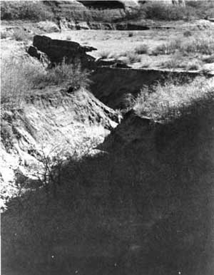
Other threats to the monument were perennial problems. Of these, grazing-induced erosion was the most imminent. Serious concern about the impact of erosion dated from the early 1930s. In 1934, Frank A. Kittredge, the chief engineer of the National Park Service, noted that the small depression in front of Keet Seel had become a seventy-foot-deep gash that obliterated an earlier wagon road. Overgrazing was clearly a contributing cause, but as lands that were both sparsely grazed and heavily grazed showed the characteristic channel-cut features of southwestern erosion, it was hard to blame livestock alone. [22]
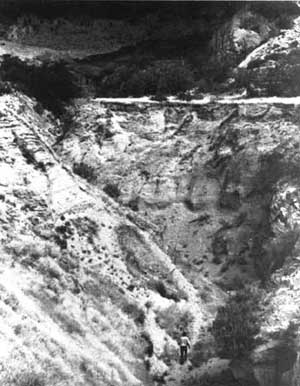
Following the 1930s, erosion remained a major threat to the resources of the monument. Efforts to retard or reverse erosion, such as check dams, failed, and gullying became a constant problem. Betatakin was the least affected of the three major ruins, while Inscription House suffered the most damage. By the 1940s, it was nearly impossible to reach as its wash grew wider and wider. By the 1970s, the gully had become a threat to the approach to the ruins.
|
| Erosion in front of Keet Seel, 1934. |
|
| Arroyo below Keet Seel, 1976. |
The response to erosion typified the dilemma that the Park Service faced at Navajo. It had no control over activities that occurred outside park boundaries and could do little to prevent practices that might be detrimental to the future of the park. The best option that the Park Service had was to fence the three sections of the monument. While this prevented grazing within the monument, it did little to protect its resources from the consequences of actions that occurred beyond its boundaries.
Park officials recognized that there was little they could do to protect the monument from the threat of erosion. Conditions outside of park boundaries spread easily into protected lands, highlighting how much the monument was a part of its surroundings and how little impact the agency had beyond the boundaries of the monument. While the symbiotic relationship between some Navajos and the monument was good for the area, people without direct contact with the NPS felt little cause to change age-old practices to accommodate newcomers. For the Park Service, being dependent on the surrounding region was an unfamiliar circumstance. While cooperation was easy to achieve, inspiring sensitivity to the values the Park Service sought to promote could be more difficult.
Other natural resource management issues faced the monument. Although in essence, the monument was a biogeographic island, too small to sustain diversity without similar programs of management on surrounding land, there were unique natural features of the monument that merited saving. Two among the threatened species, Navajo Sedge (Carex Specuicola), a plant growing in the cracks of the canyon walls, and the Mexican subspecies of the Spotted Owl (Strix Occidentalis Lucida) were the subject of programs. In both cases, the research to support the program came from interested people outside the agency, suggesting a pattern of reaction in natural resource management at Navajo.
The interests and objectives of the Navajo Nation could also pose a threat to the values the NPS sought to protect. The prospect of a dam at the mouth of Tsegi Canyon with a permanent pool of 4,500 surface acres that would back into the Tsegi Tribal Park provided one example. The consequences of a human-made lake surrounding Betatakin and Keet Seel were vast. The increase in humidity from evaporation had the potential to accelerate the disintegration of surface ruins. Even informal discussion of such a proposal merited Park Service attention. [23]
But perhaps the greatest threat to the monument in the late 1980s and early 1990s was the lack of funding available for park programs. Higher visitation totals assured greater exposure in the 1980s, and the number of people who came up the approach road continued to grow. For Navajo National Monument, popularity had always been a mixed blessing. Visitors meant attention and support, but they also intruded on a delicate physical and archeological environment. In the fragile Tsegi area, even footsteps left a persistent imprint.
The pattern of underfunding was not new. Until MISSION 66, Navajo National Monument had largely been ignored by the Park Service. In the 1970s, when Frank Hastings arrived as superintendent, he found the perennial dilemma of funding to be his first and primary concern. Increases in visitation made funding for seasonals insufficient even before it was received, and during his tenure, the park received a steady but slow increase in outlay for ruins maintenance. Yet Hastings recalled, "it took a concentrated effort by the division chiefs and myself to increase funding to a reasonable level." [24]
During the 1980s, little occurred to alleviate the strain on the budget. Superintendents Miller and Gorman found themselves facing increasing demand for services with relatively constant staff and funding levels. New programs were nearly impossible to initiate for a lack of resources, and in some cases, existing programs were scrutinized to see if there was any room for further cuts. Over time, this eroded morale and made the park staff feel increasingly beleaguered.
The realities of the 1990s suggested that the situation would worsen significantly before it got better. In the aftermath of the savings and loan scandals and with a federal budget deficit approaching $300 billion, nearly every federal agency expected to be asked to do more with less. Navajo National Monument faced a more difficult reality than many park areas. Never developed with the emphasis on comprehensive visitor service characteristic of the major national parks and monuments, Navajo lacked a self-contained, self-supporting infrastructure capable of weathering an extended era of limited funding. It was as dependent on the Navajo reservation that surrounded it as was the reverse, and its position remained as precarious as it had ever been. Growing interest in Indians and cultural resources meant that the stream of visitors would continue to increase at precisely the time that the ability to serve them remained constant or in the most extreme of circumstances, decreased.
Growth compelled new arrangements, particularly with area Navajo people. Protection of three unconnected areas in a time of increasing traffic meant either greater vigilance or more complex arrangements with local landholders. The Memorandum of Agreement had been an interim step that over time had become a permanent agreement. It formalized a relationship appropriate for the 1960s, but at the dawn of the 1990s, NPS officials expected that it would require revision. Local Navajos were an important influence on the monument. Closer working arrangements could provide one answer to some of the problems of the monument.
At the dawn of the 1990s, Navajo National Monument faced a difficult situation likely to become more so. Individually, the threats to the park were not considered grave, but cumulatively they represented an obstacle to the fulfillment of the paradoxical preservation/use mandate of the Park Service. Park managers faced the problem of balancing greater demands and pressures with relatively constant levels of resources in an environment in which the Park Service lacked control of its destiny. By 1990, Navajo National Monument had become an island under stress.
The historic situation of the monument had changed. It was no longer isolated, protected by its remote nature and a difficult approach. The problems of Navajo National Monument were those of the rest of the park system, but the small size of the monument and its comparatively low visitation totals limited the support it received from agency coffers. Management of the monument was complicated by the logistical realities of the administration of three unconnected areas. The monument had nearly three times the protection needs of similar areas, but a similar level of resources for such duties. At Navajo, the Park Service was spread more thinly than at other similar areas.
This set of issues loomed large. In the 1990s, Navajo National Monument would continue to become more accessible. The leadership of the Park Service recognized that it could not rely on the remote nature of the park to protect it from depredation. As the number of visitors in the Southwest grows, visitors to the monument will also increase. Managing the impact of those people and the growth of extractive and industrial development on the reservation will play a major role in the future of the monument.
| <<< Previous | <<< Contents >>> | Next >>> |
nava/adhi/chap8.htm
Last Updated: 28-Aug-2006