|
Navajo National Monument Arizona |
|
 NPS photo | |
Canyon Farmers
Centuries ago people farmed the plateaus and bottom lands of these canyons. They built distinctive villages under natural shelters in the cliff walls and successfully met the demands of a rugged environment. For these people periodic migrations were a way of life.
Today nearby Hopi people are among the descendants of these people, with strong ties to the ancient stone villages at Navajo National Monument. These villages are believed to have been stops along the sacred migration paths of at least eight Hopi clans. Tribal elders annually visit these villages and other sacred shrines in the area. They have also identified paintings on canyon walls as clan symbols. The National Park Service preserves these cultural treasures as part of Navajo National Monument.
The two largest villages are best known by the names given to them by the Navajo people who arrived in the vicinity during the 1800s. In Navajo, Betatakin means "ledge house," and Keet Seel is from an altered Navajo word meaning "broken pottery scattered around." The villages are also known by their Hopi names, Talastima and Kawestima. The people who lived here long ago are called Hisatsinom by the Hopi and Anasazi by the Navajo. Anasazi, which means "ancient one" or "ancestors of the aliens," is not a precise term; it groups many different peoples under the same name, and some find the term offensive. Modern descendants of these people prefer the term "Ancestral Puebloans."
Ancient cultures varied throughout the Southwest. The cultural subgroup that came to live in the vicinity of Navajo National Monument is known as Kayenta. Here, among the Kayenta people, pottery styles became vivid and multicolored. Their buildings were more randomly grouped than those elsewhere. The people living here were not always farmers. In earlier times they hunted small game, gathered wild plants, seeds, and berries, and migrated with the seasons. Eventually, traders brought seeds of corn and other food crops into the region from Mexico. The Ancestral Puebloans' slowly developing agriculture practices allowed them to remain in one place.
As they became settled farmers they replaced their temporary brush shelters. At first they lived in pithouses—circular, below-ground dwellings common throughout the Southwest. Gradually they moved into above-ground houses. These were separate family dwellings usually built of stone but sometimes of sticks covered with mud—a construction method today called "jacal." To store each year's harvest surplus, often in pottery vessels, Ancestral Puebloans built storage chambers.
By 1200 the land surrounding today's Navajo National Monument was dotted with the farms of the Ancestral Puebloan people. Their villages, built as clusters of masonry rooms, stood nearby. The people traded far and wide for items like cotton, turquoise, sea shells, and parrot feathers. Through their ceremonies they sought balance and harmony with the natural and spiritual worlds. Rainfall was as scarce then as now, but usually there was enough to sustain their drought-adapted crops. Even so, harder times prompted the people to repeatedly move their farms and villages. While many communities probably remained in the bottomlands, others took shelter in the cliffs. Among these, Keet Seel and Betatakin flourished for five decades. But ultimately, the people withdrew from their homeland. This may have been caused by many factors working independently or together: drought, erosion, social pressures, religious dictates, or other influences not in the archeological record. The villagers joined other peoples in the Southwest in regional migrations, and from this period of change emerged the contemporary Pueblo people.
Cultures of Navajo National Monument
Ancestors of the Hopi (Hisatsinom) lived here for thousands of years. Trade brought corn seeds and other crops into the region. Hisatsinom lifeways changed from nomadic hunting and gathering to farming. They built multi-storied stone masonry houses clustered in villages in Tsegi and Nitsin canyons.
These ancestral lands remain very important to the Hopi. Fire, Flute, and Bighorn Sheep clans inhabited Keet Seel. Betatakin was home to the Deer, Fire, Flute, and Water clans. Inscription House is a Rattlesnake, Sand, and Lizard clan village. These places are active spiritual and physical links between past, present, and future.
You are standing on Navajo Nation land. The boundaries of the Navajo (Diné) homeland are four sacred mountains: Blanca Peak (Sis Naajinii), Mount Taylor (Tsoo Dzil), the San Francisco Peaks (Dook'o'oosliid), and the La Plata Mountains (Dibe Ntasaa).
The Diné changed from hunting and gathering when the Spanish introduced domesticated animals. Sheepherding became central to their lives. The Diné have a long tradition of using the area around Navajo National Monument for sacred and economic purposes.
The San Juan Southern Paiute feel a strong connection to these canyons. They lived in Tsegi Canyon and near Inscription House, hunting, gathering, and raising crops. They lived in this area for many hundreds of years, neighbors to the Hopi and Navajo tribes. Their largest communities are at Hidden Springs, near Tuba City, and at Navajo Mountain. The San Juan Southern Paiute are skilled basket-makers.
The Zuni have lived in the southwest for thousands of years; home is now in New Mexico. They consider the Tsegi Canyon region an essential part of their traditions. It is known as the "northern canyons," from which several of their clans originated. The Zuni traveled through this area on their way to Grand Canyon to mine salt. Betatakin is celebrated in Zuni songs, traditions, and lives.
Ancient Artists
The prehistoric Pueblo people had a successful social order and crafted products we admire today. Geometric designs of grace and balance decorated their vessels, and the patterns in their finely-woven fabrics grew from the same aesthetic principles.
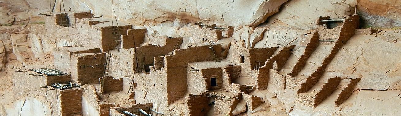
Betatakin
Though agricultural fields lay a mile down-canyon, settlers were attracted to this alcove: It was deep enough for shelter and, because it faced south, was warmed by the winter sun and cool in summer shade. The inhabitants lived here only a short time between 1250 and 1300.
Keet Seel
Keet Seel was occupied much longer than Betatakin. Tree-ring dating and pottery found below the dwelling show that some people settled here by the year 950. Those early houses are completely gone, but a few timbers and some stones were reused in building a second village.
In 1272 building activity surged at Keet Seel and new pottery styles emerged. The population may have approached 150 before the settlement went into decline and families began to leave. Families who remained converted the abandoned rooms into granaries, apparently storing food against hard times. About 1300, these last residents also departed, but not before sealing the doorways of many rooms containing pottery jars of corn. Perhaps they planned to return someday.
The Hopi
It was the Hisatsinom, ancestors of the Hopi, who built the architectural wonders that we know today as Betatakin, Keet Seel, and Inscription House. Each was the village of a distinct clan. They are the ancestral homes of Hopi clans today.
One can envision men, women, and children working together to build their homes in the large alcoves, high above the canyon floor—shaping the soft sandstone, making adobe bricks, and collecting water in pottery vessels to make mortar for bonding the adobe bricks and sandstone. It took great effort to haul building materials up to the alcoves, using only hand/toe holes carved into the cliff face. At the same time they had to tend their fields, hunt, and make pottery, arrow points, and clothing.
With all of these activities, these resilient people also made time for ceremonies as evidenced by their kivas. Here various clans developed ceremonies they would take to the Hopi mesas when they left. Prayers and offerings remain important to Pueblo people today. Ceremonies for rain—so that crops can mature for harvest—and prayers are central to Pueblo lives and are communal. Hopi elders still make pilgrimages to these ancestral villages.
The Navajo
The Navajo emigrated to the Southwest from northern Canada in the late 1500s or earlier. They lived alongside the more settled Pueblo Indian farmers in a relationship characterized by times of peace and trading and times of raiding and counterraiding. Upon acquiring the horse and sheep from the Spanish they became a powerful nation.
As their power grew so did conflicts with their Hopi and Pueblo neighbors. To end the conflict, the U.S. Army in 1863-64 invaded the Navajo homeland, killing people and destroying homes, crops, and livestock. Much of the tribe was taken captive and marched nearly 300 miles to a reserve near Fort Sumner, N. Mex. Under a treaty four years later, the Navajo were allowed to return to their own land with enough sheep to start anew. The "Long Walk," however, remains a tragic ordeal in Navajo memory.
Today there are over 300,000 Navajos living on or near reservations. New ways enrich their traditions as the Navajo continue to adapt to the changing world.
Visiting the Monument
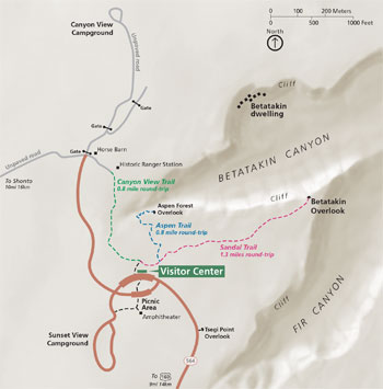 (click for larger map) |
To reach the monument, follow U.S. 160 50 miles northeast of Tuba City or 20 miles southwest of Kayenta. A 9-mile paved road, Ariz. 564, takes you from U.S. 160 to the monument. There are exhibits and films, and books on sale at the visitor center. Navajo Arts and Crafts Enterprise has a gift shop specializing in Navajo silverwork. The visitor center and restrooms are accessible to visitors with limited mobility.
Campground and General Information
Two campgrounds and a picnic area are available first-come, first-served. Group camping sites are also available. The campgrounds have charcoal grills, but wood fires are not allowed. The nearest food and fuel are at Black Mesa Trading Post at the junction of Ariz. 664 and U.S. 160. Pets must be leashed at all times. They are not allowed in buildings or on trails.
Mesa Top Trails
Sandal Trail This paved trail leads to an overlook with a spectacular cross-canyon view of the ancient village of Betatakin (one mile round-trip).
Aspen Forest Overlook Trail This trail branches off the Sandal Trail and descends steeply 300 feet to view an ancient forest of aspen (0.8 mile round-trip).
Canyon View Trail This trail leads to a view into Betatakin Canyon and Canyon View campground (0.6 mile roundtrip).
Free Guided Hikes
Betatakin Tours are ranger-guided. This strenuous, round-trip hike takes 3 to 5 hours. The elevation is 7,300 feet, and the climb out of the canyon is 700 feet. Wear sturdy shoes and carry two liters of water. If you have heart or respiratory problems, do not attempt this hike.
Keet Seel Hikers must acquire a backcountry permit from the visitor center. Daily limit is 20 people for this 17-mile roundtrip hike on a primitive trail. Elevation loss and regain is 1,000 feet.
These cliff dwellings are a fragile part of our national heritage. Please help us preserve them by not disturbing them, removing anything, or entering them without a ranger.
For Your Safety
This is a natural area with canyons, cliffs, falling rocks, flash-floods, lightning, and other hazards. Be alert and safety conscious at all times. Rocks can fall at anytime in the alcoves and canyons. Visitors on tours enter the alcoves at their own risk.
Related Sites
Ancestral Pueblo cultures developed in three important centers: Kayenta (represented by this monument). Mesa Verde (at Mesa Verde National Park), and Chaco (at Chaco Culture National Historical Park). Other parks associated with Pueblo cultures, include Canyon de Chelly, Aztec, and Wupatki.
Source: NPS Brochure (2008)
|
Establishment Navajo National Monument — March 20, 1909 |
For More Information Please Visit The  OFFICIAL NPS WEBSITE |
Documents
Archeological Assessment: Navajo National Monument Southwest Cultural Resources Center Professional Papers No. 9 (J. Richard Ambler, June 15, 1985)
Archaeological Investigations in Turkey Cave (NA2520), Navajo National Monument, 1963 Museum of Northern Arizona Technical Series No. 8 (David A. Breternitz w/Hugh C. Cutler, 1969, ©Museum of Northern Arizona, Archives, all rights reserved)
Arizona Explorer Junior Ranger (Date Unknown; for reference purposes only)
Biological-Ecological Aspects of Betatakin Canyon, Navajo National Monument (Angus M. Woodbury, June 1963)
Draft General Management Plan / Environmental Impact Statement, Navajo National Monument, Arizona (c2003)
Ecological Studies at Navajo National Monument, Part I (Jack D. Brotherson and John Fairchild, November 6, 1977)
Ecological Studies at Navajo National Monument, Part II (Jack D. Brotherson, Samuel R. Rushforth, William E. Evenson, Lee Anne Szyska, John Fairchild, Jeffrey R. Johansen and Clifford Morden, June 28, 1980)
Ecological Studies at Navajo National Monument, Part III (Jack D. Brotherson, Samuel R. Rushforth, Jeffery J. Johansen, Larry L. St. Clair and Glen T. Nebeker, November 1, 1981)
Final General Management Plan / Environmental Impact Statement, Navajo National Monument, Arizona (2003)
Foundation Document, Navajo National Monument, Arizona (August 2017)
Foundation Document Overview, Navajo National Monument, Arizona (January 2017)
General Management Plan Summary, Navajo National Monument, Arizona (2003)
Geologic Resource Evaluation Report, Navajo National Monument NPS Natural Resource Report NPS/NRPC/GRD/NRR-2007/005 (J. Graham, June 2007)
Influence of cryptogamic crusts on moisture relationships of soils in Navajo National Monument (Jack D. Brotherson and Samuel R. Rushforth, extract from Great Basin Naturalist, Vol. 43 No. 1, January 1983)
Inventory of Amphibians and Reptiles at Navajo National Monument (David Mikesic, May 3, 2004)
Junior Arizona Archeologist (2016; for reference purposes only)
Junior Ranger Activity Booklet, Navajo National Monument (Date Unknown; for reference purposes only)
Mammal Inventory for Navajo National Monument NPS Natural Resource Technical Report NPS/SCPN/NRTR-2010/377 (Shauna Haymond and Richard E. Sherwin, September 2010)
National Register of Historic Places Nomination Form
Navajo National Monument (J. Richar Ambler, January 8, 1988)
Navajo Geological Report Southwestern Monuments Special Report No. 8 (Vincent W. Vandiver, 1936)
Navajo National Monument: A Place and Its People, An Administrative History (HTML edition) Southwest Cultural Resources Center Professional Papers No. 40 (Hal K. Rothman, 1991)
Park Newspaper (InterPARK Messenger): c1990s • 1992
Preliminary Report on a Visit to the Navaho National Monument, Arizona (HTML edition) Bureau of American Ethnology Bulletin 50 (Jesse Walter Fewkes, 1911)
Report on Sullys Hill Park, Casa Grande Ruin; the Muir Woods, Petrified Forest, and Other National Monuments, Including List of Bird Reserves: 1915 (HTML edition) (Secretary of the Interior, 1914)
Report on Wind Cave National Park, Sullys Hill Park, Casa Grande Ruin, Muir Woods, Petrified Forest, and Other National Monuments, Including List of Bird Reserves: 1913 (HTML edition) (Secretary of the Interior, 1914)
Rock-Fall Hazard Assessment of the Aspen Forest Trail, Navajo National Monument, Arizona USGS Open-File Report 2000-305 (Gerald F. Wieczorek and Edwin L. Harp, 2000)
Snake House Ruin 1978: Stabilization of Snake House Ruin, Room 3 (Susan L. Breternitz Goulding, May 1979)
The Excavation and Repair of Betatakin, Navajo National Monument (Neil Merton Judd, 1930)
The Navajo Country — A Geographic and Hydrographic Reconnaissance of Parts of Arizona, New Mexico and Utah USGS Water Supply Paper 380 (Herbert E. Gregory, 1916)
Traditional History Study of Navajo National Monument: An Ethnographic Literature Review of Publications on Hope, Zuni, and Navajo (Marilyn Norcini, Louis A. Hieb and Nigel Holman, September 2001)
Vegetation Classification and Distribution Mapping Report: Navajo National Monument NPS Natural Resource Technical Report NPS/SCPN/NRTR—2010/298 (David Salas, Dave Wegner and Cory Bolen, March 2010)
Water-Quality Data for Navajo National Monument, Northeastern Arizona--2001-02 USGS Open-File Report 2003-287 (Blakemore E. Thomas, 2003)
nava/index.htm
Last Updated: 01-Jan-2025