|
North Cascades
An Ethnographic Overview and Assessment of North Cascades National Park Service Complex |

|
2.0 A REVIEW OF THE ETHNOGRAPHIC AND ETHNOHISTORIC DATA BASE
The North Cascades National Park Service Complex consists of 671,096 acres distributed throughout four contiguous units lying within Whatcom, Skagit and Chelan Counties in Washington State. North Cascades was the third national park established in the State of Washington, preceded by Olympic and Mount Rainier. Two of the units make up the North Cascades National Park which is separated by the third unit, Ross Lake National Recreation Area. The fourth unit is Lake Chelan National Recreation Area which lies below the southern portion of the national park. These four units are managed collectively as the North Cascades National Park Service Complex (NOCA) (see Figure 1). The following description is from Mierendorf (1986:1).
The North Cascades straddle the northern reaches of the Cascade Mountain range which extends from the Fraser River in British Columbia to below the Oregon border. The complex is characterized by high peaks, alpine meadows, glacial lakes and forested valleys and hillsides. The entire complex is traversed by only one road, the North Cascades Highway, which follows the Skagit River Valley. North Cascades National Park Service Complex was established by law in 1968 to preserve natural wilderness of the national park units and to provide recreational opportunities to the public at the Ross Lake and Lake Chelan National Recreation areas.

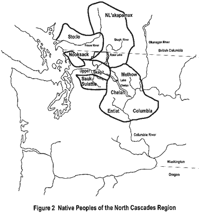
NOCA lies between two distinct Native American cultural areas, the Plateau and the Northwest Coast. It encompasses territory claimed by a number of Native American groups of the Coastal and Interior Salish. By contemporary designations these groups include the Nooksack, Sto:lo, Sauk-Suiattle, Upper Skagit, Chelan, Methow, Entiat, Wenatchi and NLakapamux (formerly known as the Thompson). These park-associated groups speak languages of one of two major divisions of the Salish language family, Coast Salish and Interior Salish. The map entitled Native People of NOCA (Figure 2) shows the general territory of these groups as described by Spier (1936) and Suttles (1985) and as based on the standard ethnographies. Ethnographies exist for many of these groups and from this information some general statements can be made concerning tribal territories within NOCA. These territories cannot, however, be viewed as hard and fast boundaries. Expansion and contraction, the creation of political boundaries, the establishment of reservations, land claims and resource rights have all affected the manner in which tribal territories were claimed in the past and in which they are claimed today.
2.1 Tribal Territories
The ethnographic data describes tribal territories as follows.
For the Upper Skagit Collins (1974:5) writes.
The western boundaries of these people were formed by the two-mile-long log jam west of Mount Vernon, the eastern by the Cascade Mountain divide, and the north by the ridges which separated them from the valley of the Nooksack River and the territory of the Thompson Indians who hunted along the Skagit headwaters in Canada. One northern headwater of the Skagit River came near their territories. To the south the ridges dividing the Stillaguamish River from the Skagit formed a boundary; this boundary was broken by the Sauk, a long, important tributary of the Skagit which flows into the main river from the southwest and comes very near the Stillaguamish.
This differs slightly from Smith (1988:6-8) who follows the Upper Skagit territory as defined in the tribe's petition to the Indian Claims Commission. Ethnographers tend to include the Sauk-Suiattle with the Upper Skagit but since they are a separate tribal entity today and were identified separately in the Treaty of Point Elliott, I will discuss their territory in the vicinity of NOCA as distinct from that of the Upper Skagit.
There is no ethnography of the Sauk-Suiattle. Boxberger (1994:569) gives a cursory description of their territory as including the Sauk and Suiattle Rivers watersheds from the confluence of the Sauk and Skagit Rivers to the crest of the Cascade Mountains. This description is based on ethnohistoric research into Sauk-Suiattle homesteads in the Suiattle River valley (Boxberger 1987). Martin Sampson (1972) makes even finer distinctions between the various groups of the Skagit River valley based on his identification with the named groups in the Treaty of Point Elliott. Sampson separates the Sauk-Suiattle from the Upper Skagit groups as well. Neither Upper Skagit nor Sauk Suiattle are identified by their current designations in the Treaty of Point Elliott. Sampson (1972:24) associates Noo-qua cha-mish, Me-sek-wi-guilse, Sba-le-och and Mis-skai-whwa with the Upper Skagit and Sah-ku-meh-hu with the Sauk-Suiattle.
The Nooksack lived in villages along the Nooksack River watershed from Ferndale to the mouth of Kendall Creek but their traditional use areas extended to the western slopes of the Cascade Mountains from Twin Sisters northward to the Canadian border (Richardson 1974). Smith (1988) does not include the Nooksack in his report Ethnography of the North Cascades but ethnographic and ethnohistoric evidence exist to suggest the Nooksack used lands within NOCA borders. Richardson's map (1974), Fetzer's testimony in the Nooksack Indian Claims Commission petition and the mountaineer Coleman (1869), who used Nooksack guides in the Mount Baker area, all provide sufficient evidence to include the Nooksack in this study. While none of these works give specific boundaries to the Nooksack territory, we can infer from statements they contain that the Nooksack traditional use areas extended into NOCA.
The Sto:lo, in particular the Chilliwack band, defined their territory as extending below the Canadian border into NOCA along the Chilliwack River valley (Duff 1952:20-21). From there trails brought them to the Skagit and Nooksack River valleys (Wells 1966). The boundary commission survey of the United States- Canadian border in 1859 relied on Sto:lo guides to assist them in traversing the North Cascades. These guides had detailed knowledge of the North Cascades area which suggests extensive use. The work of the boundary commission is discussed below.
The NLakapamux (formerly known as the Thompson, specifically for this study, the Lower Thompson) are described by Teit (1900:168) as hunting and gathering in the areas of the headwaters of the Skagit and Nooksack Rivers. As Smith (1988:148) points out this conflicts with Upper Skagit claims, and, I might add, with Nooksack claims. This, however, should not be seen as a matter of right or wrong interpretations, rather it was likely the result of shifting boundaries and overlapping use areas.
The other Interior Salish groups in proximity to NOCA include the Chelan, Entiat, Methow and Wenatchi. There is some confusion as to whether these four groups compose separate tribes or were bands of one larger tribal group (this is discussed at some length in Smith 1988:251-263). Smith implies that these four groups be considered as separate entities because for the Chelan at least, that is how they view themselves (Smith 1988:259). It is not at all clear from the data presented how that conclusion was derived. In other sources these groups have been lumped together with the Okanogan (Ross 1849:259), the Wenatchi (Teit 1928:89) the Columbia (Suttles 1985), considered by the larger grouping of the Central Interior Salish (Ray 1936) or as separate tribes (Spier 1936). Perhaps these differences are not so much points of confusion as the nature of intergroup relations on the Plateau. As is typical of Salish people different stretches of the Columbia River or different drainage systems of the tributary streams were the "territory" of specific groups. The Wenatchi lived along the Wenatchee River Valley, the Entiat in the Entiat River Valley, the Chelan along the Chelan River and Lake Chelan and the Methow in the Methow River Valley. Linguistically and culturally these groups were similar. Trying to draw distinct boundaries between them is a futile attempt. Intermarriage, interaction for ceremonials, sharing of resource locations and other types of interaction tied these groups together into a network of intergroup relations. Typically on the Plateau ethnographers fall back on the winter village locations to delineate tribal territory. While this approach is useful for distinguishing a land base it is misleading when it presumes territorial use did not extend beyond the lands immediately surrounding the winter village sites. Both Ray (1936) and Smith (1988) are guilty of this assumption. I suggest that we view the tribal territory as just one type of use and take into account the broader patterns of land and resource use. The Salish people traveled widely for various purposes including trade, hunting, fishing, and ceremonial gatherings. The lands they utilized overlapped with their neighbors, who, for some purposes were not their neighbors but part of the same group. Interactions of this sort were the rule rather than the exception. If these four tribes are considered as distinct then it presents one set of circumstances, if lumped together, quite another.
The Wenatchi and Entiat were both signatory to the Yakama Treaty of 1855. The river systems where they lived are part of the ceded lands. The Chelan and Methow were expected to remove to the Colville Reservation, which was not established by treaty. Recently the Colville Tribe unsuccessfully attempted to assert treaty fishing rights by claiming descendence from signatories to the Yakama Treaty. It is clear that members of all four of these groups belong to the Colville Tribe and at least some of them to the Yakama Tribe. Therefore it leads us to the conclusion that both the Confederated Tribes of the Colville Reservation and the Confederated Tribes and Bands of the Yakama Reservation are both heirs of succession to the Wenatchi, Entiat, Chelan and Methow. If all the groups are subsumed under the "Wenatchi" designation, as Teit suggests, then this would place them within the named groups of the Yakama Treaty. The Colville Tribes claim descendence from the Chelan, Methow, Entiat and Wenatchi groups among others (Walker 1994:132; see also findings of fact in United States v. Oregon v. Colville, 115 S. Ct. 2246 [19951). In actuality members of all four groups have become part of the Colville and Yakama Tribes.
Based on my review of the ethnographic data these groups clearly have cultural affiliations with NOCA. While the ethnographic data is sketchy we can reasonably infer that these groups' territories extended into NOCA and/or they relied in part on resources located within the North Cascades area. The ethnographic data are inconsistent for a variety of reasons not least of which is the different purposes for which the data were collected.
2.2 The Ethnographic Data to About 1950
I have identified chronologically and topically three types of ethnographic description for the tribes of the NOCA area. These consist of the early ethnography to about 1950, the Indian Claims Commission research, and the more recent project stimulated research. Each of these will be reviewed for the purpose of evaluating their usefulness in meeting the needs of NOCA managers for decisions 'concerning park associated populations and cultural and natural resource uses of the park.
The earliest ethnographic description of NOCA associated populations actually begins with the first professional ethnographer in North America. In the 1890s Franz Boas, often referred to as the "Father of American Anthropology," conducted field research among the Sto:lo and other Fraser River bands on behalf of the British Association for the Advancement of Science (Boas 1894). During this trip Boas met James Teit, a Shetland born trader who was married to a NLakapamux woman and spoke the language fluently (Boas 1922:490). Boas gave Teit minimal instruction in ethnographic field methods and commissioned Teit to collect ethnographic data on the NLakapamux and other Interior Salish groups (see Sprague 1991 for a complete bibliography of Teit's contributions to North American ethnography). The work of Boas influenced most early ethnography of native North Americans and Teit was certainly no exception. The style of Boas and his generation of ethnographers has been termed "historical particularism." By this is meant the attempt to describe cultures in detail without attempting to interpret or theorize about causation. For Boas each culture was a unique product of its own history. Trained primarily in museum anthropology and as a natural scientist, Boas had a decided interest in material culture and ceremonial life, coupled with his holistic approach to describing culture we find his ethnography is often more about what people do rather than where they do it. While identifying tribal areas was often a concern of Boas's it usually did not go beyond a general description of their territories. Information about resources and site-specific uses is absent. For Boas the goal was to try and recapture what Native cultures were like before European contact. This meant selectively choosing data that was not a result of contact and often ignoring important information that was indicative of the present time. So even though Boas's approach was "historical it was not history as we mean it today. Rather it was a type of natural history of the tribes that was focused on information gathered from them and not from external sources.
Teit's work on the NLakapamux (1898; 1900; 1912; 1917; 1930) and on the Columbia Salish (1928; 1930) are particularly rich sources but are very much in the Boasian mode. In the historical particularist tradition the works are organized around broad cultural categories such as "manufacture," "house and household," and "subsistence". Overall there is a heavy focus on material culture and mythology, both primary interests of Boas. Where mention is made of specific areas it is usually village sites (e.g. Teit 1900:169). Nevertheless, because Teit describes the territories of the NLakapamux and Wenatchi his descriptions bear repeating here.
For the NLakapamux,
Their habitat is the southern interior of British Columbia, mostly east of the Coast Range, but it extends far into the heart of that range. . . . It is about a hundred miles in length, by ninety in breadth. Through this territory flow three rivers, -- Fraser River; its principal tributary, Thompson River; and a smaller tributary of the latter, Nicola River. In the valleys of these rivers, or in close proximity thereto, are found the principal villages of the tribe, while the country on either side is their hunting ground. (Teit 1900:167)
For the Wenatchi,
The Wenatchi (or .s.npeskwau'zux) occupied the Columbia valley immediately above the Columbia Salish, north to about half way between the mouths of the Methow and Okanagon Rivers, and embracing all of the country on the west side of the Columbia to the Cascades and a little beyond in some places, from the boundaries of the Thompson tribe in the north, to the Yakima in the south. (Teit 1928:93)
While the territories are broadly delineated and village locations identified, other site-specific information is lacking. The use of NOCA areas can be inferred from general statements such as "the Lower Thompsons found stone for their arrow-heads near the head waters of the Skagit River" (Teit 1900:241) and "they even hunted on the mountains on the western slope of the Coast [Cascade] Range" (1900:239). Other uses of NOCA probably included plant gathering (Teit 1900:231) spiritual activities (1900:318) and access to other groups via trade routes (1900:258).
Similarly Teit makes general statements about Wenatchi culture (within which he subsumes Chelan and Methow (1928:95)). Most of the work The Middle Columbia Salish concerns Teit's theories about the interaction between Salish and Sahaptin speakers on the Plateau and the supposed migrations of these groups to their historical locations. These ideas are not generally accepted today (see Hunn 1990:66-67), nevertheless Teit's depiction of Wenatchi territory agrees with that of later ethnographers as discussed below. Similar to his work on the Nlakapamux Teit mentions use of mountain areas for trade access by the Wenatchi (1928:121). The work on the Sto:lo by Wilson Duff (1952) although later is still in the Boasian tradition. Duff divides his ethnographic description into the typical cultural categories of subsistence, material culture, religion and so on. Site specific information for the Chilliwack is limited to village locations (Duff 1952:37-39). Reference to areas that possibly fall within NOCA are hunting "in the mountains" (1952:71), picking berries in the mountains in late summer (1952:73) and trade with groups east of the Cascade Mountains (1952:95).
Duff's map shows Chilliwack territory extending into NOCA and overlapping with other group's claimed territories, especially the Nooksack and NLakapamux but site specific information on cultural or natural resource use locations is lacking.
The amateur ethnographer Oliver Wells produced a map of Chilliwack territory (1966). The map includes all of the Chilliwack River drainage. Especially informative is his clear identification of trails from the Chilliwack area to the Skagit Valley in NOCA via Big Beaver Creek (see Figure 6). Wells's (1987) work is primarily transcriptions of interviews with elderly Sto:lo. Mention is again made of trails to the Skagit River and also to the Nooksack.

Other ethnographies from this era exist for the NOCA tribes, notably Hill-Tout on the NLakapamux (1899) and Chilliwack (1902). As Smith (1988:146) points out Hill-Tout's work is full of Victorian-era stereotypes and speculation. Nevertheless Hill-Tout's description of territories compares quite closely with Teit's and Duff's (Hill-Tout 1899:41-43; 1902:41). Marian Wesley Smith, anthropologist from Columbia University published a series of articles in the 1940s that discuss general tribal relations among the Sto:lo and Puget Sound Salish (see e.g., 1941; 1950) that also belong to this era of ethnographic description. Smith notes close ties between the Nooksack, Chilliwack and Skagit but claims that the Nooksack were "cut off from travel across the mountains to the Plateau" (Smith 1950:331).
To summarize, the period of ethnographic reporting in North American anthropology known as historical particularism resulted primarily in descriptive accounts of broad patterns of culture. While useful in their search for patterns and the attempt to gather data that was comparable cross-culturally their use for modern-day management in the National Park system is limited. As discussed above these works primarily focus on the "traditional" culture often at the expense of culling out reference to important cultural features of the time. While these works are important they only form part of the data base. The processes of culture change, post-reservation history and contemporary use patterns (at the time of the study) are lacking. Therefore these lacunae must be filled with supplementary data, some of which is discussed below but much of which does not presently exist. Primarily we can look to this ethnographic tradition as providing us with an attempt to recreate traditional culture and to identify tribal use areas. However, these works have to be used with some discretion and inevitably must be supplemented with later ethnographic work and ethnohistorical sources.
2.3 The Ethnographic Data to About 1980
As early as the 1930s dissatisfaction with the Boasian approach was becoming apparent. This was first evident in the "Culture Element Distribution" studies emanating from the University of California. These studies were designed to gather specific cultural traits in list form for easy cross-cultural comparison. This was essentially similar to the Boasian approach but without the narrative description. Culture element distribution lists exist for the Plateau as a whole (Ray 1942) for the Northwest Coast as a whole (Drucker 1950) and for the Coast Salish (Barnett 1939). While the culture element distribution lists are useful for comparing specific traits (e.g. see Jorgensen 1969) their utility is limited for site-specific research.
The second era of ethnographic description was ushered in with the passage of the Indian Claims Commission Act of 1946 [60 Stat. 1040]. This act established a court of claims to enable Native American tribes to bring grievances before the court concerning unfulfilled treaty promises, inadequate compensation for lost land and resources, and other specific claims. In order to provide the evidence necessary to adjudicate Native claims both the tribes and the federal government employed anthropologists to provide expert testimony concerning traditional culture, resource use and historic changes. The following individuals prepared reports concerning groups in the NOCA area: Paul Fetzer, Nooksack, Docket No. 46; June McCormick Collins, Upper Skagit, Docket No. 92; Verne Ray, Columbia, Chelan, Entiat and Wenatchi, Docket No. 161 and Colville, Docket No. 181.
Due to the nature of the claims commission hearings ethnographers were forced to reevaluate their focus on traditional culture and incorporate analyses of post-contact culture history. The role of anthropologists in the Indian Claims Commission process was what spawned the new approach in anthropology known as ethnohistory. Initially ethnohistory focused on Native American culture change as determined from the analysis of historic documents in conjunction with traditional ethnographic methods of informant interviews and observation. Since the Indian Claims Commission was concerned with aboriginal territories of tribes considerable attention was given to that aspect of the ethnographic reports and testimony at trial. Since the NLakapamux and Sto:lo are Canadian bands they were not party to the Indian Claims Commission process. Four cases were filed by groups associated with NOCA. Each of these will be discussed in reference to the materials relevant to land and resource use in the NOCA area.
Paul Fetzer started research among the Nooksack in the late 1940s as part of his doctoral research in anthropology at the University of Washington. He was unfortunately killed in an automobile accident before he could complete his study (Amoss 1978:xiii). Prior to his death Fetzer prepared testimony for the Indian Claims Commission in 1950 and 1951 specific to the Nooksack territorial claims. The eastern extent of Nooksack territory was identified as extending "past Mount Baker" and also included testimony that the Nooksack would go into the mountain areas to pick berries and hunt mountain goat (1950:20).
For the Skagit Collins presented information she had collected while doing field work among the Upper Skagit in the 1940s. The report was later reworked and published as Valley of the Spirits: The Upper Skagit Indians of Western Washington (1974). Collins identifies several uses of the NOCA area but again specificity is lacking. She claims the Skagit hunted for mountain goat (1974:52), gathered high mountain berries (1974:56- 57), used the mountain areas for spiritual activities (1974:157) and for trade and travel (1974:66,80,85,112). For Collins the Sauk-Suiattle are part of the Upper Skagit but because they are a separate tribal entity today they are considered distinct tribes for the purpose of this assessment and evaluation. The Sauk Suiattle filed a separate claim (Docket 97) with the Indian Claims Commission but were denied a separate hearing and combined with the Upper Skagit case.
For the Confederated Tribes of the Colville Reservation different claims were filed by some of the tribes consolidated onto the Colville Reservation. Only those reports relating to the park-associated tribes are reviewed here. Of primary concern here is the report prepared by Verne F. Ray entitled Ethnohistorical Notes on the Columbia, Chelan, Entiat and Wenatchee Tribes (1957). Ray, also associated with the Culture Element Distribution lists discussed above, had conducted ethnographic field work in the Plateau in the 1930s and 1940s. His works Native Villages and Groupings of the Columbia Basin (1936) and Cultural Relations in the Plateau of Northwestern America (1939) identify tribal territories and village locations. Ray was particularly interested in the network of interaction and the distinctive attributes of Plateau culture. Ray describes a pattern of territoriality that is specific around village sites but becomes less strictly defined as one extends further outward. Ray suggests that we look upon boundaries more as a "conceptual thing" not a barrier and that the boundary areas between tribes were more of a common area then an exclusive domain (Ray 1939:16). This work is obviously a product of the Culture Element Distribution approach as Ray carefully compares culture traits between groups throughout the Plateau. It also forms the basis of much of his later work for the Indian Claims Commission process.
Ray's work on the Columbia, Chelan, Entiat and Wenatchi is primarily a compilation of ethnohistorical data. It is brief in comparison to other Indian Claims Commission reports possibly reflecting a dearth of information or because Ray also prepared a report on behalf of the Confederated Tribes of the Colville Reservation. Included in the Columbia, et al. report are a list of village names and a general discussion of Chief Moses and the Columbia Reservation. The Columbia Reservation was in existence from 1879 to 1886 and encompassed an area bounded on the east by the Okanogan River, on the south by the Columbia River and Lake Chelan, on the north by the Canadian border and on the west along a line drawn at 44 degrees west of Washington, D.C. (Washington, D.C. is at 76 degrees 51 minutes longitude, added to 44 this would place the border approximately near the Cascade crest) In 1886 the Columbia Reservation was abolished and the Columbia and Chelan were to relocate to the Colville Reservation although some individual allotments were retained in the southeast area of Lake Chelan.
Another set of reports were prepared by Stuart A. Chalfant on behalf of the United States for testimony in the Indian Claims Commission hearings. A Report on the Anthropological and Ethnohistorical Material Relative to Aboriginal Land Use and Occupancy by the Columbia Salish of Central Washington and A Report on Anthropological and Ethnohistorical Material Relative to Aboriginal Land Use and Occupancy by the Wenatchi Salish of Central Washington are based on many of the same sources as Ray's report. Chalfant identifies some village sites and land use practices, however information specific to NOCA lands is lacking.
Perhaps the most useful bit of information to come out of these reports is the determination that the Entiat and Wenatchi were signatory to the Yakama Treaty but the Columbia and Chelan were not. This aspect of treaty or non-treaty status is discussed below.
2.4 The Ethnographic Data Since About 1980
The third type of ethnography is composed of reports conducted for contract or other specific research. Much of this material was produced as a result of specific needs for ethnographic information or to fulfill government land management needs. Most of this work was produced at the behest of federal agencies although tribal governments have also commissioned specific research.
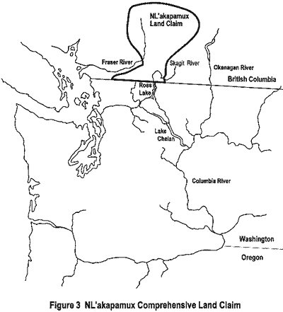
In Canada there have been few projects in the Skagit Valley Recreation Area and Manning Provincial Park, provincial lands immediately adjacent to NOCA, that have examined archaeological and historical questions. Included in this literature are Fraser and Farr (1989); Frontier Book No. 19; and Harris (1982, 1991). These reports tend to be focused on the historic pack trails and mention of Native people are few. Native people, however, are presently commissioning research for Comprehensive Land Claims and the ongoing British Columbia Treaty Negotiations. Comprehensive Land Claims were begun in 1973 when the Canadian government announced that it was ready to negotiate land claims with Native groups where their traditional and continuing interest in the lands concerned could be established. This has necessitated that bands begin gathering ethnographic and ethnohistoric information in much the same manner as United States tribes did for the Indian Claims Commission hearings. At present 110 bands in British Columbia have filed their intention to pursue land claims but thus far very little research has been completed. That research that has been done is being held in confidence until such time as the claims proceedings become public. The NLakapamux claim encompasses the area north of NOCA (see Figure 3). Their claim does not, of course, extend into the United States because their claim is against the Canadian government. The NLakapamux have, however, voiced an interest in their traditional territories in the United States, most notably during the Federal Energy Regulatory Commission relicensing of Seattle City Light's Ross Lake dam. At present the Sto:lo claim has not been established but it will undoubtedly overlap with the southwest portion of the NLakapamux claim.
Other projects have included language, oral history and ethnobotanical studies (Bouchard 1973; Turner, et al. 1980; Laforet 1980; Galloway 1990; Turner, et al. 1990; Albright 1992). The studies of plant procurement are particularly instructive because they often identify areas where plants were and are gathered. None of these reports, however, have thus far been completed for NOCA lands.
For NOCA three ethnographic overviews have been completed. Thompson (1970) is a brief review of mostly secondary sources. It is very incomplete and not of much use in comparison with the latter two. Mierendorf (1986) is primarily an overview of the prehistoric population of NOCA. The objectives of this study were to establish a data base for use in long range planning. The ultimate goal is to inventory all archaeological resources in NOCA and this report reviewed archaeological work that had been completed up until that time and made recommendations for further research. While not technically an ethnographic overview Mierendorf's work does present an overview of the ethnographic data as it relates to archaeological concerns.
Smith (1988) conducted an ethnographic overview of NOCA to achieve three goals. First, to determine the Native American tribes and bands that claimed and made use of the lands within NOCA. Second, to reconstruct an overview of the "traditional" culture of these groups. And third, to ascertain the ways in which the resources of NOCA were utilized by these groups (Smith 1988:1). Smith determined that four groups had legitimate claims to NOCA; the Upper Skagit, within which he subsumed the Sauk Suiattle; the Chilliwack band of the Sto:lo Nation; the Lower Thompson (NLakapamux) and the Chelan. While my report agrees with Smith's conclusions I would extend the claims to other groups too, i.e., the Nooksack, and other bands of the Interior Salish, the Methow, Entiat, and Wenatchi, in addition to the Chelan.
Other project-stimulated research includes historical and oral histories (discussed below) and archaeological reports. Most notable have been the archaeological reports by Mierendorf (1987; 1988; 1989; 1991 and 1993). Mierendorf (1993) is especially important as he has restructured the way in which archaeologists think about prehistoric use of the high mountain areas. Mierendorf (1986:29-44) gives an excellent overview of archaeology preceding his own in and adjacent to NOCA. Both Mierendorf (1986) and Smith (1988) should be read in conjunction with this report.
2.5 The Ethnohistoric Data, Early Explorers
For ethnohistorical research primary source documents often provide a wealth of information. Historians distinguish between primary and secondary sources. Primary sources are those written from direct observation or experience. Explorer's journals, diaries, oral histories and reminiscences are examples of primary sources. Secondary sources refer to syntheses of information derived mostly from primary sources and, perhaps, from other secondary sources. Obviously good ethnohistorical research will depend on primary sources for the basic data base although secondary sources are often useful for the analysis they provide of broad historical patterns and the interpretation they lend to historic periods.
There are two general types of primary sources available for NOCA. The reports of early explorers and fur traders from 1814 to 1887 and the diaries and reminiscences of settlers from 1887 to about 1920. Most secondary sources are more recent and tend to have been produced by amateur historians.
The first written records from first-hand observations of the NOCA are from Alexander Ross who traversed the North Cascades north of Lake Chelan in 1814 (Majors 1980). While at the fur trade post at Fort Okanogan Ross attempted to explore the North Cascades for the purpose of assessing the potential for the fur trade and to find a shorter route to Puget Sound. While there is some disagreement over the exact route Ross followed, it is clear that he reached the Skagit River, probably via Cascade Pass and the Cascade River.
The important information from Ross's journal is the fact that he was guided by local Native people who were familiar with the trails and terrain. This is a commonality with subsequent explorations, that is, that they depended upon Native knowledge to assist them in their "discoveries".
The next attempts did not come until after the establishment of the international boundary at 49 degrees north latitude in 1846. Members of the joint United States - Great Britain Boundary Commission traversed the NOCA area surveying the 49th parallel from 1857 to 1859 (Majors 1984). The easiest routes of access were via the Native trails and the Boundary Commission depended on Native guides. For this study the field notes of the Boundary Commissioners housed at the National Archives in Washington. D.C. were reviewed. In them are descriptions of the Native guides' "mental maps" of the North Cascades. One map includes nearly the entire NOCA area. This gives rich insight into the Native knowledge of the NOCA terrain and how the area was perceived. These maps are discussed in detail below. Of the maps he collected from his Sto:lo guide the Boundary Commissioner Henry Custer said the following.
One of the Indians in my employ (Thiusoloc) a Samona Chief, had the most extended geographical knowledge, of any Indian I ever had to deal with. By request he made me a map of the extend of the country, he was well acquainted with, it was bounded by the Fraser river to the North, the Skagit River to the East, by some tributary of this river to the South and by the Nooksahk and Chilowyuck Rivers to the West. Within these limits his knowledge of the country was most minute and reliable. The map he made of it, although in the most primitive stile, was remarkable for its correctness, and completeness. In this way we gained most of our first knowledge of the country, as also many of the names of its mountains, smaller streams and lakes. (Majors 1984:119; spellings as in the original)
The boundary surveyors found it impossible to directly traverse the 49th parallel and therefore chose to access the border via the north-south running river valleys. The Lake Chelan-Cascade Pass-Skagit River route was explored from the north by Henry Custer, who got as far as the Cascade River, and from the south by George Gibbs. A detailed map produced by Gibbs identifies Native villages, trails and place names in and near NOCA. A copy of a portion of this map is included as Figure 7.

Subsequent explorations (Linsley and Tennant 1870; Klement 1877; Merriam and Symons 1879; Pierce 1882; Rogers 1887) were for the purpose of scouting possible railroad routes through the North Cascades or for mineral exploration. Most of these expeditions employed Native guides; those that did not noted Native use of the area in passing comments. The useful information from these sources that is specific to NOCA has been gleaned by Luxenberg (1986).
2.6 The Ethnohistorical Data, Euroamerican Settlement
Subsequent to the explorations non-Native settlement began, mostly in areas peripheral to NOCA. The first non-Native settlers within NOCA were at the north end of Lake Chelan in 1887, where in 1892 the town of Stehekin was laid out; on the Cascade River in 1888; and the Skagit River in 1899, although prospectors and miners had worked the Skagit River area earlier. Settlement was slow, mostly consisting of scattered miner's cabins and meager attempts at farming or ranching. In the upper Skagit River valley there were two homesteaders in what is now Ross Lake in the late 1880s (See Luxenberg 1986). Earlier this area had been accessed by miners via the "Skagit Trail," which had been a Native trail before. This trail ran down the Skagit River from Hope connecting with the Whatcom Trail which came to the Skagit Valley via Chilliwack Lake. North of the Canadian border the Whatcom Trail connected with the Dewdney Trail, which ran from the Similkameen River to Hope, B.C. and the Hudson's Bay Company Brigade Trail, which ran from Hope to Fort Colville (Hatfield 1974; Harris 1982).
Outside of NOCA an early homesteader, Curley Chittenden, had settled on the Skagit River just over one mile north of the United States - Canada border in 1883. There was also a mining town about ten miles north of the border along the Skagit River near Steamboat (now Shawatum) Mountain. This town, named Steamboat Mountain, was laid out in 1909 in expectation of a gold rush, enjoyed a brief success, but was abandoned by 1912 (Paterson 1979).
These attempts at settlement were mostly short-lived. Luxenberg (1986) has outline.d the settlement patterns for these areas. The mention of Native people in the sources is, again, primarily in passing. For the Stehekin, Lake Chelan and Cascade Pass area Carol Stone (1983) has compiled much of the primary documentation for the early settlement period and has gathered some oral histories which are on file at the Chelan NOCA office. A few manuscripts from this period are located at various archival holdings (see references to Avard, Sims, Victor, Webster, Wicks) and Majors (1974) has compiled a comprehensive bibliography of archival materials relating to the North Cascades. This compilation includes local historical society holdings, museum collections, university and public library holdings, and state and federal repositories. Majors's bibliography is the most comprehensive collection of primary sources but, unfortunately it is not annotated which would greatly improve its utility.
2.7 The Ethnohistorical Data, Secondary Sources
Secondary sources for the NOCA area vary in quality. There are few professional histories and those that exist are narrowly focused (Murray 1965; Pitzer 1966; Collins 1993). On the other hand, amateur histories abound. Typically they are descriptive accounts, not well researched, that applaud the intrepid settlers who carved their homes out of the wilderness and brought the area into the modern world by exploiting the natural resources. Willis (1975), Dwelley (1979), Roe (1980), Schmeirier (1983), and Jenkins (1984) are not particularly useful if the primary sources upon which they depend are to be accessed. John Miles, professor of environmental studies at Huxley College, is currently at work on an environmental history of land use of the North Cascades but completion is some time off. When Miles's work becomes available it will be a welcome addition to the dearth of professional historical analysis of the NOCA area.
In general, as is typical of pioneer reminiscences and secondary source histories, Native people are often described as backdrop to the "real" history which followed. If discussed at all they are mentioned as if they were part of the natural environment with which the settlers had to contend or as the loyal helpmates that guided the way. That Native people had detailed knowledge of the NOCA area, intimate familiarity with the terrain and resources, and strong ties across the Cascade Mountains can only be inferred from much of the historical data. The fact that Native people also worked the mines and worked as loggers is rarely mentioned (for British Columbia see Knight 1978). The fact that Native people homesteaded also remains an untold story. Indian homesteads established along the Nooksack, Suiattle and Skagit Rivers and in the Lake Chelan area are detailed in the records of the General Land Office at the Bureau of Land Management in Portland, Oregon. Clearly these homesteads, established in traditional use areas, facilitated the continued use of NOCA areas and intercourse across the Cascade Mountains. These issues are discussed in the following section.
| <<< Previous | <<< Contents>>> | Next >>> |
noca/ethnographic-overview/chap2.htm
Last Updated: 10-Nov-2016