|
North Cascades
An Ethnographic Overview and Assessment of North Cascades National Park Service Complex |

|
3.0 A SKETCH OF PARK-ASSOCIATED TRIBE'S USE AREAS
The following discussions of park-associated populations are overviews of the ethnographic and ethnohistoric data that demonstrate use of NOCA lands and resources. No attempt is made to compose complete ethnographies. Four of these groups -- the Sto:lo (Chilliwack), Nlakapamuk (Lower Thompson), Upper Skagit and Chelan -- are discussed in Smith (1988). I will not repeat Smith here but will add data to his discussion. Since Smith limited his ethnographies to the cultures of the early 1800s additional material will be added and materials Smith did not access will be used to expand on his work. Further, five additional groups -- the Nooksack, Sauk-Suiattle, Methow, Entiat and Wenatchi -- will be discussed in relation to their association with NOCA lands. The data base on these groups is sparse but sufficient materials can be brought to bear on their association with NOCA.
3.1 The Sto:lo
In his chapter on the Chilliwack Smith (1988:59-144) concludes that the Chilliwack use of NOCA lands was limited to the northwest corner of North Cascades National Park (1988:62) and included subsistence, trails, and possibly camps and religious sites (1988:143-144). Smith drew his inferences from two principal sources: Wilson Duff The Upper Stalo and Charles Wilson Mapping the Frontier (also see Wilson 1866). While Duff is the most detailed ethnography on the Sto:lo (there are also Hill-Tout 1907 and Wells 1987) and Wilson represents one of the earliest descriptions of the area (concurrent with Custer discussed below), by limiting the discussion to these few sources some important information was overlooked. There exists a wealth of unpublished data on the Sto:lo and their knowledge of NOCA lands in the mid-1800s.
During the survey of the United States-Canadian border in 1859 Henry Custer of the U.S. Boundary Commission was responsible for mapping the 49th parallel through what is now North Cascades National Park. To aid him in this task Custer relied upon "Somena" (Sto:lo) guides, two of whom drew maps reflecting their knowledge of the Skagit River Valley and environs. Portions of these maps appear as Figures 4 and 5. While seemingly crude, closer analysis reveals important ethnographic data can be drawn from these maps. Following De Vorsey (1992:709-726) Native American maps differ from European maps in significant ways. Understanding these conventions can assist in interpreting the maps. First, Native American maps are structured in a topologic rather than a Euclidean geometry. Therefore to someone used to reading a European map the Native American maps appear grossly out of proportion. Second, there are important distinctions that must be considered in reading Native American maps.
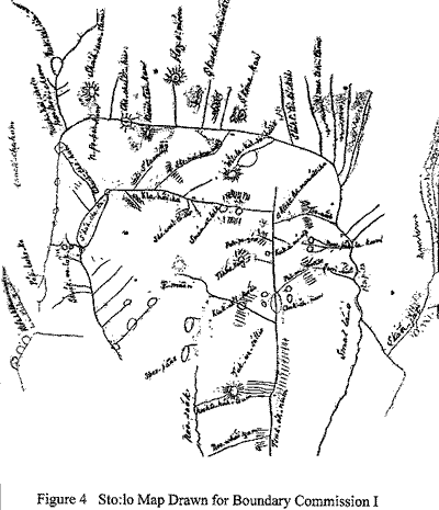
1. Rivers and streams are often anastomosed, that is, joined at the headwaters. This rarely occurs in nature but is common on Native American maps, usually representing routes of travel. Native American cartographers depict the overall transportation system not whether one segment could be canoed while another had to be walked.
2. Native American cartographers often use a "variable scale," not being confined to a consistent scale as with European maps. Scale in Native American maps often relates to relative importance, therefore the disproportion that is immediately striking in Native American maps is actually a clue to what areas are considered more important.
3. Distance is often measured by length of time taken in travel. Relatively unimportant streams are noted as straight lines because they are landmarks noting progress in travel rather then important topographic features.
With these distinctions in mind these two maps reveal a detailed Sto:lo knowledge of the NOCA area from the upper Skagit River to the gorge above Newhalem. Also the Chilliwack, Baker and Nooksack River Valleys are detailed.
Figure 4 shows place names from "Shaw-wa-tum" on the Skagit River (just north of the Canadian border) to below the gorge. Place names are also in evidence for the upper "Noo-saak" (Nooksack River), "Kla-hai-hu" (Chilliwack River), and "Tsuk-ek-num" (Baker River).
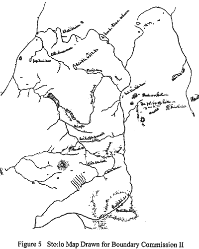
Figure 5 illustrates anatomosed river systems connecting the Chilliwack to the Skagit and the Baker Rivers suggesting that these were trail systems. A later map of the Chilliwack area by Wells (1966) illustrates some of these trails and records some similar place names (see Figure 6). Together these maps offer a rare insight into the Sto:lo perception of NOCA in the mid-1800s. Study of these maps could be pursued further by obtaining glosses of the place names. Often Salish place names are an indication of resource use or other features of the land. A narrative account of Custer's exploration of the Skagit River from the Canadian border to below Ruby Creek is found in Luxenberg (1986:19-28).
3.2 The Nooksack
Basing his decision on which tribes to include in Ethnography of the North Cascades Smith relied heavily on the tribal distribution study by Spier (1936). In turn, Spier often relied on secondary data from sources compiled by individuals who never worked directly with the groups in question. For example, Spier described the Nooksack territory based on the reports of federal employees, mostly Bureau of Indian Affairs, who were often relying on second-hand information.
Above the Lummi, on the main fork of the river which is said to rise in and carry off the water from Mount Baker, is still another considerable tribe called the Nooksahk. They seem to be allied with the Lummi and Skagit, and, according to Indian account, they speak a mixed language. (Spier 1936:38).
The Nooksack are not well known ethnographically. There is, nevertheless, unpublished information that can be used to delineate their use areas a little more carefully.
The Nooksack River consists of three main branches and along these valleys important travel routes connected to the Chilliwack River Valley, via the north fork of the Nooksack River; Mount Baker and the Sisters, via the middle fork; and the Samish and Skagit Rivers via the south fork (Richardson 1974). It is presumptuous to assume that these trails, especially to the Chilliwack, were only used by non-Nooksack groups. While explicit evidence is lacking it does appear that the Nooksack traveled deep into the North Cascades for hunting, gathering, trade and other purposes.
Fetzer, in testimony before the Indian Claims Commission, identifies use of the mountain areas "east of Mount Baker" for hunting mountain goat, bear and deer and for gathering berries (1950:20). Other accounts outline Nooksack land use patterns without specifying locations in or near NOCA (Hawley 1945; Jeffcott 1949; Smith 1950; Amoss 1972; Tremaine 1974). The Nooksack were especially noted for their production of woven mountain goat wool blankets. These animals were hunted and the shed wool was gathered in the alpine areas of the North Cascades. Presumably this would have taken the Nooksack into NOCA lands as the western boundary of NOCA is just east of Mount Baker.
Testimony presented in the 1920s land claims case Duwamish et al. v. United States also is suggestive of use of NOCA lands. For example the testimony of Ellen Seekanem (1934:510, 514):
Question: Was your country bounded on the east by the Upper Skagits?
Answer: Yes.
Question: Did your country reach as far to the east as Mount Baker?
Answer: Yes, it goes up to the mountains.
Question: The Skagits lived in the country to the east of your people, did they, at the time of the treaty?
Answer: Yes she says they lived up on the Skagit River.
This description seems to place the Skagit in the area of what is now Ross Lake and the Nooksack immediately adjacent to the westward.
The only detailed study of the Nooksack is Amoss's (1978) analysis of contemporary religious practices. Amoss mentions how Nooksack spirit dancers require bathing, fasting, and isolation in wild and desolate places. Often the mountains provided these places. It is the nature of these practices, however, to keep the locations secret. Therefore it is difficult to ascertain the extent of use or the sites where these activities take place.
The Nooksack never removed to a reservation and in the late 1800s Indian homesteads were established. These homesteads were located near traditional village and fishing sites along the Nooksack River enabling the Nooksack to remain in their traditional homeland along the foothills of the Cascade Mountains. From these homesteads the Nooksack continued to make seasonal trips to fishing, hunting and gathering locations. Jeffcott mentions the Nooksack "sphere of influence" as encompassing the environs of Mount Baker and the Sisters Range where they hunted for deer, elk and mountain goat (1949:43). Many Nooksack men were also employed in the logging industry which was very active in the area of the Cascade Mountains throughout the 1900s.
As Euroamerican settlement progressed up the Nooksack River Valley the Nooksack retreated further into the mountains to pursue traditional activities. These activities today include hunting, gathering of plant foods and resources, and ritual bathing and fasting. The Mount Baker-Snoqualmie National Forest Land Management Plan (1990) identifies five categories of use of Forest lands by the Nooksack: spirit quest sites; legend sites; cedar areas; ceremonial floral areas; and archaeological sites and cemeteries. The Mount Baker-Snoqualmie National Forest is immediately adjacent to NOCA, sharing most of its western boundary. It is therefore safe to assume that these activities include NOCA lands as well.
To specifically identify Nooksack uses of NOCA lands will require oral histories. Nooksack traditional and contemporary land use patterns are not explicit in the ethnographic or historical data. To fully evaluate the extent of Nooksack dependence on NOCA lands further data is needed.
3.3 The Upper Skagit
For the Upper Skagit Smith (1988:3-58) identifies three winter villages within NOCA, a system of trails that criss-cross NOCA and subsistence and ceremonial uses. Based on Collins's (1974) ethnography and her earlier work for the Indian Claims Commission the descriptive account of the Upper Skagit is fairly complete. Additional data derived from explorers' journals of the mid to late 1800s (Linsley and Tennant 1870; Klement 1877; Merriam and Symons 1879; Pierce 1882; Robertson 1883; and Rogers 1887) describe Upper Skagit along the Skagit and Cascade Rivers. These explorations were in search of transmontane travel routes or mineral resources. The explorers followed Native trails and most used Native guides. The Klement expedition of 1877, for example, depended upon Skagit guides to show them the route through the mountains to Lake Chelan. Following Native trails they were led up the Cascade River and over Cascade Pass. From there they descended to Lake Chelan where they found canoes the Skagit kept at the head of Lake Chelan. Traveling down the Lake they noted the home of a Chelan who operated a small trading post.
The Upper Skagit avoided removal to the Swinomish Reservation and in the late 1800s several Indian homesteads were filed on lands along the Skagit Valley from Concrete to Newhalem. One of these homesteads, owned by two brothers John and Sam Enick, is located in Ross Lake National Recreation Area at the mouth of Damnation Creek. Other homesteads were located downriver outside of NOCA boundaries and along the Cascade River. These upriver homesteads provided important links to the mountain areas including the continued use of trails well into this century. Vi Hilbert, instructor of the Skagit language at the University of Washington, recalls oral traditions from her father of trips they made over Cascade Pass to visit relatives on the east side of the mountains. Likewise, a wealth of oral traditions concerning Upper Skagit uses of the trail systems and other NOCA resources await recordation.
3.4 The Sauk-Suiattle
The Sauk-Suiattle have been recognized by the federal government since 1973 although they were often treated as a tribe separate from the Upper Skagit well before. In the Point Elliott Treaty of 1855 the "Sahkumehu" signed separately from the other Upper Skagit bands. Smith (1988) includes the Sauk-Suiattle (whom he calls the Suiattle-Sauk) with the Upper Skagit but since they have historically been considered a separate tribe and are so treated today I believe they should be discussed separately.
The Sauk-Suiattle were inhabiting the Sauk and Suiattle River Valleys at the time of first Euroamerican contact. They are often described as having a dependence on the resources of the mountain areas and more contact with the Native people east of the mountains. Unlike many of the tribes that were party to the Treaty of Point Elliott the Sauk-Suiattle did not have a reservation established in their homeland and most refused to move to either the Swinomish or Tulalip Reservations as they were instructed to do by the Bureau of Indian Affairs. As a result, when Euroamerican settlement commenced conflicts arose between the Sauk-Suiattle and the Euroamerican homesteaders. From 1855 to the 1880s the Sauk-Suiattle persisted in their traditional homeland. A few vain attempts were made by the agents of the Bureau of Indian Affairs to move them to a reservation but so long as there were few Euroamerican settlers in the area the Sauk-Suiattle were able to persist.
There is . . . a small band or remnant of a tribe, under the leadership of John Campbell, living on the Upper Skagit River, who refuse to live on the reservations or adopt the customs of civilization. They are in communication with the Indians east of the Cascade Mountains, and seem to be acquainted with all the movements there. (ARCIA 1880:165)
By the 1860s the Sauk-Suiattle had concentrated at the main village at Sauk Prairie, and by the 1880s it consisted of eight longhouses (Sampson 1972:23). In 1884 Euroamericans homesteaded the Sauk Prairie. According to Lawrence Joseph while the Sauk-Suiattle were away at fishing camp Euroamerican settlers burned some of their longhouses and split the cedar planks of other longhouses into fence rails. When the Sauk-Suiattle returned to find their homes gone they attempted to reclaim their land but were driven off. The Sauk-Suiattle sought assistance from the Bureau of Indian Affairs but the local agent refused to deal with them because they were off-reservation. Finally, under the direction of two leaders, they moved into the Suiattle River Valley where Euroamerican settlement had not yet reached.
The Sauk-Suiattle lived unmolested in the Suiattle River Valley for ten years until Euroamericans began moving into this area too. Under the advice from Euroamerican friends the Sauk- Suiattle filed for Indian homesteads (ARCIA 1903:40) According to the report of a forest ranger there were "five or six" longhouses in the Suiattle River Valley in 1890 (Farrar 1907:5). Little is known about the Sauk-Suiattle during this time but as near as can be pieced together they were living in the winter villages and dispersing to resource-gathering locations in the spring and summer, following a traditional round of subsistence activities which included the high mountain areas and movements east of the mountains to the Chelan and Wenatchee Valleys (Bruseth 1972:6 ff.) In 1897 most of the Suiattle River Valley was withdrawn for the creation of Washington National Forest (one of the predecessors of Mount Baker-Snoqualmie National Forest). Since the Sauk-Suiattle had lived in the area prior to the creation of the Forest they were allowed to maintain their homestead allotments, however the Forest Service began a long process of cancelling the Indian homesteads, a process which was finally complete in 1928. Some of the Sauk-Suiattle removed to the Swinomish or Tulalip Reservation at this time but many remained behind scattering along the Sauk River or settling near the Euroamerican settlements in the area. Here they persisted by wage labor, such as logging, and subsistence hunting, fishing and gathering.
The Sauk-Suiattle were party to the 1934 land claims case Duwamish et al. v. United States and filed a claim with the Indian Claims Commission in the 1950s (Docket 97). The Indian Claims Commission case was dismissed and the Sauk-Suiattle combined with the Upper Skagit (Docket 93). The Sauk-Suiattle persisted in maintaining their separate identify and in 1973 achieved federal recognition and a small reservation in Sauk Prairie.
The ethnohistorical data on the Sauk-Suiattle are also sparse. The Linsley expedition of 1870 used Sauk-Suiattle guides in their explorations of the North Cascades for a possible railroad route. Two routes, which followed Native trails, were explored. One went from the Suiattle River to Lake Chelan via the Suiattle Pass-Agnes Creek route. This trail is also depicted on Gibbs's 1860 map (see Figure 7). The other route followed the Sauk River over Indian Pass and down the Wenatchee River (Linsley 1932). The first route is the one that brought Sauk-Suiattle into NOCA lands. While the Sauk-Suiattle use of NOCA lands appears to have been limited there is sufficient evidence to conclude that it at least included transmontane travel and interaction with the Native peoples east of the mountains, especially the Chelan and Wenatchi (Bruseth 1972:6). Further evidence is lacking from the ethnographic and historic data base.
3.5 The NLakapamux
The NLakapamux (formerly known as the Lower Thompson) are discussed at length in Smith (1988:145-250). Of their territory he says it:
. . . followed the Cascades crest from the present international line, describing an arc to the southwest around the headwaters of Lightning Creek. It crossed the upper Skagit River - today's Ross Lake - just above the mouth of Big Beaver Creek and headed westward over the mountains to the uppermost reaches of Baker River and Mount Shuksan. Thence it curved to the northwest to the Mount Baker region, crossed the North Fork of the Nooksack River in the Glacier area, and finally bent northeastward to arrive at the Canadian boundary of Sumas Lake, now drained. (Smith 1988:148)
Today the NLakapamux live entirely on the Canadian side of the border but maintain an interest in their traditional lands in the United States. It is not clear from the historical data when movements south of the border ceased. In 1869 Edmund Coleman, while attempting an ascent of Mount Baker, noted that his Nooksack guides became agitated when they recognized a NLakapamux tree blaze in their area. NLakapamux worked as packers along the Skagit trail and accessed the NOCA area well into the 1900s for subsistence purposes (Teit 1900). More recent information (e.g. Turner 1978; Turner, et al. 1980) focusses on plant procurement but does not mention any sites south of the border. Nevertheless in 1992 during the Federal Energy Regulatory Commission hearings on the relicensing of Ross Dam the NLakapamuk sought and were granted intervenor status as a concerned party. According to Bob Pasco, Grand Chief of the NLakapamuk Nation, the NLakapamux maintain an interest in their traditional homelands in the United States even though they are often precluded from participation in decision-making processes because they are Canadian First Nations.
It is clear from the data presented by Smith (1988) that the NLakapamux have traditional ties to NOCA lands. There is no ethnographic or historical data that can be added to his discussion. Missing from Smith's description is an account of recent historical and contemporary uses of NOCA lands and resources. The NLakapamux are presently engaged in data gathering for their comprehensive land claims against the federal government of Canada. Their published claim (see Figure 3) does not extend south of the border. It may be that as the data gathering process proceeds that information will come to light concerning NOCA lands. At present this data is held in confidence until such time as the proceedings are concluded.
3.6 The Chelan, Methow, Entiat and Wenatchi
For reasons not entirely clear, of these four groups Smith (1988:251-305) chose to include only the Chelan as associated with NOCA. Of the Chelan he said:
The ethnographic and early ethnohistorical information concerning the Chelan and their aboriginal lifeways is so very scanty that nothing of substance can be said regarding additional uses of the Park Complex within the Chelan tribal borders. One can only hazard the speculation that to some unknown degree the region served as the source of materials or technological importance. . . . (Smith 1988:305)
Based on a somewhat crude functional analysis of distribution of mammals the conclusion was reached that the upper portion of Lake Chelan was used "by Chelan hunting and trapping parties mainly as a backup source of game and technologically useful animals" only when the mammals of the lower lake became limited for some unknown reason (Smith 1988:304-305). By focussing on the attempt to recreate the "traditional" culture of the Chelan much important information concerning their use of lands near and in NOCA were understated.
It is difficult to determine to what extent the Chelan, Methow, Entiat and Wenatchi composed separate tribes. Further complicating the issue is the fact that the Yakama Treaty appears to include the Entiat and Wenatchi but not the Chelan and Methow, even though Lake Chelan is included in the ceded lands. These groups have been treated in different ways, further adding to the complications. The Confederated Tribes of the Colville Reservation claims descendence from all four of these groups today although in the past only the Methow were claimed (although the designation "Methow" appears to have included the Entiat and Chelan). Since 1938 the rolls of the Colville has not designated tribal affiliation other than "Colville" but prior to that time the Methow were listed separately. There are definitely descendents of all four tribes on the Colville Reservation because members of these tribes were removed to Colville after the Columbia Reservation was disbanded (Ray 1957:28-29). Likewise descendents of at least the Wenatchi and Entiat reside on the Yakama Reservation.
While Smith may be justified in attempting to separate the Chelan from the other groups for the purpose of recreating the traditional culture he had to rely on ethnographic data that applied to all four, especially to the Wenatchi (Smith 1988:251). As mentioned above, part of the confusion may lie with the attempt to assign a specific territory to each of the four groups when in reality the peoples of the Plateau ranged freely and widely over lands extending far beyond those surrounding their winter villages.
Based on the present ethnographic and historic data base we cannot say with any degree of certainty to what extent these four groups utilized NOCA lands. This much we do know, the Chelan had villages along lower Lake Chelan and frequented the upper portion of the lake and the mountain passes to the north and west. To what extent these uses included individuals from the other groups is difficult to say. Gibbs's 1860 map (see Figure 7) identifies villages and place names along the Wenatchee, Entiat, Chelan and Methow Valleys. These places are connected by a complex of trails which also lead into NOCA lands. The later establishment of the Columbia Reservation for these groups clearly ties them to the NOCA area.
The creation of the Columbia Reservation placed Chelan, Methow and Entiat on lands adjacent to NOCA (as discussed below some NOCA lands were part of the Columbia Reservation). Although the reservation was abolished in 1883 several individual homestead allotments were retained. These are mostly located along the southeastern shore of Lake Chelan. The ethnohistory of these groups in the late 1800s is inextricably tied to the story of the Columbia Reservation and in the 1900s to the concerns over resource use and control of the Yakama and Colville Tribes.
As a non-treaty tribe the Colville do not possess the same resource rights in off-reservation areas that treaty tribes enjoy. In an effort to clarify their rights to off-reservation fishing through their ties to descendents of treaty tribes the Colville entered suit to plead inclusion under Sohappy v. Smith, (302 F. Supp. 899 [1969]). The Colville argument was based on the fact that descendents of certain treaty tribes reside on the Colville Reservation. Their argument was denied (United States v. Oregon v. Colville, 115 S. Ct. 2246 [1995]) based on the finding that:
Fishing rights under treaty belonged to the tribal entity as a whole, not to its component bands individually. Therefore, although some descendents of treaty tribes reside on the Colville Reservation this does not make the Colville a treaty tribe.
For the purposes of this case it was determined that the Wenatchi, Entiat and Chelan were party to the Yakama Treaty but although some individuals from these tribes moved to the Yakama Reservation the tribes as a whole did not. Since a number of members of the Chelan, Entiat and Wenatchi also moved to the Colville Reservation both of these present day tribes -- the Yakama and the Colville -- are both successors to the Chelan, Entiat and Wenatchi. The case did not deal with the Methow and it is not clear if the Methow were included with the Chelan or if they were not considered in this case because they are not associated with a treaty and solely belong to the Colville Reservation.
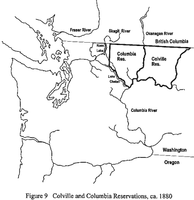
The Colville Reservation was created by Executive Order in 1872 and unlike treaties Executive Orders generally do not clarify off-reservation rights to resources. To further complicate matters the Colville also claim jurisdiction over the former Columbia Reservation. The Columbia Reservation was created by Executive Order in 1879 at the urging of Moses, leader of the Columbia band. At the creation of the Columbia Reservation (see Figure 9) the Chelan, Entiat, Methow and Wenatchi were included with the Columbia as "Moses' Band of Columbia Indians." When the Columbia Reservation was abolished in 1886 they were to remove to the Colville Reservation. Some removed, some remained behind on individual allotments, some Wenatchi went back to the Wenatchi Valley and some eventually went to the Yakama Reservation. Many Chelan refused to leave and were forcibly removed by the U.S. Army in 1890.
As it appears now the Colville only retain off-reservation rights to areas of their former reservation in addition the rights guaranteed to all recognized tribes under federal laws. In Antoine v. Washington (95 S Ct 944 [1975]) two members of the Colville Tribe were cited for hunting deer out of season. They argued that because they were on lands formerly part of the Colville Reservation that State laws did not apply. This case eventually was heard by the Supreme Court which agreed. One consequence of this case was that in 1995 the Colville asserted hunting rights over the former Columbia Reservation. To date this action has not been contested. Since parts of the former Columbia Reservation extend into NOCA lands this action becomes especially important. However, it becomes more complicated as the jurisdiction of National Parks becomes a consideration. This issue is discussed at length below.
To summarize, little data exists on the nature of land and resource use of NOCA by the Chelan, Entiat, Methow and Wenatchi. It is clear that these groups utilized NOCA lands but further data is needed to ascertain the nature and extent of that use. For practical purposes these four tribes no longer exist and both the Colville and Yakama Tribes are their heirs of succession.
| <<< Previous | <<< Contents>>> | Next >>> |
noca/ethnographic-overview/chap3.htm
Last Updated: 10-Nov-2016