|
North Cascades
Ethnography of The North Cascades |

|
CHELAN
| DATA BASE |
Consistent with the procedure adopted in the preceding chapters, the summary of the traditional life patterns of the Chelan presented in the following pages represents a merging of the available ethnographic and ethnohistorical data. Unfortunately both sets are singularly meager, requiring a special fall-back and not very satisfactory descriptive procedure that must be explained.
The ethnographic information for the Chelan is essentially limited to casual remarks in ethnographic studies of nearby tribes. Fortunately, however, they were one tribe in a small cluster of regional groups that possessed quite similar life patterns: the Chelan, the Methow of the Methow Valley immediately upstream, and the Entiat and Wenatchi in their own valley systems below on the Columbia (Figure 4-1). Accordingly, in theory it should be possible with caution to extrapolate from the traditional life habits of the last three groups to those of the Chelan. As a practical matter, however, this is possible to only a limited degree, for the Methow and Entiat are ethnographically as poorly described as the Chelan. The Wenatchi, in contrast, are measurely better known, thanks largely to the single study by Ray (1942). The best that can be done is to make maximum use of what little Chelan information is available, extending it by reference to relevant Wenatchi data. Because the Chelan data are so scanty and that for the Wenatchi so much fuller, the pages that follow often have the appearance of a Wenatchi study with occasional references to the Chelan, expanding upon, confirming, or altering the Wenatchi ethnographic facts to the explicit Chelan situation.
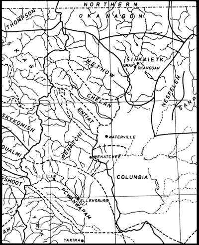
Figure 4-1. Approximate traditional territorial boundaries of Chelan, Methow,
Entiat, Wenatchi, and Columbia. The Sinkaietk are the Southern Okanagan.
(After Spier 1936:42-43, modified by addition of Entiat, elimination of
Sinkaqai'ius as a tribal entity, and redesignation of Middle Columbia as
Columbia.)
This "altering" aspect calls for further comment. While the Chelan and Wenatchi evidently shared many basic cultural traits (Ray 1939:145-149; Teit 1928), they are either known or can be reasonably presumed to have differed in at least some segments of their lifeways. In the first place, no two tribal groups in the Plateau, however close geographically, followed precisely the same constellations of cultural patterns, just as every group had its own speech peculiarities. These differences in cultural behavior were fostered by a mixture of circumstances of varying importance: the influence of different sets of past leaders and community pattern-setters, contacts with a somewhat different groups of tribes, and other differences in their histories. But a factor of generally greater importance was the special features of the ecological niches to which the culture of the group was adapted. In the case of the Chelan and Wenatchi the two tribes occupied rather difference bioenvironments. That of the Chelan was a unique riverine-lacustrine and intensely mountainous one: while occupying a short stretch of the Columbia Valley, they were essentially a lake people, maintaining most of their camps and winter villages on the shores of Lake Chelan and exploiting in particular the small streams and timbered mountain slopes draining into the lake (Smith 1983). The effective bioenvironment of the Wenatchi, in contrast, was largely a riverine one, their mountains playing a lesser role in their life: the tribe lived on the banks of the Columbia and even more importantly along the Wenatchee River and its major tributaries and made great use of these stream resources, including hordes of salmon in season. To the extent possible, this study makes a particular point of identifying the cultural consequences of these environmental differences.
The Columbia "tribe" (the "Moses Columbia" of the latter part of the nineteenth century) on the eastern side of the Columbia River are sometimes linked, as noted below, with the Chelan, Methow, Entiat, and Wenatchi into a "Middle Columbia (Salish) group." After the Wenatchi, the Columbia are ethnographically the best known of this larger cluster. Yet in this present report, these Columbia data are not widely referred to, since, in spite of a deeply rooted life-mode similarity, their culture rested on a third ecological base, one including a Columbia Valley segment and a major part of the dry Columbia Basin with its steppe and shrub-steppe vegetation (Franklin and Dyrness 1973:6, 45). Further, their lifeways in posthorse times tilted toward those of the bison-hunting Sahaptian neighbors to the south. The Columbia cultural data are, therefore, only marginally useful in the Chelan context.
In the interests of clarity, an effort is made to assign data explicitly to the Chelan or Wenatchi (or occasionally to some other group). Where not so identified to avoid tiresome repetition, the information is to be understood as Wenatchi-specific.
The greater part of the limited ethnographic data for the Wenatchi is to be found in Ray's (1942) culture element survey. This provides detailed information concerning many segments of traditional Wenatchi lifeways, though this is less rich than for other groups investigated at later times in his field research period. There is, however, a problem in the use of these data in terms of this present study; because they are recorded in an individual item-list fashion, the functional relationships between items and especially between item clusters are neither invariably apparent nor always reconstructable with assurance. Thus weir and fish trap elements are cataloged separately, rendering it difficult to sense how the weirs and traps were combined in organic complexes. Specific instances of this kind are noted in the ethnographic summary that follows.
A second difficulty lies in the interpretation of Ray's (1942:104) symbol "( )," which he explains as indicating that "informant qualified answer by terms such as 'sometimes' or 'a few.'" But in his tables he uses both (+) and (-) without defining the difference between the two. Perhaps (-) signifies "sometimes absent," implying that the trait was generally present, and the opposite for (+). This interpretation seems improbable to me, but I really do not know. Accordingly, I have opted for translating the two identically to indicate 'sometimes,' 'occasionally,' or 'a few.' Thus: "Traps: withes of fir (+)" (Ray 1942:107) might be reported in this study as "traps were sometimes made of fir withes" or "a few traps were fashioned of fir withes." And Ray's (1942:111) "eel hook (-) might here appear as "the Wenatchi had a few eel hooks" or "they occasionally used hooks for eels."
A third point in regard to my free use of Ray's survey data: in most instances I pass over his negative data entries. Plateau informants even in the 1930s were unaware of the full richness of their traditional culture. This was especially true, of course, of those cultural traits that disappeared soon after first White contact. But their native lifeways were, in general, characterized by alternative ways of achieving the same objective. Surely this was partly a response to a typically broad range of bioenvironments within the country of a single tribe. But it appears also to have been partly related to their basically loosely structured society in which individual choice and experimentation were not only permitted but fostered. As a consequence, no informant, however knowledgeable, could be expected to be well acquainted with the variant behavior patterns followed by only a few tribal members or that had been practiced under peculiar, infrequent conditions or in atypical geographic sectors of the group's territory. Negative evidence is, in short, somewhat tainted by these circumstances.
Fourth, the Wenatchi were the first group surveyed by Ray, using a list of traits that was very incomplete in comparison with the expanded element roster that guided his later inquiries among other tribes. Accordingly, the failure of a cultural trait to be mentioned in the following survey as an aspect of Wenatchi culture cannot be interpreted as necessarily indicating its absence among the group.
Finally, Ray's Wenatchi data have been subjected to a careful cross-checking process. This is necessary since traits are sometimes mentioned in one context but not elsewhere where they might be expected to appear. One illustration: bark baskets are noted as Wenatchi water carriers in the "Utensils and Dishes" section, but the entire "bark basket" section is left blank for the Wenatchi, evidently indicating only that no data were gathered as an inquiry unit concerning bark containers (Ray 1942:140, 160-161). Still, I have doubtless overlooked some dispersed data of this kind.
Not included in this Chelan section are data reported by Teit (1928) for his Middle Columbia Salish cluster except where the Chelan are mentioned specifically or inferentially. It is often impossible to determine -- at least as presented under Boas' editorship -- whether tribally unassigned data apply to all the Middle Columbia peoples -- Chelan, Methow, Entiat, Wenatchi, and Columbia -- or to some limited segment of this large cluster. When "Wenatchi" are identified specifically with data, it is uncertain whether this information describes the situation for the Wenatchi tribe alone or for the entire "Wenatchi" group -- the Chelan, Methow, Entiat, and Wenatchi proper. Incidentally, in gathering these Middle Columbia ethnographic facts, Teit (1928:89) apparently relied on Columbia and Wenatchi informants, having had none from the Chelan and Methow. Evidently Ray's "Wenatchi" data, on the other hand, relate only to the Wenatchi people and so possess in this present context the particular merit of tribal specificity.
Early historical documents relating specifically to the Chelan area are likewise not numerous. To this point, no more than 19 dating to the 1811-1850 period have been identified as concerned with the Columbia Valley segment of the aboriginal territory of the Chelan; only one is known for the Lake Chelan area.
The Columbia River data may be considered first. It may seem surprising that there are so few accounts of travels through the area in this initial 40 year period, particularly in view of the very considerable annual movement of Euroamerican traders up and down this major river highway and, later in the period, the journeys of missionaries and casual travelers. Unfortunately, however, most of these travelers kept no record of their goings and comings: many were men who were bold adventurers and fine canoemen but who possessed little education. Others apparently chronicled their adventures only to have them lost or still curated as archives. Of those riverfarers whose accounts have made their way into print, some report on only one or two of their several journeys, or reduce their daily travels to only the barest essentials, or recount their journeys in narrative form too deficient in specifics to be helpful. And virtually all slight the Chelan and middle Columbia segment of their river travel. How can this patent disinterest in this particular region be explained?
To understand this circumstance, it is necessary first to review briefly those segments of these published, pre-1850 travel accounts that concern the Columbia Valley in Chelan territory. Whatever ethnographic data are provided are not included here but are integrated into the culture-descriptive sections to which attention is soon turned.
- In early July, 1811, David Thompson (1914:52, 1962:344-345; Smith 1983:25-35), descending the Columbia from Kettle Falls, evidently saw no Indians in Chelan country. As the first White man to traverse the river from Kettle Falls to the Snake River confluence, he had "as usual" put ashore when he had observed villages of the Sanpoil, Nespelem, and Methow and as he later did at the Columbia village at Rock Island. Both as a matter of trading strategy and to insure his safety when he expected later to ascend the river slowly against its strong current, placing him at a disadvantage in case of native hostilities, he stopped wherever he found an Indian camp to explain the purpose of his journey of exploration and to smoke with its occupants (Glover 1962:344). While he is entirely silent on Indians in this Chelan sector, the fact that he passes the area without pause seems proof enough, in light of his expressed and observed policy, that he noticed no native camps in this distance. These data are of special interest not only because they report the initial Euroamerican journey through the Chelan sector of the Columbia, but also because they have implications for an understanding of salmon fishing among the Chelan, a matter discussed below in the fishing context.
- In late August, 1811, Alexander Ross (1966:103, 139-142, 289-290; Smith 1983:43-51) canoed up the Columbia from Astoria on his first upriver journey. Passing through Chelan territory, he observed "a small but rapid stream, called by the natives Tsill-ane, which descended over the rocks in white broken sheets." Indeed, he was even informed by the Indians that "it took its rise in a lake not far distant," the first reference to Chelan River and Lake in the historical literature. A short distance farther up the Columbia he met "some Indians," put ashore, and encamped for the remainder of the day and following night. Precisely where this encounter took place is uncertain. For several reasons, however, the location seems to have been about 6.5 miles upstream from the Chelan confluence (Smith 1983:49-51) and at any rate within Chelan territory. Ross' few observations concerning these "very friendly, communicative, and intelligent" people -- surely Chelan and the first Chelan seen by Whites in their own country -- are noted in the following culture-descriptive sections.
- In April, 1814, Alexander Ross (1956:21-31; Smith 1983:51-59) again ascended the Columbia River, on this occasion with a flotilla of watercraft. In his travel record no mention is made of the Chelan or their country as he moved up the river. Nor is attention directed to either when, a few days later, he left the area of the Okanogan confluence and rode horseback down the Columbia through the Chelan sector to the Kittitas Valley in search of horses and then, with purchased animals, returned along the river trail to the Okanogan Valley.
- Gabriel Franchere (1854:276-280; Smith 1983:59-63), a member of Alexander Ross' large boat brigade of April, 1814, makes no mention of seeing Indians along the riverside between Priest Rapids and Kettle Falls.
- By his own account, Ross Cox (1957:5, 218-227, 256; Smith 1983:63-66 made several journeys up and down the Columbia River between the mouth of the Snake and the confluence of the Okanogan. For most of these watercraft passages, we are favored with no information. In November of 1815, he relates however, the frail bark canoes and cedar-plank boats of his party were halted by river ice, as they moved up the Columbia. This point of blockage was certainly below the Chelan region, at Rock Island I believe on the fragmentary evidence provided. In mid-February, 1816, after a hard winter's encampment and following the breakup of the river ice, Cox and most of his group continued their water journey upstream to the Okanogan, mentioning no Indian sightings en route.
- In April, 1817, Ross Cox (1957:268, 271-272; Smith 1983:66-71) undertook his final journey up the Columbia from Fort George, on this occasion in a party traveling in two barges and nine canoes. Again, unfortunately, he mentions no Indians as he traversed the distance from Priest Rapids to "Fort Oakinagan."
- In late June and early July, 1817, Alexander Ross (1956:94-95;
Smith 1983:71-73), traveling in a boat of the North West Company
brigade, made his way through Chelan country. While he mentions no
Indians specifically for this section of the Columbia, he writes on
leaving Priest Rapids:
Though some slight room exists for interpreting these comments regarding band numbers as applying only to the troublesome groups downriver from Priest Rapids, it seems, coming at the close of his brief journey account as it does, to apply to his entire canoe experience from Fort George to the Okanogan. This would include the segment of the Columbia River from Priest Rapids to the Okanogan confluence and so pre sumably to the Chelan territory. Yet whether any of these "bands" were in fact at the riverside within Chelan boundaries remains problematical. In any event, these statements are of considerable general importance in revealing, through the eyes of a competent and experienced observer, the extent to which Indians varied greatly in their numbers along the river from year to year and season to season, but more significantly at the same season from year to year. And, furthermore, that this variation occurred during the first decade of Euroamerican contact.Henceforth we travelled among those more friendly [Indians] as we advanced towards the north. The innumerable bands of Indians assembled along the communication this year rendered an uncommon degree of watchfulness necessary, and more particularly as our sole dependence lay on them for our daily subsistence. I have passed and repassed many times but never saw so many Indians in one season along the communication; . . .
On arriving at Oakinacken . . . I set out immediately for my winter quarters at the Shewhaps [Shuswap], . . .
- Early in November, 1824, George Simpson (1931:36-53) descended the Columbia from the Boat Encampment at the foot of the Rockies. Below the Okanogan he notes passing "a small River." That this can only have been the Chelan River I have elsewhere demonstrated (Smith 1983:73-75). Importantly, he states explicitly that he "Saw no Indians on the communication to Day," i.e., during the day when he passed through the Chelan territory. Were the three and perhaps as many as five Chelan winter villages reported ethnographically to have been located on the west bank of the Columbia not occupied that winter for some reason, for surely they should have been in their cold season settlements by November? Or were the dwellings, on the river terraces, subterranean pit structures with earth-covered roofings raised so little above the land surface as to be invisible from canoe level? If the latter were the case, why were there no ancillary, specialized structures to be seen -- e.g., platform caches and even summer salmon and plant food drying racks, for, according to Ray (see later section), three and possibly five Chelan sites on the Columbia supported warm season camps? Interesting and, it would appear, unanswerable questions.
- On April 3,1825, Simpson (1931:130-131; Smith 1983:74-75), returning up the Columbia from Fort George in a flotilla of four boats, moved through the Chelan area without comment of any sort.
- In 1826 David Douglas (1972:71, 75, 85, 122-124; Smith 1983:75-77) journeyed through the Chelan area on no less than three occasions: the first heading up the Columbia in late March and early April; the second moving downstream in June; and the third again descending the river in August. In all of these water passages he mentions only once seeing Indians, or evidences of them, between the Okanogan mouth and Priest Rapids: on his August trip at Rock Island well below the Chelan country. This appears odd and must, it would seem, reflect nothing more than Douglas' disinterest in the native peoples, save where he needed their services. Because the salmon were still running -- he observed in August an old man spearing these fish opposite Fort Okanagan -- he had excellent opportunities to view activities at various river fisheries and summer camp sites. This would have been especially the case at the Methow Rapids where he was compelled to take to his feet down the riverside while his Indian companions ran his canoe down the fast water, and again at the Wenatchee River confluence where he encamped over night; both of these localities are reported ethnographically to have been the site of summer camps. The point, to repeat, is that no mention by early river travelers of Indian villages or camps or of Indians laying in their store of salmon cannot be safely interpreted, failing some evidence to the contrary, as signifying the absence of native communities and activities in or along the river.
- On April 4 and 5, 1827, Edward Ermatinger (1912:70-78; Smith 1983:77-83), in the York Factory express boat, followed the Columbia through the Chelan homeland. On the evening of the 4th, after having traveled the distance from his night camp of the 3rd, pitched "5 miles above the Piscouhoose [Wenatchee] River," he made camp "a league above the Clear water Creek," i.e., Chelan River. The "league" of the fur personnel at the time seems to have been about seven miles, as Simpson's (1931:52; Smith 1983:73) journal of 1824 demonstrates. This suggests that Ermatinger and his party encamped at or very near where, on independent evidence, I suggest that Alexander Ross pitched his camp on July 27,1811 (see above). Alternatively, if the dictionary definition of the league "of English-speaking countries" as about three miles is assumed to have been that of Ermatinger, then his night's stopping locality would have been approximately where his traveling party paused to sleep on April 3,1828 (see 1828 item below). On April 5,1827, he arrived at Fort Okanagan. In his journal entries of neither the 4th nor the 5th is any mention made of sighting Indians.
- In October of 1827, Ermatinger (1912:110-112; Smith 1983:83-88) and his Hudson's Bay Company party coursed down the Columbia from the Boat Encampment to Fort Vancouver. Unfortunately, Ermatinger makes no reference to any Indians between the Okanogan and the White Bluffs area below Priest Rapids.
- On April 3, 1828, as a member of the Hudson's Bay Company express of two boats bound from Fort Vancouver to the Boat Encampment, Ermatinger (1912:112-118; Smith 1983:88-89) again passed through Chelan territory. The night of that day found the party camping "2 or 3 miles above Clear Water Creek [Chelan River]." The site of this encampment, if his mileage estimate is essentially accurate, would have been very near the town of Beebe, or perhaps slightly farther upriver. Once again there is no reference in Ermatinger's account to any sighting or encountering of Indians in the Chelan region during either this day or the 4th, when, after breaking camp, the travelers negotiated the northeastern corner of the Chelan country and moved on into the homeland of the Methow.
- In late May and early June, 1828, John Work (Lewis and Meyers 1920:106-107; Smith 1983:90), with a large brigade, journeyed by boat from Fort Colvile to Fort Vancouver. On May 28, the party, aided by a strong current and by being propelled with oars rather than with paddles, traveled the entire distance from the Okanogan confluence to just upstream from Priest Rapids. While Indians are mentioned at Priest Rapids, no sightings of natives between Okanogan and these rapids are recorded. As in the case of so many of these early accounts, Work's report of this journey is one of great terseness, with no room for what he would reasonably consider commonplace and irrelevant.
- On August 8,1828, John Work (Lewis and Meyers 1920:112-113; Smith 1983:92), as a member of a brigade with nine heavily laden boats, moved up the Columbia through the lower part of Chelan country, to camp that night "a little above Clear Water [Chelan] River." Here the flotilla was met by a man with horses from Okanagan. On the 9th, Work and a companion left the watercraft and rode through the northeastern sector of the Chelan area and on to the fort. Work, whose narrative of each day's events hardly exceeds a half-dozen lines, provides no information concerning the Indians of the Chelan and Methow regions, though he reports on August 6, when the party passed Rock Island, that there were "Very few Indians in the River, and Salmon very scarce" and that in the Wenatchee sector his group "Traded some Salmon from the Indians." His informative salmon and salmon fishing remarks, coupled with the Chelan focus on the Lake Chelan subsistence area (discussed below), suggest that the few Chelan, in fact, may have been on the Columbia when Work passed, but this is, of course, in a measure conjecture.
- On June 2,1836, Samuel Parker (1842:300-307; Smith 1983:92-93) left Fort Okanagan in a bateau with two Indians and two French voyageurs. Guided by his companions and driven by the river "in full freshet," he put behind him on this first day the entire distance to a point a few miles above Priest Rapids. He fails to mention Indians in his account of this day when he rushed through the Chelan country. However, he observes on June 3, during which he traveled through Priest Rapids and all the way to Walla Walla, that salmon were "ascending the river in great numbers, and groups of Indians are scattered along pursuing the employment of catching them." And later, writing retrospectively, he contrasts the life style of the Middle Columbia Salish -- Chelan, Methow, Entiat, Wenatchi, and Columbia -- with that of the Sahaptian peoples farther down the Columbia River, the gist of which is remarked upon in a later section of this present report.
- On August 20,1841, George Simpson (1847 1:141,153-162; Smith 1983:93-94) embarked from Kettle Falls in a flat-bottomed bateau, propelled by six oars, high water, and a strong current. Driving very hard as was his headlong style, he passed through the Chelan area on his second day of travel, making no reference to Indians until he reached his evening camp at Rock Island.
So much for the early historical documents pertaining to the Chelan segment of the Columbia River. Plainly they furnish precious little information regarding the Chelan and their homeland in the 1811-1850 period. Two of these early travelers (David Thompson in July, 1811, and George Simpson in November, 1824) either explicitly report no Indian sightings along this Chelan River stretch or present data making this a safe deduction. Only one traveler (Alexander Ross in August, 1811) mentions observing and camping with Indians on the riverside in Chelan country. On three other occasions parties journeying on the river (those of Edward Ermatinger in April of 1827 and of 1828, and John Work in August, 1828) encamped for the night on the river bank in Chelan territory yet fail to note Indian sightings within Chelan borders. In the remainder of the water passings identified above -- 13 out of the total of 19 -- the travelers moved through the Chelan homeland without pitching camp within the Chelan boundaries and without so much as a word concerning Indians. These last 16 river boatmen whose travels have been brought to print may have observed no signs of residential units or of Indians themselves, or, seeing them, may have simply neglected to mention the fact. This question deserves some attention for what it reveals concerning both these early Euroamerican river users and the Chelan and their traditional life style.
Why might it be expected that these travelers along the water highway would have seen Chelan or at least their cultural marks in passing through their country? For several reasons, among which the following appear the most persuasive:
- The river journeys summarized above were distributed through nine months of the year: only September and, not surprisingly considering the cold season conditions of the river and the severe winter traveling problems in general, December and January saw none.
- According to the ethnographic evidence (Ray 1936:141; 1974a:419, 423), the Chelan maintained both winter villages and warmer month camps along the Columbia riverside. Four of the documented 19 early travels were made in the period from late October through March. During this season all Chelan villages on the river might reasonably be expected to have been occupied. Warmer weather river journeys were more frequent, 15 from April through September: specifically April (5), May (2), June (2), July (2), and August (4). During at least some of this open time-span, residents should have been in or near their "summer" camps (Ray 1936:141; 1974a:419-423) along the riverbanks. At least one of these summer settlements was a fishing -- presumably salmon -- camp (Ray 1974a:423). In the midst of the salmon time, some fishermen from this camp and other river bank camps should have been observed at the tribal fisheries, perhaps at the two rapids below the Chelan confluence termed by Symons (1882:maps 14,15) Downing's Rapids and Bar Rapids and even at his three "ripples." Surely, especially in view of the important Chelan summer food resource region around Lake Chelan, open season camps would not have been maintained on the Columbia River unless salmon fishing and probably plant collecting afforded serious subsistence opportunities. Further, the people of these Columbia River winter and summer communities must have engaged year-round in other subsistence tasks and technological pursuits along the river terraces and facing hillsides: e.g., hunting and plant gathering in season, food drying and storage, mat and basket making, hide tanning.
- As reported above, one trader (Ross in August, 1814) rode on horseback round trip along the river trail through the entire Chelan territory, and one (Work in May, 1828) negotiated the northern end of the river path out of Chelan country aboard a horse. While stream voyagers might have been fully occupied in forcing as much water behind their craft as possible -- as was certainly sometimes the case -- or in otherwise managing their canoe or boat, thus missing Indians on the river and Indian encampments on the stream bank, these two land travelers must have had an unparalleled opportunity for seeing Chelan at or in the vicinity of their summer river camps. Yet neither so much as mentions catching sight of an Indian or any Indian sign while within Chelan borders.
On closer examination, however, the infrequency of historical references to Indians in the Chelan River sector becomes rather more comprehensible.
- With few exceptions, travelers were intent on making as expeditious a traverse as possible through the Chelan homeland and, in fact, through the entire Columbia Basin river reach. The nearest trading posts were at the Okanogan River mouth above and the Walla Walla confluence below, the two posts between which the watercraft were generally moving. The Chelan region offered nothing of commanding interest in terms either of native groups or of commerce: the Chelan were simply too culturally unspectacular and too poor in traders' terms to warrant breaking a journey.
- The Chelan were wholly inoffensive. Between the Okanogan and Priest Rapids only a single falls, that at Rock Island well downstream from the Chelan southern boundary, generally required landing and portaging, though under certain water conditions a few rapids caused small problems, including a bit of fast water just below the Chelan River confluence. When navigational difficulties occurred and moving impedimenta for a short distance along the river bank became a necessity, the Chelan, like their immediate neighbors, exhibited none of the annoying and often dangerous aggressive tendencies common among the native groups of the lower Columbia. There was no cause for a traveler in Chelan country to note Indian presence on such occasions.
- Relatively few Chelan maintained their residence either in winter or in summer along the Columbia. On ethnographic evidence (Ray 1936:141; 1974a:419, 423), only six residential sites were located on the riverside. For two of these the season of occupancy is undescribed; of the remaining four, one appears to have been used only in winter, one in summer, and the other two in both seasons. This compares with eight winter villages around Lake Chelan and 11 summer month camps (Smith 1983:264). Clearly the Chelan population was concentrated in the lake section (see demography unit below).
- Even the April clustering of journeys may help to explain the infrequent references to Indians on the river. Too early to begin activities at the Columbia River fisheries, the people were almost certainly scattered out on the early spring collecting and hunting grounds, following the seasonal activity pattern of the Sanpoil (Ray 1932:27) and Southern Okanagan (Spier 1938:11).
- The Chelan area attracted no early missionary interest of significance. Perhaps the tribe was first exposed to formal Christianity in 1838 when the Catholic priests Blanchet and Demers journeyed down the Columbia River and therefore necessarily passed through Chelan territory. From time to time while en route they stopped, as they did also in later years, to instruct briefly and baptize native groups residing on the river banks (Byrd in Durham 1972:11 fn. 20). Whether the Chelan received these ministries I do not know. At any rate, nothing like the early, extensive, and informative records of De Smet, Spalding, the Walkers, and others for the eastern Plateau exist for the Chelan -- not even for the other Middle Columbia Salishan groups. Perhaps as early as 1858, however, Catholic services were held at Wapato Point, a bit of land extending out into Lake Chelan near Manson (Byrd in Durham 1972:9 fn. 19, 11 fn. 20), but information concerning these religious contacts seems also to be wanting.
In sum, it may be concluded from these data, supported by additional information presented later, that:
(a) Early travelers on the Columbia in the Chelan homeland normally had no incentive or occasion to come ashore except to serve their own immediate purposes, as to take meals and encamp for the night;
(b) White boatmen traveling the river should have observed from their passing craft, even though they were moving in haste, some Indian villages and camps on the stream terraces and some Indians at their tasks;
(c) Travelers who kept journals evidently considered their sightings of Indians within the Chelan borders too trivial to record;
(d) Sightings were probably fewer than might be supposed because the Chelan population along the Columbia was not large, the tribal center being rather in the Lake Chelan region; and
(e) Sightings were less frequent than might be expected because salmon fishing was for the Chelan a less important Columbia River activity than it was for other nearby river tribes and because, as Teit (1928:114) observes for the Chelan and the Middle Columbia Salishan groups in general: "Much of the summer and fall season was spent on the higher grounds, hunting, root-digging, and berrying."
It is unclear, in short, how best to balance out haste and disinterest on the part of the early passersby on the one hand and, on the other, the relevant aspects of Chelan population distribution, seasonal movements, and other cultural factors as contributors to the general failure of the river travelers to note Chelan presence along the Columbia in the 1811-1850 time span.
To place these Chelan data in perspective it is instructive to view them within a slightly broader geographical context. In the records of only two of the 19 river journeys precised above -- those of Thompson and Ross, both in 1811 -- are the Methow, above the Chelan, mentioned and in not one is the existence of Indians in the Entiat country, immediately downriver from the Chelan, attested to. Obviously, the Chelan were no more slighted by these early stream travelers than were their adjacent Salishan neighbors. Evidently the same complex of circumstances that was responsible for the 1811-1850 inattention to the Chelan operated in the case of all three of these neighboring, culturally resemblant tribelets.
For the Lake Chelan and Stehekin segment of Chelan traditional territory, I have uncovered only a single traveler's account for the entire 1800-1850 time span.
- In late July and August, 1814, Alexander Ross (1956:36-42)
attempted to cross the Cascades to the coast, traveling on foot
with an Indian guide and two other Indian companions and following an
old Indian traders' trail but by his time very obscure. He went down the
Columbia to the Methow mouth and then ascended the Methow Valley. After a
short distance, however, he was compelled to leave the river. From this
point on, his route is difficult to follow, though he provides
compass readings and mileage estimates. While not all who have attempted
to define his route agree on its precise plotting, most bring him
through Twisp Pass into the Upper Stehekin drainage well above Lake Chelan,
to which he makes no reference though he learned of this body of water
in 1811 from Indian informants (see above). From this northwestern
corner of Chelan country, within the Park borders, most then take him
over Cascade Pass and down the North Fork of the Cascade River in
Skagit Indian territory to a point identified by Spaulding (in Ross 1956:41
fn. 25) as "just below the forks of the Cascade River" before abandoning
his attempt and returning to his Okanogan post. But if he, in fact,
crossed the Methow Mountains by way of Twisp Pass, he may well not have
gone on to Cascade Pass but, reaching Bridge Creek, may have ascended
that stream to Rainy Pass and proceeded down the west side of the divide
to the headwaters of Granite Creek. Beckey (1981:280 fn. 24),
whose firsthand knowledge of the North Cascades in general seems
unparalleled, favors this Rainy Pass trail or, if Ross moved up the Early
Winters Valley from the Methow River rather than the lower-down Twisp
Valley, then a mountain saddle farther north than Rainy, which I take to
mean Methow Pass as a possibility.
Evidently during his entire journey, both out and back, Ross encountered no Indians. If his turn-about point was on the Cascade River as noted above, only a few more miles would have brought him to Skagit summer settlements.
So far as known, this was the earliest Euroamerican penetration into the Stehekin and upper Cascades River regions, assuming that his path was in fact via this route.
In the years that followed, a few early fur trappers and voyageurs may have traveled into the Lake Chelan area and trapped around it. Remains of old cabins -- described by early settlers as Hudson's Bay Company trapping shelters -- existed near the mouth of Flat Creek, about 13 miles up the Stehekin Valley, and at Twentyfive Mile Creek, on the southwest side of the lake, approximately 17.5 canoe miles uplake from its southern end (see Byrd in Durham 1972:17 fn. 31). But for these early lakeside activities, I have as yet seen no solid documentation.
Although in the early 1850s George McClellan of the Stevens survey expedition investigated -- and recommended against -- the Methow Valley as a possible cross-Cascades railroad route, it appears that no field examination was made of the Lake Chelan and Stehekin Valley area to measure its potential. It was discovered that the short stretch up the Chelan River to the lake was too rugged, crooked, and canyon-like and the lake side was "shut in by high mountains, which ... [left] no passage along its margin" (McClellan in Stevens 1855:196; Duncan in Stevens 1855:213). This was more than sufficient to demonstrate the impracticality of this route.
A few years later, however, "a large group of prospectors ... [traveled the lake] as a short-cut from the Snake River to the Fraser River gold rush in 1857-1858" (Byrd in Durham 1972:17 fn. 31). This appears to be the first unquestioned use of the lake by Whites, though only as travelers en route over the Cascades.
The first historically documented exploration of the lake area -- as opposed to casual travel across its waters -- appears to have been that of D. C. Linsley and John A. Tennant in mid-July, 1870: they went the length of the lake and undertook railroad surveys in the river system at its head (Beckey 1981:215). Unfortunately, no record of this reconnaissance is in my hands.
In 1879-1880 Col. Merriam and Thomas Symons visited the lake in their search for a suitable site for a military post and, while there, investigated the lower 24 miles of the lake in a dugout canoe with two Chelan Indians from their village on the Columbia about one mile above the Chelan River mouth. Within a year or so Merriam canoed to the upper end of the lake. As a result of these Merriam-Symons surveys, Camp Chelan was established in 1880 at the southern tip of the lake, where, however, it remained for only a few months (Symons 1882:39-40, 123; Byrd in Durham 1972:12 fn. 22, 17 fn. 32). To my knowledge there is no published record of these explorations save for the few lines in Symons' account. In it, however, there is nothing to suggest a contemporary Chelan presence in the lake area, and it seems probable, because of Symons' obviously warm relationship with the Columbia River Chelan, that he would have reported Indians on or around the lake had he observed them.
Other early but post-1876 documents relating to the history and natural history of the lake and Stehekin sectors may be found reproduced in Stone's (1983) compilation, from which, unfortunately, I have not had time to extract data relevant to this report.
| INTRODUCTION |
Ethnonymy
The Chelan as a group have been treated in the historical and ethnographic literature in three ways:
(a) They have been regarded as a distinct tribe with their own designation, reflecting the view of the Chelan themselves. Thus:
- Writing of the Chelan River and the Indians whom he encountered on August 27, 1811, just up the Columbia from the mouth of the Chelan, Alexander Ross (1966:139-140, 290), the first White known to have seen these people, called both the Indians and their river the "Tsill-ane."
- In his journal of his voyage down the Columbia River in 1824 and return upstream in 1825, George Simpson (1931:168) lists the "Tsillani" among "the different Tribes inhabiting the Banks of the Columbia from the Cascades Portage to the Rocky Mountains," a roster obviously secured from local Hudson's Bay Company records.
- In recent years the ethnographers Ray (1936:103, 119, 122, 141-142, 1974a:419-423) and Spier (1936:15, 42-43) have regarded them as a separate tribe under the name "Chelan".
This view of the Chelan mirrors their sense of themselves, as a distinct people whom they term the tcitla'n (Ray 1936:122). Obviously derived from this term are the designations in the preceding roster. The separateness of the Chelan as a cultural and population entity was recognized by other nearby groups. The Klikitat, for example, called them the tcEla'lpam (Teit 1928:91), -pam being one of the Sahaptin suffixes denoting "people of" (Jacobs 1931:220).
(b) They have been considered a band or very small tribe distinct in a sense but properly comprising with other nearby groups on the west side of the Columbia a single large tribal unit. Thus:
- Ross' (1966:289-290) separation of the Chelan into a distinct tribe has already been noted under (a) above. It should be observed, however, that he considers the Chelan but one "tribe" of a dozen that comprised the Oakinacken "nation," three of these others being the Piss-cows (Wenatchi), Inti-etook (Entiat), and Battle-le-mule-emauch or Meat-who (Methow).
- Whether based on his own field research or on that of his assistant W. E. Myers in 1907-1909 is uncertain, but Curtis (1911 7:xii, 65, 69) speaks of the "Sfsilamuh, at the mouth of the Tsilan, or Lake Chelan, as one of the small groups of tribes or bands that are sometimes lumped with the Methow as "Methow" and more often included with the Entiat and Wenatchi as "Wenatchee."
- Teit (1928:89, 90, 91, 93, 95) views the Chelan (Tsele'n, .stcele'nex) as a band or tribelet -- like the Methow -- of the large Wenatchi tribe, though differing slightly in dialect from the Methow and Wenatchi proper.
(c) They have been described as a small component of a single large tribe that aboriginally occupied territory between the middle Columbia River and the Cascades. The Chelan -- like other member groups -- are not said to have possessed separate linguistic, cultural, or political identities at even the band level. In light of the conviction of the Chelan themselves that they comprised a distinct cultural unit ([a] above), this treatment is surely only the consequence of seeing the tribal units of the area in terms of supratribal cultural and linguistic entities and makes no pretense of concerning itself with population groupings at a more local level and according to the Indians' own view of functional social groupings.
- Gibbs (1855a:412) includes within his "Pisquouse" tribe the Indians of the Chelan area as well as those of the Methow, Entiat, and Wenatchee drainages.
- Winans (1871:487, 489) writes only of the "Mithouies," into which he collapses, without naming them, the Methow, Chelan, and Entiat.
- Presumably following Winans, Mooney (1896:734, 736, plate 88) recognizes only a "Mitaui" tribe, which includes, as is evident from the territory it is said to have controlled, the Chelan as well as the Methow and Entiat.
- Hodge (1912:850), perhaps taking his lead from Winans and Mooney, places the Chelan -- without naming them -- within the Methow, whom he defines as "as Salishan tribe ... formerly living about the Methow r. and Chelan lake."
- Evidently using Teit's field data though not in a very perceptive manner, Boas (1927:tribal distribution map) merges the Chelan with the Entiat and Wenatchi -- and perhaps with the Methow also -- as a single grouping under a "Wenatchi" designation.
A more extented discussion of the above data has been developed by Smith (1983:153-161).
It is of some historical interest that both the earliest references to the Chelan and the most recent ethnographic considerations of them have generally recognized the Chelan and their neighbors as local -- especially river basin -- population entities as did the Indians themselves. In contrast, the references of the second half of the nineteenth century and early 1900s tend to merge the Chelan with other nearby Salishan speakers, seeing cultural and linguistic similarities among them and extending the term for one large component of the cluster to designate the entire group.
This inclination to collapse the Chelan (as also the Entiat) within the Methow above them on the Columbia River or with the Wenatchi downriver reflects the erroneous notion that the Chelan were in traditional times a small and insignificant people, as were the Entiat between them and the Wenatchi certainly were. This concept of the Chelan may have been partly a consequence of the fact already commented upon that the tribe was primarily a Lake Chelan group with, according to Ray (1936:141-142; 1974a:419-423), a few summer camps and winter villages, all normally small, on the Columbia River (Smith 1983:278-281). As a result, most of the Chelan population could not have been seen by the early river travelers, and those who were observed on the riverside were doubtless engaged in pursuits very like those of their neighbors below and above them on the Columbia, in a sense atypical for the Chelan tribe as a whole.
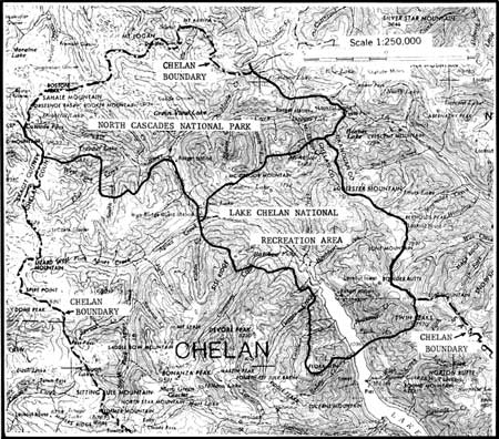
Figure 4-2. Limits of traditional Chelan territory in relation to boundaries
of Lake Chelan National Recreation Area and southeast corner of North Cascades
National Park. The lower part of the lake and the short Columbia River sector
within Chelan country lie beyond the borders of the Park Complex and are not
included in this map. USGS Concrete quadrangle 1955.
Tribal Territory
The traditional territory of the Chelan included a short stretch of the Columbia River on both sides of the mouth of Chelan River, Lake Chelan, and, it must be presumed, the total watershed of the lake. The aboriginal village locational data of Ray (1936:141-142; 1974a:420-423) for the Chelan and for their Methow neighbors on the north and the Entiat on the south define with some precision the extent of the Columbia west bank held by the Chelan. Specifically, their territory extended from the mouth of Antoine Creek, or slightly up the Columbia from that point, downstream past the entrance of Chelan River and as far south as just below the mouth of Navarre Coulee (Smith 1983:166-168). The extent to which the tribe made use of the east side of the Columbia River is much less clear. Still, it is reported (Ray 1974a:423) that they collected roots in the Badger Mountain region, so it is safe to assume that to some degree they exploited the subsistence resources of the east side of the Columbia opposite their west bank country.
The limits of traditional Chelan country west of the Columbia plainly included the entire Lake Chelan area. Consistent with the general tribal land utilization pattern in this section of the Plateau, it may be reasonably concluded that the Chelan claimed as their own all streams -- none, however, of any magnitude -- that drained into Lake Chelan from the Sawtooth Ridge watershed on the northeast and the peaks of the Chelan Mountains on the southwest. On the northwest in aboriginal and early contact times their tribal lands embraced the entire Stehekin River drainage up to the crest of the Cascade Mountains. In terms of the special interests of this present report, these data mean that the entire Lake Chelan National Recreation Area and all of the adjacent southeast corner of the North Cascades National Park fall within the country claimed in traditional times by the Chelan (Figure 4-2).
Cultural Affiliation
As two views of the Chelan in ethnic identify terms ([b] and [c] in above) suggest, the group has been considered by some ethnographers as comprising, in various combinations, a single cultural entity with the Methow upstream and the Entiat and Wenatchi downriver. Thus Teit (1928:89:93) regards these four groups as comprising a single "tribe" essentially uniform in life style, to which he applies, by extension, the term "Wenatchi." He further links this enlarged "Wenatchi tribe" culturally with the Columbia of the western Columbia Basin and adjacent Columbia River Valley, designating this larger, two-component entity the "Middle Columbia Salish."
Even those like Ray (1936:103, 108; 1939:149; 1974a:419-435) who regard the Chelan as a distinct tribal group ([a] above), reflecting the perspective of the Chelan themselves, assume a basic conformity in the traditional lifeways of the Chelan and Wenatchi as well as of the Methow and Entiat. Thus all four groups, though the Entiat are unnamed, make up Ray's "Central Interior Salish" cluster in his 1936 village study. Similarly, all four -- again the Entiat remain unspecified -- are coalesced for descriptive purposes in his 1939 general analysis of cultural relations among the native societies of the Plateau; here, as with Teit, he extends, for the sake of convenience, the more specific term "Wenatchi" to this larger, multi-unit entity. In his 1974 more extended native village catalog of this section of the Columbia Valley, Ray at last distinguishes the Entiat from the Chelan, Methow, Wenatchi proper, and Columbia as a separate "tribal" population. Nevertheless, he continues to recognize a fundamental similarity in the life modes of the first four of these groups, the Columbia being placed in a different cluster with the Southern Okanagan, Sanpoil, and other tribes to the north.
Of these four tribes, ethnographic information is available in some detail only for the Wenatchi.
It is of interest that observers as early as Parker (1842:313) sensed differences in cultural and tribal ethos between the Middle Columbia Salishans on the one hand and both the upriver Salish-speaking groups and the downstream Sahaptians on the other. He writes:
Between Okanagan and the Long Rapids [Priest Rapids] are detachments of Indians, who appear poor, and wanting in that manly and active spirit, which characterizes the tribes . . . [like the Okanagan and Colville upstream]. South of the Long Rapids, to the confluence of Lewis' [Snake] river with the Columbia, are the Yookoomans [Yakima], a more active people.
Evidently the Chelan were included by Parker in this "poor" group cluster. At any rate, his characterization of these Middle Columbia tribes is basically perceptive. Their peaceable and unspectacular life mode stood in contrast to the life ways of the Okanagan, Spokan, and Colville in Parker's day. The Okanagan had had a trading post in their country for 25 years; the Spokan had had one for some 15 years before it was relocated to Colville; and the Colville had had a post for the previous 10 years, to say nothing of possessing their great intertribal salmon fishery at Kettle Falls. And the Middle Columbia life patterns contrasted likewise with the ways of the horse-rich, buffalo-hunting Sahaptians with their post at the mouth of the Walla Walla, their great intertribal rendezvous, their fiercely hostile relations with the Shoshoneans to their south, and their vigorous, exciting life style in general.
Linguistic Affiliation
The Chelan were evidently not only very similar to the Wenatchi culturally, but the two spoke the same Interior Salishan language, though they differed slightly at the dialect level (Teit 1928:93). Together with the Entiat and the Columbia, they comprised the language unit now commonly termed "Columbian" by Plateau linguists (Thompson 1979:693-694). The speech affiliation of the Methow is somewhat less evident. Teit (1928:93), on the basis of his field research among the Columbia in 1908, and later Ray (1932:10), relying on Sanpoil information, place the Methow with the Columbian language tribes, though Teit recognizes some leanings toward the Okanagan language to the north and east. More recently, Kinkade (1967) and Thompson (1979:683-694) regard Methow as an out-and-out Okanagan dialect. Kinkade observes, however, that there is some evidence that Methow at an earlier date was part of the Columbian continuum but for some reason has shifted during fairly recent times toward Okanagan until it became wholly a dialect of the Okanagan language.
The relevance of these data to an attempt to describe -- largely, unfortunately, to reconstruct -- traditional Chelan culture is commented upon below.
Demography
No even roughly reliable head count of the 1811-1850 period exists for the Chelan. This is partly because their population center lay on Lake Chelan, well back from the Columbia River highway, the people of these lake winter villages and summer camps not being really seen until the 1850s. Partly because, as already noted, the Chelan were so frequently lumped with other groups in various ways and combinations; in these cases it is impossible to segregate the Chelan from the whole. Partly because of the inherent problems in making head tallies owing to the high mobility of the population and to variations in village and camp sizes by season and from year to year. And partly because of the effects of new waves of epidemics that passed through the middle Columbia region in the first half of the nineteenth century. For a more detailed discussion of these difficulties see Teit (1928:97-99), Ray (1932:21-22), and Smith (1983:137-138).
How unsatisfactory the earlier data are may be illustrated by the following estimates. According to Gibbs (1855a:417-418), Wilkes in 1841 approximates the "Okinakane" population at 300. If the Chelan -- and the Methow, Entiat, Wenatchi, and perhaps the Columbia also -- are included in his roster, they are presumably buried in this very small 300 estimate: Wilkes may be following Alexander Ross (1966:289-290) who, early in the 1800s, included the Chelan and the other native groups down the Columbia below the Okanogan Valley as far as Priest Rapids with the Okanagan as "tribes" of a single "nation," his "Oakinackens." Warre and Vavasour give a figure of 300 for the "Okanakane, several tribes" in 1849. Again the Chelan and their neighbors as noted above may be incorporated in this population approximation. Dart's data of 1851 give 300 to the Rock Island people (Columbia) and 320 to the "Okinakane" and in 1853 this same field investigator assigns 550 to the "Pisquouse [Wenatchi] and Okinakane" together. The difficulties inherent in sorting out these data in terms of the Chelan and the other tribal units of the Middle Columbia, if they are numbered in any of these figures, are more than obvious.
Similarly, Mooney's (1928:16) data of the early 1900s on this segment of the Columbia River are too confused to be helpful. No mention is made of the Chelan. Presumably they are included with the Methow, who, whatever the case for the Chelan (and Entiat), are explicitly entered in his list with the "Isle de Pierre [Rock Island] (Columbias, Moses' band)." This composite Methow-Columbia unit is estimated to have had a 1780 population of 800 and to have numbered 324 in 1907. Mooney also lists the "Piskwau, etc.," a group embracing not only the "Wenatchi" but also several Sahaptian tribes to their south. It is conceivable, though unlikely, that the Chelan are buried in this Piskwau cluster of linguistically dimorphous tribes, to which he attaches a 1780 figure of 1,400 persons. No separate 1907 census count is given even for this cluster: it is merged with still other tribal groupings before population estimates are presented.
According to Teit's (1928:97-99) Columbia and Wenatchi informants, the Middle Columbia groups were very numerous peoples in precontact times. By the mid-1800s, however, through disease and wars they had become mere remnants of their former size. While there may be some overstatement in these remembrances of former strengths, at least the effects of waves of pestilence, which Teit reports in some detail on informant recollection scourged them four times or more in the first half of the nineteenth century, were without doubt devastating. He concludes that "it may be safe to conjecture that the total population of the [Middle] Columbia group [the Chelan, Columbia, Wenatchi, Entiat, and Methow] at one time was at least about ten thousand." Surely the head-count figures of the preceding paragraph grossly underestimate the demographic strength of the Middle Columbia peoples in aboriginal days and even in the middle 1800s.
In this context it is instructive to note that the population of one Columbia village, that at Rock Island, was estimated by David Thompson (1914:53; Glover 1962:345-346) on July 7,1811, at about 800. This figure was arrived at by pacing off the length and width of the two very long, tule dwellings of the camp, approximating the number of families at about 120 by using these dwelling measurements, and then multiplying this family number by an estimated average family size. In spite of the documented epidemics of the early 1800s, these data for this single 1811 community suggest that Wilkes' 1841 300-person estimate for the "Okinakane" tribe as a whole (if this was Wilkes' intention) was probably too low -- perhaps substantially low -- even for 1841.
For the Chelan proper the only genuinely informative demographic data known to me are the Chelan winter village and summer camp estimates of Ray (1936:141-142; 1974a:419-423) together with the somewhat arbitrary figures that I have assigned to those Chelan population aggregates of Ray for which he provides no head count approximations but only descriptive guides of the "very large," "large," and "small" variety. The premises assumed and methods followed in translating Ray's adjectival estimates into numbers have been described elsewhere (Smith 1983:276-277). Ray's approximations, based on informant inquiry, are for the mid-1800s. It may be taken as a certainty that the Chelan population was somewhat greater in earlier times.
As I compute Ray's demographic data, I arrive at a winter Chelan person count of about 225 in the Columbia Valley villages and 1,185 in those villages occupied around Lake Chelan. The corresponding summer estimates are 230 persons for the river-side camps and 990 for those in the lake area (Smith 1983:278, 280, 318-320). Plainly these numbers, even if for some reason slightly skewed, underscore the lake population focus -- and therefore subsistence resource area emphasis -- of the Chelan.
| SUBSISTENCE |
The subsistence resources of the Chelan included fish, game, and plant foods, apparently in a relatively balanced supply. It is a shame that so little is known about this so basic a segment of Chelan culture and the details of the group's adaptation to its particular bioenvironment.
Fishing
Fish must have provided an important component to the food resources of the Chelan, though certainly a somewhat smaller share than among the Wenatchi. At least in protohistoric and postcontact times, salmon were unable to reach Lake Chelan and its feeders, the tumbling waters of Chelan River -- -"a roaring little stream" Symons (1882:42) calls it -- between the lake and the Columbia being too difficult for them to ascend (Ray 1936:141; 1974a:420). Even on the Columbia the tribe appears to have maintained established villages and camps at only six sites, if the memory of Ray's (1936:141-142; 1974a:419-423) informants can be relied upon. Of this half-dozen, only three are stated to have been occupied in summer. And only one -- that one mile north of Navarre Coulee -- is specifically mentioned as a locality from which fishing was carried out in the Columbia and even this camp had no more than from three to 30 dwellings (Ray 1974a:423).
From these ethnographic data, fragmentary though they are, it is difficult not to conclude that Chelan territory was poor in suitable salmon fishing localities. This conclusion is to some degree supported by the historical records of David Thompson, Alexander Ross, and much later Thomas Symons. When descending the Columbia in early July, 1811, when the water was very high, to explore the river for the North West Company, Thompson (1914:52) mentions only a single rough stretch of fast water in the river course that I define as lying within traditional Chelan boundaries, that about 2 miles, by his estimate, below the mouth of Chelan River. Here on July 6, 1811, he encountered a strong rapid and islands, which, however, caused his canoe no difficulty. Earlier, on July 3 and 4, Thompson (1914:44, 47, 49, 50, 52, 54; Glover 1962 :340-346) had received presents of "2 half dried salmon" and five poor salmon from the Sanpoil, who were taking them at a small weir; on the 5th, gifts of "5 good roasted salmon" and "a good salmon" from the Nespelem; and at an earlier hour on the 6th, when he had observed as he passed and briefly visited a Methow village at the Methow River confluence, a present of "3 roasted salmon." Later, from the Rock Island Columbia, the next people he came upon below the Chelan country, he obtained two salmon. Nevertheless, he makes no mention of seeing a single Indian at the swift water, noted above, in what we know to have been Chelan territory, nor, in fact, in the entire Chelan length of the Columbia.
Why were there on Thompson's passing no Chelan taking salmon and apparently no river camps such as reported as summer settlements ethnographically? Perhaps the water was still running too deep over their main river fishing rapids, for Thompson (1914:48), as already noted, reports that the river was very high. Possibly because the other groups were fishing at the time not in the Columbia itself but on lateral streams (as the Sanpoil certainly were), salmon streams that appear to have been lacking in the Chelan homeland. Whatever the reason, these Thompson data convincingly demonstrate that the Chelan were not at their river fisheries when his small party traveled by and so indirectly argue for the special importance of the Lake Chelan region as a major subsistence resource area for the tribe.
On July 26, 1811, Alexander Ross (1966:139-140) of the Pacific Fur Company, by dint of "a good deal of pulling and hauling," ascended a rapid which he terms "Whitehill rapid." Here he found the river making "several quick bends" and "almost barred across by a ledge of low flat rocks." This difficult stretch was either that which Thompson had passed and reported upon when heading downstream 20 days earlier, or, more probably, that about five miles farther downstream later described by Symons as a boulder and bar rapids. The precise location of Ross' barrier is, in any event, unimportant in this present context, for both possible rapids were within Chelan borders. Ross encamped for the night at the head of this swift water without seeing there a single Indian. The following day, after an early start, he passed about 10 a.m.:
a small but rapid stream, called by the natives Tsill-ane [Chelan], which descended over the rocks in white broken sheets. The Indians told us it took its rise in a lake not far distant.
Not far upriver he met some Indians (presumably Chelan), put ashore, and spent the night. From these friendly natives he secured "some salmon, roots, and berries." On the following day but one, he reached the Methow River, which he calls the "Salmon-fall River," where the Indians presented him with an "abundance of salmon."
As in the Thompson instance, to summarize, no natives were to be seen at the fast water below the Chelan River mouth, but those met above that mouth had some salmon, although, unless we squeeze too much from Ross' brief account, not nearly the rich supply possessed by the Methow.
Seventy years later Symons (1882:39, 42, Figures 13-15), passing down the Columbia in a bateau in early October, 1881, to assess the navigational possibilities of the river, notes nothing but an occasional "little ripple and sand-bar island" between the entrance of the Methow and the confluence of the Chelan River. Below the Chelan River, he passed "an occasional ripple . . . and came soon to some quite strong rapids." These, which he named "Downing's Rapids," are without any doubt those mentioned by Thompson and possibly also by Ross. About seven miles downstream from the mouth of the Chelan, he came upon "a rapid, where the water flows over a bowlder and gravelly bar, on which there was a depth of from seven to eight feet." This location (Symons 1882:map 15) is just downriver from the point, precisely 7 miles below the Chelan River just as Symons estimates, where the Columbia bends sharply to the northwest for about 2 miles (USGS Wenatchee quadrangle 1957). Though not the rapid noted by Thompson on July 6,1811, it may quite possibly be Ross' Whitehill Rapid. Symons evidently observed no Indian settlement at either his Downing's Rapids or this boulder-and-bar rapid and found no Indians fishing at either, although he had camped with the Chelan at their "principal village" 1 mile up the Columbia from the Chelan River entrance and later found several Indians spearing salmon from canoes at the Entiat River mouth slightly farther downstream.
These historical notes suggest, like the ethnographic data, that the Columbia River rapids in Chelan territory did not lend themselves to salmon fishing for some reason, either in the high water of July or in the lower water of early October. And further that there were in Chelan country no tributary streams that offered acceptable salmon fishing possibilities like the Methow and Entiat Rivers. These conclusions are supported by Ray's (1936:141; 1974a:419, 423) informant-derived data that in traditional times the Chelan gathered for salmon at the Entiat fishery, actually a relatively unproductive location, at the entrance of the Entiat River into the Columbia, and at least the people of the large Chelan winter village at the lower end of Lake Chelan journeyed to the Wenatchee River for salmon fishing. Further, after about 1870, members of the tribe were accustomed to fish for salmon at the important Methow fishing location at the Methow River mouth.
To focus these data on the special interests of this study, it appears that an important fraction of the fish in the Chelan diet must have been nonanadromous varieties, fish that were available in the small streams that fed Lake Chelan. Ray (1974a:420-423) lists 13 Chelan habitation sites around the edge of the lake. Of these, 11 were occupied in the summer season. Two of this number are said to have been at the mouth of creeks emptying into the lake, but Ray's data fail to mention fishing as a subsistence activity of these communities. On the other hand, some fish are reported to have been taken by people living at the large village at the lake outlet. These data surely understate the importance of nonanadromous fish taken around the lake shores.
In contrast to the salmon situation among the Chelan, the salmon resources of the Wenatchi were very substantial: in normal years fish were secured in great quantities at localities along the Columbia and even more importantly at sites on the Wenatchee River and certain of its laterals (Ray 1936:142-143; 1974a:424-426; Smith 1983). Indeed, the salmon yield where Icicle Creek flowed into the Wenatchee River was so renowned that the locality became during the season an intertribal fishery (Ray 1974a:425). It is obvious, in short, that salmon must have been of lesser significance to the traditional Chelan than among the Wenatchi, and that nonanadromous fish must have contributed more to the Chelan food supply.
In leaving this salmon issue, a bit of sheer speculation may not be wholly inappropriate. The Chelan area appears to lie in a geologically instable region. The early historical documents report that mild and strong earthquakes were not uncommon. According to Byrd (in Durham 1972:11 fn. 20, 12 fn. 23, 20 fn. 43, 24 fn. 52), Ribbon Bluff (or Cliff) -- along the western side of the Columbia River just downstream from the Chelan River mouth (see Symons 1882:42, map 15) -- was thrown into the river by a quake in December, 1872. This same disturbance produced a huge geyser at Chelan Falls, which, after continuing for "a long time," gradually subsided. Throughout most of 1873 "the whole mountain range between Lake Wenatchee and Lake Chelan was shaken" by almost daily tremors. In 1887 a very early White settler at Entiat recorded "three days of severe earthquake" shocks. In September, 1899, a very large underwater land shift, possibly a large rockfall, produced huge waves on Lake Chelan.
Further, Lake Chelan was subject not only to a normal spring high water owing to the usual seasonal runoff but occasionally to true flooding when precipitation and temperature conditions were right. Thus in 1894 the lake area experienced a huge flood that inter alia
raised the lake level 11 feet over the 1892 low water mark, washing out all the old Stehekin River logjams, . . . changed the course of Fish Creek . . . , washed out and caved in the Chelan River banks below [Chelan] town until it sounded like thunder and felt like earthquakes, [and] rechanneled a fourth of a mile of the mouth of the Chelan River; . . . (Byrd in Durham 1972:2 fn. 6; see also 1 fn. 2 and pp. 7, 8).
It seems theoretically possible that in prehistoric times either major, though local, earthquake activity or massive lake flooding with consequential outlet erosion could have significantly changed the drainage pattern of Lake Chelan. That the lake surface was higher even in late prehistoric days is suggested by the well-known pictographs on the sheer rock wall at the upper end of Lake Chelan, observed by Merriam about 1880 (Symons 1882:40). The highest of these are reported to have been at least 35 feet above the lake level in predam times and to have been reachable only from watercraft when the level was, say, 30 feet higher than in the early historic period (Cain 1950:15; Symons 1882:40; Byrd in Durham 1972:24 fn. 52). If these data are basically accurate, some quite recent -- even in the historical time scale -- shift in the outlet arrangement of the lake must have occurred to lower its southern rim. Earth movements or perhaps even massive flood action (or both) might have produced the barriers in Chelan River that in ethnographic times prevented salmonid ascent to the lake or possibly removed such barriers, allowing anadromous fish navigation to the lake, and later created them again. Or altered the outlet from some other course to today's tortuous, rocky Chelan River canyon. Two possible early outlets would appear to have been Knapp and Navarre Coulees, the first about five miles long and the latter approximately eight miles in length, as compared with Chelan River which today falls the about 375 feet from the lake surface to the Columbia River in only about three miles (Byrd in Durham 1972:7). In this connection it is of interest that in 1892 the sternwheeler Stehekin, cut in two, was hauled by wagon up Navarre Coulee from the Columbia to the lake: obviously this "road" is nothing like the twisting Chelan River canyon with its boulders and falls. And as already noted, the modern highway runs up Knapp Coulee from the Columbia to Lake Chelan. Either of these drainage streams, if such there was, might have been manageable to anadromous fish. A careful examination of the topographic and geological evidence would doubtless test these highly speculative hypotheses, but its seems conceivable that salmonids were able to ascend to Lake Chelan and the Stehekin drainage during some periods in the prehistoric past.
In the absence of specific ethnographic information for the Chelan in regard to fish varieties and fishing techniques, save as noted below, the Wenatchi data are summarized here in keeping with the procedural scheme already explained.
Among the Wenatchi, anadromous fish, especially salmon, of which the Chinook variety was most important, and steelhead trout, comprised staple foods. As already noted, migratory fish were certainly much less important among the Chelan, but of these fish that were taken by this group, either in their own section of the Columbia or at fisheries in the country of neighboring tribes, these two varieties were presumably the most significant. Eels were also taken by the Wenatchi as a food, but whether this was likewise true of the Chelan is not entirely certain. They are said to have been considered inedible among the Flathead, Kutenai, Kalispel, Carrier, Chilcotin, Shuswap, Lillooet, and Klikitat (Ray 1942:104). On the other hand, they were eaten among the Coeur d'Alene, Sanpoil-Nespelem, Southern Okanagan, Thompson, Kittitas, Tenino, Umatilla, and Nez Perce as well as among the Wenatchi (Spinden 1908:206; Post in Spier 1938:18; Ray 1942:104). Inasmuch as these fish were widely eaten in the central and western Plateau, whatever may have been the situation elsewhere in the area, it may be presumed that they were also considered an appropriate food resource among the Chelan, but evidence on the point is lacking.
A catalog of nonanadromous fish caught by the Chelan for food is not available, nor for that matter by the Wenatchi. But, according to Post (in Spier 1938:11-18), the Southern Okanagan, a short distance up the Columbia from the Chelan, supplemented their salmon and steelhead, taken from June until October, with suckers, trout, whitefish, squawfish, lamprey eels, and ling. All of these fish were native to the Columbia Basin region (see Wydoski and Whitney 1979) and so presumably all or most were available to the Chelan in their lake area.
Several different fish are noted in the early historical records as occurring specifically in Lake Chelan and its feeders, including the Stehekin system. These include several varieties of trout: bull trout (Dolly Varden), rainbow trout, and cutthroat trout (Durham 1972:15; Byrd in Durham 1972:12 fn. 25, 15 fn. 26). This list could certainly be extended or at least further documented by a fuller search in the early local records.
Save for Ray's report, mentioned above, that fish were caught by Chelan living in the village at the southern end of the lake, we know nothing ethnographically about fishing localities in the lake sector. Historical accounts of the late nineteenth century, when White settlers were first moving into the region (Byrd in Durham 1972), provide some useful general and specific information.
- Large numbers of rainbow and brook trout were found in numerous streams putting into the lake, Fish Creek being especially notable for its brook type (Durham [1972:15] writing in 1891). (The true brook trout [Salvelinus fontinalis] is an introduced species in Washington [Wydoski and Whitney 1979:47].)
- The best fishing in the lake "at proper stages of the water," according to early White anglers, was where "a rill, a brook or a foaming torrent comes leaping over the cliffs, and is disolved in a mass of spray and foam before it strikes the blue-black waters of the lake" (Durham 1972:12). While these non-native fishermen were using pole, line, and hook -- a technique not particularly favored by Plateau tribes -- these date suggest the possibility of traditional tribal weirs, other types of traps, spear fishing, or still different fishing methods at at least certain of these locations.
- Around the mouths of the creeks where they enter the lake are the feeding grounds for the large lake trout that attain lengths of 2 to 2.5 feet (Lyman [1899:198] writing ca. 1898).
- Large trout were caught in considerable numbers at the very head of the lake where the swift current of Stehekin River flows into the lake (Durham 1972:23).
Mountain streams likewise had their fish. When in 1886, Wm. Sanders and Henry Domke made their difficult way over Sawtooth Ridge from the Methow country to the upper segment of Lake Chelan, they lived much of the time on fish taken in the small streams they encountered, Canoe and Prince among them (Durham 1972:19-20).
Evidently Lake Chelan was natively very rich in fish. In the early 1890s, the hotel at Lakeside on the south shore of the lake near its outlet is reported to have had a standing order for 100 lbs. of fresh fish weekly (Byrd in Durham 1972:15 fn. 27). Moreover, commercial fishermen, quite active on the lake at this time, supplied the Waterville and Coulee City markets with fish (Durham 1972:15).
The methods by which the Chelan took their fish are not described in the literature, but, as a Plateau people and neighbors of the Wenatchi, they presumably, like the Wenatchi, used weirs for both large and small fish. Among the Wenatchi these were constructed by lashing woven fencing against tripods placed straight across the stream. Single weirs were made to slant, the top inclined upstream, and were fitted with a semicircular trap on the upstream side close to the stream bank. Weirs were also built in pairs, the downstream barrier being lower and provided with an opening to allow the fish to pass into the area between the two weirs where a trap of some kind was fashioned. From the trap the fish were removed by being speared from a scaffold adjacent to the weir (Ray 1942:104-106, Figure 66).
The Wenatchi likewise built dams straight across streams to force small fish and eels to concentrate at a low point in the barrier, where a basket trap was placed (Ray 1942:106).
Two types of traps are described for the Wenatchi, both made generally of willow though sometimes of fir. One, surely set in weirs as described above though not so stated by Ray, was of the double funnel variety, either cone-shaped or of truncated cone shape, with a converging stick mouth and a detachable end through which the fish were removed. This was a creek variety of trap (Ray 1942:107; Figures 162, 163). It may be supposed that it was in use among the Chelan no less than by the Wenatchi, and that the Chelan placed them at or close to the mouth of at least some of the small streams that emptied into Lake Chelan.
The second kind of Wenatchi fish trap was an open basket affair, set below falls where salmon, in attempting to ascend the fast water, fell back into the trap (Ray 1942:108). Since salmon, at least in protohistoric and postcontact times, were unable to negotiate the rushing torrent of Chelan River from the Columbia River to Lake Chelan, the Chelan could not have used a trap of this sort for salmon in the lake area. Perhaps, however, they may have placed such a trap on the Chelan River close to its entrance into the Columbia where the migrating fish would have been stopped by a falls, the existence of which is suggested by Alexander Ross' comment of 1811 noted above and by the very small community of Chelan Falls as shown on the USGS Ritzville quadrangle (1953). This assumes that anadromous fish in useful numbers would attempt to swim up a stream from which none could have come as fingerlings. It seems unlikely that the Chelan set basket traps on any of the very few, small streams -- Chelan River possibly aside -- that reach the Columbia in their territory. Ray (1974a:423) describes the summer camp at Navarre Coulee as, inter alia, a fishing settlement, but surely this was at or near a spearing site not a basket-trap-under-a-falls locality.
Among the Wenatchi netting was an important fishing adjunct, used in making both seines and bag nets. It was woven with a boat-shaped, wooden or deer-rib shuttle and a rectangular wooden or rib mesh-spacer, except when the mesh was large enough for the weaver's fingers alone to regular the mesh size (Ray 1942:110).
Wenatchi Indian-hemp seines were of the conical bag sort, fitting with stone sinkers, either encased in hide and attached to the net, or fashioned of a round or oblong stone, grooved either transversally or laterally and tied to the net around this groove. To the end of this bag seine was affixed a fish tail spinner (Ray 1942:109-111).
Dip nets of two varieties were part of the Wenatchi fishing gear. The scoop net, employed in taking salmon, consisted of a circular hoop and an A-frame handle (Ray 1942:109; cf. Figures 294, 295). The vertical-lift net was constructed with a handle of two parallel poles, between which was stretched a small net to warn the fisherman of the arrival of a fish above his net bag (Ray 1942:110; Figure 309).
Hooks, used among the Wenatchi both for salmon and for small fish, were of wood or deer bone and were two-piece, sharp-angled artifacts. They were baited with grasshoppers, crickets, and periwinkles or, when trout were angled for, with fish skin (Ray 1942:110-112; Figure 360).
Single-pronged harpoons were widely used by the Wenatchi. This device consisted of a point, round in cross section, and of a separate two-piece wooden, horn (antler?), or bone butt, to which the point was seized. In the butt was a wedge-shaped socket into which the long shaft was fitted and from which it separated when the point lodged in a fish (Ray 1942:112; see Figure 437). V-shaped or two-pronged spears with points of hardwood firmly fixed to a foreshaft which was, in turn, bound to a shaft were also put to use in fishing (Ray 1942:112-113; Figure 470). Three-pronged spears -- leisters -- were employed in night fishing for small fish and sometimes even for salmon. The side elements were fitted with inside, retrograde barbs of bone or mountain goat horn; the center point was of hardwood or of deer, elk, or bear bone. This unit was lashed to a foreshaft into which the main shaft fitted (Ray 1942:113; Figure 490).
Fish were also shot with three-pronged arrows and sometimes were even caught in the hands from the shore or when wading. Occasionally trout were poisoned (Ray 1942:114). The active ingredient of the poison is not identified by Ray.
To improve a Wenatchi fisherman's chances of success, a shade was constructed on the bank to throw the fishing spot into shadow. Torches were used at night in canoe fishing and fires were sometimes kindled on the beach nearby (Ray 1942:113-114).
In addition to the fishing implements proper, other material culture objects were associated with Wenatchi fishing activities. Woven maple or willow bark baskets served as fish creels. Special rod-shaped clubs were used in dispatching fish; eels, however, were killed by being bitten (Ray 1942:114, 115).
The preparation of salmon among the Wenatchi involved cutting the sides off the fish with an unhafted stone knife and hanging the flesh, spread open with cross-sticks, from a pole to dry. Salmon eggs were dried and stored in salmon skin or hide containers (Ray 1942:134-135).
The first salmon ceremony was celebrated by the Wenatchi only for Chinook salmon. The fish were taken in a regular trap placed in a community weir. In anticipation of the coming salmon, two shamans prayed while watching the weir at night and with the arrival of the fish supervised the ceremony. In a ritual manner, the stomachs were removed and discarded; the heads, tails, and backbones were separated; the backbones were broken, not cut; and the fish were roasted. Finally, the fish were eaten by the chief and the young and old men (Ray 1942:115-116).
Among the Wenatchi, the bones of salmon as a class had to be thrown back into water (Ray 1942:129). River water was ritually drunk as "salmon soup." Eels were cut open under water (Ray 1942:140), which I assume was a ritual requirement rather than a response to some more prosaic and practical consideration.
Freshwater clams were eaten by the Wenatchi, either boiled or cooked in an earth oven. The meat, strung on a circular string or kept on a stick, was dried for later consumption (Ray 1942:135-136).
Hunting
Game contributed importantly to the Wenatchi food supply. Skillful hunters sometimes gained special esteem and to some degree men specialized in hunting particular animals (Ray 1942:123).
Although there are no ethnographic data that address the point head-on, hunting would appear on all available evidence to have been even more significant as a subsistence activity among the Chelan than among the Wenatchi, precisely because fish, especially anadromous types, plainly contributed considerably less to their food resources. To some degree it must have been a year-round Chelan pursuit, both near the lake and especially up in the surrounding mountains. Ray's (1974a:419-423) village/camp catalog for the Chelan (see below) mentions that certain specific settlements were considered excellent spring hunting bases (e.g., village 10) and others especially fine summer hunting centers (e.g., villages 11,12). Even one village-camp location on the Columbia River just north of Navarre Coulee was close to mountains where hunting was good.
Large game included deer as the most important animal to the Wenatchi, but also elk, antelope, mountain goat, bighorn sheep, and brown and grizzly bear (Ray 1942:116-117). For the Chelan more specifically we have the following ethnographic and historical notes regarding the animals native to their territorial ecosystems:
- Natively and still in the early 1890s, "an astounding amount of game" was to be found in the Lake Chelan area. "Grouse, deer, mountain goat, [black] bear, and even cougar were often seen." Grizzly bear and bighorn sheep also lived around the lake. (Durham 1972:18; Byrd in Durham 1972:18 fn. 33, quoting early sources.) A few specifics are recorded in the following paragraphs.
- Beside the Columbia River, several deer were observed by Ross (1966:139) in late August, 1811, at his evening camp located below the Chelan River mouth at the head of the rapids which I provisionally equate with Symons' boulder and bar rapids (see above).
- In the Lake Chelan sector, informant data indicate that some deer were hunted by the Chelan on the unwooded peninsula and in the adjacent shore areas in the vicinity of the Chelan village near the present town of Manson (village 5 in the roster below) (Ray 1974a:421).
- The lake region was evidently marvelous mountain goat country. They are mentioned ethnographically in a way that implies that they comprised a particularly significant resource of the Chelan (Teit 1928:113). The large village at the foot of Lake Chelan (1 in the village-camp roster below) was "an important goat hunting base" (Ray 1936:141). Teit (1928:113,116) reports the Chelan use of goat wool in weaving robes.
- Mountain goats are among the figures represented at the prehistoric pictograph site at the head of Lake Chelan (Cain 1950:15; Durham 1972:24; Byrd in Durham 1972:24 fn. 52; Lyman 1899:195).
- Mountain goats were still so numerous in the early 1890s that
"they seemed inexhaustible" (Byrd in Durham 1972:18 fn. 35). In 1891
Durham (1972:18-19) wrote after a steamer trip up the lake:
Far up the mountain sides are beheld numerous bands of . . . goats [looking] down upon us from their dizzy heights. . . . When the first settlers went upon the lake, one could row all day long without losing sight of large bands. It was no uncommon occurrence to count 100 of these goats in a single band, and large numbers of them were shot from row boats, often falling over the cliffs into the water.
A settler . . . who has taken a place at Fish Creek Point, 50 miles up the lake, killed 50 during this past winter . . . . The meat of the kids is considered a delicacy, but . . . [not so] a piece of salt billy-goat . . .
[Between] the lake and the Methow, . . . they are occasionally seen . . . in bands of 300 and 400.
- On the northeast side of the lake at about the halfway point are two mountains bearing the official names of Little Goat Mountain and Big Goat Mountain (USGS Concrete quadrangle 1955). In the late 1890s, Lyman (1899:198) observed, a great many goats still lived on their crags. From these heights their paths, quite like cattle trails, descended to the lake water.
- Bighorn sheep are confirmed ethnohistorically for Chelan territory by David Thompson's (1914:42; Glover 1962:345) journal entry of July 7,1811: canoeing down the Columbia, he sighted his first bighorn sheep since leaving Kettle Falls, as it looked down upon him from a riverside cliff, when he reached the Beebe sector just upstream from the Chelan River mouth (see Smith 1983:26). Significant or not, he mentions no other sheep downriver while he was still in the Plateau.
- Bighorn sheep appear to be attested to likewise by Ross' (1966:139) observation, on August 26, 1811, of an "ibex, the white musk goat" while nighting at the rapids referred to in the deer item above. Although mountain goat were common in traditional Chelan territory (see above), I regard this sighting as probably that of a sheep, presumably female, rather than a goat, primarily because the latter were typically animals of the lofty. craggy mountains (e.g., Dalquest 1948:407).
- Bighorn sheep are reported to be depicted in the pictographs at the upper end of Lake Chelan referred to in the mountain goat section above (Cain 1950:15; Byrd in Durham 1972:18 fn. 33, 24 fn. 52).
- These native sheep were often mentioned by the very early travelers and settlers in the Lake Chelan region. They must, however, "have been very quickly wiped out" (Byrd in Durham 1972:18 fn. 33, quoting 1892 and 1893 records).
- Bear -- black, I assume -- were taken by the Chelan living in their village near the site of Manson (village 5) (Ray 1974a:421).
- Grizzly bear, according to Byrd (in Durham 1972:18 fn. 33) were "fairly common" in the Lake Chelan region; specimens weighing as much as 800 pounds were not unusual.
- Cougars were to be found back in the mountains (Durham 1972:18). Byrd (in Durham 1972:22) reproduces a photograph of a large animal killed in 1907 in the upper Lake Chelan country.
- Lynx occurred in the Lake Chelan area (Byrd in Durham 1972:27).
Given the hunting patterns of the Plateau in general and of the eastern Cascades tribes in particular, it must be assumed that all of the preceding animals were considered fair game by the Chelan. Caribou and moose are reported to have been absent in traditional times in Wenatchi country (Ray 1942:116). The nonoccurrence of these two animals in the Wenatchee drainage -- as well as in Chelan country -- as native species is confirmed by Dalquest (1948:403, 404).
Rabbits were the most significant of the smaller animals from the Wenatchi point of view; raccoons, beaver, and ground hogs were also hunted to some extent (Ray 1942:117,118, 123,166). For the Chelan explicitly we have only the following ethnographic notes:
- Small game was taken near the outlet of Lake Chelan and near Manson on the lake shore, and muskrats and other small animals were caught at Wapato Lake (Ray 1974a:420-421). It would be surprising if they were not hunted or trapped throughout Chelan country, but the fragmentary ethnographic data fail to so state.
- Marmots were hunted by the Chelan. From their skins robes were fashioned. (Teit 1928:116)
The above few references to game animals in Chelan country are largely random and anecdotal, only secondarily ethnographic. In any case they obviously present a very superficial, incomplete, and sometimes only inferential listing of the native mammalian fauna. It is informative, therefore, to check and extend these observations by comparing them with the zoological assessment of the indigenous mammalian forms of the Chelan homeland to be found in the final Park-use section of this Chelan summary.
Waterfowl -- ducks and sometimes geese -- were taken by the Wenatchi, but apparently played a minor role in the subsistence resources of the tribe (Ray 1942:116-117). Grouse were secured and surely eaten, though the bird is mentioned in the ethnographic literature, to my knowledge, only as a source of feathers used in stuffing pillows (Ray 1942:179). The Chelan use of water and other birds is unknown.
Certain animals and birds were avoided as food by both sexes among the Wenatchi. This list includes the coyote. wolf, mink, and land otter, though foxes were eaten. Among the birds, the buzzard, raven, crow, and eagle were regarded as inedible. Reptiles, frogs, and grasshoppers -- as well as insects in general -- were considered noncomestibles. Children were expected to avoid eating mammal fetuses, fawns, blood, the meat near the kidneys, and deer heads (Ray 1942:130-131).
Among the Wenatchi, animals were hunted both by group methods and by men hunting individually. Group hunts, directed by a leader, included surrounding the game, driving it into natural enclosures, and forcing it through narrow passes where it could be easily shot (Ray 1942:117).
Individual Wenatchi hunters stalked animals with bow and arrow or club, ran game down in brush or, wearing snowshoes, in snow, and drove them into pitfalls. Hibernating bear, skunks, and raccoons were smoked out of their dens. Grizzly bears were killed by thrusting in their open mouth a bone with the two ends sharpened. Beavers were clubbed or snared by their feet. Ground hogs were occasionally hunted with the aid of dogs (Ray 1942:117,118,119,123).
Deadfalls were used for smaller game; pitfalls for larger animals and sometimes also for smaller species.
Deer head disguises were not in use among the Wenatchi, but white fur was employed in some manner (not explained by Ray) to attract mountain goats (Ray 1942:121,122).
Grouse and quail were caught by the Wenatchi with spring pole snares set on logs. Land fowl were shot from blinds and were killed with slings. Eagles were taken from their nest, plucked of the feathers desired, and returned to their nest to be taken again later (Ray 1942:121-122, 123).
We know little about secondary or ancillary hunting procedures followed by the Wenatchi for particular animals. It is reported, however, that in bear hunting, the man dropped dust to test the wind and, when after beaver, the hunter "spoke to" the animal or "called it out" (Ray 1942:123).
In view of the importance of hunting among the Wenatchi, it is not surprising that certain tabus and ritual mandates associated with hunting activities were observed and a number of simple ceremonial practices were followed. Those cited in the ethnographic literature surely represent only a small fraction of the total number, particularly since many must have been observed at no more than the individual hunter, family, or small group level. Further, these cultural prescriptions and proscriptions were without question to a degree dynamic: some old practices disappeared as new ones were developed or borrowed and as rituals practiced by a few gained in favor while others lost their following. But concerning such changes through time among the Wenatchi we know little or nothing. The following are the general tabus, prescriptions, and ceremonial observances listed by Ray (1942:127-130) for the tribe.
A Wenatchi man sweated in his sweat lodge before departing on a hunt and remained continent both before and during the hunt. While the hunt was underway, the activities of his wife were restricted, though in precisely what ways is not described by Ray.
The pursuit of deer, bear, and mountain goat especially called for ritual observances.
(a) Before leaving on a deer hunt, a man was expected to announce his intention and to seek success by securing a lucky piece of some sort from some old man. On the other hand, the animal, once killed, received little special treatment, except that its eyes were broken "to prevent revivification," and the meat was brought into the dwelling through the back. Unlike the practice in other Plateau tribes, the meat could be given away while the game was being brought back to camp, the fresh meat was allowed to touch the ground and to be stepped over, the cooked meat could be taken out of the dwelling, and the heart could be eaten by the hunter (Ray 1942:128-129).
(b) Before departing to hunt the brown bear, the hunter prepared ceremonially by being continent, sweating, and perhaps announcing his hunting plans. While hunting he sang to the bear. After a kill, he sang or talked to the dead animal and wept for it, calling it his brother. At the place of the kill, he removed the eyes and sinew below the tongue, to be given later to an old person, lest the "dead animal ... lick all [the] fat off." The head was eaten by the hunter, who invited friends to join him. Finally the skull was set up, although precisely how and where are not described (Ray 1942:129).
(c) The head of a mountain goat had to be sprinkled with down and cooked by roasting. No one could step over it (Ray 1942:127).
Plant Collecting
Vegetable foods played an important role in the Wenatchi diet. The details, however, are scandalously thin.
Roots were extensively used among the Wenatchi as a food resource, in particular camas and bitterroot. To some extent, wild onions were also dug and eaten. (Ray 1942:131, 137,138, 139)
For the Chelan specifically I have identified the following meager data:
- When on August 27,1811, Alexander Ross (1966:139-140) visited the Chelan group on the Columbia a short distance above the Chelan River entrance, he received from them some roots to eat.
- Root gathering grounds were located on the unforested peninsula and in the adjacent shore areas near the Chelan camp in the Manson sector and apparently on the south side of the lake opposite Green's Landing (camps 5 and 12 in the village/camp inventory). The root collecting country on Badger Mountain east of the Columbia River was visited for roots by the Chelan from the river village near Navarre Coulee. Doubtless there were other root gathering areas in Chelan country. but these are the only ones mentioned by Ray (1974a:421-423) in his Chelan settlement roster.
- Apparently bitterroot was either particularly abundant in Chelan country or of exceptional quality, for one of the Sanpoil-Nespelem terms for the Chelan was "bitterroot people" (Ray 1932:11). This is much as the Kalispel were designated by the Nez Perce "camas people" (Curtis 19118:163) and as the Spokan division of the Little Spokane River were called by other Salishan groups "steelhead trout people" (Ray 1936:122) and the Lakes of the Arrow Lakes region "(a small speckled fish of the lakes) people" (Ray 1936:11).
Digging sticks of the Wenatchi were of serviceberry wood with a cross-wise handle of wood, deer antler, or mountain goat horn (Ray 1942:145).
Because berries contributed importantly to the subsistence base of Plateau peoples in general, it must be assumed that this was equally true of the Wenatchi -- and Chelan -- but, except for the mention of chokecherries, Ray (1942:132, 136, 138, 139, 161) provides no specific Wenatchi data on the fruit gathered and the nature of their use. That they were significant, however, as a food resource is indirectly indicated by the Wenatchi practice of first-fruit ceremonies for berries (Ray 1942:133).
That the Chelan gathered berries as a food resource is clear enough, but beyond this unexceptional fact little relevant information has yet been found in the ethnographic and historical sources.
- In late August, 1811. Ross (1966:139-140) received berries -- as well as salmon and roots -- from the Chelan group, a few miles upstream from the Chelan River confluence, with which he spent the afternoon and night.
- On October 5,1881, while visiting the area at the foot of Lake Chelan, Symons (1882:41) observed an old Indian woman, "who had been to some point up the lake," now returning home with a large basket of elderberries on her head. Unquestionably she was from a Chelan camp in the neighborhood, through Symons saw none where he was at the lake outlet, quite probably because the "beautiful bunch-grass-covered plateau" where the lake narrowed into the Chelan River had been wholly taken over by government troops in the spring of 1880 (Symons 1882:40).
- According to Ray's (1974a:421) Chelan informant, abundantly yielding berry grounds existed in traditional times in the vicinity of Willow Point on the north side of Lake Chelan.
Stems were widely used by the Wenatchi, as was the cambium layer of the lodgepole pine. This "sap" was removed with a deer-rib scraper or one of a curved, slat-like piece of wood and was then cleaned with grass.
Seeds -- specifically those secured from pine cones and sunflowers -- were eaten by the Wenatchi to some extent. The seeds were struck from the plants with beaters made of rawhide on a willow frame. The pits of chokecherries, as well as the pulp itself, and occasionally acorns were likewise consumed. (Ray 1942:131-132, 161)
- In Chelan country sunflowers -- like berries -- grew especially prolifically in the vicinity of Willow Point, giving their name to the year-round village located there (Ray 1974a:421). Ray is not explicit on the matter, yet implies that these plants were a source of food, undoubtedly their seeds. If the plants were, as I suspect, balsamroot (Balsamorhiza sagittata), their roots, young shoots, and bud-stems as well as seeds may well have been eaten as was common among the Indian groups of the southern interior and drier parts of British Columbia (Turner 1978:115-116).
Among the Wenatchi, pine nuts and tree lichen were also a part of the food supply (Ray 1942:137, 138, 139).
Food Preparation and Meal Patterns
Food among the Wenatchi was boiled with hot stones in a woven basket or a dugout wooden vessel, steamed in an earth oven, or roasted on sticks inclined toward the fire (Ray 1942:136-137).
The earth oven was used for bear and deer meat, for wild onions and especially camas, for pine nuts, and for lichen. In this steaming process, a layer of skunk cabbage leaves was placed under the food to be cooked and layers of these same leaves and rye grass were spread above the food. Water was poured inside the pile to generate additional steam and a fire was kindled on top. (Ray 1942:137-138)
Pulverized meat was mixed with camas and with salmon eggs and chokecherries. Animal bones were boiled to make soup. Blood was boiled in tripe with berries and then dried and stored for subsequent eating. (Ray 1942:136, 138, 139)
Sunflower seeds were parched on hot rocks. Whole chokecherries and pine nuts were mascerated. Before being prepared as food, acorns, which as noted above, were not much eaten, were buried in mud to leach them. And certain foods (surely plant foods like seeds) were processed with flat, eliptical basketry sifters. (Ray 1942:136, 137, 139, 161)
Bark baskets were used by the Wenatchi to carry water. Spoons with rounded bowls were fashioned of mountain goat (not bighorn sheep) horn and others, with a short handle, were made of maple or alder. Spatulas of willow wood and clamshell spoons with wooden handles were used as eating utensils. Woven basketry ladles, paddle-shaped food stirrers of wood or an animal rib, basketry dishes and dishes of cedar or alder, and folded cedar-bark bowls also served as cooking and eating implements. Meals were served on mats spread on the ground. Cedar bark was used as napkins. (Ray 1942:140-142,176)
Food Ceremonialism
Consistent with the degree to which vagaries of the weather and more subtle factors affected the availability of game and the abundance of fish and plant foods, the Wenatchi possessed a body of ceremonials designed to soften these influences or even turn them to their advantage.
Rituals were held for the first berries and roots to be harvested during the growing season. Similar rites were carried out for deer, although at what times and under what conditions are not stated. (Ray 1942:133)
Wenatchi ceremonials for plant products are described by Ray (1942:133) as follows, if I understand his synoptic trait list entries. The rite for a particular plant was initiated by the ritual leaders, two or three in number, collecting the edible plant parts when they first appeared in their proper stage of development. These specially gathered materials were prepared and eaten in a feast, the shamans eating first. Before the celebration of this ritual each season, these plant parts were strictly tabued as food (Ray 1942:133-134).
In addition to these seasonal rites, special ceremonial recognition was given to the first animal killed by a boy and the first fish caught by him. Similarly with the first roots gathered by a girl. The ritual was a simple one, consisting of a feast held in the child's home. The food obtained by the child was not eaten by the child but only by older people. (Ray 1942:134)
| TECHNOLOGY |
A number of general manufacturing techniques not associated among the Wenatchi with a single class of objects and also several multipurpose tools and utensils can best be described in this general technology section.
Wood working was accomplished among the Wenatchi with the aid of a number of comparatively specialized tools. Straight wedges, of mountain goat horn with a unilateral bevel or of cherrywood, were used in splitting wood. Both straight chisels and curved ones of horn were in use. Spool-shaped mauls, one-piece elk antler hammers, and elbow adzes consisting of a stone blade attached to a handle fashioned of a natural fork of a tree were other common Wenatchi tools. All-purpose knives of obsidian and carving knives of wood or stone were also among the implements in the Wenatchi kit (Ray 1942:145-147).
Mortars were of wood and were oblong in shape, running either parallel with or across the grain. Stone mortars are reported to have been unknown. On the other hand, pestles, tapered in shape, were of stone, wooden devices to serve this purpose not having been employed by the Wenatchi. (Ray 1942:142-143)
In Wenatchi country, matting was twined with tules as the stiff element. It was also fabricated by sewing rushes together into a single layer surface and providing it with a "willow twined edge." The sewing was accomplished with a curved, 18-inch, hardwood needle with an eye in the distal end. Mats were also woven in a checkerboard pattern. (Ray 1942:160, 163) Matting was fashioned by the Chelan from tules and cattails (Ray 1974a:421).
Cordage was made by the Wenatchi of willow, Indian hemp, animal hair, and sinew. The fibers were first scraped with a bone tool and drawn through a split stick to remove the excess and unwanted material. They were then rolled into cord by the women, using their thighs as the stationary surface. Indian hemp was also braided into cordage. (Ray 1942:161-163)
Coiled, twined, and twilled baskets were woven by the Wenatchi, the first of these types being the most extensively used. Coiled baskets were made on a bundle foundation and were ornamented with imbrication with buffalo grass, bear grass, cedar bark, or cherry bark. The design elements applied to the exterior surface of the basket in the imbrication process were colored with dyes obtained from alder and Oregon grape roots and by placing the elements in mud (Ray 1942:159-160).
Twined baskets, constructed of Indian hemp, included an openwork type and a flexible, round bottom variety. Other twined baskets fashioned of willow strands or rushes were used by the Wenatchi to store articles (and also food?). Details of the twilled baskets are unreported. Cedar split baskets and baskets of rushes were woven in checkerboard patterns. (Ray 1942:160, 161) Among the Chelan, baskets were made of tules and cattails (Ray 1974a:421). Surely other materials were used as well, but these are not mentioned in the casual references in the fragmentary ethnographic literature.
Wenatchi fire drills were of a single piece of wood and were fitted into a hearth consisting of a piece of cottonwood, pine root, or willow root. Fire was also kindled by percussion with a piece of flint. Tongs were made of two pieces of wood, perhaps bound together at the handle end (Ray 1942:143-144).
Weapons
Weapons among the Wenatchi consisted of bows and arrows and of clubs. Spears, daggers, and shields and armor are reported to have been unknown. (Ray 1942:148-154)
Three types of bows were in use: the self bow (the wooden bow alone), the sinew-backed bow (with sinew glued to its back to increase its strength), and the compound bow. The first two types were made of syringa wood taken from the protected side of the tree. They were about 4 feet long, were narrow and eliptical in cross section, and had recurved ends. The grip, sometimes constricted, was wrapped with buckskin. They were provided with a string shock absorber. The compound bow was constructed by splicing together pieces of bighorn sheep horn; concerning this bow variety little is known. The Wenatchi bowstring was of two-ply sinew (Ray 1942:148-149).
Among the Wenatchi, the wooden arrow shaft was straightened with hands and teeth and perhaps sometimes with a perforated wooden straightener used as a wrench. It was polished with sand or with a sandstone abrader, and customarily painted or charred spirally. Its butt end was notched to receive the bow string. The shaft was fletched with three half-feathers from an eagle, placed with the back of each quill against the arrow wood, and fixed in place with a wrapping of pitched sinew. The feathers were trimmed, evenly for short arrows and longer at the butt end for longer shafts. The point varied in material and form depending on the use to which the arrow was to be put. That of the basic hunting arrow was of flint or obsidian; bone and shell heads were unknown. Untipped but sharpened shafts were used for birds and rabbits. Arrows with a blunt or occasionally knobbed head also served as bird arrows. Three-headed arrows were fishing devices. Compound arrows, constructed of two pieces, perhaps of wood and stiff grass though this is not clear, were used in shooting birds and rabbits. (Ray 1942:149-151)
Poison is reported to have been applied to the point for grizzly bears alone (Ray 1942:151). Whether this substance, whatever its nature, was in fact physiologically active or merely magically effective may be questioned.
In shooting, the bow was held diagonally by the Wenatchi and drawn with the "primary release" (Ray 1942:149,151): i.e., the string was pinched between thumb and forefinger, the remaining fingers held free of the string.
The quiver, carried on the back not at the side, was fashioned of an uncut raccoon, coyote, or otter hide or of a cut and sewed bear skin (Ray 1942:151-152).
Wenatchi clubs, their only other weapon, were of stone, apparently unshaped, or of hemlock wood with a knobbed head (Ray 1942:152).
Clothing
The dressing of skins among the Wenatchi was an important women's task. When a hide was to be prepared without the hair, it was first soaked in a pool to loosen the hair and then, placed over a slanting log, was scraped to remove the dark outer layer of skin and the hair. The tool used in this operation was a deer leg bone instrument or a stone scraper fashioned of a piece of schist. The skin was cured with animal brains. Then, stretched over a frame if it were large, it was rubbed with a hafted stone instrument to stretch it. Finally it was hung from a pole over a small fire, its edges weighted down with small stones, and smoked to render it waterproof. Skins were colored with the aid of pulverized roots. Bear, coyote, and wolf skins were tanned by the Wenatchi with their hair left intact (Ray 1942:124-126).
Wenatchi men wore a breechclout and shirt, leggings, a headband and cap, and mittens, in part according to the season.
The breechclout, a year-round item of clothing, was of buckskin or of skin with the fur left intact. The shirt was fashioned of two deer skins, one for the front and one for the back, tied at the sides, and cut so as to provide short sleeves. Leggings, of thigh length, were worn with the fur outside and only in winter. The fur headband is not described; in some manner, however, it symbolized the man's guardian spirit. Coyote or badger caps and caps made of eagle or duck skins were part of the male garb. Mittens, fashioned with the thumb separate from the rest of the hand, were constructed so the fur was worn inside. (Ray 1942:164-168)
Women among the Wenatchi wore a skirt and dress, leggings, and a basketry hat. The skirt, a one-piece garment, was of shredded bark or sagebrush fiber. The dress, a two-buckskin gown as with the men's shirt, had short, unsewed sleeves and was adorned with applique ornamentation. Leggings of buckskin were either of half-knee length or of knee length. Basket hats with a chin strap were fabricated by the wrapped twining technique. (Ray 1942:164-167)
Some items of Wenatchi clothing were worn by both sexes. This was the case with the cape, robe, and moccasins. The cape was of unsquared fur, fastened over the shoulder, or was a square garment woven of shredded bark or occasionally of rushes, fastened around the neck and over the shoulders. The robe consisted of raccoon skins sewed together, of rabbit skins woven together by hand, or of mountain goat wool woven on the fixed loom.
In regard to robes, we have two specific Chelan references. First, the Chelan, most particularly among the Middle Columbia Salish, wore blankets of mountain goat wool. Their special use of this garment is explained by the fact that the tribe "lived near the habitat of the goat." And second, "Marmot robes, woven goat's-wool robes, and woven rabbit-skin robes, were much used by the . . . Chelan" as well as by the Wenatchi. (Teit 1928:113, 116)
The moccasins, worn daily throughout the year, were of one piece with a side seam, fashioned of tanned deer or sometimes bison skin or made of bison skin with the hair left on. They were fitted to the foot with a front drawstring. (Ray 1942:167-168)
Body Care and Ornamentation
Men plucked the hair of the forehead to raise and square-off the hairline. Although sometimes allowing the hair to fall loosely, men generally plaited it into three braids, one in back and one on each side. Women wore only the two side plaits, tying the lower ends with a thong. Both sexes spread bear oil over the hair and, according to Ray, plastered it with white clay, although I would be surprised if this was a daily treatment. The hair was dressed with a hardwood comb. The eyebrows were also plucked to improve their appearance (Ray 1942:169-170).
The sweatbath, described elsewhere, was considered among the Wenatchi as a means for caring for the body properly (Ray 1942:170).
Among the cosmetics in use among the Wenatchi was tallow obtained from deer, mountain goat, and bear. This substance was, in fact, not only employed in this way, but also as a protective covering for the face and body. Whether marrow was likewise applied as a cosmetic is uncertain, for Ray's data are contradictory. At one point he unambiguously states that marrow was extracted by the Wenatchi from animal bones and used as a cosmetic and hair oil (Ray 1942:136) and at another place in this same culture element survey he (Ray 1942:172) indicates that "marrow (buffalo, deer)" was not employed as a cosmetic by the Wenatchi.
Intentional flattening of the forehead was not a Wenatchi practice. according to Ray (1942:171), nor was the nasal septum pierced. On the first of these points, I believe Ray to be correct: the Wenatchi were just to the north of the uprivermost Plateau groups of the Middle Columbia that practiced head deformation -- a lower Columbia Valley trait -- in protohistoric times and even then to a most minor degree. In the case of the septum perforation, on the other hand, the memory of Ray's Wenatchi informants seems faulty. When on July 7,1811, David Thompson (1914:54), the first Euroamerican known to have traveled through the Middle Columbia area, stopped to smoke with the Indians at Rock Island, he reported in his diary entry of that day that "many of these people, like the others, have shells in their noses." For whatever reason, he had not encountered native groups in the Chelan and Wenatchi sectors (Smith 1983), but he had just visited both Sanpoil-Nespelem and Methow Indians on the Columbia upriver (Thompson 1914:44-52). Evidently he was referring to these groups when he wrote "like the others." If these people both above and below the Chelan and Wenatchi wore nasal septum ornaments, it is reasonable to assume that they were likewise a custom among the Chelan and Wenatchi. Apparently this form of adornment lost favor very quickly -- not only in the Wenatchi area but certainly among the Nez Perce (Smith 1985) and Kalispel (Smith 1936-1938) -- after the beginning of the nineteenth centuryand the appearance of the first Whites in the region.
The ear lobe among the Wenatchi was pierced to receive decorative shell pendants. Ornaments also included necklaces and bracelets. The former were of bone beads and just possibly of dentalia and of claws or animal teeth; others of trade beads were also in fashion. Bracelets, worn by women around their wrist, consisted of strings of shells, bent rib bones, and trade beads. (Ray 1942:171-173)
Facial painting was a Wenatchi form of decoration (Ray 1942:172).
| THE SETTLEMENT |
In this section are described the residential and associated structures of the Wenatchi and of the Chelan where data are available, the traditional villages and camps of the Chelan in terms of their location and other details, and the structural components of the customary settlement.
Dwellings and Associated Structures
Wenatchi dwelling types and their furnishings and the ancillary sweat lodge are detailed in the following pages, with notes relating specifically to the Chelan where these exist. Unfortunately, information on other structural forms -- e.g.. food drying racks, caches, menstrual lodges, and ceremonial structures -- that must have stood with the living units in the typical Wenatchi (and Chelan) community is lacking.
Dwellings
The Wenatchi long, winter dwelling, set in a pit about 1 foot deep, was constructed with parallel sides and rounded ends. It varied from about 18 to as much as 80 feet in length and from 14 to 20 feet in width. In cross section it was shaped like an inverted V. the two sides sloping straight fromthe ridge to the ground. The frame consisted of pairs of inclined pole-rafters set into the ground, the tops of each pair crossed and bound to the two ridge poles that ran the length of the structure. Down the sides the rafter pairs were also united by several longitudinal poles, to which they were lashed with willow cordage. This frame was covered with overlapping courses of mats of sewn tules, each mat tied to the poles. Against the outside surface of the lowest mat course, grass was piled to a height of about 3 feet and then covered with earth. The space between the two ridge poles was left open along the entire length of the structure. Directly under it ran a center aisle of bare earth, on each side of which were the living areas with floors covered with rush mats. Along this middle walkway strip were placed the fires, each in a shallow pit; each fire served two families, one on either side of the dwelling. Storage for food and various articles was provided in the rounded ends of the structure; for personal belongings between the walls and rafters; and for firewood alone on the floor. The interior space was entirely without partitions. Entrance to the house was through a door at one end or one at each end, or occasionally one on one side. The bottom of this entrance was raised about 6 inches above the ground; the opening was closed with a hanging tule mat. Immediately inside this doorway was a short aisle, with walls of some sort, leading to an interior door which opened into the dwelling area proper and the end of the center, unmatted walkway. The end storage areas already noted were on the two sides of the end aisle partitions. This structure among the Wenatchi was exclusively a winter shelter: with the end of the cold season, it was generally dismantled and the poles and tule mats were stored until late in the following autumn. (Ray 1942:174-176)
In addition to the long mat lodge, the Wenatchi lived in semisubterranean lodges during the winter season. This dwelling, reported to have been an "old-type" structure, was constructed over a pit about 4 feet deep and 15 to 20 feet in diameter. The roof, conical or pyramidal in form, was framed with radiating poles with a pitch of 20 degrees or more. Over these poles was spread brush and mats and sometimes planks and over these materials a layer of earth. The dwelling entrance was at the side of the roof, sometimes at ground level but generally by way of a tunnel provided with steps. The floor was covered with grass and mats. (Ray 1942:177-178)
This semisubterranean structure was sometimes erected over a square pit, in which case the roof assumed a square shape at the ground level. Otherwise its construction was identical to that of the circular type, including the tunnel entrance. (Ray 1942:177-178)
Chelan use of these winter dwellings is substantially confirmed by Teit (1928:114):
The underground house or semi-underground earth-covered lodge was used by nearly all the Columbia Salish [presumably including the Chelan] in the winter-time, because it was considered warm and very economical of firewood. It seems that they were constructed in the same way as among the Thompson, only the great majority had the entrance on one side, generally the south or sunny side, or the side towards the river or the water. Ascent and descent were by a short ladder or notched log. A few had entrance only through the smoke-hole, and a long ladder like the common kind among the Thompson.
It seems that these were used chiefly in the north among the Wenatchi. This final statement is ambiguous, inasmuch as Teit employs "Wenatchi" both for the Methow, Chelan, Entiat, and Wenatchi as a group and for the Wenatchi proper. Because of his locational qualifier -- "in the north" -- I assume that in this instance the term is used in the broader sense and that the statement applies to -- particularly to -- the Chelan and Methow.
All but one of the traditional Chelan winter villages in the Lake Chelan area listed by Ray (see below) are specifically described as having included semisubterranean dwellings. For the three Chelan villages along the Columbia explicitly designated as winter communities no data regarding house form are recorded; this is, however, probably nothing more than a field inquiry oversight, the bulk of the information on these Columbia River settlements having been collected in the 1930s before the Lake Chelan data were acquired.
As a mobile shelter, the Wenatchi made use of the conical mat lodge. about 14 feet in diameter (Ray 1942:179).
A flat-topped structure with a roof of willow matting served as a temporary shelter (Ray 1942:179). Presumably it was erected at warm weather fishing sites, if we can extrapolate from the pattern among the Sanpoil-Nespelem (Ray 1932:34-35), Southern Okanogan (Post and Commons in Spier 1938:41), and other nearby groups.
Among the Chelan cattails and tules saw service in "house-building" (Ray 1974a:421). Presumably this was at least in the mats used as structure covers and in various ways as interior furnishings, but these details are not reported.
Concerning the objects within the Wenatchi dwellng to take care of daily chores and to make life comfort able, we have only the following scraps of information.
Drying racks were hung the house framework (Ray 1942;180), but whether to dry food, wet objects like clothing, or something still different is not reported.
Pillows were bags. sometimes of buckskin, filled with grass or grouse feathers, Blankets were made of mountain goat wool, rolled into cordage on the thigh, and woved with a spindle on a simple fixed loom. Other blankets were fashioned of strips of rabbit skin, but the fabrication process is not described. (Ray 1942:163-164, 179)
Sweat Lodge
The Wenatchi sweat lodge was of the "Plains type." A frame of willow branches, hemispherical in shape, was constructed over a circular pit about 1 foot deep. This frame was covered with mats or grass and then completely with earth. A square entrance and closed with a hanging mat. The floor was grass-covered except for a round pit to receive the hot rocks, when the lodge was in use, at the right side of the entrance or in the center in large lodges. Outside was the fire pit in which the rocks were heated.
The lodge was occupied by one person at a time, Ray reports. Still, it seems that this cannot have been invariably true, for, as stated above, there were larger lodges among the Wenatchi -- those with the fire rock pit in their center -- which must surely have been used by more than one person at the same time. In use, water was thrown on the rocks to generate the hot steam. While sweating, a person prayed to the sweat lodge, addressing it as "grandfather" and regarding it sometimes as a deity, and sang his sweat house songs. One could sweat at any time during the day, but invariably visited the lodge before hunting or gambling. A period of sweating was always followed by a cold plunge, for which reason the lodge was always located near fresh water.
Women never used the men's sweat lodges, but had their own structures built identically to those of the men.
All sweating structures were owned by the entire camp or village and were communally used for curing and purification, as well as a means of maintaining body cleanliness. (Ray 1942:170,180-182)
Mud baths of some sort were also used by the Wenatchi (Ray 1942:182).
Parturition and Menstrual Shelters
In both summer and winter, Wenatchi women gave birth in structures erected for this specific purpose (Ray 1942:193). Though not described in the ethnographic literature, they were presumably shelters of some sort, located in a semi-secluded area close to the village or camp.
A special hut was also constructed away from the community for a girl at the time of her first menses. Menstrual structures were also sometimes used during subsequent periods in preference to seclusion within the family dwelling. (Ray 1942 :202, 206)
Residential and Task Sites
(omitted from the on-line edition)
Village and Camp Arrangement
Little is known concerning the typical physical arrangement of the Wenatchi village and camp and the spatial positioning of their structural components. The ethnographic data reveal only that the long, mat-covered winter dwellings were constructed in a line with one end of each house facing the prevailing wind. And that special birthing and menstrual shelters were positioned in secluded areas outside but near the villages and camps. (Ray 1942:176, 193, 202, 206).
Relevant information is wholly lacking for the Chelan.
Domestic and Tamed Animals
Domestic animals were limited among the Wenatchi to native dogs, which were numerous. They are said to have been large and to have had heavy hair. Beyond the fact that they were named and were sometimes used in hunting ground hogs, we know little about how they were cared for and used. They were not eaten, as, in fact, they were not so far as is known among any tribes of the American Columbian Plateau. (Ray 1942:123-124)
Horses reached the Wenatchi about the middle of the eighteenth century or possibly a trifle earlier (Haines 1938:430). Two localities in Chelan territory are reported, on informant testimony, as having been horse grazing areas: one at the large village near the outlet of Lake Chelan and the other at Wapato Point on the north shore of the lake near the town of Manson (villages 1 and 5 in my Chelan village/camp listing; see above) (Ray 1974a:421). The first of Ray's two localities is evidently that described by Symons (1882:40): "... just where the lake [Chelan] narrows into the creek [Chelan River] . . . [is] a beautiful bunch-grass-covered plateau on the north bank, stretching back about a mile to the rocky and timbered hills." It was on this surface, as reported above, that the military constructed Camp Chelan in 1880.
Certain of the wild animals of the Wenatchi area were sometimes kept as pets. Specifically reported are bears while young, raccoons, and birds, these last kept inside the dwelling. (Ray 1942:124)
Residental and Task Sites
A roster of traditional Chelan villages and camps was secured from native informants by Ray (1974a:420-423), apparently in the late 1940s. This supplements and greatly extends the brief list obtained by him in the early 1930s (Ray 1936:141-142). In the mid-1800s George Gibbs (1860) compiled a limited settlement inventory, unfortunately not available to me. From this register, however, Ray extracts a few ethnographic data to add to his own field settlement records.
To my knowledge, no integrated descriptions of the various biogeoclimatic features considered desirable by the Chelan in selecting their winter village and summer camp sites -- as opposed to their short occupancy task-oriented sites -- is to be found in the ethnographic literature. Nevertheless, from the rather casual and certainly incomplete comments of Ray's informants concerning the merits and disadvantages of certain of the residential localities listed in his roster, it is possible to arrive at some of these features. How they would have been ranked by the Chelan in terms of their individual importance is, unfortunately, uncertain.
(a) Criteria for winter villages:
- A level surface.
- A south-facing exposure for warmth.
- Pretection from cold winds that blew up the lake in winter.
- An open point or headland. (This appears to be in some conflict with the preceding.)
- A nearby beach that collected large amounts of driftwood which "originated in the heavily wooded areas up the lake." From these sources came firewood without having to cut it up and carry it far.
- Grazing areas for horses.
- Early snow melting in the spring, allowing favorable spring hunting to replenish food stores depleted during the winter.
(b) Criteria for summer camps:
- Nearby hunting areas for large game and small animals.
- Fishing sites in the vicinity.
- Productive root grounds, berry patches, and sunflower areas nearby.
- Nearby sources of various technological materials: e.g., cattails and tules for baskets, matting. etc.
- Large open meadows where horses could graze and athletic contests could take place.
In the list reproduced below, Chelan villages and camps on the Columbia River are excluded as probably too distant from the Park Complex and too oriented toward the river and its vicinity to be of material relevance.
However, the 13 settlements known to Ray to have been situated on the Lake Chelan shores are all included and their data summarized in the list below. It is reasonable to suggest that people from all of these made use to a greater or lesser extent of the subsistence and other resources of the upper end of the lake and its bordering mountains, the area within the limits of Lake Chelan National Recreation Area. In fact, even the most distant of these villages -- that at the foot of the lake (1 below) -- was no more than about 46 lake miles from where the Park line now crosses the lake.
Ray (1974a:419) refers to a map on which he locates these settlement sites in his Indian Claims Commission document; unfortunately this map was not printed in 1974 with his descriptive report. Further, only one Lake Chelan village is located on his earlier native villages and groupings map (Ray 1936:119 Figure 5); this is the first village in the list below. I have attempted, however, to place Ray's camps and villages as accurately as possible from his locational data (Figure 4-3).
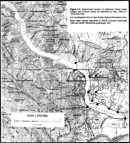
Figure 4-3. Approximate location of traditional Chelan winter villages
and summer camps as described by Ray (1936:141, 1974a:420-423).
A-A: southeastern limit of Lake Chelan National Recreation Area.
Base maps: spliced segments of USGS Concrete quadrangle 1955 and
USGS Wenatchee quadrangle 1957.
It should be noted that the locations provided by Ray in terms of highways, town sites, and other cultural features of Western life are as of the 1950s, when Ray conducted his village field research among the Chelan. And further, that by "summer settlement" or "summer camp" in the following camp and village series I mean a population group that occupied a particular site during the summer or, by extension, some other part or even allof the warmer seasons.
The 13 ethnographically reported Lake Chelan communities are the following. Further details regarding some of them can be found in Ray's (1936:141-142; 1974a:420-423) roster.
1. yenmusi'tsa
(a) At lower end of Lake Chelan. Shown on Ray's (1936:119 Figure 5) site map to have been located on the lake shore just south of the outlet through Chelan River.
(b) winter village: one of the largest of the Chelan with many semisubterranean dwellings. Population c. 100 persons.
(c) Summer camp: larger population than in winter; a popular sports area because of large and open meadows.
(d) Horses were pastured in vicinity. Some fish -- but no salmon -- and smaller game were taken here. An important mountain goat hunting base according to Ray's (1936:141) early data, a fact, however, not repeated in his 1974 summary.
2. ?
(a) On open point extending out into lake, 3/10 mile NW of junction of highway 10C, on N side of Lake Chelan, and Gold Creek road.
(b) Small winter village consisting of a few semisubterranean dwellings.
3. stcho'pas (Gibbs' name)
(a) On open headland on N side of Lake Chelan, 7/10 mile NW of junction of highway 10C and Gold Creek road. Gibbs appears to list this same village.
(b) Large winter village with many semisubterranean dwellings, the remains of which were largely under water in late 1940s owing to elevation of lake level in 1928. Population c. 100 persons.
(c) Large summer camp. Ray implies population about same as in winter.
4. ?
(a) On N side of Lake Chelan at lower end of town of Manson.
(b) Small winter village of three or four semisubterranean dwellings.
5. qe'se'm
(a) On neck of peninsula known as Wapato Point, adjacent to town of Manson.
(b) Winter village of dozens of underground dwellings, some quite large. Population was considerable. Well protected from cold winds which blew up the lake in winter and well provided with beach driftwood for firewood.
(c) Summer camp.
(d) Nearby grazing areas for horses, small root grounds, and a hunting area for small game and some deer and bear.
6. naqwa'st, "deep lake"
(a) At Wapato Lake on NE side of Lake Chelan.
(c) Summer settlement of c. 50 persons.
(d) Tules and cattails profuse, gathered for basketry, matting, and dwelling-building. Muskrats were trap ped and other small game taken.
7. pi'pi'ku'lu
(a) On Willow Point on N side of lake.
(b) Very large winter village with many semisubterranean dwellings. Population probably reached c. 500 persons.
(c) Very large summer settlement.
(d) Advantages similar to those of village 5 above. Also sunflowers and berries grew profusely nearby.
8. qatqa't
(a) At Dry Lakes NW of Willow Point.
(c) Small summer settlement averaging c. 40 people.
9. qwatca'n
(a) At Green's Landing on N side of Lake Chelan.
(b) Winter village with semisubterranean dwellings. Population c. 60 to 80 persons.
(c) Summer settlement.
10. loqtci'n
(a) Mouth of Grade Creek, N side of Lake Chelan.
(c) Several dwellings occupied through spring, summer, and autumn; average population c. 40-60 persons.
(d) A popular location for spring hunting since the snow melted early here and driftwood was abundant. The small area of level land occupied by the settlement was all underwater in the later 1940s.
11. squatnali'lu (=Gibbs' "skwutnatliilwhu")
(a) At mouth of Twentyfive Mile Creek, S side of Lake Chelan, the largest stream flowing into lower half of lake on either side. Gibbs mistakenly locates this camp on N side of lake.
(c) Summer settlement with varying population.
(d) Base for excellent hunting in adjacent mountains.
12. loq*e'nq (* indicates a handwritten phonetic character that I cannot read)
(a) Below a granite slide on S side of Lake Chelan, opposite Green's Landing.
(c) Small summer hunting and gathering camp.
13. ?
(a) At mouth of First Creek on Indian Point, a peninsula occupied by a state park.
(b) Only winter village on S side of Lake Chelan, this north slope being generally too cold in winter. Population c. 50 persons.
(c) Summer settlement. Population c. 50 people.
To the above settlement roster may be appended a few notes of particular interest:
- In 1880 the military established its Camp Chelan on the lake shore "just where the lake narrows into the creek [Chelan River], on a beautiful bunch-grass-covered plateau on the north bank." Though dwellings, a sawmill, and other facilities were constructed there, the post was abandoned prior to October of 1881, an action taken primarily because of the "terrible road getting down to the [Columbia] river from the Great Plain on the east, . . . ; the crossing of the [Columbia] river where there was quite a swift current; and the ascent of the hill to the lake. (Symons 1882:40; see also Byrd in Durham 1972:1 fn. 4, 3, 5 fn. 10,17). In 1899 the Chelan townsite was laid out where the Camp had been located (Byrd in Durham 1972:1 fn. 4). It would be of interest to discover why the Chelan chose the south side of the outlet for their winter quarters (village 1 above), assuming that Ray has it correctly plotted, not the north side selected by the first Whites for their settlements.
- When, prior to 1886, the Indians were given an opportunity to
secure allotments of one section each on the lake, thirteen families --
called Wapato Indians in the early literature from Joe (or Jack) Wapato,
their headman -- they chose to settle in the area described by Durham
(1972:9) thus:
Ten or 12 miles from its mouth the lake boldly bends to the north, and laying in the elbow thus encircled upon the north shore of the lake, and extending from a point nearly opposite Chelan to the shore of the lake after it bends northward, lies the extensive lands of the Wapato Indians, . . . [T]hey have managed to acquire the cream of the lands upon the north shore of the lake."
Evidently this area included the sites of the aboriginal villages 2-5 and perhaps 6 in the preceding listing. Durham's envious characterization of the qualities of this piece of land tells us something about the Chelan selection of village locations. So also does the fact that, if village 1 (just outside the area described by Durham) and camp 6 are included in the tabulation, then about one-half of the ethnographically reported, aboriginal Chelan settlements on the lake were located on this small segment of the lake borders and approximately one-half of the Chelan population at the lake occupied these communities (Smith 1983:320).
These allotment Indians appear to have been of mixed Chelan and Entiat affiliation. At least Byrd (in Durham 1972:9 fn. 19, 10, 11 fns. 20 and 21) describes these thirteen families as a "group of Okanogan Indians . . . [and] a more or less separate settled faming branch of the Chelan-Entiat Indians." And he adds that Joe Wapato, the chief of this "Chelan (Entiat) branch of the Okanogan Indians," was born "in the Entiat Valley" about 1826.
- Some of the properties of the area at the entrance of First Creek that made it suitable for Chelan village and camp location 13 are suggested by the fact that on the low bench by the creek mouth J. W. Stevenson, from Ohio, settled about 1888. By 1892 he had a thriving farm of 160 acres, irrigated from the creek, in fine vegetables and fruit trees. (Brett in Stone 1983:62)
From these settlement data it is apparent that, so far as the informants of Ray (and evidently of Gibbs also) were concerned, no Chelan winter villages or even summer camps of any extended use were located on the shores of Lake Chelan above the winter villages on Grade Creek on the north side (village 10 above) and on Twentyfive Mile Creek on the south side (village 11 above). Thus the nearest ethnographically established communities to the southern limits of the Lake Chelan National Recreation Area were about 28 miles down the lake. From this point downward to the lake foot, especially along the north shore, winter and summer settlements clustered rather thickly.
Settlement population estimates are, of course, nothing more than memory approximations, doubtless more important for suggesting the relative size of communities than their actual average occupant numbers. But working with these rough figures, we find that the population of the winter villages totals about 1,185 persons. Thus in the third quarter of the nineteenth century a substantial number of Chelan considered the Lake Chelan region their homeland, perhaps five times as many as wintered along the Columbia River (Smith1983:319-320).
In contrast to the winter population of approximately 1,185 people, the "summer" population around the lake shores during the 1850 period computes, from Ray's (1974a:420-423) individual community estimates, to about 990 persons. Assuming that a difference of this magnitude is fundamentally real, what happened to the Lake Chelan village folk when then snow left the ground and the country opened up? As noted in the subsistence section above, they surely scattered into the hills around the lake -- presumably to some extent even its upper regions -- to hunt game and secure early roots and other seasonal vegetable resources. In summer, some clearly occupied the summer camps reported in the above roster. But others (like some from the village of yenmusi'tsa [1 above] to which Ray [1936:141] makes specific reference) went down to the Columbia to fish for salmon; yet not many could have moved in this direction -- unless there was largely countervailing movement of river folk up to the lake -- for the summer population of the Chelan settlements on the Columbia seems to have been only about 230 persons, about five more than in the winter villages. Still others presumably continued in small groups to utilize the stream and mountain subsistence resources of the lake slopes away from the established summer communities, not excluding the resources far up the lake. Fall evidently saw the same kind of population dispersion that characterized the spring season, then to exploit the food sources available at that period.
In short, though the evidence is largely circumstantial, resting on relevant comparative ethnographic data for better-known nearby Plateau tribes, it appears that, at least during the last 150 years, the Park region was unoccupied by Chelan in winter but surely was utilized to some unknown extent as subsistence grounds during the warmer seasons. Quite possibly, if appropriate sites exist along the lake shores above Grade and Twenty five Mile Creeks, winter villages were maintained at some of these localities in earlier times and an even greater exploitation of the food and other resources of the upper lake flanks occurred. For it can hardly be doubted that the Chelan population in, say, 1850 was smaller by some significant measure than in the precontact and perhaps even early postcontact times. The terrible epidemics of smallpox and other Western diseases that are widely reported in the early historic documents of the Northwest (beginning with the journals of Lewis and Clark [e.g., Thwaites 1969 4:241]) and in the ethnographic studies of the Plateau and contiguous regions (see, e.g., Teit 1928:97-98; Ray 1932:21-22; Walters in Spier 1938:73-74) attest to their devastating effects on the native groups of the area.
Whatever the case for winter villages, there were certainly a number of localities along the lake, even at and near the upper end where the rocky cliffs generally rise steeply from then lake side, where temporary, warmer season camps could be made. About 1890 Isaac Tillinghast (in Stone 1983:50-51, 54-57) reported that outdoorsmen were then accustomed to take the steamer from the foot of Lake Chelan to the lake head, with their boats towed behind, and then rowed "their way back, about ten miles per day, camping along the shore, usually at the mouth of some one of the numerous creeks which are frequently found coming down from the mountains." He himself encamped for several days at the mouth of Fish Creek, living on deer and grouse killed in the area and on large trout taken in the lake. This must have been in the immediate vicinity of where J. R. Moore settled in 1989 or 1890 on what came to be known as Moore's Point (Byrd in Durham 1972:13, 18 fn. 34; see community of "Moore" on USGS Concrete quadrangle 1955). In then late 1890s Lyman (1899:198) stated that Railroad Creek was then one of the finest locations on the lake for hunting, fishing, and camping. If in his day Whites pitched camp in the immediate creek vicinity and found game and fish resources nearby, it can be considered a certainty that the traditional Chelan had done likewise.
| TRAVEL, TRANSPORTATION, & INTERTRIBAL RELATIONS |
In fully traditional times goods in Wenatchi territory were transported on foot or with the aid of canoes.
Objects were carried in squares of deerskin or matting, in conical rawhide bags with wooden hoops, and possibly lashed to a snowshoe as a pack frame. When burdens were borne on the back, packstraps were put to use. Some were of buckskin with a fur headpiece and others were twined of small tules or Indian hemp. These straps were worn around the head or the chest depending on the circumstance, and were used by both men and women. (Ray 1942:147-148)
The Wenatchi canoe was a pine or cedar dugout, a watercraft extensively used by the tribe; the bark canoe was not in use. The tree from which the craft was to be fashioned was felled by burning and then hollowed out by burning with hot rocks and chiseling. The shape of the canoe is not described. Within the tribe some men were specialist canoe makers who sold the products of their labors. The canoe was propelled by paddles and poles. Paddles were fashioned of a single piece of cedar and shaped with a long handle with a plain, unenlarged butt and a pointed blade. They were sometimes oiled and occasionally charred. Where circumstances dictated, the canoe was pushed ahead with a small fir pole with a charred point. Canoes were rid of unwanted water with a paddle or with a flat, coiled basket or haftedalder bark bailer. Stones answered the purpose of an anchor. (Ray 1942:154-158)
Dugout canoes were also a Chelan watercraft to judge from what is known of their distribution in the central western Plateau -- among the Klikitat, Tenino, Umatilla, Kittitas, Wenatchi, Southern Okanagan, and Sanpoil-Nespelem (Teit 1928:120; Ray 1936:118-119; 1942:154; Post and Commons in Spier 1938:56) -- and from the following data fragment.
- In the summer of 1879 Symons (1882:39-40) was paddled up Lake Chelan by the old Chelan chief and his son, who, I gather, were then living at the principal village of the tribe, situated on the Columbia River about one mile upstream from the Chelan River mouth. The trip, which took him up the lake for a distance of about 24 miles, was made in a Chelan dugout canoe.
Evidently canoes were of limited winter use on Lake Chelan -- at least in some winters and in some sections of the lake. In a discussion of early dam-building efforts in the area, it is incidentally observed that in January, 1893, "the lake ... [was] frozen over a foot thick above Wapato Point for six miles for over a month" (Byrd in Durham 1972:2 fn. 6).
Rafts of logs lashed together with willow bindings were used by the Wenatchi on lakes (Ray 1942:156).
Wenatchi snowshoes consisted of a maple frame bent into what is described as a "comet shape." The netting, woven with a loop mesh, was of willow withe, Indian hemp, or deer rawhide. Oval shaped snowshoes were used only by children. Toboggans were employed in winter for hauling loads. (Ray 1942:158-159)
Trails
Markings of some sort were placed by the Wenatchi along trails (Ray 1942:190), presumably to identify the route, although this is not explicitly stated. Possibly some signs were intended to convey to following groups immediately relevant, specific information: e.g., the direction taken, the presence of friends nearby, the location of meat hung-up closeby for their use, the occurrence of a recent death, or some such news. Such marks were widely used in the Plateau.
Trails between the Chelan country and the territories of their neighbors are on occasion alluded to in the ethnographic and historical literature, but usually only in terms so general that their courses cannot be followed in detail. Barring those that led from the left bank of the Columbia more or less eastward into the Basin area -- like that or those to Badger Mountain -- four principal trail patterns out of the Chelan homeland can be discerned.
(1) A trail ran from the Chelan River mouth north along the west side of the Columbia to the Methow Valley and south following the Columbia to the Entiat and Wenatchi countries.
- This was the path followed by Alexander Ross (1956:21-31) on horseback in April, 1814, en route from the confluence of the Okanogan to the Kittitas area of the upper Yakima Valley. He returned northward by this same route. (See ethnohistorical section above.)
- In April, 1827, Edward Ermatinger (1912:74), in a Hudson's Bay brigade, passed up the Columbia River (see earlier section). The group's single boat was inadequate to transport the full party. forcing some members to walk along the Columbia riverside. On the fourth, they trekked upstream to the brigade's evening camp "a league" above the Chelan River confluence, finding during the day "a good deal of snow on the hills." The following day these walkers continued up the trail to Fort Okanagan. Assuming the camp of the fourth was on the west side of the Columbia as Ermatinger's Chelan River statement implies, the foot travelers surely proceeded up this right bank trail. In any event, they certainly walked through the entire Chelan country along a river path.
- The northern segment of this trail, from just upstream from the Chelan River entrance, was traveled, also on horseback, by John Work in August, 1828 (see above).
- It was likewise the route taken in late September of 1853 by the McClellan party of the Stevens (1855) railroad survey, when it rode up the Columbia from the Wenatchee country to the Okanogan. This group, however, leaving the riverbank route, ascended what I believe to have been Knapp Coulee to Lake Chelan and then, after following the lake shore for a short distance, passed in a generally easterly or northeasterly direction back to the Columbia Valley.
The most detailed early descriptions of this riverside trail are provided by George McClellan (in Stevens 1855:196) and two of his staff, J. K. Duncan (in Stevens 1855:212-213) and especially J. F. Minter (in Stevens 1855:382-383), when they followed the Columbia northward in 1853, as noted in the preceding paragraph. Coalescing these three accounts and deriving rough topographic details from the 1881 field sketch map of Symons (1882:map 14) and the USGS Wenatchee (1957) and USGS Ritzville (1853) quadrangles for the trail segments immediately above and below the Chelan River mouth, around which the survey team detoured, one emerges with the following picture.
- Upstream from the Chelan River confluence, the trail led along a level terrace, climbed to a very high, bunch-grass plateau, and then descended by a steep sandy slope to the Columbia bottom, which it followed for about eight miles to the Methow River. Evidently there were no notable trail hindrances on this route.
- The trail to the south was substantially more troublesome. For
much of the distance from the Chelan mouth to Knapp Coulee, the maps
suggest, it hugged the river with precipitous cliffs on the right. From
the mouth of a ravine which I equate with Knapp Coulee, however, the
McClellan party provides topographic details, which I summarize in
reverse order, since these travelers came up the Columbia. From this
coulee to the Entiat River the trial ran along relatively level
terraces, at times very close to the water and now and again interrupted
by mountain spurs, where the path became very narrow, tortuous and
dangerous. One of these spurs was just downstream from the coulee; the
other, a particularly threatening elevated mass where the party lost
four mules, two killed and two seriously injured, was about three miles
above the confluence of the Entiat River. From the Entiat to the
Wenatchee, the trail was again generally on a level terrace, broken by
occasional rocky spurs, one near the Wenatchee River being especially
hazardous.
To how great an extent this north-south riverbank trail was used by the Chelan in prehorse days when heading upriver to visit Methow and Southern Okanogan and when journeying southward to the Entiat and Wenatchi country is unknown: parties may well have gone largely by canoe particularly when heading southward, in preference to undertaking the trip on foot. It may be presumed that at least after the horse was acquired, this land trail saw more extensive use.
Similarly, how often this riverside route was followed in preequine times by groups to the north of the Chelan -- again primarily the Methow and Southern Okanagan -- when descending the Columbia to the Chelan River and perhaps also the lower Lake Chelan areas or when passing through the Chelan sector to the Entiat and Wenatchi regions downriver is unclear. The same may be said of the Entiat and Wenatchi when heading north on the river bank. For what it is worth, however, we are told that long ago the Middle Columbia Salish had few canoes (Teit 1928:120) and the same for the Southern Okanagan (Post and Commons in Spier 1938:56). Whether this represents a reduction in canoe use following the appearance of the horse or is equally descriptive of the preequine period is not certain. But if approximately correct, it can only signify that much of what north-south movement occurred along the Columbia was by foot. To the degree that these journeys involved the Chelan territory, this river bank trail must have been the one followed.
(2) At least one and probably more trails led northeasterly from Lake Chelan across the Methow Mountains to the upper and middle Methow Valley.
- One of these old Indian trails was followed -- or attempted to be followed -- by Alexander Ross (1956:36-42) in August, 1814, when making his futile attempt to discover a route from the Okanogan Valley to Puget Sound. As mentioned above, his path was so winding and difficult that, in spite of his efforts to describe it in detail, it cannot be traced with certainty after leaving the lower Methow River line. Most who have tried to identify his path, it appears, have him ascending the Twisp River, crossing the watershed via Twisp Pass, and so, with great travail, reaching the upper Stehekin region. While his Okanagan guide described the route as that used frequently in the past by Okanagan in traveling to the Skagit country, he was plainly not familiar with its precise course. There is also the suggestion that in recent years it had fallen into disuse and so had already become in Ross' day poorly marked, assisting his guide in going astray.
- In late September and early October, 1853, McClellan (in Stevens
1855:197), Minter (in Stevens 1855:383-384), and others in a party left
Fort Okanagan to explore a possible Methow River railroad route, having
been informed by the fort personnel that "there was a good foot trail
leading up ... [the Methow] valley and over to the sound." No mention is
made of guides, although it appears that they must have had some Indian
assistance. According to the McClellan-Minter accounts, the party went
over very high hills, first sandy and bunch-grass covered and then pine
forested, to the Methow at a point about four miles below the Twisp
mouth. It ascended this short section of the Methow and turned up the
Twisp for about 11.5 miles to a point where "the stream forked, the
north fork rising a few miles farther on in a high, bare ridge of
granitic mountains; the south fork, Nahai-el-ix-on, coming down a narrow
and precipitous ravine." Riding up this ravine, the party discovered
that the route soon became impassable for animals, forcing it to proceed
on foot, an effort that was soon abandoned. "The trail," McClellan
remarks, "is said to pass from this ravine, over a very difficult
country, to the stream emptying into the head of Lake Chelan, then to
cross very steep and lofty mountains at the head of the stream, and
finally to reach the Skagitt river on the western slope." In view of
this remark, which has the appearance of being guide-derived, it is a
shame that I cannot yet identify the "Nahai-el-ix-on."
For this ravine side stream there seem to be two plausible identifications:
(a) Minter underestimated his distance of 11.5 miles and his party actually ascended the Twisp some 14 miles to the mouth of War Creek and then proceeded up that stream, as Pierce appears to have 30 years later (see next item). McClellan's statement that the Nahai-el-ix-on gave access to the river [surely the Stehekin] at the upper end of Lake Chelan and with the mountain pass at its head suggests a lateral creek at least as far up the Twisp as War Creek. That this Nahai-el-ix-on or South Fork was, in fact, War Creek -- a possibility occurring to me on the basis of a close reading of McClellan's field record -- seems to be accepted by Beckey (1981:280 fn. 25) as an established fact. McClellan appears to have found his cross-montane trail more difficult in its lowest reaches than Pierce later did his War Creek transit. Perhaps during the intervening three decades the route improved to some degree. On the other hand, McClellan was obviously one who went up into the mountains reluctantly, remained there the shortest time possible, avoided snow at every opportunity, and in general magnified the difficulties of his travel (cf. Overmeyer 1941:36 fn. 129, 57, 59, 60).
(b) McClellan misidentified this major forking of the Twisp. Believing himself higher in the Twisp drainage than in fact he was, he broke away from the river at about 11.5 miles at or in the neighborhood of Eagle Creek. If this was the case, he would have found, had he managed to follow his Eagle Creek route over what seems to be relatively gentle higher slopes to an open, 7,000 foot saddle in the Sawtooth Range, that his path did not lead to the Stehekin. Rather it descended the comparatively gradual inclines of the North Fork of Fish Creek to Lake Chelan some 7 miles below its head, in the neighborhood of the community of Moore (USGS Concrete quadrangle 1955). Perhaps there would have been serious problems with such a route beyond McClellan's turning point that are not apparent from my topographic maps (e.g., like a dense forest cover or flinty stones that damage horses' feet), but Pierce's trail was likewise not without its difficulties (see below). At the moment a Fish Creek-Eagle Creek path, to reverse the travel direction and place it in a Chelan perspective, seems like a possible Lake Chelan-Methow Valley trail, although leaving the lake shore somewhat below the Stehekin mouth and hence perhaps a rather uncommon point of departure for Chelan heading northeast to the Methow. If this was in fact McClellan's trail, both the extreme difficulties he experienced in horse travel and the apparent non-Stehekin destination of the route (not McClellan's intended objective) raise questions about the trail knowledge of McClellan's assumed Indian guide.
- In August, 1882, Lt. Henry Pierce (1973:13-18, map; Stone 1983;
12-17) traveled from the Okanogan Valley over the mountains to Lake
Chelan. Because he was guided along the latter part of his journey by a
Chelan Indian and because he describes his route as an old Indian trail,
the path followed by his party is of particular interest.
As I plot his line of progress from his careful descriptive statements and his fine sketch map and match these data against those of the USGS Concrete (1955) and Okanogan (1954) quadrangles, he ascended the small creek -- his Kate Creek but unnamed on the Okanogan quadrangle -- that reaches the Okanogan River near Malott. Riding over his Morrow Pass, he reached Downing (Chiliwist) Creek and, following "a well-worn trail westward," crossed the mountains to Baldwin (Benson) Creek. Along a route "free from obstructions, broad, well-defined, and shorter" than anticipated, he proceeded along the north side of this stream to near its confluence with the Methow River, there cutting off across the hills to the mouth of Backus (Beaver) Creek. Here he was visited by a Chelan woman and three men of the tribe. To take the place of the Okanogan guide who had led him thus far, he engaged the services of one of these Chelan men to point the way to Lake Chelan.
Moving up the Methow to the Twisp, a distance of some 5 miles by his estimate, and then, by "a good trail," up the north side of the latter, he reached a point where the Twisp divided into a North Fork (still the Twisp today) and a West Fork, which I identify with War Creek on the basis of his map and approximate mileage data. Here the western fork path deteriorated at once into:
Here, at the source of the West Fork, the trail was lost. Nevertheless, he crossed two divides close upon one another and then descended the steep mountain on a serpentine path, some 9 miles long, "along the back of a narrow, rugged spur," which must have been in the Boulder Creek area, and then down an almost perpendicular slope, knee-deep in a mixture of ashes and sharp rock fragments and "constantly threatened by bowlders tumbling from above." He reached the Stehekin just above its mouth. The continuation of Pierce's travels up the Stehekin to the crest of the Cascades is summarized in section (4) below.an exceedingly obscure, difficult trail, over recent windfalls, huge moss-grown logs, masses of broken rocks from the adjacent cliffs, through marshes and jungles of trailing alders . . . [of seventeen miles] to near the summit of a high divide. Without the Indian our journey would have been scarcely possible. . . . The tents were pitched for the night] near the crest of the divide, . . . The last mile of our march was by a badly defined zigzag path up a steep, grassy declivity. where the animals found great trouble in securing a foothold. (Pierce 1973:16-17)
On Pierce's testimony and considering the Chelan guide under whose direction he moved, this must have been a major Chelan trail from the upper end of Lake Chelan to the middle Methow and, beyond, to the Okanogan country. Surely the higher segment of the route was less obscure to the guide than to Pierce: high altitude paths in this area are characteristically ill-defined. Evidently also its difficulties to which Pierce alludes failed to prevent Chelan movement over it. That the Chelan guide and the three women with him were encountered on the Methow River just below the Twisp confluence suggests -- but far from proves -- that this group had themselves come over this same trail from Lake Chelan.
It is of particular comparative interest that Pierce -- like McClellan earlier -- makes no mention of the traditional Methow villages and camps which Ray (1974b:map facing 450) reports to have existed in the Methow-Twisp area and even on the lower Twisp itself upriver to the War Creek sector. Evidently such Methow as survived into the early 1880s were no longer occupying this segment of their aboriginal country which was earlier important to their tribal life, any more than the Chelan, with the exception of the small "John Wapato" group. were still in the 1880s in their ethnographically known villages around the southern shores of Lake Chelan. - When the mining potential of the Stehekin Valley was discovered and the news spread, miners came into the upper Lake Chelan country and then the Stehekin area "with pack animals via the Methow Valley" (Byrd in Durham 1972:23 fn. 51). The pass or passes over the Sawtooth Ridge followed by these men are not identified in my source, but it may be assumed that one or more of the old Indian routes were made use of.
(3) Routes must have led in a southwesterly direction from the Lake Chelan country over the Chelan Mountains to the Entiat Valley and on to the Wenatchee region. Yet for these I as yet have no data, ethnographic or historical.
(4) Trails ran over the Cascades, linking the Lake Chelan region and the Skagit River area. Evidently these were widely used in traditional times both by the Chelan and their nearby Plateau groups heading westward and by the Skagit and perhaps. to some extent, their neighboring tribes in journeying to the Plateau. The following are traditional instances of and general statements concerning such cross-mountain treks between the Chelan country and the Skagit by groups other than the Chelan, data that fail to specify the passes traversed:
- The second husband of the grandmother of one of Collins' (1974a:85) Upper Skagit informants in the 1940s had an Entiat cousin with two wives. When visiting in Skagit country, this man died. "The distance and traveling conditions were such that the two widows could not travel alone over the Cascades to their Plateau home." So the second husband married these two women as cowives of the informant's grand mother. Because between the upper part of the Entiat drainage and the Cascades crests lies a complex tangle of forests and very high mountains (USGS Wenatchee quadrangle 1957) with no obvious through routes, it appears probable that Entiat cross-mountain treks were undertaken either via the Railroad Creek to Suiattle Pass route (see below) or via the Upper Chelan area.
- The term Stehekin. according to Byrd (in Durham 1972:16 fn. 30) who fails to cite his source, is said to be a Skagit word signifying roughly "the way we crossed through (the mountains)." and was a generic term for various cross-Cascades routes. Whether this derivation and translation rests on solid linguistic evidence or on folk etymology and is therefore of questionable validity, I do not yet know. A cursory review of Hess' (1976) massive Skagit dictionary has not been helpful on this point. But assuming a substantially accurate etymology, the term testifies to trails from Chelan over the Cascades to the upper Skagit sector.
- The grandfatherof one of Collins' (1974a:152) Upper Skagit informants had learned a song at Lake Chelan. While the point is not made by Collins, one may assume that this occurred on a cross-mountain visit.
Evidently several trails led over the Cascades from Lake Chelan to the Skagit source streams. These appear to have included at least the following:
(a) A trail that crossed the mountains through Rainy Pass. I have not seen the approach from Lake Chelan outlined nor the descent from the saddle. But I presume that the path led from the upper Stehekin River up Bridge Creek to the mountain break and then down the Porcupine, Granite, and Ruby Creeks to the Skagit River at what is now the lower end of Ross Lake. For reasons cited in the Cascade Pass section below, Byrd (in Durham 1972:16 fn. 30) believes that this route was less frequently followed from the Lake Chelan region than the Ross and Suiattle Pass trails (see below).
(b) The trail via the Stehekin headwaters, Cascade Pass, and the North Fork of the Cascade River to the Cascade River proper and then to the Skagit. Whether the aboriginal route ran up the southwest side of the Stehekin or the northeast or varied from side to side depending on conditions, which may have shifted from season to season and year to year, I do not know. Perhaps there were well-used paths up both flanks of the river, at least in some localities. According to Byrd (in Durham 1972:9 fn. 18, 22 fn. 49), in the early 1890s the principal trail "began at the [Stehekin] mouth ... near the Indian paintings and continued up the south side" for about 6.5 miles where it crossed to the north bank. Earlier, however, it had run from the lake up the north side, but this road became too difficult to travel above Rainbow Falls owing to large rock slides created by the river altering its course to the north flank of the valley.
The following either involved or appear to have involved this particular trail.
- In a tradition recorded by Collins (1974a:13-14) from an Upper Skagit informant, several persons, after a misunderstanding concerning a duck, fled "from Methow, from the eastern end of Lake Chelan" and traveled west to the head of Cascade River. Whether this tradition has any historical validity is irrelevant: it obviously reports as a non-central element travel over a very real trail. Also whether the group departed from the Methow River (and was Methow in affiliation) or from Lake Chelan (and was a Chelan party) -- Collins appears not to be aware of the difference -- is likewise of little significance here. What is of interest is the indication that a traditional intertribal route ran up Lake Chelan and the Stehekin Valley and then over a mountain break -- seemingly Cascade Pass -- to the headwaters of Cascade River.
- According to the Southern Okanagan (Walters in Spier 1938:78). the Chelan were friendly with the Skagit and made "annual visits across the mountains by way of Cascade Pass."
- In late August, 1882, after climbing over the Sawtooths from the Methow country (see section [2] above), Lt. Pierce (1973:18-22; Stone 1983:17-21) leading a small party and a pack train, crossed the Cascades watershed via Cascade Pass. According to Byrd (in Durham 1972:16 fn. 30), Pierce was one of the first Whites known to have made this Cascade Pass journey.
The left side of the Stehekin about a mile above its mouth proved to be "a dense jungle of cottonwoods, willows, firs, and underbrush" with lagoons "of rush grass, ferns, and other marshy vegetation." Presumably still guided by the Chelan man whom he had recruited on the Methow though this is not made explicit, he left this "jungle" and moved up this northeastern side of the river along "a most imperfect trail" through dense underbrush, fallen trees, thickets, rock masses, and watery sloughs. He crossed a number of small streams and passed in sight of Rainbow Falls. As he approached Agnes Creek, still following the same river bank, the trail began to become indistinct, a condition that grew continually worse above the creek "by reason of rocky spaces and dense undergrowth where it hugged the stream." His night's camp of August 23 was made near "the junction of Backus and Symons Forks," i.e., where Bridge Creek enters the Stehekin. The following day he forded Bridge Creek, characterizing it as "a strong, turbulent stream," the crossing of which "would be dangerous, if not impossible," earlier or later in the season. "Just above the ford" on Backus Creek, he writes, "was a rude bridge of drift-logs, joined with strips of cedar-bark, and ballasted with stones, built by the Indians, and doubtless often used by them instead of risking the formidable current." During this day's march of 12 miles up Symons Fork (Stehekin River), Pierce moved along "a wretched foot-path," toiling and floundering through "almost impenetrable underbrush and swampy areas" as the trail grew constantly more troublesome. Fallen logs and other obstructions forced him at times to take to the creek bed. At the foot of the final ascent of the Cascades, he made an "indifferent camp" without grass for his animals. The path up to the pass was a "tiresome, zigzag trail," on which he met an old White miner, descending, who informed him that "the ascent [above] was impossible for packs" and that he had lost his best horse to the cliffs, its body joining "two others probably lost by Indians." The boggy, slippery slope caused several of Pierce's own mules to roll over with their cargoes some distance below his camp of this night, close under the summit. Two miserable days later (August 27) Pierce reached the mountain crest, but only after sending back most of his party and the animals whose progress had been blocked below. The final approach to the mountain saddle proved to be "comparatively easy" and the pass itself, in "a snow bank one-fourth of a mile in width," was discovered to be low.
Pierce's descent to the west is summarized in the Skagit section of this report.Obviously this careful account and accompanying excellent sketch map describe well and in detail the traditional Chelan trail from Lake Chelan to Cascade Pass as it existed in late summer of 1882 and as seen from the perspective of an Army officer, aided (and encumbered) by a support party and pack train. Of special interest is the bridge over Bridge Creek near its mouth. As Pierce observes, it would seem almost certainly to have been an Indian -- presumably Chelan -- bridge, partly because of its construction details, though modeled, I suspect, after White-built bridges seen outside of Chelan country perhaps in the Skagit River system, and partly because in Pierce's time there were still very few Westerners traveling this trail. It seems to imply a considerable amount of Indian travel over this route, while the conditions of the trail itself, as described so vividly by Pierce, might argue for relatively little Indian journeying at the time. The truth, I suggest, is, at least in part. that Indians customarily made do with a trail that Whites, with their pack trains, regarded as marginal to impassable.
- Seemingly Cascade Pass was negotiable on foot even when snow lay on the ground, though whether in full winter is another matter. During the ore boom in the Stehekin Valley in the early 1890s, some miners, wearing snowshoes, are said to have crossed over the mountains via this break in the high range. (Byrd in Durham 1972:23 fn. 51)
Because Byrd (in Durham 1972:16 fn. 30) in the early 1970s knew of no prehistoric artifact discoveries in the Stehekin Valley above High Bridge but "quite a few" there and downriver and also on the two cross-montane paths mentioned immediately below, he concluded that Cascade Pass, like Rainy Pass, though used in prehistoric times, was probably not the most important trail. (For more data, see Ross and Suiattle Pass entries immediately below.)
(c) A trail through Ross Pass. This ran up Stehekin River and then branched off up Agnes Creek, the South Fork of Agnes, and Spruce Creek to the mountain saddle. Thence down Sulphur Creek and the Suiattle River to the Sauk and at last the Skagit. (Cf. Byrd in Durham 1972:16 fn. 30). This is reported to have been much the shortest route from Lake Chelan to Puget Sound, and to have been the route recommended by "the 1870 railroad reconnaissance party of D. C. Linsley." In Byrd's (in Durham 1972:16 fn. 30) opinion, Ross Pass was apparently of greater importance in the prehistoric period than either Cascade Pass or Rainy Pass. This conclusion rests on the fact that, to his knowledge in the early 1970s unlike the Stehekin Valley upstream from High Bridge, "quite a few" Indian artifacts had been found in the immediate vicinity of the Bridge and "in the natural campground area just down valley from there, and some had been found along the Agnes Creek trail approach to Ross and Suiattle Passes." Whether more recent archaeological investigation of the upper Stehekin area has altered this picture, I do not know.
(d) A route through Suiattle Pass. There were evidently two approaches to this mountain crest crossing, one from the middle Stehekin River area and the other directly from Lake Chelan. The former was identical to that to Ross Pass, except that it followed the South Fork of Agnes Creek to its source below Suiattle Pass instead of turning off on Spruce Creek. The latter path ran from the west side of Lake Chelan up Railroad Creek to its headwaters at Suiattle Pass (cf. Byrd in Durham 1972:16 fn. 30). On the west face of the Cascades it apparently descended the Miners Creek Valley to the Suiattle River and on downstream as the route from Ross Pass. For reasons noted above, Byrd believes this "road" to have been, together with that through Ross Pass, a considerably more frequently used trail in prehistoric days than the more northern Rainy and Cascades routes.
In considering the extent to which these intertribal mountain routes were used in aboriginal times, the major population reductions suffered by the Plateau and coastal tribes -- undoubtedly affecting the Chelan on the east and the Skagit on the west -- must be remembered. Cross-montane travel must have been diminished, quite possibly greatly so. There were far fewer people to make the treks and to desire the products of other areas. Some level of social disorganization must have attended the loss of whole families and the disappearance of entire villages, elsewhere in the Northwest of virtually entire bands and tribes. About 1835 "only nine survivors remained of the Okanogan trading Indians" at Fort Okanagan and by 1883 "all that remained of the once fairly dense Indian population of the upper Methow Valley were the heaps of human bones in the open mass graves. No living Indian remained in the valley." (Byrd in Durham 1972:16 fn. 30) An understanding of the importance of limiting intergroup contacts to avoid contagion must have further discouraged travel and social intercourse. Data exist from other sectors of the Plateau that attest to the degree to which intertribal routes fell into disuse in the immediate precontact and early postcontact periods (see comments appended to my summary above of Alexander Ross' effort to cross the Cascades in 1814; also Smith [1986] for the Kalispel).
In addition to the above trails that, having their initial segments within Chelan territory, continued beyond to knit the Chelan into a larger geographical network of neighboring tribes, other trails must have existed in some numbers wholly within the Chelan boundaries: e.g., to take people to other Chelan communities on the lake shore, up the lake and flanking mountains to hunting regions, and to root and berry grounds. Perhaps most of those were relatively short, either because they followed the lake shore over comparatively level areas until they came to a precipitous lakeside cliff where a mountain spur reached the water, or they led from the lake shore up into the mountains nearby. The forbidding physical characteristics of the lake shores, especially in their middle and upper sectors, are briefly described in the following early comments:
- In 1853 McClellan (in Stevens 1855:196) described the lake as "shut in by high mountains, which leave no passage along its margin."
- In 1879 Symons (1882:40), who with a Colonel Merriam and two Chelan Indians paddled some 24 miles up the lake, observed: "The shores are in places exceedingly steep, the granite walls rising smooth and shiny, without a tree or blade of grass, for a thousand feet or more from the water's edge. . . . Merriam afterward went further up the lake, . . . At the extreme upper end he found solid vertical walls of rock, . . .
Save under unusual conditions, it appears probable that, as with Symons' 1879 up-the-lake journey, canoe travel was less onerous and more convenient than foot travel along the lake margins. This hypothesis is supported by a remark made to George McClellan in 1883 by an Indian -- Louis or Quiltanee, a Spokan according to McClellan -- when they were on the Columbia River in the Chelan area: "... after paddling to the [upper] end of the lake [Chelan] the Indians used a 'steep & bad foot-trail' to the summit [of the Cascades] and . . . ½ days travelling more brings them to the Scatchet River" (quoted by Overmeier [1941:41] from McClellan's unpublished journal; see also Beckey [1981:280 fn. 25] who spells the Indian name "Quiltanese"). Given the awesome topographic characteristics of much of the lake shore, it seems probable that canoes were significantly more important to the Chelan than to the Southern Okanagan and to the other Middle Columbia Salish tribes.
Beyond these putative lake trails, several routes tied the lake sector of Chelan country to its Columbia River area. Upriver from the head of Chelan River there were at least two paths:
- Leaving the lake side just north of the lake outlet, Minter (in Stevens [1855:383]) of the 1853 McClellan party writes, a trail passed "over a high, rolling country, and . . . [descended] a very steep hill into the Columbia valley. [a total distance of about 3 miles]. This descent is not rocky." This same path, it appears, is shown by Symons (1882:map 14) as running from the head of Chelan River in a generally northeasterly direction to the Columbia where it makes its sharp bend just upstream from Beebe (USGS Ritzville quadrangle 1953).
- A second route, according to Symons (1882:map 14) led almost due east from the north side of the lake outlet to reach the Columbia roughly a mile downriver from Beebe. Here in the early 1880s was an important river crossing to the road that ran up the east bank of the river via McNeil Canyon.
On the southern side of Chelan River, at least two short trails linked Lake Chelan and with Columbia Valley:
- Breaking away from the lake shore just below the Chelan River source, this route circled the back side of the mountain on which the lookout tower is shown on the USGS Wenatchee quadrangle (1957) to strike the Columbia approximately a mile upstream from the sharp river bend in T.26N, R.22E.
- A separate route seems to be that followed by the McClellan party in 1853. Departing from the lake south of the head of Chelan River, this trail descended a valley to a steep ravine and then moved down this ravine to the Columbia (Minter in Stevens 1855:383). This route, reported to have been approximately 3.75 miles long, seem to have been down Knapp Coulee; the estimated mileage is too low for the valley to have been that of Navarre Coulee and the point of departure from the lakeside is much too near the lake outlet.
Why did the McClellan party make this detour up the southern trail to the lake, which in his unpublished Journal he terms the "Apq" (Overmeyer 1941:41 fn. 150), and then down the northern route back to the Columbia Valley? Doubtless they desired to inspect the lake shores as a possible railroad right-of-way into the Cascades to some pass over the mountains. But it may likewise be because they wished to avoid those traveling difficulties that appear to lie along the river between the Chelan River mouth and Knapp Coulee (see above). In this context it appears significant that the present highway (US 97) similarly by-passes this riverside segment by also swinging up to Lake Chelan.
Trade
Formal media of exchange were not part of the Wenatchi culture base. On the other hand, informal media were recognized: i.e., clamshell beads and occasionally dentalia. Typical measurements of strings of these objects were a fathom, half-fathom, and necklace. (Ray 1942:190)
As everywhere in the Plateau for which Ray (1942:190) reports data, the Wenatchi numerical system was of the decimal type.
To some extent the Chelan participated in trade with members of other tribes. The data in this regard are, however, very slender.
(a) Evidently no important intertribal rendezvous center existed within Chelan country: no localities like the fine fisheries of Kettle Falls and of the Wenatchee River mouth, both of which attracted during the salmon season large numbers of people from other tribes (Ray 1932:116), or like the highly productive root grounds in the Calispell Valley (Teit 1930:341; Smith 1936-1938) and in the Kittitas Valley (Ross 1956:22). Moreover, all of these areas provided camping sites for large groups. Nor was there in Chelan county any crossing or forking of important trails or other travel routes -- like that at the mouth of the Okanogan River -- which would have brought travelers in numbers into and out of their territory. It is not surprising, then, that we appear to have no data -- e.g., general ethnographic or historical statements or case-like examples -- to bring to bear on this question. Nevertheless, it is known that parties from tribes near the Chelan passed up and down the Columbia through Chelan country. For example, small parties of Sanpoil-Nespelem went downriver in their canoes in June to the Wenatchi fishery already referred to (Ray 1932:116). obviously moving through the Chelan area. The same may be said of the "small parties travelling up and down the river that . . . [were] responsible for the existence of . . . [the intertribal trading center at the Okanogan River mouth]. It formed a natural meeting point and a base of operations for those from the valley of the Okanogan and those from the upper Columbia" (Ray 1932:116). All travelers that approached this river center from down the Columbia -- save for the Methow upstream from the Chelan and the more northern Columbia bands that lived across the Columbia just south of the Okanagan -- surely used the water route in prehorse times through Chelan country. Because the Chelan were at peace with all these nearby peoples, it must be supposed that the travelers, on occasion, stopped, at least overnight, at Chelan river villages or camps, such as those enumerated by Ray (1936:141-142; 1974a:420-423). Yet, however reasonable in light of central Plateau cultural patterns, this remains conjectural.
(b) On the other hand, there are a few ethnographic notes reporting Chelan trade with other tribal peoples outside the Chelan borders, demonstrating that in this way the group was tied into the intertribal bartering network that linked the tribes of the central and southern Plateau and even brought them into direct or indirect contact with coastal groups.
- Each summer Chelan in some numbers traveled to Kettle Falls, on the border between Colville and Lakes territory. Because of visitors from many tribes, this gave the Chelan fine opportunities for trading parfleches and bison robes from the Spokan and tanned buckskins and dried roots from the Sanpoil. In return, the Chelan traded shells and beads of coastal origin. (Ray 1932:116)
- At the Wenatchee River mouth, where an early summer weir was constructed, members of various tribal groups gathered to gamble and trade. There the Chelan met families from the Sanpoil, Columbia, Yakima, and other Plateau groups, even some parties from coastal tribes. Here the Chelan could secure buckskins, dried camas and bitterroots, hanks of hemp cord, and baskets from the Sanpoil visitors, and clamshell beads, dentalia, dried salmon and salmon eggs, and dried huckleberries from members of other tribes. (Ray 1932:116)
- Small trading parties from several neighboring tribes often encountered one another at the confluence of the Okanogan and exchanged news and traded as they passed up and down the river (Ray 1932:116). Although I know of no ethnographic data that detail Chelan participation in these activities, it would be unreasonable to suppose that they did not, given the proximity of their country to that locality and Ray's testimony (see above) that they journeyed to Kettle Falls to trade, a trip that carried their canoes by the Okanogan mouth.
Intertribal Relations
Concerning the relations of the Chelan with other Plateau tribes there are very few specific data. Because they were so similar culturally and linguistically to the Methow upriver, to the Entiat and Wenatchi down the Columbia below them, and even to a slightly lesser degree to the Columbia on the east side of the big river, and because, as far as is known, their relations with these neighboring peoples were invariably amicable (Teit 1928:123; Walters in Spier 1938:74), it must be presumed that the Chelan frequently saw and more or less closely interacted with persons of these groups. As already stated, Chelan families met parties from other tribes in early summer at the Wenatchi tribal fishery and intertribal center at the mouth of the Wenatchee River (Ray 1932:116).
While Chelan social links were probably chiefly with their fellow Middle Columbia Salishans, they nevertheless encountered people from other Interior Salish-speaking groups. They engaged in "a great deal of trade and intercourse with the Spokane" and even intermarried with them to some slight extent (Teit 1928:110). As noted above, during the salmon season some Chelan parties journeyed to the great fishery at Kettle Falls to share in the daily distribution of salmon (Ray 1932:116) and surely to trade and participate in the social activities of the occasion.
Little intermarriage appears to have taken place with "Palous, Wallawalla, and Nez Perce, none with the Tenino, Tyighpam, and Upper Chinook [three tribal entities on the lower Columbia], and, at least in later times, none with Klikitat" (Teit 1928:110).
"In earlier times," Teit (1928:110) reports, "there was also a good deal of intercourse" between the Middle Columbia Salishan peoples and Coast Salish groups. The Chelan evidently sometimes traveled through the Cascades into Upper Skagit country.
- An Upper Skagit tradition (already noted above) purports to relate
a special case that may have involved a Chelan group and that is said to
have occurred in the nineteenth century (Collins 1974a:13-14). A small
party, following a "duck quarrel," broke away and journeyed "from
Methow, the eastern end of Lake Chelan" to the source of the Cascade
River. There they found in "August and September ... spring salmon
spawning in the creeks." They remained to catch and smoke these fish. An
Upper Skagit man, who "understood Eastern Washington language," came by
in a canoe and invited the group to settle at besqixwixw
(village 7 in the Skagit settlement list) and one of the party
to marry a village woman. Collins (1974a:13-14) speculates that this
marriage union was encouraged by the fact that the two men, tracing
their genealogies, found relatives at least by marriage as common
ancestors. This account calls for two comments:
(a) Geography was not Collins' forte, as other data likewise demonstrate. Here it is an open question where the misunderstanding and so the start of the journey of the disaffected occurred. If in the Methow area, the people involved were surely Methow; if at Lake Chelan, they were certainly Chelan. Because the account may have some historical substance and the group in question may have been of Chelan affinity. this Skagit tradition is reported here.
(b) The term "spring salmon" is used by Collins (1974a:45) for the King, spring, or chinook salmon. According to Wydoski and Whitney (1979:59), "the principal spawning months [of these fish in the coastal streams of Washington] are July through September. Fish from the early run [in late May and early June] are referred to as spring chinook and spawn in late summer." In the Fraser River just to the north, they ran from May through September (Schalk 1977:220). So Collins' spawning of "spring salmon" in August or September is not off the mark, save to the extent that the term, for which she bears no responsibility, is misleading.
Ray's (1942:224-228) inquiries concerning warfare as a Wenatchi practice led essentially to uniform negative responses, except for the comment that prisoners were occasionally taken and slaves also. This suggests that hostilities were not quite as infrequent as his other data would indicate.
| SOCIAL STRUCTURES |
Formalized social classes were entirely lacking among the Wenatchi. There were, however, among the general populace loose distinctions based on wealth. And there were a few slaves. These were owned principally by rich men, who acquired them by purchase, not by capture. They were permitted to marry other slaves and their children were considered to be free. (Ray 1942:228-229)
Property
Among the Wenatchi the village claimed the rights to fishing sites in its neighborhood and to some degree to their hunting land. Large weirs were community property and the fish taken in them were distributed communally. Root and berry grounds, goat-hunting localities, and house sites were not owned by individuals, but whether they were considered village owned, as opposed to areas claimed at the tribal level, Ray's data do not reveal. In the case of smaller weir sites, people held title to these by right of use alone. Individuals, however, owned pitfalls, deadfalls, snares, and traps. (Ray 1942:231)
The formal potlatch and ceremonial gift exchange of coastal groups was unknown among the Wenatchi. Gift giving occurred, however, in a more loosely structured context where it was always secondary to the ceremonial objectives. (Ray 1942:231)
| LIFE CYCLE |
Birth
The prenatal period in Wenatchi society was one in which both the mother and father were expected to modify their behavior in various ways to effect an uncomplicated delivery and improve the health of the infant. The mother, for instance, slept on one side to avoid twins. To insure an easy or at least normal delivery, she bathed frequently, exercised vigorously if this was her first child, and took care not to turn her back on anyone. For the child's welfare, she avoided looking at anything crippled, "clumsy," suffering, or dead, as well as at young animals and herons. She consumed no trout lest the infant cry excessively. On the other hand, she ate meadowlark eggs to aid in the development of her child's speech. For the sake of the child, her husband, for his part, was forbidden to hunt for a period; if he broke this tabu, he was expected to rub his bow and arrows with rotten wood. For the sake of both his wife and child, he choked no game and snared no animals. (Ray 1942:191-193)
In immediate preparation for the birth process, otter skins were removed from the house lest the child be afflicted with convulsions. The husband was not permitted to travel, for this would cause a storm. The mother was secluded in a special parturition hut in both summer and winter. A midwife -- a relative -- or more than one if the birth was foreseen as a difficult one was arranged for; she assisted in the delivery preparations by stroking and sprinkling the woman and predicting the sex of the unborn child. Similarly, a shaman was arranged for in case the birth turned out to be hard. (Ray 1942:193-194)
In delivering, the woman grasped an upright post or stick and held a blanket in her mouth to stifle her cries. In the face of complications, the shaman was called upon to diagnose the problem and presumably either take measures to counteract it or recommend such, although Ray's data are silent on this point. During the parturition, the woman drank herb tea concocted from the "thornbrush" (which I take to mean the hawthorn [Crataegus]). The infant was born onto a mat spread on the ground. (Ray 1942:194)
The afterbirth among the Wenatchi was carefully buried by a woman in a far distant badger hole. The mother's abdomen was bound, her breasts were steamed, and her milk "doctored" in some manner. For some time she remained near the fire. The infant was bathed in warm water in a special shallow woven basket and rubbed with herbs or vegetable coloring material. After one day it was nursed and given broth and tea brewed from "rosewood bark" or cherry bark. An orphan was given to a wet nurse. (Ray 1942:195-196, 202)
For some time after the birth, the mother was confined to the parturition hut. After seven days she was permitted to sit up and after 30 days began to work again. Unlike many nearby tribes if Ray's Wenatchi informant was correct, food and activity restrictions on the mother were not numerous, but for ten days she ate no fresh berries. The father, however, could not hunt or fish for some days following the birth. Because of his "weakness" in the Wenatchi view, cohabitation was denied him for two or three months. Both mother and father were released from their restrictions by bathing. (Ray 1942:197-198)
Abortion was practiced by the Wenatchi, using cottonwood ashes or pine needles as abortifacients (Ray 1942:202).
Infancy and Childhood
For 30 days the Wenatchi infant was placed in a bag cradle or wrapped in a blanket at night and from time to time temporarily during the day. At the end of this month, it was wrapped in a fur blanket and padded with fur and feathers and put in a cradleboard. This was a flat back-board of cottonwood, trapezoidal in shape with the greater width at the top. A small trapezoidal handle projected from the top of the board. Attached to the front to hold the infant was a buckskin bag, bound in place by thongs slipped through perforations in the board. A folding buckskin hood, supported by a willow hoop, shielded the infant's face. Quillwork decorated this skin bag. A buckskin flap provided drainage for male infants. Sometimes the naval string was tied on the cradle at the edge of the board and sometimes simply discarded and burned. The board was furnished with straps so that it could be borne on the mother's back. Although it was kept when outgrown, a new cradle was fashioned for each child. (Ray 1942:199-201).
The infant was bathed, probably in a basket. Twins were the subject of special beliefs and practices, though these were apparently not well developed among the Wenatchi. It was believed for example, that if one twin died, the other was sure to follow; that twins probably possessed supernature power -- from the same spirit -- by virtue of their twin status; and that twins of opposite sexes were sometimes the product of incestuous unions.
Very little is known concerning childhood among the Wenatchi. Children were expected, under penalty of whipping, to engage in morning plunges to develop their hardihood. The first teeth were placed in feces and buried. In regard to toys we are told only that slings -- not a weapon among the Wenatchi -- were such, used by children in their contests. Games played by children are described elsewhere in this chapter. At some time before puberty, the ears of boys were pierced. (Ray 1942:153, 171, 207)
Naming
An Wenatchi infant was given a family name by its grandfather, an event that was accompanied by a feast and distribution of gifts. At some time later in life, another family name was given to a person by paternal or maternal relatives, or, on rare occasions, was purchased; these names were assumed during the winter dance. In addition, family names were at times self-assumed and legitimized with a feast. Family names of deceased kinsmen were taken only after the mourning period; others were the names of parents or more distant relatives who chose to pass them on while they were still living. (Ray 1942:223-224)
Puberty
The arrival of puberty was given ceremonial recognition among the Wenatchi. The girl was isolated in both summer and winter in a special menstrual hut away from the village or camp. During the period of isolation she was under the care of her mother and an old woman proctor. She observed a complete fast for five days, the entire period of her seclusion. Her movements were severely restricted: she was allowed to leave her hut only late in the evening when she sometimes searched for a spiritual helper. If, while away from the hut, she chanced to see anyone, that person might be harmed. She used a one-prong wooden head scratcher, the use of her fingers for this purpose being strictly tabued. Her eyebrows were trimmed. Her period of scrupulous isolation was terminated by her bathing in a river or lake before returning to the village or camp. (Ray 1942:202-205)
During subsequent menstrual periods, the girl or woman was isolated for five days in a menstrual hut or a screened corner of the house. She ate in this secluded space, where she might spend her time in making baskets. She had, however, to avoid all persons, especially males, since any sight of her in this condition "contaminated" them. Consequently, she ventured out of her hut or confining corner only when others were asleep or absent. At the end of this period of seclusion, she purified herself by bathing or sweating in the sweat lodge. While his wife was confined for this reason, a man was apparently not subject to activity restrictions: at least he fished and hunted as usual. (Ray 1942:206)
For boys the change in status was less well marked. When their voice changed, they observed a five-day period of ceremonial activity. They were sent out on vision quests, engaged in periods of strenuous exercise coupled with intense vision seeking, sweat in the sweat lodge, rubbed their body with roots and mud, used the head scratcher, and apparently were sometimes tattooed. (Ray 1942:206-207)
Marriage
From puberty to marriage some girls were restricted in their activities to prevent them from meeting suitors. In this courtship context young men played love songs on their flutes and sought supernatural assistance through prayers to the sweat lodge and to bears that they had killed. There was also some use of love magic, though whether by only one or both sexes is uncertain. The precise materials employed in these magical actions are not described, but by some means the substances were rubbed on the object of the person's affection. If the magic failed in its mission, insanity or death or suicide or promiscuity was the result -- evidently on the part of the instigator of the magic, though this point is not made explicit in the data. (Ray 1942:207-208)
In determining marriage partners, the wishes of the boy and girl were considered to some slight extent. The typical scenario involved the boy making his decision known to his father who, in turn, informed his mother, but apparently the girl and her family sometimes initiated the arrangements. An intermediary or the parents themselves went to the girl's family -- or to that of the boy if the girl had made the first formal move -- to discuss the proposition. Gifts were given and others were promised. The date of the marriage ceremony was set by the girl's parents in the normal course of events. (Ray 1942:208-209)
The marriage ceremony took place in the dwelling of the girl. Relatives and friends were present, those of the boy bringing the promised gifts. The boy and girl were likewise in attendance. Sometimes the village or camp headman made a speech. A feast, furnished by the boy's family or occasionally by the girl's family, took place. The ceremony was sometimes followed by a return visit on the part of the bride's family, one that took place seven days later. Again, the bride and groom were present. Return gifts equivalent in value to those they had received were brought and a feast supplied by the hosts was held. (Ray 1942:209-210)
The initial residence of the couple was with the family or at least in the village/camp of the girl. Their final residence was with the groom's relatives. For the few years further reciprocal visits were carried out annually. (Ray 1942:210-211)
Child betrothal, accompanied by good-will gifts, occurred among the Wenatchi, but this was an infrequent practice. Elopement likewise took place; if consummated, it was allowed and legitimized by gifts and feasts. If a girl was discovered to have been unchaste, her parents could, if they chose, force the marriage. Occasionally a girl was given to a shaman in payment for some service performed to become, if I read Ray aright, the wife of the shaman's son. (Ray 1942:211-212)
A second marriage was accompanied by a ceremony less elaborate than for the first union. The levirate -- marriage of a widow with one of her deceased husband's brothers -- was observed following the customary mourning period, with permission of the husband's family, and involved additional gifts between the families. Apparently, however, a levirate remarriage was to some extent discretionary to both the woman and the man. Similarly, the sororate -- marriage of a man with one of his deceased wife's sisters -- was also a Wenatchi practice. This, too, occurred after the mourning period and was cemented by the exchange of presents between the parents. Seemingly, the sororate was, in fact, obligatory on the woman -- Ray's data seem somewhat contradictory -- with violation of the custom being punished by the man. Polygyny, including simultaneous marriage with two or more sisters, was permitted and practiced by prominent men. Marriage among the Wenatchi was allowed between distant kin. (Ray 1942:212-213)
Divorce among the Wenatchi could be instigated by either the husband or the wife; barrenness, incompatibility, and mistreatment were regarded as adequate grounds. Children -- both sons and daughters -- remained with the mother. (Ray 1942:214)
Adultery on the part of the woman resulted at times in the killing of her paramour. (Ray 1942:214)
Death
As death approached, a person sometimes "confessed" to several old men, a custom which the Wenatchi assert was a pre-White custom. Whether women likewise "confessed" to old men is left unclear by Ray. The corpse was allowed to remain within the dwelling, placed away from the wall and surrounded by rose branches, until the burial ceremony. Children were allowed within the house. From time to time during the morning hours, those in attendance wept, in some instances using special "weeping songs," washing their faces following each weeping session. Words and actions of the deceased were recounted by those in attendance, who, however, at times broke for a smoke. During the night, "watchers" maintained a vigil near the body. The body was washed inside the dwelling, dressed in new clothing, wrapped in an extended position, with arms at the sides and hands open, in new tule matting or sometimes in a deer hide, and tightly bound. (Ray 1942:214-216)
The interment occurred in one to three days under the charge of a relative. A grave was prepared near the village or camp by relatives and friends, the latter sometimes paid for their services. It was dug into the ground, riverbanks being a favorite location, or arranged in rocks, talus slopes, or rockshelters. The corpse in its wrappings was removed from the dwelling head first and carried to the burial site. The pallbearers, relatives and friends who occasionally received payment, were followed by other relatives and friends. A shaman, acting as ritualist, invariably accompanied the procession which formed a circle around the grave. A speech, eulogizing the dead person, was made by an old man. The grave was exorcised by the shaman. The body was placed in the grave on its back with the head oriented toward the east. Valuables were positioned with the body. While the shaman stood at the head of the grave, the corpse was ceremonially covered with earth. The mourners made a counterclockwise circuit, each throwing into the grave from its foot a handful of earth picked up on the northern side. When the grave had been filled in to form a rounded mound, the site was marked by several split sticks placed vertically in the ground. The burial was occasionally followed by speeches of consolation. (Ray 1942:215-218).
Shamans, suicides, and twins among the Wenatchi received the same form of burial as other people (Ray 1942:219).
A postburial feast was held immediately following the interment, the mourners being the guests. For it, a large quantity of food had been prepared by relatives of the deceased. Much of the dead person's property was distributed by the nearest blood kinsman, a woman's personal property going to her daughters. Clothing, however, was burned or buried and useless property was likewise destroyed. (Ray 1942:219-220)
Because of their involvement in the burial, the chief mourners and all who had touched the corpse underwent a period of purification. This lasted sometimes as long as 10 days for the former group and about five days for others. The purification process called for sweating in the sweat lodge, bathing, and drinking a decoction or infusion derived from the rosebush. The dwelling of the deceased, if of the "permanent" type, was exorcised by a shaman who burned rosebushes and, singing, called on his spirit power for assistance. Moreover, the structure was vacated temporarily. The purification went beyond this point, however, for the dwelling into which the family moved and its surroundings were also exorcised. (Ray 1942:220-221)
The chief mourners grieved for two years. The husband of a dead woman could not hunt or fish during this period; the wife of a deceased man was not permitted to gather berries or dig roots for three or four months. A surviving wife painted her face. Spouses of both sexes cut their hair to shoulder length and left it uncombed; the cut fragments of hair were saved but how they were disposed of is not reported by Ray. During the mourning months, mourners wore old clothing and no ornaments, ate no fresh meat or fresh roots and fruit and, indeed, avoided all fresh foods, and engaged in no singing. In addition, the chief mourners slept on fur-bough bedding. The name of the dead person and words phonetically similar were not used by others within the hearing of the mourners. It was considered unpropitious to dream of the dead, a threat which had to be counteracted by bathing and sweating. (Ray 1942:221-222)
| POLITICAL ORGANIZATION |
Leadership and Transgression
The Wenatchi were entirely without a political structure that embraced their entire group. Indeed, each village was politically autonomous. There were, however, named nonpolitical units within the tribe, each consisting of more than one village and thus comprising what might be termed bands.
The affairs of each village were directed by community leaders -- "chiefs" or headmen -- usually two in number but more in a large village. Of these two, one was recognized as the higher in rank, generally the wealthiest man in the community, and was known by a definite title. The other served as an assistant or secondary chief. Although among Plateau tribes in general the chief was widely served by a "spokesman," who, as in public meetings, repeated his words in a loud and commanding voice, the Wenatchi appear not to have had this official. The powers and duties of the chief and assistant chief are not spelled out in the literature, but it is possible that the chief could actually command his followers and even appropriate from his villagers whatever he wanted. (Ray 1942:229-230)
Each village possessed its advisory assembly, of which the women of the community were members. (Ray 1942:229)
Concerning offenses against property and the person we have very little information for traditional Wenatchi society. We are told only that a murderer fled his community temporarily, sometimes traveling only at night, a fact which implies that pursuing parties bent on revenge were not unknown. Ultimately his obligation was settled by a payment of property to the aggrieved family, the amount depending on the extent of his own possessions. (Ray 1942:230)
| RELIGION and the SUPERNATURAL |
Each adult among the Wenatchi possessed a soul that animated the body and was sometimes visible to shamans but to them alone (Ray 1942:232).
The ghost, whose proper place was in the land of the dead, was held on earth because the corpse had somehow been improperly treated and sometimes suffered for this reason. It was evidently thought to vary from invisibility to visibility at least to shamans. Feared, it lingered in certain localities and tormented living people, as by throwing water on them. Ghosts were repulsed by the living with branches of rose bushes. Regarding the Wenatchi view of the land of the dead no information is available. (Ray 1942:232-233)
Guardian Spirits
According to the Wenatchi conception of the supernatural world, virtually every living and even inanimate thing was capable of becoming a special spirit helper -- "guardian spirit" -- of a living person. While true of any animal, certain animals were much more common as guardian spirits than others: these included snakes, the spider web, flies, grasshoppers, and ducks. Others, however, were the most powerful, specifically the grizzly bear (considered a dangerous spirit), wolf, spider, and eagle. The rabbit, and, interestingly to us, the rattlesnake were thought to be consistently weak spirits. Inanimate objects also became supernatural helpers -- rocks, lakes, mountains -- but these were uncommon. Unusual also were plants and trees. More frequent were the spirits of natural phenomena: the Chinook wind, thunder, fire, and snow. Finally, heavenly bodies, fabricated objects, and mythological characters (particularly dwarfs) likewise on occasion developed guardian spirit relationships with specific individuals. Most spirits were considered to be generic in the sense that they possessed the property of serving as guardians simultaneously to more than one person. (Ray 1942:234, 239)
Any spirit was thought to be able to convey any type of power to a person: there was no one-to-one relationship between spirit and particular power. Among the specific powers granted to ordinary people were those of controlling the weather and of locating drowned persons and to shamans, in addition to shamanistic skills per se, was clairvoyant power. (Ray 1942:234-235)
Virtually all boys and some girls from the age of eight were sent out alone during the summer to attempt to acquire a guardian spirit; even slaves were permitted the search. They were sent out by a shaman, paid for his service, to a specific destination, sometimes with an object to leave at the locality so it could later be checked if thought desirable. A destination in the mountains was a favorite locality, but some body of water or general spirit locale was also occasionally given to the child as his objective. These vigils were limited to a single night, but were repeated as considered necessary. (Ray 1942:235-237)
The child on these quests was not instructed or expected to seek a specific spirit. It was told to remain alert while awake -- it was permitted to sleep from time to time -- and to engage in certain specific acts such as pushing boulders. The constructing of rock piles, a common task in the southern Plateau, was not a Wenatchi custom. If the quest was successful, the spirit appeared to the child in a vision -- not a dream -- in human guise and explained the nature of the power being conferred and gave the child a special song and sometimes a particular dance. As the spirit disappeared, it assumed its true animal form. Sometimes an old man dispatched his own guardian spirit to appear before the child to become the latter's guardian helper. (Ray 1942:236-238)
Upon his return to the village or camp, the child, if successful, was expected to sleep many hours. Customarily he informed no one of his spirit acquisition. Without being told, the shaman, however, recognized that the quest had been successful. On the other hand, if the power that had been obtained was strong shamanistic power, its acquisition might be revealed. In the usual course of events, however, the spirit's identity was not made known until years later at a midwinter dance when the person's actions allowed spectators to identify the spirit. And only then was the song that had been given the person during his vision quest and then forgotten remembered by him. (Ray 1942:237-238)
Sometimes -- but infrequently -- a spirit came to a person unsought as his tutelary. It appeared only when the person was alone. At times the circumstances were such that the person was compelled to accept the spirit as his guardian. (Ray 1942:238)
The guardian spirit was thought to "die" with its owner, perhaps returning to its original locale. Shamanistic spirits, to the contrary, occasionally became "spirit ghosts" on the death of its shaman owner. Spirits of this genesis were unusual in that they demanded to be recognized as a guardian spirit by appearing in a dream to a living relative of the dead person, entering the person, and causing serious illness if refused. In such cases, a shaman might be summoned to effect a cure for a huge fee. At the request of the person being occupied by the spirit, the shaman might extract and dispose of the spirit-ghost by some means not detailed by Ray, might withdraw the spirit and spirit song and then return them to the person now "under control," or might, in lieu of his fee, take the spirit as his own. (Ray 1942:238-240)
Shamanism
The Wenatchi shaman acquired his power in precisely the same manner as one who received lay supernatural helpers: the same kind of vision and the same spirits. However, he usually obtained more spirit assistants than laymen. And because of his special and important powers, he was distinguished from lay persons by a special term and by his particular functions. The midwinter spirit initiation dance in which the shaman's spirit returned to him was identical to that performed by the laymen. More men than women became shamans, but female shamans were considered as powerful as the males. (Ray 1942:240)
Shamanistic powers were thought to be transferable, resulting in illness in both shamans involved. Recovery, which was believed to be always slow, was achieved by removing the migrant spirit from its new possessor and returning it to its former and proper "owner," using the usual techniques of spirit recovery and replacement. (Ray 1942:248)
Shamans occasionally possessed specifically malignant powers, but in general their powers could be used, at the will of the shaman himself, for good or evil. Normally beneficient shamans sometimes employed their powers in irresponsible ways for personal gain or revenge. At times they received special powers for special functions. (Ray 1942:240)
Of the several roles played by Wenatchi shamans, curing by supernatural intervention was certainly one of the most important, although spirit-assisted curing was not their exclusive domain: laymen could cure diseases related in some manner to their own spirits. Shamans began to practice formally only when they were quite mature. For their first few curing cases, shamans were not paid; they had first to acquire a positive reputation. Once established, however, they received compensation for their curing services, the amount in each instance being determined by a kind of bargaining before they began the cure. The size of the fee depended on the nature of the case. The amount agreed upon was received whether or not a cure was affected; in fact, gifts or partial payments were sometimes made when the curing treatment began. (Ray 1942:240-241)
Beyond this important curing function, the shaman on occasion, as an uncompensated community service, supervised weir fishing and was expected to sponsor the winter guardian spirit dance from time to time. Malignant shamans were compelled to treat their victims and, if their evils were sufficiently great, were killed without recourse. (Ray 1942:241)
Wenatchi shamans, to some degree, tested their powers and immunities against those of other shamans. At least one occasion when this sometimes occurred was during the midwinter spirit ceremonial. The procedures followed are not described by Ray (1942:248-251).
Shamans were accorded certain signs of deference. Laymen, for example, were not allowed to pass in front of them. And they were at times permitted to dance first in the winter guardian spirit dance. (Ray 1942:241, 250)
Illness Causation
The Wenatchi recognized five causes of illness: those resulting from spirit intrusion, from the entrance of a foreign, illness-causing object, from an action of one's guardian spirit, from the departure of the soul, and from what might be termed "natural causes." The curing of these five illness types is considered separately in the paragraphs that follow.
The intrusive spirit, which was invisible, was either sent by a malignant shaman specifically to enter the person or a "lost" spirit that accidently entered the person and brought about the illness. Its entrance at times caused delirium and even insanity. It could be removed either by the shaman who had sent it or by a more powerful shaman. Once removed by the procedure described below, it might be released unharmed, be blown back to its owner, or be destroyed. In this latter process, it was sometimes "cut in two," as it was held in the shaman's hands, by one of the shaman's assistants. Blood was seen to drip out, the spirit was heard to cry out, and its owner soon died. Or the spirit was thrown into the fire. Or sometimes thrown into water, causing its owner soon to drown. Or buried, with the result that the sender died the same day. (Ray 1942:245-246)
The intrusive-object illness was apparently always caused by a hostile shaman. How it was disposed of once removed from the patient is not described in the ethnographic accounts. Possibly the procedure differed immaterially from that followed with an intrusive spirit. (Ray 1942:246)
Several types of guardian spirit illnesses were recognized among the Wenatchi:
(a) Spirit loss. A person's spirit -- his supernatural helper -- might wander and be lost through being buried accidently with a corpse or by being stolen by an evilly-disposed shaman who desired to add the spirit to his own guardian spirit family. If not retrieved and restored to the person by a more powerful shaman, the person died. (Ray 1942:246)
(b) Spirit return. This variety of illness relating to one's own guardian spirit was that produced by the return of the spirit when the person reached the age of 20 years or older, after having been "forgotten" since it was acquired in the vision as a child. It returned to the person in a dream, somehow associated with his hearing a special song -- perhaps his guardian spirit song though this is unclear from Ray's notes. He became ill and the illness was diagnosed by a shaman as of this etiology. The spirit had to be removed by the shaman, who "listened" for the new song and then returned it to the ill person. With his guardian spirit tamed, the person now sang his song with his friends, probably for a day or more, and then again in the forthcoming midwinter dance initiation. Occasionally the person experienced spirit sickness on a few following winters, but with his now firmer relationship with his spirit helper he managed to overcome his illness without the ministrations of a shaman. (Ray 1942:246-247)
(c) Spirit hostility. When a person acquired a spirit-ghost, his own supernatural helper sometimes "fought" with this newly secured supernatural causing illness and even occasionally death. (Ray 1942:247).
The loss of a person's soul among the Wenatchi -- as also among several nearby tribes -- was considered untreatable both by shamans and through herbal and other home medications and so inevitably to result in death. Among groups slightly farther to the north, however, it was regarded as treatable and curable by shamans through a ritual journey of recovery to the land of the dead. (Ray 1942:247-248)
Natural illnesses were ailments and health problems that were free of supernatural causation. Such, for example, were tuberculosis and withering-desiccation. Since they fell outside the domain of the shamans, they were cured or at least treated by "household remedies." (Ray 1942:247)
Curing Procedures
Among the Wenatchi the shaman's assistance was solicited by a kinsman of the ill person who brought gifts to the shaman and promised others. The call was sometimes refused in prospect of a larger fee offer later. On the other hand, a shaman at times volunteered his services. On occasion, more than one shaman, all compensated, worked on the same case, either independently or in collaboration. (Ray 1942:242, 248)
Once an attempt at a cure was agreed upon, the shaman visited the sick person immediately at the latter's dwelling. Present were the patient's friends and relatives, who urged the shaman to affect a cure. The curing process began without delay. Sitting beside the patient, the shaman washed his hands in water brought for this purpose and smoked, sometimes speaking to the spirits meanwhile. He selected assistants, including a spokesman. The initial step in the actual curing treatment consisted of the diagnosis, a correct one being essential for a successful treatment. While he sang, the shaman placed his hands on the ill person's body and by the feel was able to identify the cause of the illness, sometimes naming a hostile shaman who was responsible, and sometimes predicting the success or failure of the treatment. (Ray 1942:242-243)
The Wenatchi shaman continued this procedure by singing, accompanied by the audience, which also drummed on a plank or occasionally log drum with short sticks held horizontally, and by dancing. He sprinkled the patient with water on which he had first blown, and he rubbed and massaged him. Passing his hands up and down over the sick man's body, he removed the "sickness" through the head or feet, sometimes only part by part. With the "sickness" in his hands, he found it so difficult to control this dangerous, foreign substance that his associates were forced to grasp his hands and force them to and into the water that had been provided, thus taming the power. Occasionally blood was drawn from the patient, it was thought, in this hands-on procedure (Ray 1942:243-244)
An alternative curing process involved the shaman sucking the intrusive spirit or object from the ill person, his lips actually touching the person -- not with the use of a tube as among some Plateau tribes. While held by his assistants, he beat himself to eject the "sickness" from his mouth to his hands. At this point, owing to the supernatural potency of the "sickness" in the blood, he lost control of himself and became temporarily unconscious. Recovering, he, aided by his assistants, plunged his hands into water to calm or at least control the intrusive spirit or supernatural object. The disposition of the illness-causing agent is described above.
Abnormal physical states among the Wenatchi that were regarded as having a natural, non-spiritual causation -- e.g., wounds, bone fractures, aches, colds -- were treated with what must have been a large number of purely physical cures (cf. Steedman 1930:455-477 for the Thompson Indians). Concerning these, however, little is said in the ethnographic literature: only that many roots were used by the Wenatchi for their medicinal properties (Ray 1942:131). Our meager knowledge in these matters is partly the consequence of the secrecy that surrounded the native pharmacopoeia in at least much of the traditional Plateau. Knowledge of the curative properties of a great variety of plant and other substances, their proper preparation and application, and the particular ailments for which they were specifics was considered valuable personal and family property, not to be freely shared with others.
Religious Ceremonies
In Wenatchi country the most important religious ceremonial was the winter spirit dance when guardian spirits returned for the first time to certain persons, the "novices." These dances occurred through the various villages of the tribe during a two-month period roughly coincident with the winter solstice, taking place, however, for only five days in each community. Though essentially alike, the dances were sponsored in a variety of ways: by a shaman with assistants and a spokesman, by a layman at the command of his guardian spirit, or by other individuals with a shaman in charge. (Ray 1942:248-249)
The dance was held in a large ordinary dwelling, not in a specially built structure. A fir pole, sometimes with its upper limbs intact, was erected by a shaman in the center of the lodge before the ceremony began. An elevated horizontal pole or rope was prepared for presents to be given and later distributed. And a shaman swept the floor ritually. (Ray 1942:249)
The novice to be initiated took his place near the center pole and danced in its vicinity, encircled by the audience dancing in a counterclockwise circle. Although a time when a person strengthened his bonds with his tutelary and so an important period in his life, it was likewise a period of some danger to him. For example, the shaman might, if he chose and was evilly inclined, steal the novice's spirit and substitute for it a weaker spirit of his own. If this occurred, the novice's own spirit could only be recovered for him by a shaman with greater powers than those of the thieving shaman. The novice's shaman was well paid for his assistance. Each winter for the next four years the novice had to repeat this ceremony before his relationship with his "helper" became firmly cemented. This initiation performance was followed by spirit dances on the part of others of the group. (Ray 1942:249-250)
In this more general spirit dancing, each person with a guardian spirit participated, singing his individual songs and performing his own dances. He was allowed one turn a night, unless the gathering was small in which instance he was permitted additional turns. In these individual performances shamans were sometimes given precedence. The person leading at the moment positioned himself near the center pole, wearing a headdress and clothing ornaments symbolic of his supernatural guardian and carrying symbolic objects. Each sex sat on its own side of the dwelling. (Ray 1942:250)
Another important part of this midwinter ceremony was the shamanistic performances. One involved a shaman having a vision of a spirit approaching the dance, that of a man who was himself nearing the dance lodge. After a conference of the shamans in attendance, the spirit was enticed with beckoning arm motions to proceed at once to the dance dwelling. If the spirit of a malignant shaman, it was stripped of its power; or it was "washed" and kept; or it was returned to its "owner" when he arrived. The disposition accorded a particular spirit was actually at the option of the dancers. (Ray 1942:250-251)
Other shamanistic performances involved a testing of the powers of two shamans, one stealing the spirit of the other; or the capturing of a spirit that might be ritually presented by the shaman to his son or sold to another shaman; or the performance of slight of hand tricks. These tricks took the form of swallowing fire or boiling water or of handling red-hot rocks. Another trick consisted of thrusting a stick lightly into the ground, offering a reward for its removal, and then, with all others failing to pull it out, removing it with ease. (Ray 1942:251)
A special dance -- a weather dance led by those with weather power -- also accompanied the winter spirit ceremonial. While the routine was identical to that of the guardian spirit dance, this performance was intended to bring the warm Chinook wind. (Ray 1942:252)
It has been mentioned that, as a part of the preparation for the midwinter dance, a horizontal pole or rope was placed within the dance house for gifts. These were contributed by both the shamans and the ordinary dancers while each person danced, a contribution being considered more or less compulsory. On the final morning of the dance, these gifts were distributed usually by the leading shaman's assistant or, less commonly, by the officiating shaman himself. The actual carrying of the objects to the recipients, however, was attended to by two aides. Gifts were presented to all dancers and to the children present, the best objects to the most skillful dancers. This distribution was followed by a short dance. (Ray 1942:252-253)
Magic
Both inimical and innocuous, positive magic was practiced by the Wenatchi, though the data are most meager.
Hostile magic was employed to cause illness in others, a power, unassociated with the guardian spirit world, which anyone could exercise. It was carried out by securing bits of clothing of the person to be harmed and then, presumably, destroying them in some manner not described by Ray. Or by throwing some object, not directly associated with the person to be damaged, on a refuse heap or a grave, causing him "sympathetically" to wither or rot away as the object itself disintegrated. (Ray 1942:254)
Love magic was also known and made use of by the Wenatchi, but details are lacking. (Ray 1942:254)
Miscellaneous Beliefs
The Wenatchi believed that awesome serpents inhabited lakes and that strange horned snakes made furrows in the ground with their horns, trails that could not be crossed under penalty of experiencing painful swelling. They avoided portentous localities in lakes lest they be harmed. And they were convinced that there were "still spots in the river," but whether these were considered dangerous or merely odd is not stated in Ray's data. (Ray 1942:255-256)
| DIVERSIONS |
Here are summarized such meager information as is available for the Wenatchi and Chelan on their arts, athletic and other games, and smoking patterns. None were wholly devoid of associations with the practical aspects of life and entirely without religious and ceremonial significance. Yet all clearly possessed a salient pleasurable content that must be recognized.
The Arts
Although hard data are scanty, the arts -- visual arts, the dance, and music -- as esthetic expressions devoid of association with objects of practical utility and activities with purposeful goals received little attention among the Wenatchi, a characteristic of Plateau cultures in general. In this context, it is not difficult to comprehend why no separate section in Ray's (1942) cultural element study, from which most of the Wenatchi data are derived, is devoted to the arts. Such information from his report as is noted below appears scattered through his publication.
Graphic and plastic artistic representations were uncommon in Wenatchi life even as accompaniments of utilitarian objects and of behavioral patterns with purposeful goals. Wooden spoons, mortars, bows, paddles, and combs were unornamented and so were stone pestles (Ray 1942:141,142,143,149,157,170). Arrows, however, were painted, sometimes for decoration (Ray 1942:150). Coiled baskets were adorned with im bricated designs, contrived with buffalo grass, bear grass, cedar bark, or cherry bark (Ray 1942:159,160): in imbrication the pattern is created on the exterior surface of the basket by laying a colored strip along the outside of the coil, by tucking a fold of it under each sewing stitch as this is taken, and then by bringing its loose end over the stitch, to be folded under the next stitch and so on (Figure 2-4). Alder, Oregon grape roots, and mud were used as imbrication dyes (Ray 1942:160). Most clothing -- e.g., buckskin shirts, capes, and leggings -- were neither painted nor ornamented with applique patterns, perhaps not even with shells or porcupine quills (Ray 1942:165,166,167). Skin gowns were an exception, for some received applique ornamentation of some kind (Ray 1972:165). This is not the place to discuss at length the complex issue of the motivation underlying such "art" work as is mentioned above, largely because such discussion is unproductive without crucial informant-derived ethnographic data. But it would be rash to assume that Wenatchi women -- at least some women on some occasions -- failed to derive some measure of esthetic satisfaction in weaving a basket and, in particular, in ornamenting a basket or an article of clothing. Or a man similarly in fashioning a fish net or harpoon point, even considering that these objects, to our eyes, were without obvious "artistic" components.
Shells were suspended from the ears as ornaments; bead necklaces and shell and bone bracelets were worn by Wenatchi women (Ray 1942:171,172, 173). On occasion, the face was decorated with paint, but the patterns in favor are not described (Ray 1942:172). Whether the Wenatchi tattooed is unclear (Ray 1942:171, 207), but if this was practiced, the designs were surely nothing more than simple geometric patterns.
The only examples of the visual arts for the Chelan for which I have evidence are the representations at four pictograph sites.
- The best known and most fully described is that "directly across
the lake from the dock at Stehikin, on the north end of Lake Chelan"
(Cain 1950:15). These, on the rock cliffs, were first reported, it would
seem, by Symons, who implies that they were first discovered by Merriam
about 1880:
Later accounts of these figures by others reveal that their elevation above the lake surface is notably exaggerated in Symons' second-person description. On the basis of his field research of 1945, Cain (1950:1,15) outlines the principal characteristics of the designs thus:At the extreme upper end [of the lake] he found solid vertical walls of rock, and on these, several hundred feet above the water's edge, were a large number of hieroglyphics written on a horizontal line, evidently by people in boats when the waters were at this higher level. Above the first line were others at varying altitudes, but always in a horizontal line. The present Chelan Indians could tell nothing about them, but said that they must have been made by people who lived there long before they came there to reside. (Symons 1882:40)
Among these designs Cain (1950:15 Figure 14) recognized mountain goats, bighorn sheep, and humans. Assuming his sketches are reasonably accurate, I have no trouble with these identifications, but his "fish" and "anthropomorphic" figures appear less certain.The figures are painted on the smooth granite surface of a high cliff running directly into the lake. The escarpment is perpendicular . . . [so the artists must have worked] from a canoe or raft. . . . [When a dam was built at the lower end of Chelan River,] the lake level [rose] over twenty feet, to inundate some of the pictographs. (A few may still be seen under the water, down to a depth of five feet or so. . . .)
[A row] of eight figures representing fish, human, and anthropomorphic figures is six feet above the present [1945] lake level, while the series of eight vertical bands . . . is now fifteen feet above water level. Thus the topmost figures were at least thirty-five feet above the lake level before the erection of the dam in 1921.
Problems inherent in identifying pictograph -- and petroglyph -- designs are not inconsiderable. These same cliff representations were observed in 1891 by Durham(1972:24) who writes that they were "in red, brown and blue paint -- figures of war parties with bows and spears, of horses and wild goats, and other great animals resembling buffalo." Examining Cain's sketches, Byrd (in Durham 1972:24 fn. 52) discerns the goats and sheep, but is doubtful about "the other great animals," and sees -- no more than I from the published drawings -- the armed warriors, weapons, horses, and bison. He notes that, while "the colors were 80 years fresher and plainer" than in 1971 when he himself viewed the cliff, still with the lake level 21 feet lower than in the 1970s, one wonders how well Durham could have seen the designs. Byrd himself detected what appeared "to be one or two higher rows of paintings so completely faded and washed out as to be indecipherable," and wonders whether these could have been clearer in the 1890s and the figures to which Durham alludes. - Many pictographs existed at one time at Meadow Creek on the northeast side of Lake Chelan opposite the mouth of Railroad Creek (Byrd in Durham 1972:9 fn. 16, 16 fn. 30).
- Many pictographs were once visible near Domke Falls on the southwest side of Lake Chelan (Byrd in Durham 1972:16 fn. 30).
- "About half-way up the lake," where Christy Ranch was located in the late 1890s, were what Lyman (1899:195) describes as the first of the painted rocks as one ascended the lake. This ranch was evidently just downlake from Goat Mountain (see Lyman 1899:198) and so presumably on the northeastern side of the lake. The pictographs, executed in red on the smooth white walls that projected here and there into the water, included, according to Lyman's eye, men, tents, goats, bear, and other animals. Except that they had already been partially destroyed by gunners firing from the lake surface, they were "wonderfully well preserved" when he viewed them, in spite of wave action in high water, the beating of rain, and frost action. According to Lyman, the Chelan knew "nothing of their origin," information which, while quite possibly accurate, one may suspect he received from non-Indian sources.
Data on primarily secular dancing among the Wenatchi are entirely lacking and details for even the dancing with strong religious or ceremonial overtones are scanty. Dancing, however, was an element in the shamanistic curing process, the curer himself performing. It was especially important in the midwinter guardian spirit ceremonial. In this ritual the novice, while being "reintroduced" to his spirit helper, danced in a straight line, as the audience danced in a counterclockwise circle around that person. Older people who were being revisited by their tutelaries danced individually as they sang their spirit songs. During this ceremony, dances were also led by persons with "weather power" with the aim of bringing milder weather. The sun dance of the Plains Indians failed to reach the Wenatchi. (Ray 1942:243, 248, 250, 252, 253)
Wenatchi musical instruments were very simple: only one, in fact, was clearly multitonal. The drum, used in the curing rites of shamans and in other ceremonial contexts, was a log or plank placed on the floor, not the hand-held drum with a hide head. The rattle was fashioned of deer hoofs; it served to accompany dances and was thought to symbolize the guardian spirits. The tubular whistle, known among nearby tribes, was said by Ray's informant not to have been a Wenatchi device. The tribe, however, had a six-hole, end-blown, deer-bone flute that was played by men in courting and that, being heavy, likewise answered as a club on occasion. (Ray 1942:185-187, 243, 248)
Games
The Wenatchi enjoyed a number of adult games of athletic skill. Shinny was played in the spring with a hardwood ball covered with buckskin; both men and women played but separately. Arrows were shot at rolling hoops, and poles were thrown at wrapped fiber hoops rolled down a bare strip of ground; both were wagering games. Wrestling, tug-of-war pulling on a hair rope, wagering canoe and foot races, horse races, and dodging games were also the custom. (Ray 1942:182-185)
Games of dexterity were also played by adults. Among these were ball-and-pin and ring-and-pin games, played in winter to pass the time. Both ball and ring were of fiber; the pin was a salmon vertebra. The objective was to toss the ball or ring and then pierce it in the air with the pin. These were played as contests, the loser's fingers being struck smartly as a penalty. (Ray 1942:183)
Games of chance included one, played by women, in which four dice of beaver teeth were tossed onto a buckskin or occasionally a blanket (Ray 1942:183-184).
Wenatchi children played a game with duck feather shuttlecocks in which wagering was a feature. To pass the time they spun tops made of bark with a wooden pin. Children were sometimes asked by their elders in winter to swing bullroarers of cedar or a deer rib to bring the warm Chinook wind: these were flattish pieces, with a stout string attached to one end, swung around the head to produce a mild roaring sound. They also played hide and seek. (Ray 1942:184-185)
Games were played both by people of the same village and also in intervillage contests. Wagers were made only in the latter instance. Women as well as men gambled. (Ray 1942:185)
Smoking
Kinnikinnick -- botanical identity unspecified -- was smoked by the Wenatchi, perhaps occasionally mixed with true native tobacco. It was pulverized in a mortar with a pestle in preparation for smoking, which, typically, took place at bedtime and in the company of visitors or friends and involved taking only a few puffs.
Pipes were of three varieties. Two were tubular: one was of the same diameter end-to-end and generally of stone though sometimes of wood; the other, also generally of stone but occasionally of wood, was "trumpet-shaped," i.e., tubular for its greater length but enlarged conically close to the tobacco end. The third type was the elbow pipe. This generally had a soapstone bowl, either disk-shaped (Figure 4-4 A) or W-shaped (Figure 4-4 B) and was ornamented by being painted, carved or incised. Some elbow pipes, however, had a wooden bowl set crosswise of the stem and others were fashioned of deer antler with its natural curve. (Ray 1942:187-188)
Pipes were kept in tubular bags of buckskin or the skin of a small animal (Ray 1942:188).
Figure 4-4. Two types of tobacco pipe bowls. A. Disk-shaped. B. W-shaped.
(Ray 1942: culture elements #4297, 4298).
| COGNITIVE CULTURE |
Here are assembled a few notes concerning Wenatchi cognitive patterns that seem too unrelated to matters discussed in the previous sections to be placed with them. They, for example, have no obvious, primary, and particular associations with hunting or fishing, material culture, phases in the cycle of life, or religious beliefs and ceremonial life.
The Wenatchi calendar was lunar in nature, each month beginning with the new moon and each year consisting of 12 moons though some periodic adjustments were required. The moons were named descriptively. The year was considered to begin when the salmon disappeared and the snow began to fall. The solstices were recognized and a few constellations were named. In some way not indicated by Ray, the position of the moon served to indicate time to the Wenatchi. The light and dark areas of the moon's surface were thought to depict a frog, an interpretation shared by several neighboring groups. (Ray 1942:189)
Apparently the Wenatchi recognized terminologically only two of the cardinal directions, those of sunrise and sunset (Ray 1942:189).
A knotted string was used by the Wenatchi as a mnemonic (Ray 1942:190).
| USE of the NORTH CASCADES NATIONAL PARK SERVICE COMPLEX |
The entire Lake Chelan National Recreation Area and that part of the North Cascades National Park extending east of the Cascades crest into the upper Stehekin drainage fell within the aboriginal boundaries of the Chelan. To the tribe this entire region must have been in the nature of "back country," for it was geographically rather removed from their traditional population centers and presumably, therefore, to a lesser but still uncertain extent distant from their principal activity focus. Both their winter and warm season communities were concentrated along the Columbia River and especially around the lower section of Lake Chelan, the nearest settlement being their camp at Grade Creek, some 27 miles below the lake-crossing boundary of the Recreation Area. Accordingly, one must conclude on energy-minimization grounds that the tribe made its greatest utilization of the terrain around the southeastern shores of the lake and of the nearby mountains.
Nevertheless, the area within the Park Complex was surely not without importance to the Chelan. As abundantly demonstrated above, the ethnographic and ethnohistorical data relating to every aspect of the traditional Chelan life-mode and to every segment of their native country are singularly meager. This is particularly the case for the group's utilization of the uppermost lake shores and feeder creeks, the Stehekin stream network, and the flanking mountains within today's Recreation Area and Park perimeters. Yet by sifting out from the preceding pages such information as is plainly or probably relevant, a tentative picture of Chelan use of this northwestern sector emerges. The following summary, necessarily highly provisional and obviously scandalously incomplete, considers Chelan use of the subsistence, occupation site, trail, and other resources of that sector. But it should be understood that, unless otherwise qualified, the data apply also to the small stream and high mountain area within the Chelan homeland immediately to the south of the borders of the Park Complex.
Subsistence Use
In late prehistoric and early postcontact times, the principal Chelan use of the Park Complex area seems to have been as a subsistence resource region. There is nothing to suggest that any other tribal groups claimed and made use of the country in their customary food quest, though their parties certainly lived off the land to some degree when traveling through it on the intertribal trails (see below).
To this point no data have been found that specifically describe even in general terms the ways in which the Chelan turned the natural resources of the area of the Park Complex to their economic advantage. Nevertheless, all of the few animals identified in the hunting section above as occurring in Chelan territory -- deer, bighorn sheep, mountain goat, black bear, grizzly bear, cougar, lynx, muskrat, and marmot -- are supported as indigenous fauna of the Chelan segment of the Park Complex in the zoological distribution plottings of Dalquest (1948; see below). Moreover, every animal reported ethnographically to have been hunted by the Wenatchi -- deer, elk, antelope, bighorn sheep, mountain goat, brown (black) bear, grizzly bear, rabbit, raccoon, beaver, and ground hog (yellow-bellied marmot [Dalquest 1948:263-265]) -- with the exception of the antelope and the unimportant rabbit, raccoon, and ground hog -- occurred in the mountains around the upper segment of Lake Chelan and in the Stehekin drainage. Accordingly, it is reasonable to assume that Chelan hunting parties visited, from time to time, this uplake and high river country on a seasonal basis in search of these animals. The various hunting techniques reported for the Wenatchi would have been equally effective in the Recreation Area and Park Complex area.
On the other hand, the highest elevations of the mountainous areas offered very little in the way of hunting opportunities. Above the 7,000 foot level, a lack of vegetation (other than lichen and mosses), the rigorous, cold climate, and extensive rock outcrops and talus slopes discouraged "most large animals from occupying the higher terrain. Smaller animals such as marmots, squirrels, mice and pica, as well as hawks and some other birds, find adequate protection and food to survive the austere habitat" (Beckey 1981:279 fn. 21). But these were surely unimportant game for the Chelan. It seems curious that mountain goats are not specifically remarked upon as a high-mountain large animal, for its "habitat is the bare-rock cliffs and rock-strewn slopes of the Arctic-alpine and Hudsonian life-zones" (Dalquest 1948:407). But it may be doubted that even goats were widely pursued by Chelan hunters in these towering elevations above tree-line, except when parties chanced to be high up for other reasons, because of the difficulties of attaining these areas and getting the game back to lower camps.
It seems probable that the fish varieties -- bull trout (Dolly Varden), cutthroat trout, "rainbow trout" -- identified in the early historical documents as available in the lower and middle segments of Lake Chelan and the small feeder streams of this area were likewise to be caught farther uplake and in the Stehekin country within the boundaries of the Park Complex. And, while this is less certain, that most, if not all, of the edible plant products -- in particular roots and especially berries -- native to the lower lake country grew as well in suitable locations around the upper lake peripheries, at least at lesser altitudes in the lower Stehekin Valley, and on the lower mountain slopes. It seems unlikely, on the other hand, that all food plants found in the Columbia River segment of Chelan territory were also available in the Park Complex, but most of these were probably also either nonoccurring or very rare in the middle and lower reaches of the lake.
In considering the aboriginal use of the Recreation Area and adjacent Park land, the question, then, seems not to be what animals, fish, and plant resources useful as Chelan foods were native to the Lake Chelan and Stehekin drainage sections of the Park Complex, for evidently essentially all found downlake were available. It is rather the extent to which, owing to their remoteness from the Chelan population centers and to the particularly rugged and difficult mountainous terrain, the products of the area could have been "harvested" with an energy expenditure commensurate with the food return. Other things equal, it seems probable, for example, that in the routine food quest the resources of lower elevations were sought before those of higher altitudes, that terrain easier of access, especially along the lake shores and well-used trails, were visited by subsistence-searching parties before that more difficult to reach and more distant from traveling routes, and that productive regions nearer the population clusters were more widely and consistently exploited than areas more remote. If these propositions come close to the truth, the uplake and Stehekin country was, in general, less well scoured for game, fish, and plant products than the downstream country.
Nevertheless, because of periodic overhunting, particularly with the larger population in pre-epidemic days, or because of abnormal bioclimatic conditions or natural cyclic patterns, resources doubtless varied in abun dance from year to year and decade to decade in those tribal areas closer to the villages and camps, forcing the subsistence quest to extend into the less accessible regions from time to time. It is unrealistic to regard out-of-hand most segments of the upper Lake Chelan and Stehekin drainage as having been beyond the exploitative reach of the Chelan in their food supply questing, even from parties with their base villages and camps in the lower lake region as reported for the 1850s.
Still although the region offered hunters and trappers no mammalian forms not also occurring in the middle and lower Lake Chelan area, if the data of Table 4-1 are accurate, it is possible that it may have nourished some plants, perhaps, for example, some of medicinal or special technological values, not found downlake or occurring there only at higher and so less reachable altitudes.
Table 4-1. Mammalian Distribution within Aboriginal Chelan Territory.
| Animal Form | Chelan Country below Park Complex |
Chelan Country within Park Complex | ||
|---|---|---|---|---|
| Columbia River | Lake Chelan below Riddle Creek | Lake Chelan above Riddle Creek and Lower Stehekin Valley | Middle and Upper Stehekin Valley | |
| Black bear(175)a | x | x | x | x |
| Grizzly bear (177) | x | x | x | |
| Western marten (185) | x | x | x | |
| Fisher (188) | x | x | x | |
| Wolverine (204) | x | x | x | |
| Raccoon (181) | x | x | ||
| Ermine (192) | x | x | x | x |
| Long-tailed weasel (196) | x | x | x | x |
| Badger (221) | x | x | ||
| Red fox (225) | x | x | x | x |
| Coyote (230) | x | x | x | x |
| Wolf (232) | x | x | x | x |
| Cougar (236) | x | x | x | |
| Canadian lynx (240) | x | x | x | |
| Bobcat (243) | x | x | x | x |
| Yellow pine chipmunk (256) | x | x | x | x |
| Townsend chipmunk (261) | x | x | x | |
| Yellow-bellied marmot (266) | x | x | ||
| Hoary marmot (266) | x | x | x | |
| Washington ground squirrel (268) | x | |||
| Golden mantled ground squirrel (280) | x | x | x | x |
| Western gray squirrel (284) | x | x | ||
| Red squirrel (289) | x | x | x | x |
| Douglas Squirrel (289) | x | x | x | |
| Flying squirrel (294) | x | x | x | |
| Pocket gopher (308) | x | x | x | |
| Beaver (321) | x | x | x | x |
| Mountain beaver (368) | x | x | x | |
| Muskrat (362) | x | x | ||
| Pica (378) | x | x | x | |
| Snowshoe hare (383) | x | x | x | |
| Black-tailed jack rabbit (386) | x | |||
| Nuttall cottontail (388) | x | |||
a Numbers within parentheses are page references to Dalquest (1948).
Village/Camp Use
There are no ethnographic or ethnohistorical data indicating Chelan winter settlements in these upper lake, Stehekin Valley, and neighboring mountain areas. The nearest winter village remembered in the 1930s was at Green's Landing (between Wapato Lake and Grade Creek) and the closest warm season camp was at Grade Creek, both only a few miles above the southern end of the lake. These informant-recalled communities, however, are as of the mid-1800s. One may well wonder whether, a century earlier, in times antecedent to the first of the terrible epidemics, both winter villages and warmer month camps may not have existed uplake of these 1850 sites and even in the lower Stehekin Valley. The existence of the pictograph localities at and near the inlet of the lake, with both faint and relatively fresh representations, suggest Chelan residential sites -- at least camps in the open season when rock art would almost certainly have been executed -- not far distant in comparatively late precontact and perhaps early postcontact times.
It would be expected that as the illness struck and the Chelan population decreased, such northwestern-most occupation localities as may have existed would have been the first to be abandoned, the survivors concentrating in those more favorable areas downlake and on the Columbia River. For evidently these latter sectors were considered generally superior as residential sites by the Chelan, since these were the locations still occupied in the 1850s.
On the other hand, if the data and speculations of the previous subsistence section are essentially sound, temporary food quest and other task-oriented camps must surely have been occupied by the Chelan in favorable locations within the Park Complex, both on and off the primary trails, as bases for seasonal resource exploitation. Unarguably, very short-term traveling camps must have been numerous along the important intertribal routes used both by Chelan parties journeying to the Methow or Skagit territory and by groups of nearby peoples -- Methow, Skagit, and others -- entering Chelan territory to visit and trade with the Chelan or merely passing through Chelan country with the principal aim of meeting with neighbors of the Chelan. Presumably at least some of these same sites, owing to their favorable properties along generally hard trails in difficult back country, were likewise in occasional, longer-term use by Chelan when exploiting, perhaps for days at a time, neighborhood subsistence and other resources.
A very partial listing of mammalian types, primarily game animals, native to Chelan territory, as reported in the ethnographic and early historical records, has been included in the hunting section above. It is helpful at this point in assessing the relative importance of the Recreation Area and Park country east of the Cascades to examine a more comprehensive roster of indigenous mammals, extracted from an exhaustive and detailed distribution study prepared from a zoological perspective. Table 4-1 lists those mammals plotted by Dalquest (1948), on his many distribution maps for the State of Washington, so as to indicate their native presence in the country considered ethnographically the Chelan homeland. Several small forms -- e.g., shrews, bats, mice, and rats -- not known to have been generally secured and utilized as food or used in other ways by Plateau peoples are excluded from this tabulation as irrelevant. Genus and species identifications of the listed mammals can be found in Dalquest (1948) as referenced in the table.
In some cases different species occurred in different sectors of the Chelan country. This situation is illustrated by Marmota flaviventris avara along the Columbia and around the lowest portion of Lake Chelan and M. caligata cascadensis in the upper part of the lake and the Stehekin region (Dalquest 1948:266). In one instance one species (red squirrel) is plotted to show it on the northeast side of Lake Chelan and of Stehekin River while a different one (Douglas squirrel) is placed on the southwestern side of the lake and of Stehekin River (Dalquest 1948:289). Other distributional differences at a grosser level within Chelan territory are reported in the table. Where Dalquest provides for mammalian types no distribution maps but offers broad descriptive statements, his data often appear too general and impressionistic to permit certain conclusions regarding their presence or absence in the Chelan home country, much less conclusions concerning their occurrence or otherwise in each of the four subareas into which I have subdivided the Chelan region: e.g., porcupines are said to have been not uncommon in "the more open areas on the Cascade Mountains, especially on the eastern slopes" (Dalquest 1948:374). These very broadly painted data are not incorporated into Table 4-1. Unfortun ately only such general statements are made for certain of the larger and more important game animals: i.e., various deer species. These rather sweeping descriptive comments suggest, however, that at least mule deer, bighorn sheep, mountain goats, and probably elk occurred in Chelan country (Dalquest 1948:391-393, 399-400, 405, 407); for the sheep and goats abundant independent ethnohistorical and ethnographic testimony exists as noted above. Dalquest's (1948:403, 404) data appear to rule out both caribou and moose as Chelan country mammals, confirming Ray's (1942:116) ethnographic findings for the Wenatchi country.
The data of Table 4-1 reveal several facts of importance in the present village/camp context:
(a) The aboriginal Chelan homeland was rich in mammals customarily secured by Plateau Indians for food and skins and as sources of materials used technologically.
(b) Of the four subareas plotted, the largest number of mammalian forms were native to the lower and middle Lake Chelan area. Of the 33 forms tallied, only three relatively insignificant animals (Washington ground squirrel, jack rabbit, and cottontail) were not to be found in this region, though all three occurred along the Columbia River.
(c) The upper Lake Chelan-lower Stehekin area and the middle and upper Stehekin drainage sector were virtually identical in the mammals they harbored, so far as the information of the table reveals. Only the pocket gopher was found in the former region and not in the latter. The Lake Chelan National Recreational Area and that segment of the North Cascades National Park that lay east of the Cascades were in effect homogeneous in their mammalian life.
(d) The lower-middle Lake Chelan sector southwest of the Park borders was only minimally richer in mammalian types than the Park Complex. Only five mammals of those surveyed in Table 4-1 -- raccoon, badger, yellow-bellied marmot, Western gray squirrel, and muskrat -- lived in the former area and not the latter, none important as food animals.
(e) Every animal in the tabulation that was found north of Riddle Creek in the Park Complex also occurred downlake. Apparently under normal circumstances there was no great incentive for the Chelan in hunting to journey up into the difficult high Stehekin country, for all mammals there could be hunted and trapped closer to their occupation centers.
(f) The Columbia River sector had the smallest number of resident mammalian types: 20 from the total of 33. While we do not know the relative abundance of animals of each species found in two or more subareas, these data suggest that the appeal of the Columbia River sector to those Chelan residents along its banks (about one-fourth or one-fifth as many as lived at Lake Chelan in the 1850 period) was not the range of animals obtainable closeby, though rabbits and cottontails in their vicinity and presumably antelope on the nearby prairies east of the Columbia were unique to their sector of Chelan territory and probably were not without their importance in their diet. Rather the advantages of the river stretch lay in the anadromous fish that could be taken in traditional times only along this major stream, however small their numbers within the Chelan borders. Probably, also edible roots existed in somewhat greater variety and abundance along the Columbia's banks, terraces, and sidehills than in the Lake Chelan and Stehekin sectors, though for this I as yet have no hard evidence. In any event, these comparative mammalian distribution data may help to explain why the traditional Chelan population concentration was not along the Columbia River but in the Lake Chelan region.
The information of the preceding six entries (a-f) fail to demonstrate why the remaining three-quarters or four-fifths of the tribe resided in the middle of the nineteenth century around the lower and lower-middle shores of Lake Chelan, well below the borders of today's Park Complex. Because the mammalian forms of the lower and middle lake country and that of the Park region were very nearly identical, something other than these minimal differences must explain the concentration of villages and camps in the former area. The reason would appear to lie, at least in part, in the topography of the immediate lake shore. The essential shore features were recorded by Dowling (in Stone 1983:36-37) in 1889 when he rode up the lake in the "Belle of Chelan":
For the first ten miles or so [above the lake outlet] the timber was scattering and the shores bounded by low, bunch-grass hills. These gradually merged into steep, mountain slopes, and these in turn to abrupt and almost perpendicular walls of rock. From the tops of these towering bluffs a fine growth of timber rose from either shore to a height of from 4,000 to 5,000 feet. . . . The few spots on the shores of the lake large enough for ranching on a small scale have already been taken up and cabins built, but they are few and far between.
The few level areas to which Dowling alludes must certainly have been sites of hunting and other task-oriented camps as well as traveling camps, even if they were not at times the location of more permanent winter villages in pre-epidemic days.
The data outlined above in (a)-(f) also suggest the probability that the uppermost about five miles of Lake Chelan (the segment above Riddle Creek) and the Stehekin Valley immediately above the lake were used by Chelan hunting and trapping parties mainly as a backup source of game and technologically useful animals when for some reason the mammalian population in the lower elevations around the lake became limited. The pursuit of game at the head of the lake and in the lower Stehekin drainage was probably less energy demanding, even though additional canoe and land travel was required, than in the high, steep mountains fronting all but the lower reaches of the lake.
Trail Use
The upper Lake Chelan area above Riddle Creek served, with canoe watercraft, as a lacustrine highway to the various points on the northwestern terminus of the lake -- like the mouths of small lake-feeder creeks -- of which the Chelan made subsistence and other use, and particularly to the mouth of the Stehekin River. In addition, as previously observed, various land trails, following the creek valleys or interstream ridges, left these lake shores leading over the Sawtooth Ridge east and northeast to the Methow headwaters, and in northerly and northwesterly directions over the Cascades. The most important of these routes within the Park Complex ran up the Stehekin Valley to cross the divide to the Skagit country. These paths were also followed on occasion by Plateau neighbors of the Chelan heading west and by coastal peoples, primarily the Skagit it seems, journeying to the east. These trails and their branching small side paths, it must be assumed as already observed, also provided the Chelan access to the resources, subsistence and otherwise, of the high areas laced by the Stehekin river network.
Other Uses
The ethnographic and early ethnohistorical information concerning the Chelan and their aboriginal lifeways is so very scanty that nothing of substance can be said regarding additional uses of the Park Complex within the Chelan tribal borders. One can only hazard the speculation that to some unknown degree the region served as the source of materials of technological importance: of horns, antlers, and mammal bones; of skins of marmots for robes and of other small animals for clothing trimming; of mountain goat wool for woven robes; perhaps of workable stone and textile fibers like beargrass; possibly of medicinal plants and mineral paints; and the like.
| <<< Previous | <<< Contents>>> | Next >>> |
noca/ethnography/chelan.htm
Last Updated: 10-Nov-2016