|
Research Catalog
A comprehensive manual of natural and cultural study opportunities within Mount Rainier, North Cascades, and Olympic National Parks |

|
 |
 |
 |
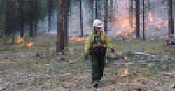 |
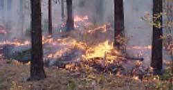
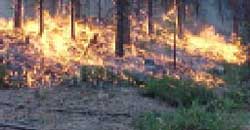
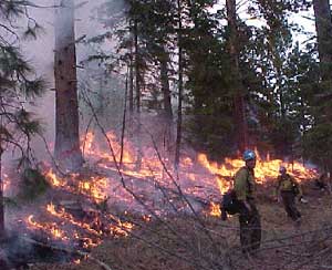
Fire Ecology in the North Cascades
Background
North Cascades National Park Service Complex includes lands in three
fire weather zones where there are varying patterns of fire occurrence,
severity and size. The primary fire management goals are to maintain
and/or reestablish the natural role of fire in the ecosystem where
possible given the constraints of safety, protection of sensitive
cultural and natural resources, and other management considerations.
However, only one portion of the Complex has been studied in depth (Agee
et al., 1986; Finney, 1986; Larson, 1972). Fire history research is
needed to establish the natural frequency of fire in different portions
of the Complex, and determine the impacts that modern human activities
have had on fire occurrence and fire extent. Knowledge of past fire
frequencies, fire origin (anthropogenic or natural), forest structure,
and successional patterns will aid park managers in identifying desired
future conditions regarding the role of fire.
Knowledge of past fire occurrence and behavior gives insight into probable future fire behavior, and thus may be used in preparedness planning (especially when prepositioning fire management resources); to refine fire use prescriptions (to define acceptable conditions for the management of natural ignitions); to help in the analysis of management options for new ignitions (Wildland Fire Situation Analysis); to identify locations where management action is needed to mitigate the impacts of recent human ignitions and suppression actions; to identify potential fire safety concerns for visitors and employees in the vicinity of wildland fires. Identification of cultural landscapes within the complex and quantify changes resulting from management actions.
Park Focus: NOCA
Research Needs
The Hozomeen and Stehekin areas of the park receive little rainfall
(approximately 30" per year) and are believed to fall in the
moderate severity fire regime. Due to their fire frequency, the
presence of developed zones, and the possibility of historical
anthropogenic fires in these areas, they are the highest priority sites
for fire research. What is the fire history of the Hozomeen and
Stehekin areas? What were the frequency, seasonality, and range of
variability in each of fire in these areas? What were the sizes of past
fires and their spatial distribution?
What is the influence of landform (i.e., slope, aspect, topographical fire breaks) on fire spread and fire severity throughout the park?
The drainages east of Ross Lake and Granite Creek appear to contain forest habitats that support wildlife species of concern such as lynx, fisher, wolverine and marten. What is the role of fire in this area with respect to forest structure, patch sizes, and successional stages in this forest? Has fire suppression in this area affected species of concern habitat and, if so, to what degree? What is the anthropogenic influence on fire in this area and how has it changed over the past several centuries? How has the mosaic of forest habitats changed in this area over the past several centuries and what factors have influenced these changes?
How has the construction of Ross Dam and change in size of Lake Chelan influenced historic fire patterns?
What is the effect of prescribed burning season (i.e. spring vs. fall) on plant species composition, establishment of exotic plant species, fuel loading, and wildlife species in the Stehekin area?
What is the fire history of whitebark pine communities in the park? (see whitebark pine section)
Resources Available
Individual Fire reports are available for fires that occurred from 1956
through the present. History of fire suppression is available from
Forest Service Fire Atlases in both mylar maps of fire polygons and
summarized tables. These data cover the era 1908 - 1959 and display all
suppression actions occurring on the Mount Baker Snoqualmie National
Forest during that period.
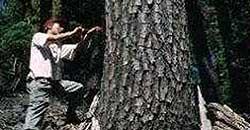
A detailed fire history study was performed in 1986 for the Desolation Peak area in the northeast corner of the Complex. (Agee, 1986)
A USFS 1916 Timber Survey of second growth displays disturbance from the previous 20-120 years. This is a mylar map of both the Mount Baker Snoqualmie National Forest and the North Cascades National Park.
Sediment cores from four lakebeds will be available by October 2000 for analysis of charcoal deposition.
Complete fire suppression area history of the North Cascades National Park Complex is expected to be available in GIS format soon.
Historical vegetation layer from 1922 for Stehekin Valley is available in digital format.
References Cited
Agee, J. K., M. Finney, and R. de Gouvenain. 1986. The fire history of
desolation peak. Final report, National Park Service, Cooperative
Agreement CA-9000-3-0004, subagreement 5, 76 p.
Finney, M. A. 1986. Effects of low intensity fire on the successional development of seral lodgepole pine forests in the North Cascades. M.S. Thesis. University of Washington, Seattle, WA, 140 p.
Larson, J. W. 1972. Ecological role of lodgepole pine in the upper Skagit River Valley, Washington. M.S. Thesis, University of Washington, Seattle, WA, 74 p.
Rev. 9/2000
| <<< Previous | <<< Contents>>> | Next >>> |
research-catalog/fire.htm
Last Updated: 05-Sep-2000