|
OREGON'S HIGHWAY PARK SYSTEM: 1921-1989 An Administrative History |

|
MAPS OF OREGON STATE PARKS
The three fold-out maps which follow give a graphic impression of the historical connection between State Parks and highway development in Oregon. From 1921 to 1989, the Parks Division was administered by the State Highway Commission and, ultimately, the Oregon Transportation Commission. During most of that period, acquisition and development was supported by the State Highway Fund, a dedicated fund of gasoline tax revenues.
In 1929, the Parks organization was established by appointment of a State Parks "engineer," and by that time only the bare framework of roadside parks on primary and secondary routes of the State Highway system had been laid. Over the years, park system management was assisted greatly by coordination of such services as road maintenance, directional signing and travel information for motorists within various branches of the Highway Department.
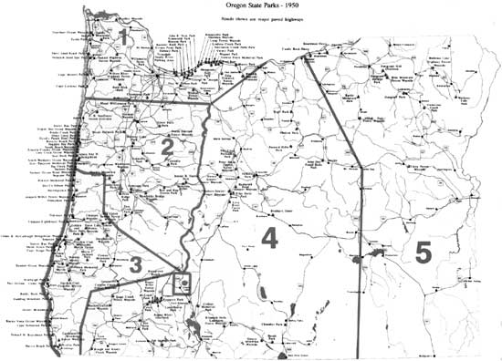
In 1950, the year the founding superintendent retired, the system of state parks showed the result of 21 years' concentrated effort in acquiring scenic and recreational areas, particularly along the coast and the Columbia River Gorge. The map for that year illustrates parallel improvement of the state road system as well, including completion of the Oregon Coast Highway in its central section.
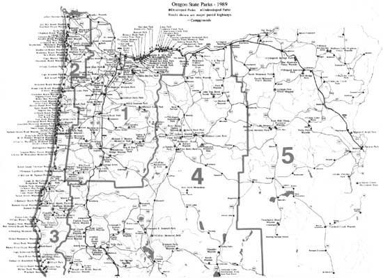
In 1989, the administrative connection between Parks and the Transportation Commission ended with creation of a separate department governed by a State Parks and Recreation Commission. The map for that year reflects the broadening of statutory authority during the 1960s and '70s in the addition of several historical waysides and numerous parcels for beach, trail, Willamette River Greenway and scenic waterway access. The last map also shows some reduction of park holdings through exchange and transfer. For example, by 1989, the Painted Hills and John Day Fossil Beds units in Region V had been deeded to the National Park Service for management as a National Monument, and Depoe Bay Ocean Wayside was transferred at no cost to the city of Depoe Bay for continued public recreation purposes.

|
|
OREGON STATE PARKS - 1929 Roads shown are major paved highways (click on image for a PDF version) |
|
|
OREGON STATE PARKS - 1950 Roads shown are major paved highways (click on image for a PDF version) |
|
|
OREGON STATE PARKS - 1989 Roads shown are major paved highways (click on image for a PDF version) |
| <<< Previous | <<< Contents>>> |
maps.htm
Last Updated: 06-Aug-2008