|
Padre Island
An Administrative History |

|
EXECUTIVE SUMMARY
Padre Island National Seashore, authorized by Congress in 1962, covers 66 miles of the approximately 113-mile long Padre Island in South Texas. Padre Island is the longest natural barrier island along the Gulf of Mexico broken only by the Mansfield Channel, a shipping channel dredged to the Port of Mansfield. The island is noted for its expansive white sandy beaches and tall foredunes that run along its eastern edge. On its western boundary, the island shelters the Laguna Madre, a shallow lagoon varying in width from several hundred to six miles in width. The lagoon is one of the richest habitats for sea and animal life along the Gulf Coast. Despite development to the north and south, Padre remains one of the most pristine seashore preserves in the United States and thus offers incomparable scenic and recreational opportunities. The island's diverse and fragile natural environment, however, is the primary focus of the park's interpretive programs as well as being the center of significant efforts in resource conservation.
The National Seashore lies approximately 30 miles southeast of Corpus Christi and 50 miles northeast of Brownsville. Interstate Highway 37, Highway 358, South Padre Island Drive, and Park Road 22 provide access to the northern end of the park. Headquarters are based in Flour Bluff 18 miles northwest of the park. Although most of the park is undeveloped, Malaquite Beach offers the largest visitor facilities. Gulf Ranger Station, three miles within the park's northern boundary, houses most of the ranger support facilities. Other areas with facilities include Bird Island Basin and Yarborough Pass.
The Malaquitas, a part of a larger tribe of Coahuiltecans, and the Karankawas roamed much of Padre Island for centuries. These Native Americans left few occupation sites, but were reported by European explorers as early as 1519 and again in an ill-fated 1554 Spanish expedition. Padre Nicholas Balli, a Catholic priest, and his nephew, Juan Jose Balli, received a Spanish grant for the first settlement of the island by 1820. The Balli family established the first cattle ranching on the island and is responsible for the name "Padre Island." In 1879 Patrick Dunn, known as the "Duke of Padre," leased part of the island for cattle ranching and continued to expand his ranching operation on the island through the 1920s.
Patrick Dunn's long tenure on the island ended with the arrival of automobile tourists and the Texas state park program in the 1920s. Under the direction of Governor Pat Neff and San Antonio booster David E. Colp, Padre Island and other significant resources of Texas were considered for state parks. Private investors found Padre Island's resources as attractive for development as those interested in a park designation. Several plans for major development offered during the 1920s and again in the 1950s never materialized leaving most of the island in its pristine state. The National Park Service also expressed interest in the island at various times from the 1930s through the 1950s, but never exercised any firm commitment to parkland acquisition or legislative action.
In 1958, Senator Ralph W. Yarborough of Texas offered the first bill in Congress for establishing an 88-acre Padre Island National Park. Although not successful, Yarborough continued to introduce legislation in subsequent sessions but later changed the designation to Padre Island National Seashore. At the opening of the 87th Congress in January 1961, Senator Yarborough again introduced S.4 while Representatives Joe Kilgore and John Young introduced H.R. 5013 and H.R. 5049, respectively. The latter bills differed in several substantive ways including reducing the length of the proposed National Seashore and authorizing construction of a road the full length of the island. After subcommittee and committee hearings in 1961 - 1962, Yarborough's initiative stalled because of differences with Texas officials on mineral extraction in the tidelands and the size and accessibility of the park.
Senator Yarborough, however, took a decisive step in the spring of 1962 and maneuvered S.4 to the full Senate for consideration. On April 11, 1962, the Senate passed the bill and forwarded it to the House for approval. Representatives in the House amended S.4 but substantively authorized the National Seashore. President John F. Kennedy signed the bill on September 28, 1962, in the presence of Senator Yarborough and many longtime supporters. In August of the following year, Land Commissioner Jerry Sadler, Governor John Connally, and Attorney General Waggoner Carr deeded the Texas-owned land within the park boundaries to the Federal government ending the State's long-held ambivalence toward the designation.
The National Park Service appointed the first superintendent and began land acquisition for Padre Island National Seashore in the summer of 1963. Conflicting land surveys, reluctant property owners, law suits, and an ever-changing shoreline complicated early efforts to acquire land. After efforts to acquire the parkland and several appropriations by Congress, the Park Service, U.S. Attorney General, and a Federal judge from South Texas agreed in December 1968 to a reduction in park size to 66 miles, extending seven miles south of Bob Hall Pier to the Mansfield Channel. The following July 1969 Congress passed a final appropriation of $4.1 million to complete the purchase of parkland with the compromise. Park planning proceeded at the same time resulting in the release of a master plan in 1964 and the opening of a permanent park headquarters in Flour Bluff in March 1965. North and South Districts, established in the mid 1960s, demonstrated the commitment to park facilities on both ends of the National Seashore. The first and most intensive development occurred at the North District station, some 12 miles south of Bob Hall Pier. Later named for the island's native Coahuiltecan tribe, the Malaquite Beach facilities included 11 planned buildings and structures placed along the foredunes overlooking North Beach. Construction work ended in late 1969 allowing for full operation of the park beginning with the 1970 season. The Park Service abandoned plans for development at the South District station after attempts at area land acquisition failed.
|
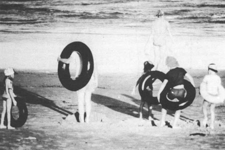
| Figure 1. Park Visitors along Malaquite Beach. Photo courtesy PAIS Archives [960]. |
From 1970 to 1980, National Seashore personnel faced a number of challenges to the operation of the new park. Several buildings among the Malaquite Beach facilities began to show signs of stress from the harsh environment along the foredunes and construction defects. The problems persisted despite attempts to stabilize the facilities and remained a serious maintenance issue into the next decade. Park staff also settled longstanding environmental problems by ending cattle grazing on the island and negotiating a settlement to remove the makeshift cabins on the spoil islands in the Laguna Madre. These two accomplishments conformed to the reports issued during the early 1970s on the island's natural resources and the adopted Master Plan. In 1975 park administrators finally settled a debate concerning the permanent location of the headquarters with the selection of a new building at 9405 South Padre Island Drive in Flour Bluff.
In August 1980, Hurricane Allen formed in the Caribbean and made landfall near the Mansfield Channel along Padre Island. The hurricane left much of the island in a shambles and pointed to the importance of integrating human occupation with the island's natural features. In the aftermath of Hurricane Allen the Park Service reevaluated existing plans and released a new General Management Plan/Development Concept Plan by 1982 and Land Protection Plan by 1985. Natural resource management now became the priority for the National Park Service as it stepped up its research programs to better understand the functions of the barrier island and island wildlife. In the meantime, the Park Service planned and designed a new visitor facility to replace the Malaquite Pavilion. The contractor turned over Phase I of the new facilities to the National Seashore staff in July 1989 and Phase II in 1990.
By the mid 1990s, Padre Island National Seashore offered an assortment of recreational opportunities and numerous visitor services. Annual visitation figures indicated a relatively consistent number of visitors taking advantage of the park's facilities and resources. New bilingual interpretive exhibits and programs enhanced early park public relations and education by reaching the growing regional population. A progressive natural resource program also synthesized previous research and established new baseline data. After more than 30 years of park operations, Padre Island National Seashore operated as a stable unit of the diverse national park system seemingly on course with its commitment to balance recreation with resource conservation.
| <<< Previous | <<< Contents>>> | Next >>> |
pais/adhi/summary.htm
Last Updated: 14-Jun-2005