|
National Park Service
A Study of the Park and Recreation Problem of the United States |

|
MISSOURI
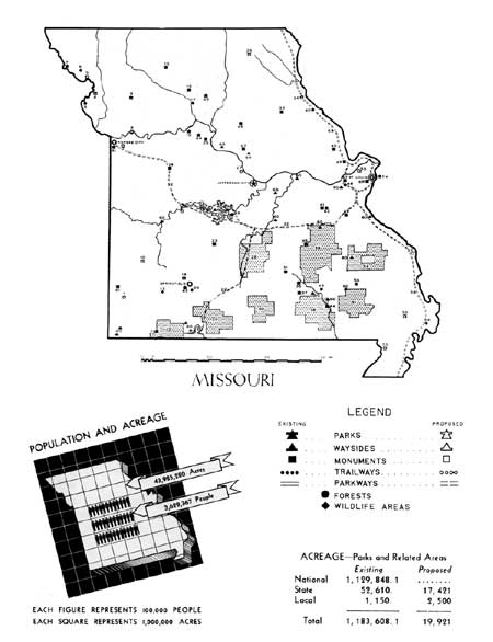
ONE-THIRD OF THE POPULATION of Missouri is concentrated in St. Louis and Kansas City and nearly 40 percent live in the six cities having over 25,000 population. In general, the rural counties show a consistent decrease in population. The Ozark region contains the lowest population density. Approximately 6 percent of the total population is Negro.
The Ozark region, which contains two national forests, several state parks and forests, and a vast area of wooded hills, clear streams, and spectacular springs, constitutes the major recreation area of the State. It is visited by many thousands annually, both from Missouri and other states. However, the recreational possibilities of the Ozarks have hardly been tapped.
The metropolitan populations of St. Louis and Kansas City include a considerable number of residents of adjoining States. In each instance metropolitan park systems including areas both near and at some distance from the cities, as well as integrated systems of parkways and freeways are desirable.
In the rural districts the need is primarily for local areas affording opportunities for people to congregate and enjoy the benefits of social, athletic, and cultural activities which are now lacking.

(click on image for an enlargement in a new window)
| FEDERAL | ||
| National memorial project: | ||
| 54. Jefferson National Expansion Memorial | ||
| Recreational demonstration areas: | ||
| 14. Montserrat | 3,438.9 | |
| 28. Lake of the Ozarks | 16,037.2 | |
| 45. Cuivre River | 5,802 | |
| Total | 25,278.1 | |
| National forests: | ||
| 12. Table Rock | 36,831 | |
| 21. Pond Fork | 95,800 | |
| 29. Gasconade | 114,243 | |
| 30. Gardner | 83,066 | |
| 38. Fristoe | 270,213 | |
| 39. Clark | 326,790 | |
| 51. Wappapello | 115,719 | |
| 52. St. Francois | 45,985 | |
| Total | 11,088,647 | |
| National wildlife areas: | ||
| 6. Squaw Creek | 6,742 | |
| 17. Swan Lake | 9,181 | |
| Total | 15,923 | |
| Proposed national parkway: | ||
| 58. Mississippi River | ||
| STATE | ||
| State parks: | ||
| 7. Big Lake | 100 | |
| 8. Wallace | 120 | 200 |
| 11. Roaring River | 2,690 | 1,270 |
| 15. Crowder Memorial | 635 | 525 |
| 16. Pershing Memorial | 1,800 | 360 |
| 18. Van Meter | 506 | 320 |
| 23. Bennett Spring | 572 | 846 |
| 31. Montauk | 754 | 773 |
| 33. Mark Twain Memorial | 1,083 | 200 |
| 36. Round Spring | 77 | 100 |
| 37. Alley Spring | 427 | 1,493 |
| 41. Meramec | 3,422 | 600 |
| 44. Big Spring | 4,416 | 2,034 |
| 47. Babler Memorial | 1,872 | 1,200 |
| 49. Washington | 694 | |
| Total | 19,168 | 9,921 |
| Recommended State parks: | ||
| 5. Andrew or Holt Counties | ||
| 9. Platte, Clay, Ray, Jackson, or Lafayette Counties | ||
| 10. Vernon, Barton, Cedar, or Dade Counties | ||
| 24. Benton, Morgan, or Camden Counties | ||
| 26. Schuyler, Scotland, Adair, or Knox Counties | ||
| 27. Monteau, Cole, Boone, Calloway, or Osage Counties | ||
| 57. Perry or Cape Girardeau Counties | ||
| Total | 7,500 | |
| State monuments: | ||
| 25. Arrow Rock | 32 | |
| 46. Fort Zumwalt | 45 | |
| Total | 77 | |
| State forests: | ||
| 35. Indian Trail | 13,256 | |
| 42. Meramec | 3,750 | |
| 43. Deer Run | 8,461 | |
| 50. Sam A. Baker | 4,423 | |
| Total | 29,890 | |
| State wildlife areas: | ||
| 3. Lewis and Clark | 43 | |
| 13. Chesapeake | 117 | |
| 20. Sequiota | 15 | |
| 40. DuPont | 1,100 | |
| 48. Rockwoods | 1,100 | |
| 59. Big Oak Tree | 1,100 | |
| Total | 3,475 | |
| State waysides: | ||
| 19 areas | ||
| Recommended State parkways: | ||
| 22. Gasconade | ||
| 32. Ozark | ||
| LOCAL | ||
| Recommended county parks: | ||
| 34. Mark Twain Cave—near Hannibal | ||
| 55. New Madrid, Dunklin, or Pemiscot Counties | ||
| 56. Stoddard, Scott, or New Madrid Counties | ||
| Total | 2,500 | |
| Municipal parks: | ||
| 61. Joplin (3 areas) | 286 | |
| 62. Springfield (3 areas) | 264 | |
| 63. Kansas City (1 area) | 20 | |
| 64. Marshall (1 area) | 105 | |
| 65. Brookfield (1 area) | 38 | |
| 66. Moberly (2 areas) | 340 | |
| 67. Columbia (1 area) | 30 | |
| 68. Saint Louis (1 area) | 67 | |
| Total | 1,150 | |
| Recommended metropolitan park systems: | ||
| 1. Joplin | ||
| 2. Kansas City | ||
| 4. St. Joseph | ||
| 19. Springfield | ||
| 53. St. Louis | ||
1 Area under Federal administration June 1938.
| <<< Previous | <<< Contents>>> | Next >>> |
park-recreation-problem/missouri.htm
Last Updated: 18-May-2016