.gif)
Parks for America
MENU
![]() Findings and Recommendations
Findings and Recommendations
|
Parks for America
|

|
|
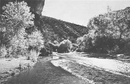
| Aravaipa Canyon is proposed for Arizona State park status. (ESTHER HENDERSON.) |
ARIZONA
ARIZONA, "the Grand Canyon State," has a wide variety of mountain, desert, and water resources with a wealth of sunshine that makes it a State noted for both summer and winter vacations.
The population increased 73 percent between 1950 and 1960 to 1,302,161. It is estimated it will reach 2,144,000 by 1976. The urban population increased 133 percent in the last decade and now stands at 74.5 percent of the total population. The average density is 11.5 per square mile, with a range from less than 1 per square mile in the Colorado River country to 72 persons in the Phoenix area.
The tourist industry in 1960 grossed $290 million, ranking it third in order of importance in the State's economy.
Existing Federal, State, and Indian highways afford good access to all areas of high recreation value.
In the north are the forested Kaibab and Coconino plateau regions bisected by the Grand Canyon of the Colorado River. Northeastern Arizona features cliffs, buttes, mesas, and monolith formations of the high desert. Through the center of the State is a high, cool, forested plateau and mountain belt 55 to 100 miles in width. In the southern and western parts are immense desert regions. The Colorado, Gila, Verde, Little Colorado, and Salt Rivers, Tonto Creek, and Lake Mead and other large reservoirs are all significant to the statewide recreation picture. Mountain and desert regions are within day- and weekend-use distance of Phoenix and Tucson.
There is wealth of historic and archeologic sites associated with the prehistoric Indian, the Spanish and Mexican eras of settlement, and American exploration, pioneer travel, and early mining ventures.
|
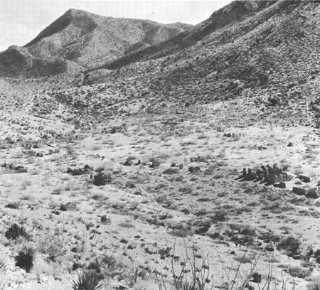
| Mountains brood over Fort Bowie's ruins. The old Arizona fort that stood watch at Apache Pass on the Butterfield Trail has been proposed as a national historic site. |
EXISTING PUBLIC AREAS
NATIONAL: The National Park Service administers 2 national parks, 15 national monuments, 1 national memorial, and 2 national recreation areas, with a total of 2,805,282 acres. The 1960 attendance was 5,441,800. There are seven national forests under administrative jurisdiction of the Forest Service, comprising 11,343,974 acres. Included in this total are 167 recreation developments on 3,159 acres, 13 wilderness areas of 716,415 acres, and 3 nature preserves with 2,100 acres. The Bureau of Sport Fisheries and Wild life manages five national refuges totaling 1,596,429 acres; these include six recreation developments and one nature preserve. Visits to these refuge areas amounted to 450,000 in 1960.
STATE: The State Parks Board administers three historical monuments, including 15 acres, and one 160-acre recreation area. The 1960 attendance was 170,000. Other State agencies administer three historic monuments, one recreation area, and a botanical garden. The State Game and Fish Department manages three wildlife refuges covering 3,450 acres. The State Highway Department maintains 379 roadside areas.
LOCAL: The Phoenix area has five major local parks with 89,072 acres and one recreation area of 12,883 acres. The Tucson area has two out-of-city parks with 18,280 acres. Mohave County has a 2,226-acre park and Coconino County a 640-acre park.
PRIVATE ENTERPRISE: Private enterprise plays a major role in providing outdoor recreation facilities. Under private ownership are four nature preserves, two wildlife refuges, and four monuments as well as numerous resort and tourist accommodations. Recreation areas provided by the Indians on reservation lands include 1 park of 90,000 acres and 23 other recreation developments.
PARK AND RELATED NEEDS
Present recreation needs are being met in Arizona on a wide front that includes Federal, State, local, Indian, and private lands and development. Consideration might also be given to the preservation of free-flowing streams; preservation of desert areas including buffer zones adjacent to highways, settlements, rivers, and reservoirs; improvement of scenic route and parkway standards; and to enlarging the scope and activities of the State park system to accomplish these goals. Potential State recreation lands identified in this report total 107,976 acres.
Manicopa County has an adequate planning and development program designed to meet foreseeable needs within a 30-mile distance of Phoenix. State wide needs for local nonurban areas can be substantially met by acquisition of potential recreation lands identified in this plan, which comprise some 142,200 acres.
|
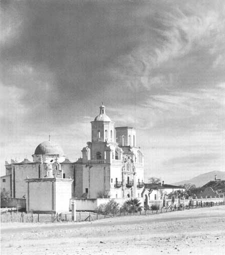
| San Xavier del Bac, near Tucson, Arizona, established in 1700 as the northernmost of a chain of 24 missions to the Indians. The present church, consecrated in 1797, is one of the finest architectural examples of its kind. |
RECOMMENDATIONS
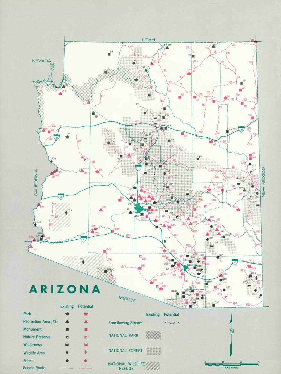
Existing recreation resources and many potential areas are shown on the accompanying tabulation and map. The following recommendations are made to help provide needed outdoor recreation opportunities for public enjoyment and use.
NATIONAL: Establishment of the Hubbell Trading Post and Fort Bowie as national historic sites and further study of the Meteor Crater for public park purposes.
STATE: Expansion of the State park system to preserve significant resources by the addition of 13 parks, 8 recreation areas, 5 scientific monuments, 17 historic monuments, and 9 nature preserves, and further study of 5 other potential areas. Designation and protection of 53 scenic roads and 3 free-flowing streams.
LOCAL: Establishment of 4 major local parks and 13 recreation areas in the Phoenix, Tucson, Flagstaff, and Yuma areas.
Supporting recommendations include—
1. Establishment of city, county, and State recreation areas along the Lower Colorado River from Davis Dam to the Mexican border.
2. Development of hiking and riding trails along the Santa Cruz River, San Pedro River, Bloody Basin, and Seven Springs, and from Phoenix to Black Canyon.
3. Preservation of desert flora including outstanding Mesquite and Palo Verde Forests.
4. A special survey of the northwestern corner of the State to determine the recreation values of that largely undeveloped section.
(Table omitted from online edition)
|
| (click on image for an enlargement in a new window) |
NEXT >>>
 Top
Top
|
|
Last Modified: Mon, Sep 6 2004 10:00:00 pm PDT
parks_america/arizona.htm