.gif)
Parks for America
MENU
![]() Summary
Summary
|
Parks for America
|

|
|
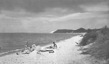
| Seashores and lakeshores, like this at Sleeping Bear Dune, Michigan, are favorites for recreation. Such resources, fast vanishing under developments, need local, State, and Federal conservation. |
SUMMARY
Presented in this report is a State-by-State inventory of some 4,800 existing nonurban park and related areas. Major features of existing areas are examined, but more significantly, opportunities to protect approximately 2,800 additional areas with important scenic, scientific, historic, and other recreation values are identified.
Surveys conducted in cooperation with State and local park organizations from 1956 to 1962 provided data for the report. Certain Federal agencies with land management responsibilities also furnished information.
The broad findings and recommendations of the Outdoor Recreation Resources Review Commission, contained in its January 1962 report to the President and the Congress,* are considered here as they affect State planning. Generally, the Commission found that present park systems are inadequate—they have not kept pace with increasing demands, acreages are not adequately distributed to serve urban needs, or systems lack balance to provide varied types of recreation activities.
* Outdoor Recreation for America, Superintendent of Documents, Government Printing Office, Washington D.C. 20402. $2.50.
Urban sprawl and other developments are threatening to destroy scenic, scientific, and historic resources that, once lost, cannot be replaced. Hence, identification of such irreplaceable values was given first consideration in formulating the report's recommendations. It is recognized, of course, that the protection of these resources would not solve the problems of total need with respect to population distribution.
Potential areas that could fill some of the gaps and needs of present park systems were identified by extensive field surveys. These areas have been evaluated as to their significance—National, State, or local—and are so tabulated for each State. The tabulations also include recommended additions to existing areas. The accompanying table classifies the 2,683 potential State and local areas.
Potential State and Local Areas
| Area classification | Number of sites |
Acres | Miles |
| State significance: | |||
| Parks | 417 | 3,272,000 | |
| Recreation areas | 573 | 2,174,100 | |
| Scientific monuments | 88 | 452,500 | |
| Historic sites | 251 | 72,100 | |
| Nature preserves | 108 | 672,900 | |
| Wilderness areas | 5 | 561,100 | |
| Beaches | 78 | 155,000 | |
| Parkways | 9 | 870 | |
| Scenic roads | 478 | 38,600 | |
| Free-flowing streams | 149 | 11,700 | |
| Canoe trails | 127 | 9,000 | |
| Foot trails | 5 | 1,900 | |
| Total | 2,297 | 7,359,700 | 62,070 |
| Local significance: | |||
| Parks | 116 | 239,900 | |
| Recreation areas | 233 | 331,100 | |
| Scientific monuments | 4 | 250 | |
| Nature preserves | 14 | 31,500 | |
| Beaches | 19 | 8,700 | |
| Total | 386 | 611,450 | |
The nationwide investigations revealed certain outstanding areas that may be of national significance. Continuing studies will determine which of these and other possible areas might be worthy of inclusion in the National Park System. This report recommends further consideration be given to 84 such areas. Included in the total are 26 sites identified through the National Survey of Historic Sites and Buildings and recommended by the Advisory Board on National Parks, Historic Sites, Buildings, and Monuments.
NATIONAL PARK SYSTEM PLANNING
Through studies with the States, the historic sites survey, and other cooperative studies, many areas considered to be of national significance have been identified. It is generally accepted that it is in the national interest to conserve areas of outstanding scenic, scientific, and historic importance—areas of superlative natural beauty and those that interpret the natural history of this continent and the story of man's career in America.
The National Park Service was established to preserve these cultural values unimpaired for the enjoyment of future generations. But the National Park System as we know it today does not include all that it should. There are types of nationally significant areas wholly omitted or inadequately represented.
The phenomenal continuing increase and changing pattern of public use raises questions about the adequacy of the System in both the number and kinds of units it contains. Even as the public need for parks increases, remaining areas of national significance that are suitable for inclusion in the National Park System decrease in size and number with the advance of the Nation's development. It is a purpose of the Department of the Interior, therefore, to formulate a long-range National Park System Plan for the orderly achievement of a well-rounded, complete, and adequate system of nationally significant parks in appropriate classifications. Some suitable areas still remain for achieving this objective.
|
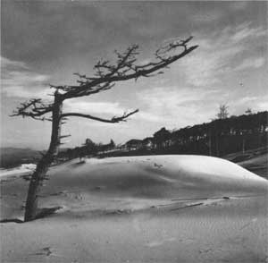
| Pines battle drifting sands at the Oregon Dunes, proposed as a national seashore. |
A portion of the great prairie of Kansas and Jemez Crater in New Mexico are examples. The canyon-lands in Utah possess some of the world's finest scenic and geologic values. The Allagash River country in Maine and the proposed Ice Age National Scientific Reserve in Wisconsin contain outstanding resources. But permanent protection of these areas is not assured as yet.
Congress has considered numerous proposals for the establishment of new national parks, national monuments, and other types of areas during recent years. Cape Cod National Seashore, Mass., and Fort Davis National Historic Site, Tex., are examples of areas authorized in 1961. Point Reyes, Calif., and Padre Island, Tex., were authorized as national seashores in 1962. Other outstanding proposals introduced or considered by Congress during 1962 were Sleeping Bear Dunes, Pictured Rocks, and Indiana Dunes National Lakeshores; Oregon Dunes National Seashore; Prairie, Canyonlands, and Great Basin National Parks; Ozark National Rivers; Tocks Island National Recreation Area; Ice Age National Scientific Reserve; Chesapeake and Ohio Canal National Historical Park; and Fort Bowie National Historic Site.
The accompanying map identifies 84 possible additions to the National Park System. Of these, 11 have been authorized for establishment by the Congress, but the lands have not yet been acquired. The 16 areas listed above are included on this map.
EXPLANATION OF STATE
SUMMARIES
In presenting the results of preliminary park and recreation area studies in cooperation with each of the 50 States, the Bureau of Census regions have been used as a means of grouping and coordinating the States with similar socioeconomic and, to a degree, physiographic backgrounds. Each of the four major regions (Northeast, South, North Central, and West) is prefaced by a brief description of the park and related resources, climate range, population trends, and outdoor recreation use patterns. Also included is a resume of existing public park and related areas and facilities, the role of private enterprise in the outdoor recreation picture, and an analysis of the region's overall needs for parks and related areas.
Each regional résumé is followed in alphabetical order by brief summaries for each of the States in the region. The individual State summaries include a one-page résumé, a map and tabulation of existing and potential parks, monuments, recreation areas, parkways, scenic roads, trails, and free-flowing streams. Following is an explanation of the material included in each State summary:
Text
Items covered, where pertinent, include brief statements on existing and projected population trends, the relation of outdoor recreation to the economy, facility of access to recreation resources, major overall physiographic features, and significant historic and archeological sites. Also included is a résumé of existing National, State, local, and private park and related areas; a résumé of statewide needs; and a résumé of specific recommendations on a National, State, and local basis.
|
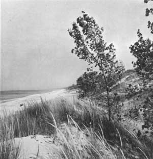
| The beauty, scientific importance, and recreation potential of the Indiana Dunes have prompted park proposals for the area since 1916, and a small portion was established as a State park. Now the last remaining unspoiled dunelands are proposed for a national lakeshore. |
Maps
Green is used to indicate county lines, major metropolitan areas, major streams, lakes, and reservoirs, and the proposed Federal Interstate Highway network.
Existing Federal, State, major local, and private areas which are used by the public for outdoor recreation purposes are shown in black. National parks, national forests, and national wildlife refuges are shown by symbol and, when of sufficient size, by cross-hatch, dotted, and single-hatch pattern, respectively, to indicate overall project boundaries—not necessarily lands in Federal ownership.
All existing State park areas are shown, but only those State forests and wildlife areas which receive significant recreation use other than for hunting and fishing are indicated. Where these areas are sufficiently large, they have been shown in outline parks by a solid line, forests by a dashed line.
Red is used for potential National, State, and local park and related areas which are shown by symbol and, where of sufficient size, by pattern. The symbol for recreation area is used also to designate seashores, rivers, etc., where preservation is a primary objective. This report does not identify potential State or local parks, recreation areas, or historic sites within exterior boundaries of national forests. All potential scenic roads involve existing State or interstate routes; potential historic sites are limited to those sites of National or State significance which are recommended for acquisition and administration by a public or quasi-public agency.
Tabulations
All existing areas are listed according to the level of present administration and are classified according to the definitions presented in the "Guidelines" set forth in the appendix. All potential areas are classified also according to the same definitions, but are listed according to significance rather than suggested level of government administration.
For existing national forests, wildlife areas, and areas administered by the National Park Service, only acreage in Federal ownership is shown.
Federal reservoirs are listed under "Existing Federal" where a Federal agency administers and maintains recreation facilities at the reservoir. Where the recreation use of a Federal reservoir is administered by a State or local agency, it is listed as a State or local area.
Existing historic sites listed are limited to sites of State or National significance open to the public and administered by a Federal, State, or quasi-public agency.
|
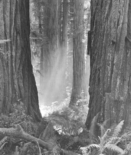
| The coast redwoods of California epitomize America's heritage of natural wonders. Other groves like this, in Jedediah Smith Redwoods State Park, need protection. (Moulin) |
NEXT >>>
 Top
Top
|
|
Last Modified: Mon, Sep 6 2004 10:00:00 pm PDT
parks_america/summary.htm