.gif)
Parks for America
MENU
![]() Findings and Recommendations
Findings and Recommendations
|
Parks for America
|

|
|
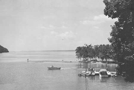
| The proposed Between-the-Lakes National Recreation Area in Kentucky and Tennessee, with some 285 miles of shoreline, offers outstanding water-based recreation opportunities. |
KENTUCKY
MOUNTAINS in the east and hill country and flatlands to the west combine to offer diversified recreation opportunities and potential in Kentucky.
The State's population increased 3.2 percent between 1950 and 1960 to 3,038,156. Projections indicate 3,363,000 by 1976. There is an average density of 76 persons per square mile, ranging from less than 20 in Trigg County to over 500 in counties along the Ohio River. Forty-five percent of the population is urban, concentrated chiefly in and around Louisville, Lexington, Ashland, Covington, and Henderson.
An estimated $565 million was spent on tourism in 1959, ranking that industry seventh in the State's economy behind others such as agriculture, mining, and manufacturing.
Except for the eastern mountain section, Kentucky's recreation resources are accessible by means of the present road system. Five interstate routes and the Kentucky Turnpike will improve traffic flow.
Kentucky has three distinct regions: Cumberland Mountains in the east; Blue Grass uplands in the middle; and low plains in the west. The mountains offer not only relief from high temperature and humidity in summer, but the possibility of developing winter sports. About half the State remains forested.
Reservoirs provide existing and potential outdoor recreation opportunities, and other State and Federal water-control projects should increase such opportunities, especially in meeting local needs. There are 14,000 miles of running streams. Pollution is a continuing problem, although abatement procedures are progressing. Mineral extraction is an adverse factor in the recreation picture.
Existing and potential historic areas present the State's role in the first major westward movement and settlement beyond the Alleghenies and the important part played by Kentuckians in shaping national policies and national destiny. Four sites have been evaluated as possessing exceptional value in commemorating the history of the United States—Ashland in Lexington, Taylor House in Springfield, Perryville Battlefield, and Indian Knoll.
|
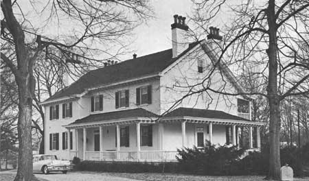
| Springfield, the Zachary Taylor House in Louisville, Kentucky, was the future President's home until his father's death in 1829. (THE LOUISVILLE COURIER-JOURNAL.) |
EXISTING PUBLIC AREAS
NATIONAL: The National Park Service administers a national park, a national historical park (partly in Tennessee and Virginia), and a national historic site, totaling 61,492 acres, with a 1960 attendance of 985,584. The Tennessee Valley Authority administers 1 reservoir (partly in Tennessee) of 158,300 total water-acres that had an attendance of 7,748,449 in 1960. The Corps of Engineers administers seven reservoirs. Two are under construction and three are partly in Tennessee. They have a total of 148,475 water-acres and had an attendance of 4,229,900 in 1960. The three major reservoirs, totaling 135,920 water-acres, are listed in the tabulation. The Forest Service administers 10 recreation areas totaling 600 acres in 1 national forest of 459,661 acres. The Bureau of Sport Fisheries and Wildlife administers two refuges (one partly in Tennessee) with 66,568 acres.
STATE: The Department of Parks has 33 parks (26,155 acres) that had an attendance of 5,500,000 in 1960. The Breaks Interstate Park Commission administers a 1,548-acre park on the Virginia-Kentucky line. The Kentucky portion of 30 acres is presently undeveloped. The Department of Fish and Wildlife Resources administers 64,790 acres in nine game management areas (not tabulated). The Department of Conservation administers six forests of 40,684 acres (not tabulated). There are 370 roadside parks administered by the Department of Highways (not tabulated).
LOCAL: Jefferson County operates nine parks of 2,700 acres and one forest of 1,489 acres. The city of Louisville operates one nonurban park of 2,200 acres.
PRIVATE ENTERPRISE: Bernheim Forest is an outstanding exception to the general lack of recreational development of private lands. Shakertown at Pleasant Hill exemplifies private effort in preserving segments of Kentucky's history. Concession type facilities are well developed on reservoirs.
PARK AND RELATED NEEDS
The State park system will be enhanced both by the further development of existing areas and by the addition of new areas under the new revenue bond program. Such developments and acquisitions should be studied carefully in order that proper distribution and balance may be achieved and so that the areas and the developments on them may contribute best to the needs of the people of the State. The greatest area of need is that embracing Louisville, Lexington, and Covington.
For the present Population of more than 3 million, existing State recreation areas now provide only 26,155 acres, and local areas, 6,389 acres. Even if these were ideally distributed, they still would meet only a fraction of the need. Potential areas identified in this plan total 16,272 acres of State significance and 575 acres of local significance. These fall far short of meeting present needs—needs which will be even greater by 1976.
|
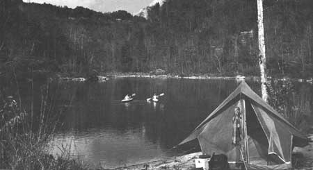
| The Cumberland River's scenic solitudes and free-flowing course suggest designation as a canoe trail. |
RECOMMENDATIONS
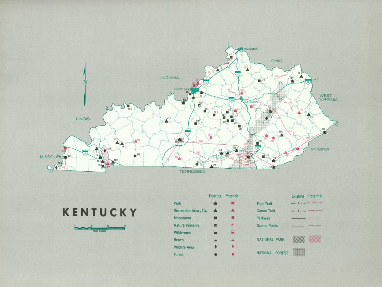
Existing recreation resources and many potential areas are shown on the accompanying tabulation and map. The following recommendations are made to help provide needed outdoor recreation opportunities for public enjoyment and use. Vigorous action will be needed to carry out such recommendations.
NATIONAL: Establish the Between-the-Lakes National Recreation Area. Study the feasibility of an Allegheny National Parkway extending from Hagerstown, Md., to Cumberland Gap National Historical Park. Study a feasible route which might lead to establishing a parkway connecting Great Smoky Mountains, Cumberland Gap, Mammoth Cave, and Natchez Trace. Portions of all these areas lie in other States.
STATE: Enlarge the State park system to preserve more scenic, scientific, and historic features. Five areas are recommended, and seven additional areas are suggested for further study. Segments of five streams are suggested as canoe trails, and portions of six existing highways are considered important for designation as scenic routes.
LOCAL: Provide areas to meet local recreation needs. Two areas are suggested; additional areas should be provided.
Supporting recommendations include—
1. Study of the rivers and streams of the State to determine whether portions of them should be designated as free-flowing streams and developments controlled to protect their natural condition.
2. Provision for additional waysides along highways to improve pleasure driving for tourists and residents.
3. Cooperative planning by State agencies to assure recreational development on lakes in the small lakes program. Three major lakes in this program are within the Louisville-Lexington-Covington region—the area of greatest need.
(Table omitted from online edition)
|
| (click on image for an enlargement in a new window) |
NEXT >>>
 Top
Top
|
|
Last Modified: Mon, Sep 6 2004 10:00:00 pm PDT
parks_america/kentucky.htm