.gif)
Parks for America
MENU
![]() Findings and Recommendations
Findings and Recommendations
|
Parks for America
|

|
|
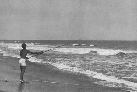
| Thirty-two-mile-long Assateague Island, in Maryland and Virginia, lying close to the metropolitan centers of Washington and Baltimore, represents one of the largest and last remaining undeveloped seashores of its size in the East. (U.S. FISH AND WILDLIFE SERVICE.) |
MARYLAND
MARYLAND, one of the Thirteen Original Colonies, extends from the Mason-Dixon line to the Potomac River and from the Atlantic Ocean to the Allegheny Mountains. Its rivers, bays, and ocean beaches serve the large urban population of the Baltimore-Washington region. The last remaining opportunities for acquisition of ocean beachland and Chesapeake Bay shoreland are rapidly disappearing.
The State population in 1960 was 3,100,689, a gain of 32.3 percent in the last decade. Projections indicate 4,490,000 by 1976. Seventy-two percent of the people live in urban areas. In 1960 there were 314 people for each square mile in the State.
Outdoor recreation ranks third in the State's economy, with an estimated tourist expenditure of $225 million for 1959.
Forests in the northwestern portion of the State and the rivers, bays, and ocean beaches are Maryland's primary recreation assets. Bay and tidal waters are brackish and pollution is a problem, but beaches are usable. There are very few natural lakes within the State. Existing flood-control and water-supply reservoirs offer possibilities for more extensive use.
The climate varies with the topography. Summers are hot and humid, and winters relatively mild in the bay and piedmont sections. The western mountain region is cool and pleasant in summer. Winters are cold, with snow for winter sports.
Hunting is an important recreational activity of the resident population. Stream and ocean fishing and crabbing are popular. Public access to fishing areas is good.
Maryland is rich in historic sites dating from the colonial period to the present time. Many sites are being preserved and restored by the Department of Forests and Parks. In addition to sites in the National Park System, five sites have been evaluated as possessing exceptional value in commemorating the history of the United States.
EXISTING PUBLIC AREAS
NATIONAL: The National Park Service administers five national monuments and historic sites and two parkways totaling 9,062 acres. The 1960 attendance was 714,000. The National Capital Parks System, administered by the National Park Service, includes a number of parks and related areas in Maryland totaling 14,322 acres. The Bureau of Sports Fisheries and Wildlife administers four national wildlife refuges of 16,795 acres. There are two reservoirs of 794 acres under the Corps of Engineers.
STATE: The Department of Forests and Parks, State Parks and Historic Sites Section, administers 20 parks and historic sites totaling 19,034 acres. The 1960 attendance was 3,263,684. The State Forests Section administers 119,669 acres in nine forests. The 1960 attendance was 549,755. The Game and Inland Fish Commission has 25,176 acres in 13 shooting areas and 11,623 acres in 25 game refuges. There is 1 historic site of 1 acre under the Maryland Tercentenary Memorial Commission and 105 waysides administered by the Roads Commission.
LOCAL: Major local nonurban park and recreation areas number 84, with 12,185 acres.
QUASI-PUBLIC AND PRIVATE: Three nature preserves consisting of 411 acres, 37 miles of the Appalachian Trail, and eight historic monuments.
PRIVATE ENTERPRISE: There are numerous private beaches and resorts on Chesapeake Bay, a major seaside resort at Ocean City, and extensive summer resort development in the mountain sections, particularly on Deep Creek Lake.
PARK AND RELATED NEEDS
The Baltimore and Washington, D.C., metropolitan areas generate major needs for day and weekend recreation. An immediate need exists for beach, marina, and boat-launching facilities tied in with existing State park development in the west shore region of Chesapeake Bay and at proposed areas of the State park system on the eastern shore. While a significant number of historic sites have been preserved and developed, rich historical resources remain to be added to a system encompassing representative periods of the State's history.
For the present population of over 3 million (including half of the District of Columbia population), existing State parks and recreation areas provide only 22,106 acres, and local areas an additional 12,185 acres. Potential areas of State significance identified in this plan total 136,824 acres. If these areas were acquired and developed, they would go a long way toward meeting the needs anticipated by 1976. Only 160 acres of potential local park areas are identified. Many more local areas should be acquired before the open space in urban areas disappears completely.
|
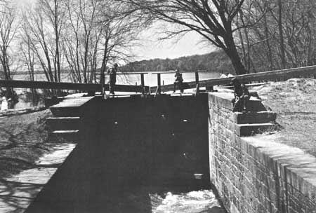
| Young anglers try their luck in the old Chesapeake and Ohio Canal, which parallels the Potomac River in Maryland. It is proposed as a 15,000-acre national historical park. (NATIONAL PARK SERVICE.) |
RECOMMENDATIONS
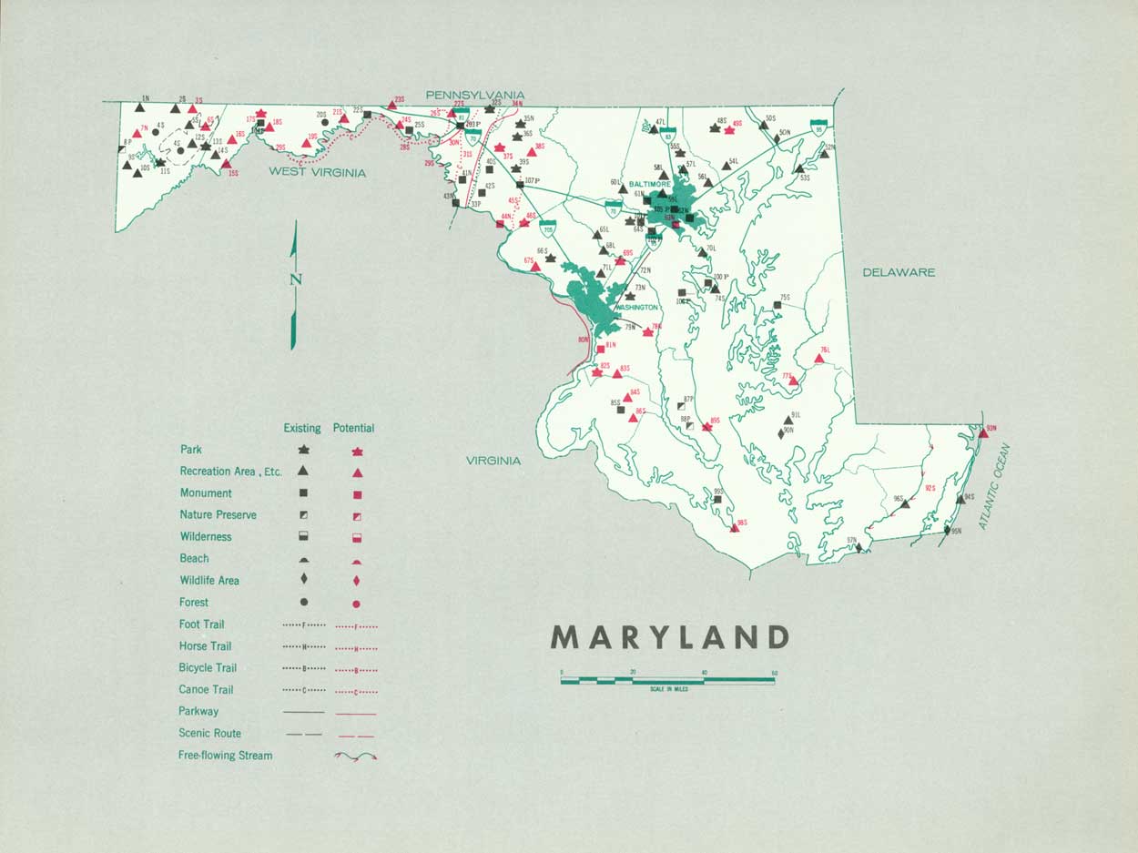
Existing recreation resources and many potentia] areas are shown on the accompanying tabulation and map. If the following recommendations are implemented by vigorous action on the part of the agencies concerned, they can help provide needed outdoor recreation opportunities for public enjoyment and use.
NATIONAL: Establishment of the Chesapeake and Ohio Canal as a national historical park, Assateague Island as a national seashore, and the Mount Clare Station and B&O Railroad Museum as a national historic site. Completion of the George Washington Memorial Parkway. Establishment of a Piscataway park as authorized by Congress. A feasibility study of an Allegheny parkway (4 miles in Maryland).
Further studies of the Youghiogheny River to determine its national recreation significance; the Patuxent and Suitland Bog for possible use as a unit of the National Capital Park System; and an Appalachian Parkway from Shenandoah National Park through Maryland and north into Pennsylvania and New England.
STATE: Expansion of the State park system by the addition of four new parks and six recreation areas and making major additions to five existing areas. Three other parks and 11 recreation areas are suggested for further consideration. Designation and protection of one free-flowing stream. Further study of a suggested free-flowing stream and of four suggested canoe trails.
LOCAL: Establishment of a Hunting Creek recreation area.
Supporting recommendations include—
1. Protection of all major river and stream courses from development and adverse use, and determined efforts to alleviate pollution in State waterways.
2. A comprehensive survey of archeological and historic sites and preservation of those found to possess educational and inspirational values.
3. A comprehensive study of the 3,600-mile shoreline of Chesapeake Bay to develop a long-range recreation plan for the protection and orderly development of the bay shorelands.
(Table omitted from online edition)
|
| (click on image for an enlargement in a new window) |
NEXT >>>
 Top
Top
|
|
Last Modified: Mon, Sep 6 2004 10:00:00 pm PDT
parks_america/maryland.htm