.gif)
Parks for America
MENU
![]() Findings and Recommendations
Findings and Recommendations
|
Parks for America
|

|
NEBRASKA
NEBRASKA is located in the central part of the great interior plain which stretches from Hudson Bay to the Gulf of Mexico. Two major rivers—the Platte and the Republican—cross the State from west to east to empty into the Missouri, which forms the eastern boundary of the State. These three rivers played an important role in the building of the West. It is the history connected with these rivers and the recreation along them today that are Nebraska's primary recreational resources.
|
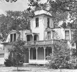
| Scout's Rest Ranch, home of "Buffalo Bill" Cody, near North Platte, Nebr., might make a significant State historic site. (NEBRASKA GAME FORESTATION AND PARKS COMMISSION.) |
The population increased 14 percent in the decade 1950-1960, to reach 1,411,330. An estimated 1,719,000 persons may be living in the State by 1976. The gain in the last decade was mainly in the cities, with losses in the rural sections, Omaha and Lincoln are the two metropolitan areas in the State. Fifty-four percent of the population was urban in 1960. The average density was 8.4 persons per square mile, with 10 counties having less than 2 persons per square mile.
The terrain varies from high plains and sand hills in the west, to the wooded river bluffs in the east. There are many water-storage reservoirs that provide opportunities for water recreation. Upland game birds, deer, and occasional antelope are prime hunting attractions. The central waterfowl flyway crosses the State and provides good hunting in fall and early winter.
Nebraska's climate is typical of the Great Plains. Winters tend to be long, severe, and windy; summers are hot.
The State's history covers the periods of early western exploration, fur trade, Oregon-California-Mormon Trail migrations, Pony Express, and Plains Indian wars. Historic sites and remaining evidences of old trails are numerous. Fort Atkinson, Fort Robinson, Robidoux Pass, and Signal Butte possess exceptional value in commemorating the history of the United States and are eligible for Registered National Historic Landmark status. The State is internationally known for its paleontological sites where many important fossil discoveries have been made.
EXISTING PUBLIC AREAS
NATIONAL: The National Park Service administers 2 national monuments totaling 2,334 acres which had an attendance of 110,147 in 1960. The Forest Service administers one national forest of 339,716 acres. The Bureau of Sport Fisheries and Wildlife administers 149,371 acres in five national refuges.
The Corps of Engineers has one reservoir of 31,600 acres under its jurisdiction. Chimney Rock, owned by the State, is a designated national historic site.
STATE: The Nebraska Game, Forestation and Parks Commission has a variety of areas under its administration with an attendance of 3,791,866 in 1960: 3 State parks, amounting to 2,428 acres; 4 monuments, 760 acres; 44 recreation areas, 48,169 acres; 16 wildlife management areas, 15,022 acres; and 6 waysides, 100 acres.
LOCAL: There are three major local areas totaling 1,385 acres in the Omaha-Lincoln areas.
QUASI-PUBLIC: There is one quasi-public nature preserve of 1,300 acres.
PRIVATE ENTERPRISE: Private industry plays an important part in providing recreation facilities at reservoirs.
PARK AND RELATED NEEDS
There are two distinct needs: additional camping, picnicking, and water-access facilities, particularly near the eastern cities; and greater emphasis on presenting the historic story to out-of-State visitors. Properly presented, the historic sites could become a major tourist attraction.
Existing State areas now provide 50,857 acres, and local areas, 1,385 acres. Potential areas of State significance identified in this plan total 42,948 acres, which would adequately meet State needs for 1976. Recommendations to meet the local need fall short, as only 2,500 acres have been identified. Further studies are needed to identify sufficient local areas to meet 1976 local needs.
|
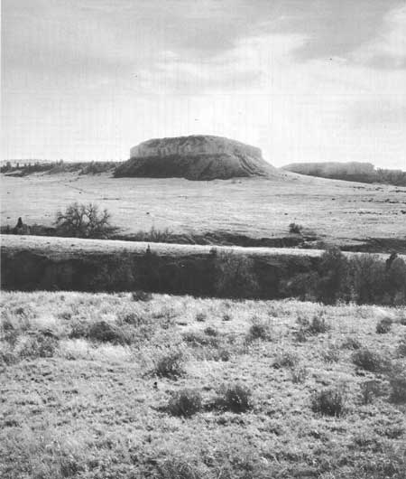
| Signal Butte, scenic landmark and important archeologic site in western Nebraska. (RIVER BASIN SURVEYS, SMITHSONIAN INSTITUTION.) |
RECOMMENDATIONS
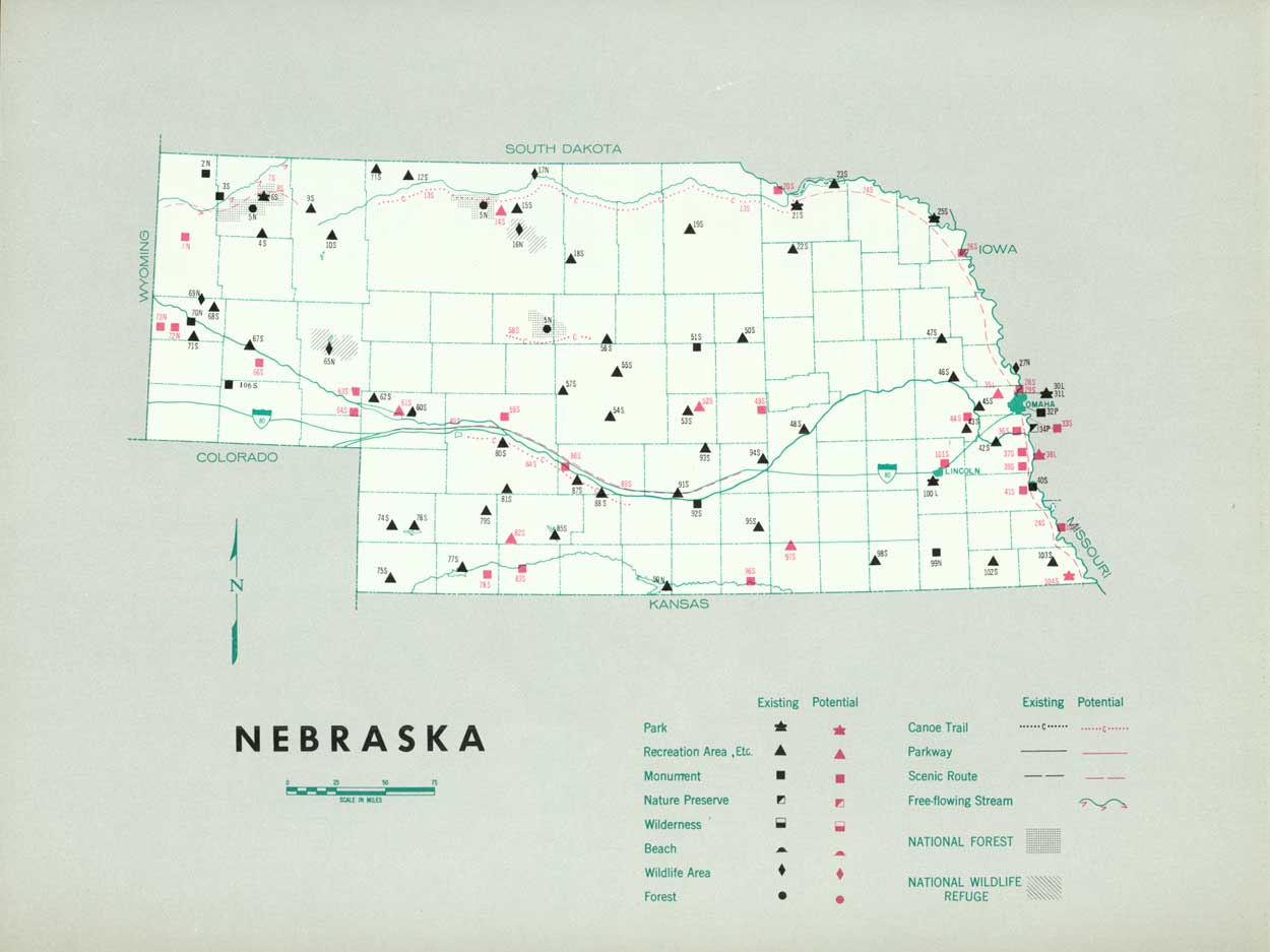
Existing recreation resources and many potential areas are shown on the accompanying tabulation and map. The following recommendations are offered to help provide needed outdoor recreation opportunities for public enjoyment and use. Prompt and determined action by the agencies concerned is a prerequisite of successfully filling outdoor recreation needs.
NATIONAL: Establishment of Agate Springs Fossil Quarries and further study of Robidoux Pass and Signal Butte as possible national monuments.
STATE: Expansion of the State park, recreation, and monument system to preserve valuable resources by the addition of one park, five recreation areas, and five historic monuments, Further study of 16 historic monuments. Designation and protection of three scenic roads and one canoe trail, and further study on one free-flowing stream and two canoe trails.
Supporting recommendations include—
1. Implementation of the State's 10-year plan for park and related area development and the addition of significant historic, archeologic, and natural sites for a balanced State park system. Continue to expand and emphasize the interpretive program.
2. Expansion of the staff of the Division of State Parks to include professional planning personnel.
3. Authorization of counties to form park boards as a logical complement to the recent law authorizing county planning commissions.
4. Expansion of the city park systems of Omaha, Lincoln, Grand Island, and other population centers to utilize the remaining local natural recreation resources supplemented by developed recreation areas.
5. Utilization of the Missouri River, including Lewis and Clark Lake, to develop a scenic drive, boating and access facilities, picnic and camping areas, and foot, horse, and bicycle trails along levees.
6. Establishment of a system of well-developed way sides.
7. Improvement of access to reservoirs and provision of adequate signing.
(Table omitted from online edition)
|
| (click on image for an enlargement in a new window) |
NEXT >>>
 Top
Top
|
|
Last Modified: Mon, Sep 6 2004 10:00:00 pm PDT
parks_america/nebraska.htm