.gif)
Parks for America
MENU
![]() Findings and Recommendations
Findings and Recommendations
|
Parks for America
|

|
|
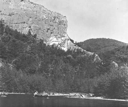
| The spectacular Smoke Hole area on the South Branch of the Potomac River in West Virginia is popular with canoeists. Protection of the South Branch as a scenic free-flowing stream is recommended. |
WEST VIRGINIA
WEST VIRGINIA, aptly called "The Mountain State," with an average altitude of 1,500 feet, is the highest State east of the Mississippi River.
The 1960 population was 1,860,421 a 7-percent decrease from 1950. However, projections indicate an increase to 1,905,000 by 1976. The greatest population losses were in the northern and central counties, while 12 counties along the Ohio and Kanawha Rivers and in the eastern panhandle showed gains. The average density is 77.3 persons per square mile, ranging from 11.6 percent in Pendleton County to 639.6 in Ohio County. Only 38 percent of the population lives in urban areas.
The State's economy has been based on coal mining and manufacturing. Tourism brought in an estimated $290 million in 1960 far behind its estimated potential. With the State's scenic mountain area within a 300-mile radius of 60 million people, it is possible that tourism could become the State's dominant industry.
Tourist surveys within West Virginia have consistently expressed a desire for highway improvement. Lately, the State has proposed the construction of a "Backbone Expressway System." Four planned Interstate Highways will also greatly improve access from other States. The pattern of mountains, valleys, rivers, and streams combines to create much scenic beauty. Half the State is forested. Water impoundments are becoming increasingly important as recreation assets. Industry and coal-mining wastes have brought about serious water-pollution problems. The State's high average elevation provides a salubrious climate; summers are warm but comfortable; winters are moderate to cold.
EXISTING PUBLIC AREAS
NATIONAL: The National Park Service administers one national historical park of 469 acres that had an attendance of 585,800 in 1960. The Corps of Engineers administers four reservoirs. The 1960 attendance was 797,300. It also has one reservoir now filling, and another under construction. The Forest Service administers 2 national forests totaling 903,980 acres, in which there are 9 campgrounds and 50 picnic areas on an estimated 2,100 acres, and 11 wildlife management areas.
STATE: The Division of Parks and Recreation administers 43,458 acres in 25 parks, recreation areas, and monuments that had an attendance of 1,940,413 in 1960. The State Division of Forestry administers eight recreation areas in nine forests totaling 78,309 acres. The Division of Game administers 239 acres in two wildlife areas and 33,280 acres in seven hunting areas. The Road Commission has 191 roadside parks.
LOCAL: There are four nonurban local parks with a total of 2,798 acres.
PRIVATE ENTERPRISE: There is an urgent need for additional modern overnight accommodations throughout the State. Progress in developing winter sport facilities is encouraging.
PARK AND RELATED NEEDS
Most parks are now located in the eastern mountains, while the population is concentrated in industrial areas in other parts of the State. There is need for recreation areas accessible to these industrial sections. To capitalize on the large out-of-State visitor potential, and to protect park values in outstanding areas that may soon be committed to other uses, enlargement of the park system is necessary. So is improvement of existing facilities, as well as continuing road improvements. Additional local parks are needed to serve urban areas. Places of historical and archeological interest need recognition and development for a balanced State program.
Existing State parks provide 43,458 acres for 1,860,421 residents, and local parks provide an additional 2,798 acres. Potential areas of State significance identified in this plan total 36,100 acres; potential local areas, 10,500 acres. Even if all these potential areas were acquired and developed, additional areas may be needed to meet the demand by 1976.
|
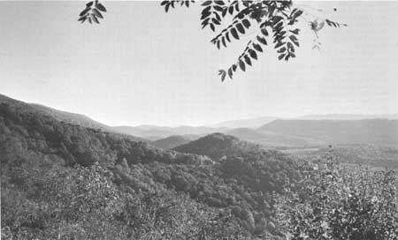
| An Allegheny Parkway would reveal West Virginia's mountain scenery to millions of motorists. |
RECOMMENDATIONS
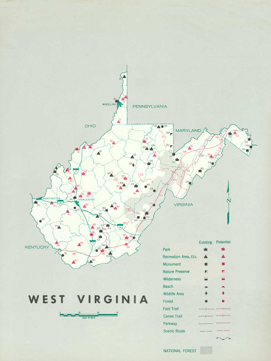
Existing recreation resources and many potential areas are shown on the accompanying tabulation and map. The following program, which will need vigorous action on the part of the agencies concerned, is recommended to help provide additional outdoor recreation opportunities in West Virginia.
NATIONAL: Make a study of the feasibility of an Allegheny Parkway extending from Hagerstown, Md., to Cumberland Gap National Historical Park.
STATE: Enlargement of the State park and recreation system to protect more adequately areas of outstanding scenic, scientific, historic, or archeologic interest. Four parks are recommended and one monument is suggested for further study.
Establishment of additional areas of high recreation potential to supplement the natural areas. Five areas are recommended and five are suggested for further study.
Designation and protection of segments of rivers as canoe trails. Three such trails are recommended for study to initiate this program.
Preservation of segments of rivers in their natural condition as free-flowing streams. Two such streams are recommended for study.
Designation of recreation routes and scenic drives for the enjoyment and edification of residents and visitors alike. Six scenic routes are suggested.
LOCAL: Institution and expansion of out-of-city park systems and programs to incorporate areas of scenic, scientific, and historic interest. Thirteen areas are recommended, and four additional areas are suggested for further Study.
Supporting recommendations include—
1. Northeastern West Virginia studied to identify additional areas of exceptional quality for possible establishment as State parks.
2. Designation and appropriate development as recreation areas of approximately 1,000 acres each in Cabwaylingo, Camp Creek, Cooper's Rock, Greenbrier, Kanawha, Panther, and Seneca State Forests.
3. Designation and maintenance in their primitive state of Calvin W. Price and Kumbrabow State Forests as nature preserves.
(Table omitted from online edition)
|
| (click on image for an enlargement in a new window) |
NEXT >>>
 Top
Top
|
|
Last Modified: Mon, Sep 6 2004 10:00:00 pm PDT
parks_america/west_virginia.htm