.gif)
Parks for America
MENU
![]() Findings and Recommendations
Findings and Recommendations
|
Parks for America
|

|
WISCONSIN
WISCONSIN has an abundance of outdoor recreation resources attributable primarily to glacial action, the effects of which are in evidence throughout a major portion of the State.
|
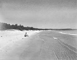
| Beach and dunes make the Whitefish Bay area a valuable recreation resource for Wisconsin. |
The State has experienced an increase of over one-half million in population in the last decade, and projections indicate that the population will further increase from 3,951,777 in 1960 to 5,131,000 by 1976. In 1960, about 63 percent of the population was urban, an increase of 27 percent since 1950. Density ranges from 7 per square mile in Florence County to 4,335 in Milwaukee County. There are 5 metropolitan areas of over 100,000 people in the State.
The vacation and tourist industry amounted to $581 million in the fiscal year 1959-60. Slightly more than 50 percent of this revenue was from nonresidents. About 3,690,000 nonresidents spent at least part of their vacation in Wisconsin.
Bus and airline transportation bring in some vacationists, but the majority of recreation travel is by automobile. The Interstate Highway System will facilitate the movement of recreation-bent people from Chicago and urban centers in the southeastern part of the State toward the northwestern lakes region.
Relatively cool summers plus varied and abundant recreation resources make the State an important summer vacation region in the Midwest. Winter conditions are excellent for all types of winter sports.
The primary natural resources include Lake Michigan, Lake Superior, and Green Bay; the Great North Woods, encompassing thousands of lakes and ponds and 3,967,000 acres of National, State, and county forests; also numerous other lakes, rivers, and streams scattered throughout the State. There are a number of historic and prehistoric sites of which the Oconto Site and Prairie du Chien possess exceptional value in commemorating the history of the United States.
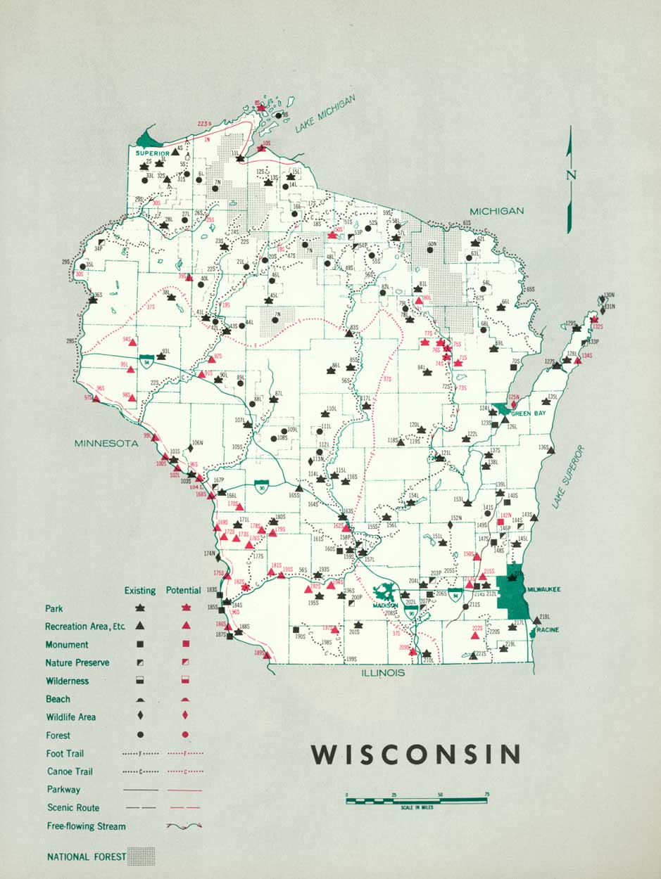
EXISTING PUBLIC AREAS
NATIONAL: The Forest Service administers two national forests totaling 1,467,515 acres in which there are several small recreation areas. Seven national wildlife refuges, comprising 149,228 acres, are administered by the Bureau of Sport Fisheries and Wildlife.
STATE: The Forests and Parks Division administers 30 parks and recreation areas, totaling 22,391 acres, and 11 historic sites. The combined attendance in 1960 was 5,289,926.
The Division also administers 9 forests totaling 366,409 acres, with a visitation of 976,883 in 1960. Only the major forests are plotted on the map. The Fish and Game Management Division administers 149 fish and game management areas totaling 183,032 acres and some 648 fishing access sites. Approximately 182 waysides are under the Department of Highways.
LOCAL: There are 27 county forests covering 2,201,786 acres, and 181 county park and recreation areas with a total of 35,219 acres. The major county forests with developed recreation areas are plotted on the map.
PRIVATE ENTERPRISE: Privately financed recreation accommodations and services are extremely important to vacationers. Cabins, boat rentals, guide services, etc., provided in the northern lake country are almost exclusively privately owned and operated.
PARK AND RELATED NEEDS
Shorelands of Lake Michigan, Green Bay, and Lake Superior require immediate attention aimed at acquiring and providing for park or related recreation use where such action is merited.
The timberland and lake regions should be extensively preserved in order to maintain the North Woods atmosphere for which northern Wisconsin is famous. Several free-flowing streams should be considered for preservation in their natural state. Day and weekend use facilities are needed in the populous southeastern portion of Wisconsin. Study should be given to the possibility of establishing recreation roads or parkways northward from the proposed Interstate Route 90 into the vacation area of northern Wisconsin.
Existing State parks and forests provide approximately 101,145 acres, and local parks and forests provide 63,802 acres developed and used primarily for recreation. Additional lands are needed to protect the recreation resources and provide adequate public recreation areas. Potential areas identified in this plan total 125,735 acres of State significance and 1,393 acres of local significance. In addition other areas should be selected and developed to provide well-distributed and adequate State and local parks by 1976.
About 55,000 acres of existing State and county forest lands have the potential for providing increased recreation through development and access.
Except for day and weekend use facilities in the populous southeastern portion, Wisconsin's most important recreation need is to provide for vacationists. Revenues for the State's 10-year recreation and resource development program should help substantially in this respect.
|
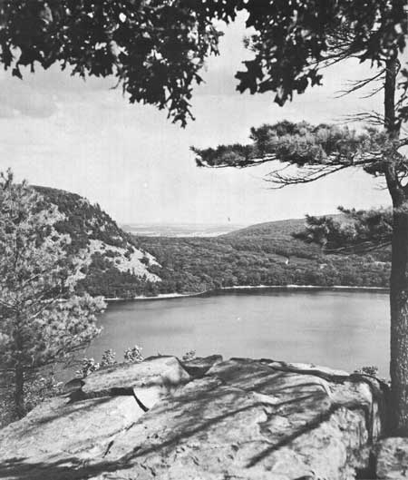
| Continental glaciation formed beautiful Devils Lake. Here an existing State park and additional lands are highly suitable for inclusion in a proposed Ice Age National Scientific Reserve of glacial evidences in Wisconsin. (WISCONSIN CONSERVATION DEPARTMENT.) |
RECOMMENDATIONS
Existing recreation resources and many potentia] areas are shown on the accompanying tabulation and map. Action on the following recommendations is urged so that they can help provide needed outdoor recreation opportunities for public enjoyment and use.
NATIONAL: Establishment of an Ice Age National Scientific Reserve representing continental glaciation features in Wisconsin.
Study of potentialities for a Lake Superior Parkway extending from Superior, Wis., to Sault St. Marie Mich. Approximately 145 miles of such a parkway would pass through northern Wisconsin.
STATE: Expansion of the State park system by the addition of 4 parks and 10 recreation areas and additions to 18 existing areas. Also, further study of 26 other potential parks and recreation areas.
Designation and protection of free-flowing streams such as the Bois Brule, Flambeau, Namekagon, St. Croix, and Wolf Rivers, for recreation.
Establishment of a foot trail along the entire length of the end moraine through Wisconsin on standards similar to those of the Appalachian Trail.
Continuation of progress toward establishing the Great River Road.
LOCAL: Further study on the establishment of five recreation areas.
Supporting recommendations include—
1. Protection of the most scenic river valleys and highway routes either by zoning or purchasing scenic easements.
2. Similar protection for large timber and lake regions where they are not included in existing publicly owned and protected areas.
(Table omitted from online edition)
|
| (click on image for an enlargement in a new window) |
NEXT >>>
 Top
Top
|
|
Last Modified: Mon, Sep 6 2004 10:00:00 pm PDT
parks_america/wisconsin.htm