|
Pinnacles National Park California |
|
 NPS photo | |
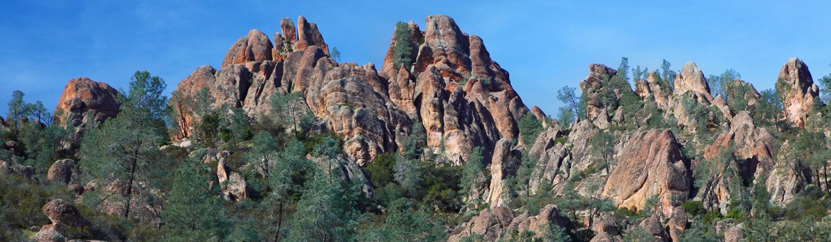
Pinnacles National Park offers an unexpected refuge—for people, animals, and plants. Just a short distance from urban activity, it is a wild place surrounded by rural working landscapes. The park's namesake pinnacles reach toward the sky in stark contrast to rolling hills. These remnants from distant volcanoes create a striking, varied landscape that has attracted people for thousands of years and supports diverse life. It is rugged country, full of opportunities for exploration, escape, and wonder. Which will you choose?
Pinnacles National Park ofrece un refugio inesperado para gente, animales y plantas. A poca distancia de la actividad urbana es un lugar silvestre rodeado de paisajes funcionales y rurales. Los pináculos homónimos del parque alcanzan hacia el cielo en contra de los cerros ondulados. Los remanentes de un volcán distante crean un paisaje variado y deslumbrante que ha atraído gente por miles de años y soporta una amplia vida diversa. Es terreno escabroso lleno de oportunidades para explorar, escapar y pensar. ¿Cual elegirás?
Blended Heritage
PEOPLE HAVE COME HERE for millennia, drawn by the grandeur of the pinnacles. They sought resources, a home, adventure.
Native people harvested abundant plants and hunted wild animals. They used fire to increase plant yield for basket-weaving and many other purposes. In the late 1700s and early 1800s they were decimated by diseases unwittingly brought by the Spanish when they colonized Alta (Upper) California. Survivors were forced to assimilate, convert to Christianity, and live in mission compounds.
In the late 1800s homesteaders built farms in the valleys. The area's spectacular geologic features tempted settlers to come play. Homesteader Schuyler Hain gave tours of Bear Valley and the caves. He ran a grassroots campaign to protect the area, eventually leading President Theodore Roosevelt to establish Pinnacles National Monument in 1908. From 1933 to 1942 Civilian Conservation Corps (CCC) workers built facilities and improved trails. You can still find their work in the Bear Gulch area and stone work on many park trails. Pinnacles became a national park in 2013.
Stewardship continues today with the help of partners. Amah Mutsun Tribal Band and Chalon Indian Nation members participate in habitat-restoration projects. Ranchers and other landowners help protect the entire region, which aids in the preservation of Pinnacles National Park. What will you do to help?
Herencia Combinada
LA GRANDEZA DE LOS pináculos ha atraído gente por milenios. La gente buscaba recursos, aventura y un hogar.
La población nativa cosechaba plantas abundantes y cazaban animales silvestres. Tenían muchos usos para el fuego, por ejemplo, usaban fuego para incrementar la cosecha de plantas para la cestería. A finales de 1700 y principios de 1800 ellos fueron diezmados por enfermedades traídas inconscientemente por los españoles cuando colonizaron a Alta California. Sobrevivientes se vieron obligados a asimilarse, convertirse al cristianismo y vivir en complejos misioneros.
A finales de 1800, homesteaders (granjeros) construyeron granjas en los valles. Las características espectaculares de la zona motivaron a los granjeros a explorar y recrear en la zona. Homesteader Schuyler Hain daba recorridos por Bear Valley y las cuevas. El dirigió una campaña para proteger la área, lo que finalmente llevó al presidente Theodore Roosevelt a establecer el Monumento Nacional Pinnacles en 1908. De 1933 a 1942, los trabajadores del Civilian Conservation Corps (Cuerpo Civil de Conservación, CCC) construyeron instalaciones y mejoraron senderos. Todavía puedes encontrar su trabajo en el área de Bear Gulch y el trabajo de piedra en muchos senderos del parque. Pinnacles se convirtió en parque nacional en 2013.
La buena administración del parque nacional continúa hoy con la ayuda de socios. Los miembros de Amah Mutsun Tribal Band y Chalon Indian Nation participan en proyectos de restauración del hábitat. Los rancheros y otros terratenientes ayudan a proteger toda la región, lo que ayuda a preservar Pinnacles National Park. ¿Qué hará usted para ayudar?
Rocky cliffs, chaparral, native grasslands, and oak savannas harbor a remarkable collection of life. Talus caves shelter Townsend's big-eared bats, while 13 other bat species roost in rock crevices and trees. The park is home to 30 species of reptiles and amphibians. With over 500 species of bees, the park has some of the highest bee diversity known anywhere on Earth.
Endangered California condors, once down to 27 individuals, soar again over the High Peaks. The park is within their historic home range—Amah Mutsun stories tell how the wasaka (condor) escorted spirits of deceased relatives to the next world across the sea. Pinnacle is one of six release sites for captive-bred birds. Today North America's largest land bird nests here. Condor numbers are increasing, but they are not out of danger yet.
Barrancos rocosos, chaparral, pastizales nativos y sabanas de roble albergan una notable colección de vida. Las cuevas de talus albergan a los Townsend's big-eared bats (murciélagos de orejas grandes de Townsend), mientras que otras 13 especies de murciélagos se posan en grietas de rocas y árboles. El parque nacional es hogar para más de 30 especies de reptiles y anfibios. Con más de 500 especies de abejas, el parque nacional tiene una de las mayores diversidades de abejas conocidas en cualquier parte del mundo.
Los cdores de California estan en peligro de extinción, una vez solo se encontraban 27 individuos, ahora se elevan de nuevo sobre los High Peaks. El parque nacional está dentro de su área histórica. Historias de Amah Mutsun cuentan cómo el wasaka (cóndor) guiaba espíritus de familiares fallecidos al otro mundo a través del mar. Pinnacles es uno de los seis sitios de liberación de cóndores criados en cautividad. Hoy las aves terrestres más grandes de Norteamérica anidan aquí. Las cifras de cóndores están aumentando, pero aún no están fuera de peligro.
Powerful Forces at Work
Evidence of nature's power surrounds you here. The rocks are two-thirds of an ancient volcanic field; the remaining third is found 195 miles to the southeast. This split occurred as the Pacific Plate moved north along the San Andreas Fault, creating the Pinnacles Formation. The Neenach Formation was left behind. Weather, water, and wind shaped these rocks, formed 23 million years ago, into distinctive spires and towers.
Boulders fell from cliffs and wedged in slot canyons below, forming talus caves. With cooler temperatures and sometimes precious running water, the caves shelter unique species and beckon the adventurous.
Fuerzas Poderosas en Acción
La evidencia del poder de la naturaleza te rodea aquí. Las rocas son dos tercios de un antiguo campo volcánico. El tercio restante se encuentra a 195 millas al sureste. Esta división ocurrió cuando la Placa del Pacifico se movió hacia el norte a lo largo de la Falla de San Andrés, creando la Formación de Pinnacles. La Formación Neenah quedó atrás. El clima, el agua y el viento dieron forma a estas rocas, formándose hace 23 millones de años, en picos y torres distintivas.
Las grandes rocas cayeron de los acantilados y se encajaron en cañones de ranura que se encontraban debajo, formando cuevas de talus. Con temperaturas más frescas y a tiempos aguas corrientes, las cuevas albergan especies únicas que atraen a los aventureros.
Wild Country
Step into the wilderness for an entirely different experience. Look up at the night sky for stunning views of the Milky Way. Listen to wind funneling through canyons or tickling native grasses. Enjoy vistas of otherworldly spires, enticing crags, and shrub-covered hills. Congress has protected 16,000 acres (65 percent) of Pinnacles National Park as wilderness under the 1964 Wilderness Act. Here you can get away, find solitude and peace, or challenge yourself in the spirit of adventure that has been part of this area for so long.
Paisaje Silvestre
Pise en las tierras silvestres para una experiencia completamente diferente. Mira hacia el cielo nocturno para disfrutar de unas impresionantes vistas de la Vía Láctea. Escuché el viento atravesar los cañones y pasar ligeramente sobre las hierbas nativas. Disfrute de vistas de torres de otro mundo, barrancos y colinas cubiertas de arbustos. El Congreso ha protegido 16,000 acres (65 por ciento) de Pinnacles National Park como áreas silvestres bajo la 1964 Wilderness Act. Aquí puedes escaparte, encontrar la soledad y la paz o desafiarse en el espíritu de la aventura que ha sido parte de esta área durante tanto tiempo.
Explore Pinnacles
NO ROAD CONNECTS THE WEST AND EAST ENTRANCES OF THE PARK. The shortest route from one side to the other is through King City on US 101.
Find lodging, camping, food, and gas in nearby towns. In the park, camp only in the designated campground.
WEST SIDE
Entrance open 7:30 am to 8 pm. Take US 101 to CA 146 and follow signs to
the park. WARNING: CA 146 from Soledad is steep and narrow. RVs,
trailers, and large vehicles should avoid this entrance.
WEST VISITOR CONTACT STATION Find exhibits, information, a film, and a bookstore. Open year-round. Schedule varies; check the website.
EAST SIDE
Entrance open 24 hours; no overnight parking except in campground. Take
CA 25 to East Entrance Road.
BEAR GULCH NATURE CENTER Find exhibits, information, and a film. Open seasonally. Schedule varies; check the website.
PINNACLES CAMPGROUND Open year-round. The campground has tent, RV, and group sites; tent cabins; hookups; and showers. Reserve at www.recreation.gov or call 877-444-6777.
STORES Camp store: Open 9:30 am to 5 pm daily. Park store: Find books, maps, educational souvenirs, and more. Schedule varies; check the website.
ACTIVITIES
Some of the park's most popular activities are listed here. Check the
website for more things to do.
BIRDING Over 180 species are found here. Look for California condors and peregrine and prairie falcons in the High Peaks area.
CAVE EXPLORATION Balconies and Bear Gulch caves offer a respite from the heat. Be prepared for low ceilings, uneven footing, and scrambling over rocks. Use a flashlight or headlamp. Bear Gulch Cave is closed seasonally to protect bat colonies. Check the website for current closures.
CLIMBING Explore hundreds of climbing routes from easy to extremely difficult. Check the website for safety and general information. Use climbing guides for route descriptions and grades.
RANGER PROGRAMS Programs are offered seasonally. Check the website for schedules.
HIKING Over 30 miles of trails range from easy to difficult. Carry and drink at least one liter of water per person per hour.
ACCESSIBILITY We strive to make facilities, services, and programs accessible to all. For information go to the contact station or nature center, ask a ranger, call, or check the park website.
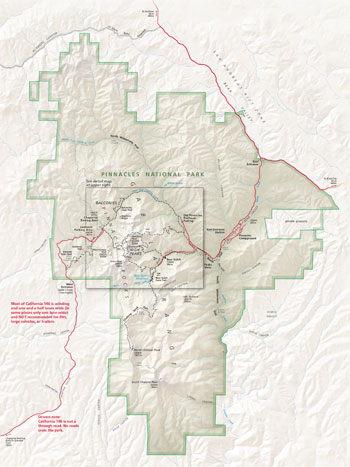  (click for larger maps) |
Explorar Pinnacles
NINGUNA CARRETERA CONECTA ENTRADAS OESTE Y ESTE DEL PARQUE NACIONAL. La ruta mas corta de un lado al otro es a través de King City por el US 101.
Encuentran alojamiento, sitios de campamento, comida y gasolina en las ciudades cercanas. En el parque nacional, acampe sólo en el área designada de campamento.
EL LADO OESTE
La entrada está abierta de las 7:30 hasta las 20:00. Tome la autopista
US 101 a CA 146 y siga las indicaciones hacia el parque. ADVERTENCIA:
CA 146 desde Soledad es empinada y estrecha. Los vehículos recreativos,
campers, remolques y vehículos grandes deben evitar esta
entrada.
ESTACIÓN DE CONTACTO PARA VISITANTES DEL OESTE Encuentran exhibiciones, información, una película informativa del parque y una librería. Abierto todo el año. El horario varía; consulte el sitio web.
EL LADO ESTE
Abierto las 24 horas. No se permite estacionamiento durante la noche
excepto en el área de campamento. Tome CA 25 hasta East Entrance
Road.
BEAR GULCH NATURE CENTER Encontrará exhibiciones, información y una película informativa del parque. Solo abierto en temporadas. El horario varia; consulte el sitio web.
PINNACLES CAMPGROUND Abierto todo el año. El sitio de campamento tiene áreas para RVs, carpas de acampar, sitios para grupos, cabanas de carpa, conexiones, y duchas. Reserve en www.recreation.gov o llame al 877-444-6777. Para obtener información, llame al 831-200-1722.
TIENDAS Camp Store: Abierta de 9:30 am a 17:00 diariamente. Park Store: Encuentra libros, mapas, recuerdos educativos, y más. El horario varía; consulte el sitio web.
ACTIVIDADES
Algunas de las actividades más populares del parque nacional se enumeran
aquí. Consulte el sitio web para ver más actividades.
OBSERVACIÓN DE AVES Más de 180 especies se encuentran aquí. Busque los California condors, halcónes peregrinos y halcones de pradera en el área de High Peaks.
EXPLORACIÓN DE CUEVAS Las cuevas Balconies y Bear Gulch brindan un respiro del calor. Esté listo para techos bajos, equilibrio desigualado y escalado sobre rocas. Utilice una linterna o un faro. La cueva Bear Gulch está cerrada por temporadas para proteger las colonias de murciélagos. Visite el sitio web para cierres actuales.
MONTAÑISMO Explora cientos de rutas de escalada de fácil a extremadamente difícil. Consulte el sitio web para obtener información general y de seguridad. Utilice guías de escalada para las descripciones y grados de las rutas.
PROGRAMAS DE GUARDAPARQUES Los programas se ofrecen por temporada. Consulte el sitio web para ver los días de programación.
EXCURSIONISMO Sobre las 30 millas de senderos varían de dificultad. Se recomienda llevar al menos dos litros de agua por persona.
ACCESIBILIDAD Intentamos hacer nuestras infraestructuras, servicios y programas accesibles para todos. Para obtener información, diríjase a la estación de contacto o al centro de naturaleza, pregúntele a un guardaparques, llame o consulte al sitio web del parque nacional.
Safety and Regulations
Be prepared. Cell phone service is limited. In summer and fall daytime temperatures can reach over 100°F. Check the website for more safety information and regulations.
Carry and drink plenty of water. • Wear loose-fitting clothing, a hat, and sunscreen. • Wear sturdy, non-slip shoes or boots with ankle support. • Be careful where you sit, step, and place your hands: Poison oak, stinging nettles, and rattlesnakes are found here. • Pets and bicycles are prohibited on all trails. • Feeding, approaching, or hunting wildlife is prohibited. • Federal laws protect all natural and cultural features in the park. • For firearms regulations check the park website. • Using remotely piloted aircraft like drones is prohibited.
Seguridad y Regulaciones
Estén preparados. El servicio de telefonía celular es limitado. En verano y otoño las temperaturas pueden alcanzar más de 100°F. Consulte el sitio web para obtener más información y regulaciones de seguridad.
Lleve y beba mucha agua. • Use ropa holgada, un sombrero y protector solar. • Use zapatos o botas resistentes y antideslizantes con soporte para el tobillo. • Tenga cuidado donde se sienta, pisa y coloca las manos. Aquí se encuentran robles venenosos, ortigas y serpientes de cascabel. Las mascotas y bicicletas están prohibidas en todos los senderos. • Está prohibido alimentar, acercarse o cazar vida silvestre. • Las leyes federales protegen todas las características naturales y culturales del parque. • Para conocer las regulaciones de armas de fuego, consulte el sitio web del parque nacional. • El uso de aeronaves pilotadas remotamente como drones está prohibido.
Source: NPS Brochure (2023)
Hiking
| East Side Trails | |
|---|---|
Pinnacles Visitor Center to Bear Gulch day use area 2.3 miles one way, 1½ hours elevation gain: 300 feet |
Moderate Walk along Chalone and Bear creeks from the Pinnacles Visitor Center to
the Bear Gulch day use area. Portions of the Bench Trail are accessible to visitors in
wheelchairs. |
South Wilderness Trail 6.5 miles round trip, 3 to 4 hours no elevation gain |
Moderate Follow this unmaintained frail to the park boundary, or simply meander
through the magnificent grove of valley oaks. Begin at the campground and follow
the Bench Trail to the South Wilderness marker. |
Pinnacles Visitor Center to Balconies Cave 9.4 miles round trip, 3 to 4 hours elevation gain: 300 feet |
Moderate Hike along sunny Chalone Creek on the Bench and Old Pinnacles trails to
Balconies Cave. On the return trip, cress over the cave via the Balconies Cliffs for
views of formations. Flashlight required in cave. |
Moses Spring-Rim Trail Loop 2.2-mile loop, 1½ hours elevation gain: 500 feet |
Moderate This loop is a good choice for rock formations, talus caves, and the
reservoir on a short hike and also a good choice for children. Bear Gulch Cave is
open seasonally. Flashlight required in cave. |
Condor Gulch-High Peaks Loop 5.3-mile loop, 3 to 5 hours elevation gain: 1,300 feet |
Strenuous Walk through the heart of the Pinnacles rock formations, particularly
along the Steep and Narrow section of the High Peaks Trail. Add the Rim and Moses
Spring trails to extend the loop to 6.1 miles. |
High Peaks-Bear Gulch Loop 6.7-mile loop, 4 to 5 hours elevation gain: 1,425 feet |
Strenuous Climb into the High Peaks and descend along the ridge through meadows
of grasses and, in spring, wildflowers. Return to the Bear Gulch area under the
shade of sycamores along the Bear Gulch Trail. |
Condor Gulch Trail 1.7 miles one way, 1 to 1½ hours elevation gain: 1,100 feet |
Moderate to overlook, strenuous beyond This trail offers spectacular views of the
High Peaks, whether you hike just a few minutes or the entire trail. The overlook is
one mile up. |
Chalone Peak Trail 9 miles round trip, 3 to 5 hours elevation gain: 2,040 feet |
Strenuous Climb to the highest point in the park. North Chalone Peak, and be
rewarded with views of the surrounding valleys. Continue on an unmaintained trail
to South Chalone Peak for a longer hike. |
Old Pinnacles Trail to Balconies Cave 5.3 miles round trip, 4 to 5 hours no elevation gain |
Moderate This sunny hike to Balconies Cave also leads to the towering rock
formations of Machete Ridge and the Balconies Cliffs. Begin at the Old Pinnacles
Trailhead. Flashlight required in cave. |
West Side Trails | |
Balconies Cliffs-Balconies Cave Loop 2.4-mile loop, 1 to 1½ hours elevation gain: 100 feet |
Easy to Moderate This trail through Balconies Cave may require a bit of scrambling
through talus passages. Wading may be required in winter. Flashlight required in
cave. |
Juniper Canyon Loop 4.3-mile loop, 2 to 3 hours elevation gain: 1,215 feet |
Strenuous This steep trail climbs along switchbacks to the heart of the High Peaks.
At the top, circle through the rock formations along the Steep and Narrow section
of the High Peaks Trail and the Tunnel Trail. |
North Wilderness Trail Loop 9.3-mile loop, 5 to 8 hours elevation gain: 1,020 feet |
Strenuous This unmaintained trail climbs along ridgetops and then descends into
the Chalone Creek bed, where it is marked by rock cairns. Return along the Old
Pinnacles and Balconies trails. |
High Peaks-Balconies Cave Loop 8.4-mile loop, 4 to 5 hours elevation gain: 1,540 feet |
Strenuous Begin by climbing into the High Peaks, and the rest of the loop is
downhill or flat. Return along the Old Pinnacles and Balconies trails, going over or
through the cave. Flashlight required in cave. |
Source: NPS Brochure (2016)
|
Establishment
Pinnacles National Park — January 10, 2013 |
For More Information Please Visit The  OFFICIAL NPS WEBSITE |
Documents
A Favorable Report on the Creation of a National Monument on the Site of the Pinnacles Rocks California (George W. Peavy, September 9, 1907)
A Guide to the Plants of the Pinnacles (Ralph C. Webb, September 1971)
Accessibility Self-Evaluation and Transition Plan Overview, Pinnacles National Park, CA (March 2016)
Administrative History of Pinnacles National Monument (Reta R. Oberg, 1979)
Aqueous Geochemistry of Waters and Hydrogeology of Alluvial Deposits, Pinnacles National Park, California U.S. Geological Survey Open-File Report 2022-1026 (Kathleen Scheiderich, Claire R. Tiedman and Paul A. Hsieh, 2022)
Botanical Inventory of Pinnacles National Monument’s New Lands: A Volunteer Botany Inventory NPS Natural Resource Report NPS/PWR/SFAN/NRTR—2008/083 (Andrea Williams, January 2008)
Butterfly Checklist, Pinnacles National Park (February 13, 2015)
California Condor Reestablishment Program Annual Reports: 2009 • 2010 • 2011 • 2012 • 2013 • 2014 • 2015 • 2016 • 2017 • 2018 • 2019 • 2020 • 2021 • 2022
Camper Study: Spring 2013, Pinnacles National Park NPS Natural Resource Report NPS/NRSS/EQD/NRR-2014/750 (Marc F. Manni and Yen Le, January 2014)
Cultural Landscapes Inventory: Bear Valley School, Pinnacles National Park (2020)
Cultural Landscapes Inventory: Ben Bacon Ranch Historic District, Pinnacles National Monument (2009)
Cultural Landscapes Inventory: High Peaks Trail System, Pinnacles National Monument (2009)
Cultural Landscapes Inventory: Pinnacles East Entrance District, Pinnacles National Monument (2002)
Decades of native bee biodiversity surveys at Pinnacles National Park highlight the importance of monitoring natural areas over time (Joan M. Meiners, Terry L. Griswold and Olivia Messinger Carril, PLoS ONE, 14(1), January 17, 2019)
Development Concept Plan and Environmental Assessment: East District, Pinnacles National Monument, California (October 1993)
Development Concept Plan and Environmental Assessment: West District, Pinnacles National Monument, California (January 1991)
Draft General Management Plan and Environmental Assessment, Pinnacles National Monument (October 2012)
Final Report on the Digitization of Historic 1930's Wieslander Vegetation Type Maps for Pinnacles National Monument (James H. Thorne, October 13, 2010)
Fire and Water: Environmental History of Pinnacles National Monument (Timothy Babalis, extract from Proceedings of the 2009 George Wright Conference, 2010)
Fire Management Plan Environmental Assessment, Pinnacles National Monument (April 2005)
Foundation Document, Pinnacles National Park, California (January 2015)
Foundation Document Overview, Pinnacles National Park, California (March 2015)
Geologic Map of Pinnacles National Park (2022)
Geologic Resources Inventory Report, Pinnacles National Park NPS Natural Resource Report NPS/NRSS/GRD/NRR-2022/2471 (Michael Barthelemes, October 2022)
Geology of the Pinnacles National Monument University of California Publications Bulletin of the Department of Geological Sciences Volume 24, No. 1 (Philip Andrews, September 22, 1936)
Geology and Road Log of Pinnacles National Monument (HTML edition) (Norman E.A. Hinds, extract from Mineral Information Service, Vol. 21 No. 8, August 1968, ©California Department of Conservation)
Ground-Water Reconnaissance at Pinnacles National Monument, California USGS Water-Supply Paper 1475-K (R.E. Evenson, 1962)
Impacts of Visitor Spending on the Local Economy: Pinnacles National Park, 2013 NPS Natural Resource Report NPS/NRSS/EQD/NRR—2014/826 (Philip S. Cook, July 2014)
Invasive Plant Species Early Detection
Invasive Plant Species Early Detection in the San Francisco Bay Network: 2011 Annual Report NPS Natural Resource Technical Report NPS/SFAN/NRTR-2012/620 (Eric Wrubel and Robert Steers, September 2012)
Invasive Plant Species Early Detection in the San Francisco Bay Network: 2012 Annual Report NPS Natural Resource Technical Report NPS/SFAN/NRTR-2013/797 (Eric Wrubel and Robert Steers, September 2013)
Invasive Plant Species Early Detection in the San Francisco Bay Network: 2013 Annual Report NPS Natural Resource Data Series NPS/SFAN/NRDS-2015/758 (Eric Wrubel, February 2015)
Invasive Plant Species Early Detection in the San Francisco Bay Network: 2014 Annual Report NPS Natural Resource Data Series NPS/SFAN/NRDS-2017/1080 (Eric Wrubel, January 2017)
Invasive Plant Species Early Detection in the San Francisco Bay Network: 2015 Annual Report NPS Natural Resource Data Series NPS/SFAN/NRDS-2017/1123 (Eric Wrubel and Raphaela E. Floreani Buzbee, October 2017)
Invasive Plant Species Early Detection in the San Francisco Bay Network: 2016 Annual Report NPS Natural Resource Data Series NPS/SFAN/NRDS-2018/1159 (Eric Wrubel and Raphaela E. Floreani Buzbee, April 2018)
Invasive Plant Species Early Detection in the San Francisco Bay Network: 2017 Annual Report NPS Natural Resource Data Series NPS/SFAN/NRDS-2019/1198 (Eric Wrubel and Nick Graver, January 2019)
Invasive Plant Species Early Detection in the San Francisco Bay Network: 2018 Annual Report NPS Natural Resource Data Series NPS/SFAN/NRDS-2019/1211 (Eric Wrubel, March 2019)
Junior Ranger, Pinnacles National Park (2013; for reference purposes only)
Long-Range Interpretive Plan, Pinnacles National Monument (April 2004)
Map: Pinnacles National Monument (1940)
Mineral Resources of the Pinnacles Wilderness Contiguous Wilderness Study Area, Monterey and San Benito Counties, California U.S. Geological Survey Bulletin 1705-C (Steve Ludington, Karen Gray and Lucia Kuizon, 1987)
Museum Management Plan: Pinnacles National Monument (October 2005)
National Register of Historic Places Nomination Form
Bear Valley School (Timothy Babalis, September 24, 2013; Designation: June 2, 2014)
Chalone Creek Archaeological Sites (Roger E. Kelly, July 10, 1975; Designation: November 14, 2022)
Harrison Lyons Homestead Historic District (Designation: August 15, 2016)
Pinnacles National Park Roads (Designation: November 14, 2022)
Natural History of the Pinnacles National Monument (Ralph C. Webb, ed., 1969)
Natural Resource Condition Assessment, Pinnacles National Monument NPS Natural Resource Report NPS/PINN/NRR-2013/709 (Frank W. Davis, David M. Stoms and Patrick A. Jantz, September 2013)
Natural Resources Management Plan and Environmental Assessment, Pinnacles National Monument, California (April 1976)
Natural Resources Planning and Management in the National Park Service — Pinnacles National Monument (Kathleen M. Davis, extract from Proceedings of the Symposium on Dynamics and Management of Mediterranean-Type Ecosystem, General Technical Report PSW-58, June 1982)
Notes on the History of Pinnacles National Monument (Olaf T. Hagen, April 28, 1941)
Petrochemical Studies of the Pinnacles Wilderness Contiguous Wilderness Study Area, Monterey and San Benito Counties, California U.S. Geological Survey Open-File Report 87-135 (Steve Ludington and Karen Gray, 1987)
Pinnacles Vascular Plant List (2014)
Potential hazards from flood in part of the Chalone Creek and Bear Valley drainage basins, Pinnacles National Monument, California USGS Open-File Report 95-426 (Robert W. Meyer, 1995)
Proposed Master Plan/Final Environmental Statement, Pinnacles National Monument, California (1975)
Prairie Falcon Monitoring Protocol for Pinnacles National Park: Narrative — Version 2.3 NPS Natural Resource Technical Report NPS/SFAN/NRR-2011/466 (Gavin Emmons, Jim Petterson, Marcus Koenen and David Press, November 2011)
Prairie Falcon Monitoring Protocol for Pinnacles National Park: Standard Operating Procedures — Version 2.3 NPS Natural Resource Technical Report NPS/SFAN/NRR-2011/466 (Gavin Emmons, Jim Petterson, Marcus Koenen and David Press, November 2011)
Prairie and Peregrine Falcon Occupancy and Productivity Monitoring
2000 Breeding Season Report for Pinnacles National Monument (Kelly D. Ward, 2000)
2001 Breeding Season Report for Pinnacles National Monument (Betty Hayes and Amy Fesnock, 2001)
2002 Raptor Breeding Season Report for Pinnacles National Monument (Ben Kinkade, 2002)
2003 Raptor Breeding Season Report for Pinnacles National Monument (Gavin Emmons, 2003)
2004 Raptor Breeding Season Report for Pinnacles National Monument (Gavin Emmons, 2004)
2005 Raptor Breeding Season Report for Pinnacles National Monument (Gavin Emmons, 2005)
Raptor Breeding Season Report for Pinnacles National Monument — 2006 (Gavin Emmons, September 2006)
Raptor Breeding Season Report for Pinnacles National Monument — 2007 NPS Natural Resource Technical Report NPS/SFAN/NRTR-2008/087 (Gavin Emmons, January 2008)
Raptor Breeding Season Report for Pinnacles National Monument — 2008 NPS Natural Resource Technical Report NPS/SFAN/NRTR-2009/192 (Gavin Emmons, March 2009)
2011 Breeding Season Report for Pinnacles National Monument — Prairie Falcons and Other Raptors NPS Natural Resource Technical Report NPS/SFAN/NRTR-2012/614 (Gavin Emmons, August 2012)
Prairie and Peregrine Falcon Occupancy and Productivity Monitoring at Pinnacles National Park: 2012 Annual Report NPS Natural Resource Technical Report NPS/SFAN/NRTR-2013/811 (Gavin Emmons, November 2013)
Prairie and Peregrine Falcon Occupancy and Productivity Monitoring at Pinnacles National Park: 2013 Annual Report NPS Natural Resource Technical Report NPS/SFAN/NRTR-2014/892 (Gavin Emmons, July 2014)
Prairie and Peregrine Falcon Occupancy and Productivity Monitoring at Pinnacles National Park: 2014 Annual Report NPS Natural Resource Technical Report NPS/SFAN/NRTR-2014/926 (Gavin Emmons, December 2014)
Prairie and Peregrine Falcon Occupancy and Productivity Monitoring at Pinnacles National Park: 2015 Annual Report NPS Natural Resource Report NPS/SFAN/NRR-2016/1151 (Gavin Emmons, March 2016)
Prairie and Peregrine Falcon Occupancy and Productivity Monitoring at Pinnacles National Park: 2016 Annual Report NPS Natural Resource Report NPS/SFAN/NRR-2017/1379 (Gavin Emmons, January 2017)
Prairie and Peregrine Falcon Occupancy and Productivity Monitoring at Pinnacles National Park: 2017 Annual Report NPS Natural Resource Report NPS/SFAN/NRR-2018/1576 (Gavin Emmons, January 2018)
Prairie and Peregrine Falcon Occupancy and Productivity Monitoring at Pinnacles National Park: 2018 Annual Report NPS Natural Resource Report NPS/SFAN/NRR-2019/1861 (Gavin Emmons, January 2019)
Prairie and Peregrine Falcon Occupancy and Productivity Monitoring at Pinnacles National Park: 2019 Annual Report NPS Natural Resource Report NPS/SFAN/NRR-2020/2018 (Gavin Emmons, February 2020)
Prairie and Peregrine Falcon Occupancy and Productivity Monitoring at Pinnacles National Park: 2020 Annual Report NPS Natural Resource Report NPS/SFAN/NRR-2021/2315 (Gavin Emmons, October 2021)
Prairie and Peregrine Falcon Occupancy and Productivity Monitoring at Pinnacles National Park: 2021 Annual Report NPS Natural Resource Report NPS/SFAN/NRR-2022/2449 (Gavin Emmons, September 2022)
Prairie and Peregrine Falcon Occupancy and Productivity Monitoring at Pinnacles National Park: 2022 Annual Report NPS Natural Resource Report NPS/SFAN/NRR-2023/2502 (Gavin Emmons, March 2023)
Prairie and Peregrine Falcon Occupancy and Productivity Monitoring at Pinnacles National Park: 2023 Annual Report NPS Natural Resource Report NPS/SFAN/NRR-2024/2625 (Gavin Emmons, February 2024)
Presidential Proclamation 7266 — Boundary Enlargement of the Pinnacles National Monument (William J. Clinton, January 11, 2000)
Raptors of the Pinnacles National Monument: Past and Present Nesting and Possible Impacts of Rock Climbers Cooperative National Park Resources Studies Unit Technical Report No. 30 (Margaret Cymerys and B.J. Walton, 1988)
Report of Geotechnical Consultation, Pinnacles National Monument, California (Dames & Moore, October 6, 1976)
Report on Sullys Hill Park, Casa Grande Ruin; the Muir Woods, Petrified Forest, and Other National Monuments, Including List of Bird Reserves: 1915 (HTML edition) (Secretary of the Interior, 1914)
Report on Wind Cave National Park, Sullys Hill Park, Casa Grande Ruin, Muir Woods, Petrified Forest, and Other National Monuments, Including List of Bird Reserves: 1913 (HTML edition) (Secretary of the Interior, 1914)
Results for Geological Survey Investigation at Pinnacles National Monument, Paicines, California (Fred R. Conwell & Associates, August 23, 1993)
Riparian Landbird Monitoring in Pinnacles National Park: Progress Report for 2015 NPS Natural Resource Data Series NPS/SFAN/NRDS-2016/1042 (Mark D. Dettling and Diana L. Humple, August 2016)
Soil Survey of Pinnacles National Monument, California (2008)
Tending the land: Integrating indigenous knowledge into the restoration of a California grassland (Karen Holl, Rick Flores, Brent E. Johnson, Valentin Lopez and Amelia B. Ryan, 2018)
The Geohydrology of Pinnacles National Monument, California USGS Open-File Report 67-2 (J.P. Akers, 1967)
The Heart of the Gabilans: An Administrative History of Pinnacles National Monument (Timothy Babalis, 2009)
The Pinnacles and Their Wonders (W.W. Canfield, extract from Overland Monthly, Vol. LXV, No. 5, June 1915)
The Pinnacles of San Benito County (Schuyler G. Hain, extract from Out West, Vol. XXIII No. 2, August 1905)
Vancouver’s Pinnacles (Donald Macdonald, extract from Sunset Magazine, Vol. XI No. 4, August 1903)
Vasco, the Bandit of the Pinnacles (W.W. Canfield, extract from Overland Monthly, Vol. LXVI No. 5, November 1915)
Vascular Plant Survey: Pinnacles National Monument, California NPS Natural Resource Technical Report NPS/SFAN/NRTR-2008/086 (Sharon Franklet, January 2008)
Vegetation Classification and Mapping Project Report, Pinnacles National Monument NPS Natural Resource Report NPS/SFAN/NRR—2012/574 (G. Kittel, E. Reyes, J. Evens, J. Buck and D. Johnson, September 2012)
Visitor and Vehicular Data Collection (Otak, Inc., December 2003)
Visitor Study: Spring 2013, Pinnacles National Park NPS Natural Resource Report NPS/NRSS/EQD/NRR—2014/766 (Margaret Littlejohn, Marc F. Manni and Yen Le, February 2014)
West Side Trails Construction Environmental Assessment, Pinnacles National Monument (March 2016)
pinn/index.htm
Last Updated: 25-Feb-2025