|
Pictured Rocks National Lakeshore Michigan |
|
 NPS photo | |
Stories in Sand
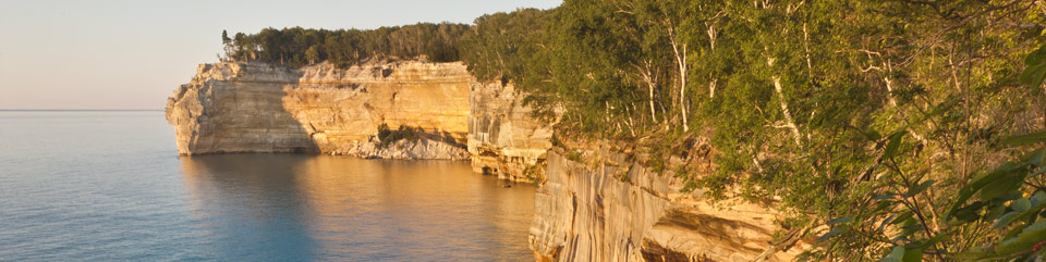
Sandstone cliffs—ochre, tan, and brown with layers of white and green—tower 50 to 200 feet above the water. Vast, blue Lake Superior glistens against a cloud-streaked sky. Deep forests of emerald, black, and gold open onto small lakes and waterfalls. The images are like a painter's work. A palette of nature's colors, textures, and shapes sets the scene at Pictured Rocks National Lakeshore.
This place of beauty was authorized as the first national lakeshore in 1966 to preserve the shoreline, beaches, cliffs, and dunes and to provide an extraordinary place for recreation and discovery. Just over six miles across at its widest point, the park hugs Lake Superior's shoreline for over 40 miles and consists of the Lakeshore Zone, federal land managed by the National Park Service, and the Inland Buffer Zone, a combination of federal, state, and private ownership. Together these nearly 73,000 acres protect some of Lake Superior's shoreline and watershed.
Icy Architects Massive glaciers, inching back and forth over a million years, scoured and molded this land. Moving ice ground volcanic and sedimentary rock from previous eras into rubble and slowly enlarged river valleys into the wide basins that would become the Great Lakes.
The last glacier began retreating about 10,000 years ago. Over time its meltwater formed powerful rivers and scattered rubble onto outwash plains and into crevasses. Water scooped out the basins and channels that harbor wetlands in the park today. Eventually, as the weight of the glacier lessened, the land rose and exposed bedrock to lake erosion. This onslaught by the lake-centuries of crushing ice and battering waves-carved the bedrock into young cliffs. Water continues to pound and sculpt the cliffs, eroding them inland while enlarging the lake.
The force of water, solid or liquid, profoundly altered this landscape and created the world's largest freshwater lake system. It sculpted arches, cliff profiles, and the inland lakes that formed when glacial outwash buried enormous blocks of ice. Melting ice formed depressions that filled with water and became kettle lakes. The stones along Twelvemile Beach are horn coral from an ancient sea, polished granite and quartz rounded like eggs, and disk-shaped fragments of the Jacobsville sandstone.
Colorful Cliffs The name Pictured Rocks comes from the streaks of mineral stain decorating the face of the cliffs. The streaks occur when groundwater oozes out of cracks. The dripping water contains iron, manganese, limonite, copper, and other minerals that leave behind a colorful stain as the water trickles down a cliff face.
The cliffs' ramparts are composed of 500-million-year-old Cambrian sandstone of the Munising Formation, which makes up much of the angled slopes and features like Miners Castle. Closest to lake level is the Jacobsville Formation, a late-Precambrian mottled red sandstone that is the oldest exposed rock in the park. Covering all is the 400-million-year-old Ordovician Au Train Formation, a harder, limy sandstone that serves as a capstone and protects the underlying sandstone from rapid erosion.
Living with Lake and Land
The bounty of the lake and land has attracted people since the glaciers retreated northward. Archaic and Woodland Indians made summer camps along the coast between what is now Munising and Grand Marais. Later, Anishinaabek Indians hunted and fished here, as their descendants still do, while en route to summer fishing areas farther east. Today, little evidence remains within the park of these early people.
European Adventurers
In the 1600s and 1700s European explorers and voyageurs searched here
for furs and minerals. These expeditions give us many of the area's
earliest written accounts and left place names like Miners Castle and
Grand Marais. In the 1800s American and European settlers arrived to
make fortunes in mining and logging.
We had been told of the variety in the colour and form of these rocks, but were wholly unprepared to encounter the surprising groups of overhanging precipices, towering walls, caverns, waterfalls ... mingled in the most wonderful disorder.
—Henry Rowe Schoolcraft,
regional explorer and scholar, 1820
Booming Commerce
The demand for lumber attracted businessmen who bought vast forests of
white pine, beech, and maple. Through the late 1800s boomtowns along
Lake Superior's southern shore supported large logging operations and
blast furnaces that produced pig iron for the nation's growing railroad
industry. By the early 1900s both logging and ironworking had diminished
due to loss of natural resources.
The Life-Saving Era
As businesses flourished, Lake Superior's commercial activity also
increased. To help ships navigate the treacherous rock reef, the US Life
Saving Service and the US Lighthouse Service (later the US Coast Guard)
built lifeboat rescue stations and light stations along the shore.
Remnants of this era still exist in the park.
A Powerful Lake
Measured by surface area, Lake Superior is the world's largest
freshwater lake—350 miles long, 160 miles across, and over 1,300
feet at its deepest point. The lake basin holds so much liquid that, if
drained, it could fill a pool the size of the lower 48 states to a depth
of nearly five feet.
Lake Superior acts like an inland sea, creating powerful storms and exerting a great influence on the surrounding land. Its cold water moderates the climate, keeping summer cooler and winter somewhat warmer. Mist, fog, wind, and lake effect snow affect the park's soil, vegetation, and wildlife and the people who live nearby.
The lake continually reshapes the park's beaches and shoreline. Wave energy and the forces of ice and thaw work on the porous sandstone cliffs, causing erosion that may result in rockfalls.
With each season Lake Superior shows a different mood: summer's gentle waves, autumn's furious storms, or winter's icy stillness.
Plan Your Visit
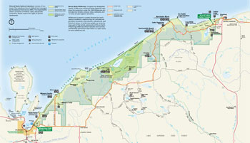 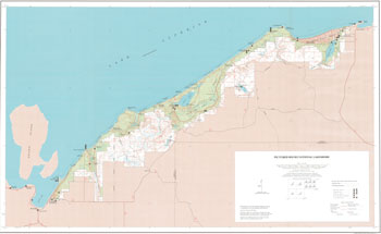 (click for larger maps) |
Pictured Rocks National Lakeshore consists of two zones. The Lakeshore Zone is federal land managed by the National Park Service (NPS). The Inland Buffer Zone is a mixture of federal, state, and private ownership. Please respect the rights of private landowners.
Beaver Basin Wilderness Congress has designated nearly 12,000 acres in Pictured Rocks National Lakeshore for protection under the 1964 Wilderness Act. Included are forests, streams, lakes, wetlands, and 13 miles of Lake Superior shoreline.
Wilderness is meant to protect forever the land's natural conditions, opportunities for solitude and primitive recreation, and scientific, educational, and historical values. In wilderness people can sense being a part of the whole community of life on Earth. Preserving wilderness shows restraint and humility and benefits generations that follow us. Learn more at www.wilderness.net.
Munising Falls Visitor Center is located on the park's western end. Stop here for information, brochures, backcountry permit information, a bookstore, and activity and program schedules. Exhibits explain blast furnace and logging history and the geology of Pictured Rocks cliffs. Enjoy a short walk to Munising Falls. Open daily mid-May to mid-October. Open Thursdays through Saturdays in winter except federal holidays.
Grand Sable Visitor Center, at the foot of Grand Sable Dunes on the park's eastern end, offers information, backcountry permit information, exhibits, and a bookstore. Open daily in summer.
Boat Tours/Trips Concession cruise boats travel from Munising along the Pictured Rocks cliffs daily mid-May to mid-October. For tickets and more information visit www.picturedrocks.com. Various commercial businesses offer kayak trips and other guided recreational opportunities: www.nps.gov/piro/planyourvisit/commercial-services.htm.
Hiking and Walking Pictured Rocks offers 100 miles of trails; choose from short or long, easy or strenuous. Get maps and information at the visitor centers. Portions of the North Country Trail and other trails give you spectacular vistas of the lake, cliffs, dunes, and waterfalls. Plan ahead. Tell someone where you are going. Carry plenty of water and food. Be prepared for rain or rapid weather changes. Wear sturdy footgear and layered clothing.
Beaches Sand beaches on Lake Superior that are suitable for sunbathing and swimming are located at Sand Point, Miners Beach, Twelvemile Beach, Hurricane River, and Lake Superior Overlook. Use caution. Cold water and rough conditions can make swimming hazardous. Observe surf and rip current warnings. Lifeguards are not present.
Drive-In Camping is available at Twelvemile Beach, Hurricane River, and Little Beaver Lake campgrounds. All have water, tables, fire rings with grill grates, and toilets but NO showers. Campsites (fee) are first-come, first-served. Register and pay at the campground. Stays are limited. Some size restrictions apply. In peak season, campgrounds often fill by 10 am. Camping is also available in state forests and parks, private campgrounds, and Hiawatha National Forest.
Backcountry Camping In the park are 14 backcountry campgrounds, including one boat-in site and seven group sites. Most are located every 2 to 5 miles along the North Country Trail. Overnight backcountry sites (fee) require a permit, obtained at www.recreation.gov. Camp only in designated sites. Use stoves at Chapel Beach and Mosquito Beach campgrounds; fires prohibited. At other sites fires are allowed only in metal fire rings. Ground and beach fires are prohibited. There is no potable water; use a water filter.
Boating, Canoeing, and Sea Kayaking Beaver Lake, Little Beaver Lake, and Grand Sable Lake are favorites for small boats, kayaks, and canoes. Boats must be clean and dry before launching to prevent introduction of invasive species. Only electric motors are allowed on Beaver and Little Beaver lakes. Most rivers are too shallow for canoeing. Lake Superior is often too rough for small craft. Kayakers on Lake Superior should use sea kayaks only and make sure they have all necessary safety gear. See the Kayaking Safety brochure for details. Munising and Grand Marais have launch ramps for motor boats. Backcountry permits (fee) are required for overnight boaters and sea kayakers.
Hunting/Fishing are allowed in season under federal and state regulations. Michigan hunting or fishing licenses are required. Trapping and target practice are prohibited. Some park areas are closed to hunting for safety reasons. For firearms regulations see the park website. Check at visitor centers for more information.
Winter Activities Crosscountry ski on miles of groomed trails. Snowmobile on one of the designated park roads. Also popular are ice fishing on inland lakes and South Bay (Munising Bay), snowshoeing, ice climbing, and winter camping. For details see the park website.
Weather, Bugs Your visit will be more enjoyable if you come prepared for changing conditions. The proximity of Lake Superior moderates the climate, but sudden storms can develop year-round and hypothermia is always a threat. Bring rain gear and layers of warm clothing. Black flies and mosquitoes can be aggravating mid-May to mid-July. Stable flies are common along the shore in warm, humid weather. Wear long light-colored pants and long-sleeved shirts. Use insect repellent. Wear a hat.
Pets are allowed only in limited areas of the park. They are prohibited on most trails. Check at visitor centers or see website for details. Where they are allowed, pets must be leashed and attended. Pets and domestic pack animals are prohibited in the backcountry.
Safety First Be alert. Your safety is your responsibility. • Do not climb or slide on cliffs. Stay back from their edges; they can suddenly give way. • Stay on trails and boardwalks. Use the overlooks. • Do not climb on rocks near waterfalls. • Sudden storms and Lake Superior's cold water make watersports treacherous. Use caution when wading, swimming, fishing, scuba diving, and boating. • Use caution while bicycling on park roads and H58.
Emergencies call 911
Observe These Regulations Bicycles are prohibited on all trails. • Motorized or wheeled vehicles are prohibited in the backcountry. • ORVs are prohibited in the lakeshore except for limited access on certain park roads. • Federal and state laws protect natural and historic features. Do not disturb shipwreck remains on the shore or in the water. • Drones are prohibited in all areas of the park.
Accessibility We strive to make our facilities, services, and programs accessible to all. For more information go to a visitor center, ask a ranger, call, or check our website.
Source: NPS Brochure (2018)
|
Establishment Pictured Rocks National Lakeshore — October 15, 1966 |
For More Information Please Visit The  OFFICIAL NPS WEBSITE |
Documents
Acoustic Amphibian Monitoring, 2019 Data Summary: Pictured Rocks National Lakeshore NPS Natural Resource Data Series NPS/GLKN/NRDS-2022/1376 (Gary S. Casper, Stefanie M. Nadeau and Thomas B. Parr, December 2022)
Acoustical Monitoring 2012: Pictured Rocks National Lakeshore NPS Natural Resource Technical Report NPS/NRSS/NRTR—2013/787 (August 2013)
An Assessment of Stream Bed and Stream Bank Characteristics Within Pictured Rocks National Lakeshore Pictured Rocks Resource Report PIRO0 91-1 (Walter L. Loope and Michael P. Holman, December 1991)
Aquatic Studies in National Parks of the Upper Great Lakes States: Past Efforts and Future Directions NPS Technical Report NPS/NRWRD/NRTR-2005/334 (Brenda Moraska Lafrancois and Jay Glase, July 2005)
Assessment of Coastal Water Resources and Watershed Conditions at Pictured Rocks National Lakeshore NPS Natural Resource Technical Report NPs/NRWRD/NRTR-2006/361 (Christine Mechenich, George J. Kraft, Stanley W. Szczytko and David J. Mechenich, December 2006)
Au Sable Light Station, Pictured Rocks National Lakeshore: The Life of the Keepers as Reflected in their Official Journals (David A. Clary, April 1975)
Bioaccumulative Contaminants in Aquatic Food Webs in Six National Park Units of the Western Great Lakes Region: 2008-2012 NPS Natural Resource Report NPS/GLKN/NRR-2016/1302 (James G. Wiener, Roger J. Haro, Kristofer R. Rolfhus, Mark B. Sandheinrich, Sean W. Bailey and Ried M. Northwick, September 2016)
Biological Studies and Mapping of Shoreline Rock Pools in Three Lake Superior National Parks NPS Natural Resource Technical Report NPS/MWRO/NRTR—2014/907 (Alexander T. Egan, Toben Lafrancois, Mark B. Edlund, Leonard C. Ferrington, Jr. and Jay Glase, September 2014)
Butterfly and Moth (Lepidopteran) Survey of Pictured Rocks National Lakeshore, 2000-2006 (Ann E. Maskey and Lora M. Loope, November 2006)
Cultural Landscape Report: Au Sable Light Station, Pictured Rocks National Lakeshore, Michigan (Quinn Evans, Land and Community Associates and Rachel Franklin Weekley, October 1998)
Cultural Landscape Report and Environmental Assessment: Sand Point/Munising UCSG Life Saving Station, Pictured Rocks National Lakeshore (October 2017)
Cultural Landscapes Inventory: Au Sable Light Station, Pictured Rocks National Lakeshore (2023, rev. 7/2023)
Cultural Landscapes Inventory: Munising Range Lights Station, Pictured Rocks National Lakeshore (2022, rev. 3/2022)
Decarbonization Plan Summary: National Parks of Lake Superior (Energy Environmental Economics, Inc. and Willdan Energy Solutions, 2023)
Evidence of Physical and Biological Change Within the Beaver Lake Watershed Attributable to a Turn of the Century Logging Dam Pictured Rocks Resource Report PIRO 93-2 (Walter L. Loope, October 1993)
Final General Management Plan / Wilderness Study / Environmental Impact Statement, Pictured Rocks National Lakeshore (September 2004)
Fish Species Inventory of Inland Waters of Pictured Rocks National Lakeshore, Michigan NPS Natural Resource Technical Report NPS/GLKN/NRTR—2009/176 (Lee E. Newman, February 2009)
Forest Health Monitoring at Pictured Rocks National Lakeshore NPS Natural Resource Data Series NPS/GLKN/NRDS-2019/1242 (Suzanne Sanders and Jessica Kirschbaum, November 2019)
Foundation Document, Pictured Rocks National Lakeshore, Michigan (July 2016)
Foundation Document Overview, Pictured Rocks National Lakeshore, Michigan (January 2015)
Geologic Resources Inventory Report: Pictured Rocks National Lakeshore NPS Natural Resource Report NPS/NRSS/GRD/NRR-2022/2421 (Trista Thornberry-Ehrlich, July 2022)
Great Lakes Junior Ranger Activity Book (Date Unknown; for reference purposes only)
Historic Structure Report: Au Sable Light Station (Historic Structures 09-16) (Quinn Evans Architects, January 2000)
Historic Structure Report, Historical Data: Au Sable Light Station, Pictured Rocks National Lakeshore, Michigan (Louis Torres, November 1978)
Historic Structure Report: Grand Marais UCSG Life Saving Station, Pictured Rocks National Lakeshore (October 2020)
Historic Structure Report: Sand Point/Munising UCSG Life Saving Station, Pictured Rocks National Lakeshore (October 2017)
History of Fish and Fisheries in the Pictured Rocks National Lakeshore Pictured Rocks Resource Report No. 11 (John Vogel, 2000)
Impacts of Visitor Spending on the Local Economy: Pictured Rocks National Lakeshore, 2001 (Daniel J. Stynes Ya-Yen Sun, May 2003)
Junior Ranger Activity Book, Pictured Rocks National Lakeshore (2016; for reference purposes only)
Landsat-based Monitoring of Landscape Dynamics at Pictured Rocks National Lakeshore, 2006–2011 NPS Natural Resource Technical Report NPS/GLKN/NRTR—2014/866 (Alan A. Kirschbaum and Ulf B. Gafvert, April 2014)
Late Wisconsin History of Pictured Rocks National Lakeshore and Vicinity Pictured Rocks Resource Report PIRO 94-01 (William L. Blewett, October 1994)
Lichens and Air Quality iin Pictured Rocks National Lakeshore Final Report (Clifford M. Wetmore, December 1988)
Long-Range Interpretive Plan, Pictured Rocks National Lakeshore (October 2010)
Monitoring Water Quality of Inland Lakes, Great Lakes Network, 2009 and 2010: Data Summary Report NPS Natural Resources Data Series NPS/GLKN/NRDS-2011/163 (Joan E. Elias and Richard A. Damstra, May 2011)
Monitoring Water Quality of Inland Lakes, Great Lakes Network, 2011: Data Summary Report NPS Natural Resources Data Series NPS/GLKN/NRDS-2012/363 (Joan E. Elias and Richard A. Damstra, September 2012)
Monitoring Water Quality of Inland Lakes, Great Lakes Network, 2012: Data Summary Report NPS Natural Resources Data Series NPS/GLKN/NRDS-2014/629 (Richard A. Damstra, David Vander Meulen and Joan Elias, March 2014)
Most Common Invasive Species of Pictured Rocks National Lakeshore (2013)
Most Common Invasive Species of Pictured Rocks National Lakeshore (2014)
National Register of Historic Places Nomination Forms
Au Sable Light Station (Big Sable Light Station) (David Koenig, October 21, 1976)
Schoolcraft Furnace (Munising Furnace) (David Koenig, October 21, 1976)
Overview of Cambrian Sandstone Environments of Deposition Pictured Rocks Resource Report PIRO 97-1 (Robert Rose, 1997)
Park Newspaper (Superior Wildlands, Guide to Pictured Rocks National Lakeshore-Seney National Wildlife Refuge-Hiawatha National Forest):
2004 •
2005 (Lakeshore Observer) •
2006 •
2007 •
Winter 2007 •
2008 •
2009 •
2010 •
2011 •
2012 •
2013 •
2014 •
2016 •
2018
Peregrine Falcon Re-establishment Efforts Pictured Rocks Resource Report PIRO 92-1 (Brian C. Kenner, August 1992)
Program Overview: Science and Natural Resource Management, Pictured Rocks National Lakeshore (Date Unknown)
Small Mammal Abundance and Diversity in Forests With and Without Canada Yew, Taxus canadensis (Jerrold L. Belant and Steve K. Windels, extract from The Canadian Field-Naturalist, Vol. 117 No. 3, 2003, ©The Ottawa Field-Naturalists' Club)
Soil Survey of Pictured Rocks National Lakeshore (1993)
Songbird Monitoring in the Great Lakes Network Parks: 2014-2018 NPS Natural Resource Report NPS/GLKN/NRR-2021/2217 (Samuel G. Roberts, Zachary S. Ladin, Elizabeth L. Tymkiw, W. Gregory Shriver and Ted Gostomski, January 2021)
Submerged Cultural Resource Study: Pictured Rocks National Lakeshore Southwest Cultural Resources Center Professional Papers No. 22 (C. Patrick Labadie, 1989)
Summary of Landbird Monitoring Data for Pictured Rocks National Lakeshore: 2011–2016 NPS Natural Resource Data Series NPS/GLKN/NRDS—2017/1083 (Ted Gostomski and Cindy Heyd, January 2017)
The Pictured Rocks: An Administrative History of Pictured Rocks National Lakeshore (Theodore J. Karamanski, 1995)
Topographic Map: Pictured Rocks National Lakeshore, MI Scale: 1:62,500 (USGS, 1997)
Use of Measurement Techniques and Management Standards to Define Acceptable Conditions in Backcountry Campsites at Pictured Rocks National Lakeshore, Michigan Pictured Rocks Resource Report PIRO 96-01 (Jennifer Anderson Torrey, January 1996)
Vernal Pool Assessment in Pictured Rocks National Lakeshore in a Dry Year NPS Natural Resource Technical Report NPS/PIRO/NRTR—2013/766 (Sigrid C. Resh, Amy J. Schrank, Wilf J. Previant and Rodney A. Chimner, June 2013)
Visitor Study: Summer 2001, Pictured Rocks National Lakeshore Visitor Services Project Report 128 (Todd Simmons and James H. Gramann, January 2002)
Visitor Study: Summer 2001 (Appendix), Pictured Rocks National Lakeshore Visitor Services Project Report 128 (Todd Simmons and James H. Gramann, January 2002)
Visitor Use Study: Fall 2000, Pictured Rocks National Lakeshore (Cynthia A. Warzecha, E.B. James, Dorothy H. Anderson and Jerrilyn L. Thompson, May 2001)
Visitor Use Study: Winter 1999/2000, Pictured Rocks National Lakeshore (Cynthia A. Warzecha, E.B. James, Dorothy H. Anderson and Jerrilyn L. Thompson, December 8, 2000)
Wildland Fire Management Plan (August 2005)
Wildland Fire Management Plan Environmental Assessment (2005)
piro/index.htm
Last Updated: 09-Apr-2025