|
NATIONAL PARK SERVICE
Great Lakes Shoreline Recreation Area Survey |

|
REMAINING OPPORTUNITIES ALONG THE MICHIGAN UPPER PENINSULA (Lake Superior Shoreline)
|
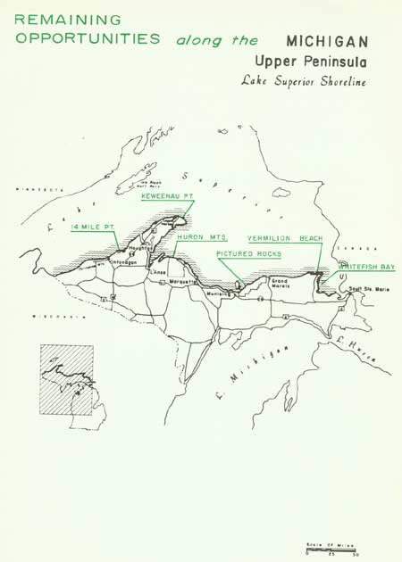
| Remaining Opportunities along the Michigan Upper Peninsula — Lake Superior Shoreline (Vicinity Map) (click on image for an enlargement in a new window) |
SUMMARY
Michigan's south shore of Lake Superior possesses an interesting array of diversified scenic shore frontage--probably unmatched on the entire Great Lakes. Contrasting sharply with the long, sand beaches west of Whitefish and Au Sable Points are the precipitous cliffs of the Pictured Rocks near Munising and the rugged conglomerate shores of the Keweenaw Peninsula. The highlands of the Porcupine and Huron Mountains, as well as the Keweenaw Peninsula, provide a mountain backdrop to this northern lake country.
Michigan's Upper Peninsula--particularly this varied north shore--is a last frontier in the recreational field. The opening of the Straits of Mackinac Bridge has improved the access to this formerly remote area and is destined to tap the refreshing experiences of the northland. Already vacationists are crowding the facilities of the Porcupine Mountains and Tahquamenon Falls State Parks as well as the four small shoreline parks that lie between. While undeveloped beaches and scenic shore environments remain, they should be acquired to meet today's expanding recreational needs as well as to satisfy future requirements.
This portion of the Upper Peninsula is unmarred by extensive commercial and sprawling city developments along its shoreline. It has experienced timber exploitation and repeated fires which, in some instances, have prevented forest regeneration. Copper mining has long been an activity of the Keweenaw Peninsula, but today it is a struggling operation. Commercial fishing, now plagued by the devastations of the sea lamprey, hangs on as one of the picturesque occupations on the Great Lakes. Such are the uses and influences of the Upper Peninsula and its north shore. It is quite conceivable that recreation on this peninsula may well take its place among the principal sources of economic wealth for Upper Michigan. To meet this possibility, the region has great potential. Although some shoreline areas are already preserved, others need protection before the opportunity is gone and their inherent values lost. There are now approximately 85 miles, or 16 percent, of the mainland shoreline in public ownership as state parks, state forests and national forests. Isle Royale National Park is the principal offshore feature now publicly owned.
To this total, it is recommended that seven additional areas with 98 miles of shoreline be added. These would include not only the outstanding elements of Lake Superior but of the entire Great Lakes. The Pictured Rocks and the Huron Mountains contain scenery as well as biological and recreational values of exceptional significance. Both of these areas, along with others being recommended, have only limited access and, because of this, many of the intrinsic natural values of the sites have been retained. If acquired and maintained in their unspoiled condition, these areas would make significant contributions to park systems, displaying the best of lakeshore scenery and environment.

| Upper Peninsula of MICHIGAN (Lake Superior Shoreline) |
FOURTEEN MILE POINT
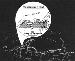
LOCATION Lying on Lake Superior's south shore, the Fourteen Mile Point area encompasses most of Sleepy and Misery Bays. Only the eastern portion of Misery Bay may be reached by automobile via county road from State Route 26. Beginning at Fourteen Mile Point, a 10-mile shoreline sweeps eastward, intercepting an inland area of nearly 10,000 acres.
DESCRIPTION Today, this site contains some of the least accessible shoreline on the southern shore of Lake Superior. State highways have skirted the area almost entirely while logging roads, many now impassable, have made the only penetrations into the region. The logging which occurred over an extensive area leaves today a relatively young forest composed of mixed hardwoods and conifers.
A nearly level terrain lies behind the beaches with only the stream courses causing any variance in the topography. These water courses wind slowly through the region until they unite to run parallel behind the beaches' barrier dune in search of an outlet.
The shore conformation includes two broad bays--Sleeping and Misery Bays. (The latter is also known as Carvers Bay.) Fine sand beaches, varying from 50 to 75 feet in width, stretch along the bay frontage between rocky sandstone points. Shallow waters cover the bay's sandy offshore bottom, whose contours are marked by several parallel sand bars. Behind the beach is a low barrier sand dune, rising only a few feet above the beach. Here, forest and beach meet.
The bays are anchored to the more resistant rocks that periodically emerge along this shore. Fourteen Mile and Willard (or Wolf) Points are such protruding features in this region where bedded sandstone defies Lake Superior's pounding waves.
PRESENT USE Due to the relative inaccessibility of the western part of this region, only a small amount of private development has taken place. Along Misery Bay there are a few private cottages. Logging roads lace much of the area; and, periodically, old abandoned logging camps are encountered. Over 3,000 acres of this proposal are state lands administered as a unit of the Baraga State Forest.
ANALYSIS The Fourteen Mile Point region has many features capable of making it a fine lakeshore recreation area. Until such time as this site is needed to meet the recreation demand, it could be managed as a state forest with emphasis on improving the forest cover.

|
| Fourteen Mile Point |
| Upper Peninsula of MICHIGAN (Lake Superior Shoreline) |
KEWEENAW POINT
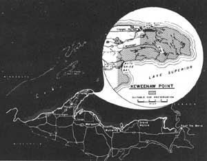
LOCATION Projecting more than 60 miles into Lake Superior, the Keweenaw Peninsula is one of the most prominent geographic features of the Great Lakes. The Keweenaw is accessible via U.S. Route 41 and State Route 26 as far as Copper Harbor, while County Route 58 leads to Bete Grise Bay. A study area shoreline here of 31 miles embraces an inland area of nearly 36,000 acres on Keweenaw Point.
DESCRIPTION Keweenaw Point features colorful conglomerate shores, several fine sand beaches and ragged, precipitous shore cliffs. Conglomerate is the most characteristic feature of the region, varying from moulded shores to disintegrated red pebble beaches. White sand beaches, particularly at Keystone and Bete Grise Bays, are striking in their contrast to an otherwise rugged shore. At Bete Grise, the Mendota Canal cuts through a fine sand beach to provide small boat access between Lake Superior and Lac La Belle. This inland lake rests along the south line of the northern Keweenaw's rough terrain in an imposing scenic setting. To the south, the Lake Superior shore is a low plain marked by old beach lines.
The peninsula's northern terrain is characterized by an uneven topography encompassing several small lakes surrounded by typical lake country forests. The mountainous character is fashioned by gentle slopes that frequently terminate in precipitous cliffs.
Historically, the Keweenaw has long been noted for its minerals, particularly copper. Today, ghost towns and abandoned mines mark the passage of the economic life of many of these ventures. The abundant recreational resources of the Peninsula offer excellent possibilities for a revival of the Peninsula's economy on a new basis.
PRESENT USE Mining companies own the major portion of Keweenaw Point and are at the present more active in logging operations than mining. Private ownerships are scattered, and some cottage site leasing on mining company land has occurred near Lac La Belle. State properties are confined to Fort Wilkins State Park and a small unit of the Baraga State Forest.
ANALYSIS The outstanding recreation features of the Keweenaw Peninsula should be preserved for public use and enjoyment -- possibly as a combined state forest and recreation unit. The problem of local tax revenue losses through public acquisition requires further study to determine how best to achieve a balance in the local economy while meeting accelerated public requirements.

|
| Keweenaw Point |
| Upper Peninsula of MICHIGAN (Lake Superior Shoreline) |
HURON MOUNTAINS
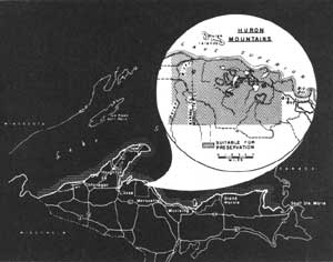
LOCATION The Huron Mountains bulge out along Lake Superior's south shore approximately midway between Duluth, Minnesota and Sault Ste. Marie, Michigan. Through highways bypass this region, but county routes from Marquette and L'Anse do reach the margin of the mountains. Within the mountains, several private roads are closed to public travel. A 22-mile shoreline extends westerly from Big Bay, setting off an inland area of nearly 100,000 acres.
DESCRIPTION The Huron Mountains sweep up from a low, level lake plain that borders on Lake Superior. The coastal line along this plain varies from precipitous cliffs to sand beaches with intervening low, broken sandstones completing the lakeshore physiography. Several small lakes rest upon this level plain, collecting the waters that cascade down the escarpment formed by the flanks of the Huron Mountains' northern edge. These mountains are among the highest in Michigan, rising over 1,000 feet above the surrounding region. Nestled among these ancient granite domes are several picturesque lakes, keynoting the northern Great Lakes scene. All of the Huron Mountain drainage system flows eventually into Lake Superior, carried there primarily by the Salmon Trout, Huron and Pine Rivers. Falls and cascades mark the mountain water courses, whereas meandering streams characterize the gentle terrain of the surrounding plains.
Remnants of old mature forests exist over portions of the mountain region, although elsewhere logging has altered the forest communities. South of the Hurons, the Yellow Dog River cuts through portions of a vast glacial moraine and outwash plain where large open stands of jack pine spread out in an almost limitless expanse. Deer and bear frequent these northern forests, while evidence of a lynx and, rarely, a wolf may be detected.
PRESENT USE A major portion of the outstanding elements of the Huron Mountains is owned by an exclusive private club. Now used as a vacation site, the natural character of the landscape has been adequately preserved. Elsewhere, logging has been a principal use on private and corporation lands. This is particularly true on the west side of the Hurons, though some isolated tracts of virgin forests are reported to remain. State properties are limited to a few scattered tracts administered as part of the Michigamme State Forest.
ANALYSIS This area offers resources for public use and enjoyment of unusual variety and scope. It is of possible national significance and should be given further study to determine the best plan for preservation.

|
| Huron Mountains |
| Upper Peninsula of MICHIGAN (Lake Superior Shoreline) |
PICTURED ROCKS
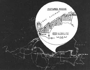
LOCATION The Pictured Rocks and their environs (on the south shore of Lake Superior between Munising and Grand Marais) display some of the most varied and picturesque scenery to be found on the Great Lakes. State road access is limited to the two nearby villages, but county roads pass through the inland region and provide access to the shore at Miners Castle and near Au Sable Point. Including the Thumb of Grand Island, 43 miles of shoreline span an inland area of approximately 100,000 acres.
DESCRIPTION This Lake Superior shoreline features 15 miles of 50 to 200-foot high "Pictured Rocks"--multicolored sandstone cliffs into which the waves have carved caves, arches and other suggestive forms. Over these cliffs two streams send small, cascading, ribbon-like waterfalls, adding variety to the lakeshore scene. The setting of the cliffs is further enhanced by the presence of three small sand beaches, hemmed in by basin rims that connect the shore cliffs. To the east of the Pictured Rocks stretch 12 miles of continuous, undeveloped sand beach and five miles of the towering Grand Sable Dunes. Perched atop glacial deposits, the windswept dunes lie nearly 200 feet above Lake Superior. These prime features are concentrated on the shoreline but a five-mile deep littoral band encompasses some 20 small lakes and ponds, three waterfalls, and extensive habitat for deer, bear and other northern wildlife. Beaver Lake and Au Sable Lake are both two miles long, have clean sandy bottoms and offer excellent possibilities for inland swimming, boating and fishing. The woodland cover, although primarily second growth, is recovering in good shape and, with adequate protection, could soon regain its original qualification as a prime forest area. Additional historic, scenic and scientific assets are included on Grand Island, lying one mile offshore at the west end of the area.
PRESENT USE Private developments are limited in extent through the area, being confined principally to Miners Beach as well as Grand Sable and Beaver Lakes. The major portion of this study area is owned by a mining company whose principal activity has been timber cutting. Public lands include a small portion of the Hiawatha National Forest together with scattered units of the Grand Sable State Forest. Most of the Grand Sable Dunes are now in state ownership and, along with the Pictured Rocks, have been designated as state park sites. A small county park is presently operated at Miners Castle.
ANALYSIS By virtue of its unique and spectacular scenery--unmatched elsewhere on the Great Lakes--this area is of possible national significance and should be given further study to determine the best plan for preservation.

|
| Pictured Rocks |
| Upper Peninsula of MICHIGAN (Lake Superior Shoreline) |
VERMILION BEACH
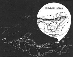
LOCATION Vermilion Beach reaches 8 miles westward from Whitefish Point to Vermilion on Lake Superior's southeastern shore. One of the principal accesses is a graveled road leading north from the termination of State Route 123 near Tahquamenon Falls State Park to Whitefish Point. Behind the beach environment, an area of 3,200 acres includes old shorelines and sand plains covered by northern forests.
DESCRIPTION In contrast to Lake Superior's western limits where sand beaches are uncommon, the eastern shores possess many continuous miles of sandy shoreline. Vermilion's beaches are typical of this southeastern region. Here, mixed with the sand are small pebbles, some of which are agates of varying quality. The storms that bring churning breakers crashing down on the shore frequently mix and add new pebbles and agates to the beaches.
A low barrier dune parallels the beach and varies from a low sand ridge to the broken elements of sand dunes. Vegetation has succeeded in stabilizing a large segment of these dunes, but the pounding surf and buffeting winds keep many of the lakeshore slopes bare. Behind the barrier dune lie a number of old, parallel beach lines. Frequently, small bodies of water occupy some of the swales lying between these beach lines, while elsewhere bogs or marshes exist. Being primarily a sand deposit of an old lakebed, the terrain behind the beaches shows very little change in elevation. Near Whitefish Point on the east, only the low rims of old beach lines break an otherwise level topography. To the west, the plain rises only slightly to form a low bluff in back of the beach west of Vermilion Point.
The forest cover has been cut over in years past, leaving a young mixed stand of typical northern hardwoods and conifers. Considerable jack pine and white birch are found near the shore, and white pine, spruce and balsam fir along with maple are not uncommon.
PRESENT USE Due to the remoteness of this region, caused by its lack of access, the amount of private development has been negligible. A considerable inland area of state owned land is administered as the Lake Superior State Forest.
ANALYSIS Completion of public ownership of all the shoreline embraced by Vermilion and Whitefish Points would give vital protection to a shore possessing fine recreational opportunities. These values could be adequately protected and retained by inclusion of this land in the Lake Superior State Forest.

|
| Vermilion Beach |
| Upper Peninsula of MICHIGAN (Lake Superior Shoreline) |
WHITEFISH BAY
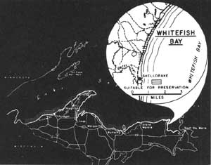
LOCATION Beginning at the Betsy River's mouth near Shelldrake, this shoreline reaches 3 miles northward toward the protecting arm of Whitefish Point. A graveled county road parallels this part of the bay as it connects Whitefish Point with State Route 123 at Tahquamenon Falls State Park. Behind the beach, a narrow ribbon of private land amounting to 600 acres fills out the interior of the study area.
DESCRIPTION Characterized by sand beaches and shallow offshore water, Whitefish Bay possesses the potential for a fine water recreation area. While pebbles comprise the major portion of Whitefish Point, their occurrence becomes less common farther south as the transition to sand beach becomes virtually complete within this study area. Here, sand bars covered by shallow water extend out into the bay from the fine sand beaches. Under the warming rays of the sun, the water temperatures rise to make ideal bathing conditions during the summer months.
Behind the beaches, a low, stabilized barrier dune parallels the shoreline. Inland, beyond the barrier dune, the sandy soils extend westward as a long, low plain with only old beach lines serving to break the even character of the land. Frequently, marsh areas are associated with the swales found between the old dune ridges.
Second growth forests predominate in this region. Scattered conifers exist through these forest lands where the shaggy tops of white pines towering above their associates are not an uncommon sight.
PRESENT USE Summer cottage development has begun north of Shelldrake and it appears destined to spread over a major share of this shore to Whitefish Point. Less than one mile west of the shoreline are the state lands of the Lake Superior State Forest.
ANALYSIS By virtue of its sand beaches, Whitefish Bay would provide a valuable water recreational area for the nearby Tahquamenon Falls State Park. Its recreation aspects would also make a substantial contribution to a state park or forest including the scenic and wild beaches of Vermilion. Due to its desirable qualities for public use, acquisition cannot be long delayed if it is to be preserved.

|
| Whitefish Bay |
| <<< Previous | <<< Contents>>> | Next >>> |
rec_area_survey/gl/mi1.htm
Last Updated: 27-Jun-2007