|
NATIONAL PARK SERVICE
Great Lakes Shoreline Recreation Area Survey |

|
REMAINING OPPORTUNITIES ALONG THE MICHIGAN LOWER PENINSULA (Lake Michigan Shoreline)
|
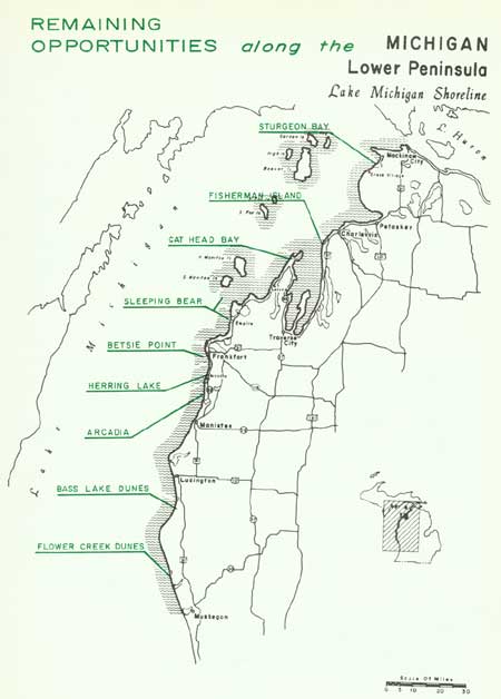
| Remaining Opportunities along the Michigan Lower Peninsula — Lake Michigan Shoreline (Vicinity Map) (click on image for an enlargement in a new window) |
SUMMARY
As a vacationland, the Lake Michigan shoreline between the Straits of Mackinac and the city of Muskegon is a "natural." Thousands of people flock to this area every summer to enjoy the sand; the scenery and the refreshing climate, along with the cultural advantages that are offered nearby. Here, towering, wind-blown sand dunes are interspersed with sheltered bays; Indian lore and legends are mixed with modern sophistication of art colonies and music festivals; regimented agricultural landscape is contrasted with natural areas rich in geological, botanical and zoological values.
Generally speaking, this northeastern Lake Michigan shoreline can be subdivided into three basic sections. The first is from the Mackinac Bridge south to and including Grand Traverse Bay. With a few notable exceptions, this shoreline along this stretch is characterized by shallow waters backed by narrow, cobble beaches and, in some cases, high bluffs. Widely known as a summer resort district, present development is primarily centered around Petoskey, Charlevoix, and Traverse City. Only two study areas were selected in this section.
The second section from the tip of Leelanau County south to Muskegon contains some of the most scenic recreation shoreline on the Great Lakes. Here, the almost continuous, clean sand beaches are backed with both low and high dunes--some bare, some covered with magnificent deciduous forests. Behind these dunes are numerous inland lakes that add scenic variety as well as other recreational enjoyment. Here, the numerous recreation possibilities are being recognized by private development which poses a threat to future public benefit of the natural resources. Six areas in this section are recommended for public acquisition.
The offshore island groups - Beaver, Fox and Manitou - make up the third shoreline section. Here, the isolation factor is a mixed blessing. Island vacations have a great appeal but access difficulties limit the number of participants. The same limitation favors the retention of natural areas where the adverse effects of man's intrusion can be kept at a minimum. Because it encompasses most of the prime assets represented by Lake Michigan islands, only South Manitou Island has been designated for public acquisition. However, it is recommended that consideration also be given to preserving one or two islands in the Beaver group for their natural values.
Northeastern Lake Michigan falls within the Region Two administrative unit of the Michigan Conservation Department. Total state ownership along the 403 miles of mainland shoreline amounts to slightly more than 10 percent. Less than 10 percent is devoted exclusively to recreation and over half of this amount is in Wilderness State Park.
The recommended additions to public ownership listed on the following pages would more than double recreation shoreline. However, the resulting 19 percent devoted to such use is not considered excessive in view of the natural values involved, the intensive use of the area and the fact that more parks bring more tourist dollars into the region's economy.

| Lower Peninsula of MICHIGAN (Lake Michigan Shoreline) |
STURGEON BAY
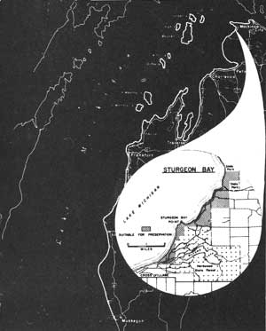
LOCATION Sturgeon Bay lies beneath the projecting arm of Waugoshance Point in Emmet County near the northern tip of Michigan's lower peninsula. A shore drive, State Route M-131, parallels Lake Michigan from Petoskey to Cross Village, and then continues as a county route along Sturgeon Bay and through the study area. Lying adjacent to the south boundary of Wilderness State Park, this shore is 17 miles southwest of Mackinaw City and approximately 30 miles north of Petoskey. A shoreline of 6.2 miles and an inland area of 2,200 acres is associated principally with Sturgeon Bay's south shore.
DESCRIPTION The broad arc of Sturgeon Bay follows an uneven shoreline marked by small indentures. Bordering the water line of this region are beaches with a mixture of sand and pebbles. Some beaches measure up to 100 feet in width, and the six foot water depth may be as much as 300 feet offshore. Pebbles are encountered frequently in these offshore waters.
Sturgeon Bay Point is a prominent feature near the south end of the bay. Here, the westerly winds have scoured the point, exposing the underlying glacial drift. Small copses of vegetation have trapped the wind-blown sand, forming an undulating terrain over the bulk of the point.
High sand dunes provide a scenic backdrop to this region, paralleling the general shoreline along most of the bay's southern shore. Many reach over 100 feet in height, exposing the raw sand of large "blowouts" amid stands of northern trees that have succeeded in stabilizing much of the dune area. Behind the dunes are thick forests of jack, red and white pine along with many northern hardwoods.
PRESENT USE Part of the southern portion of the Sturgeon Bay site lies within a unit of the Hardwood State Forests, while its northern extension reaches into Wilderness State Park. One small private sub-division is located along the shoreline a short distance north of Sturgeon Bay Point, while south of the point small tract development has occurred in several different locations.
ANALYSIS The sand dune shoreline that borders most of Sturgeon Bay's south shore would add a new scenic aspect to the Wilderness State Park and would provide further protection to its wilderness values. In addition, the high recreation values of beach and dune make this bay area worthy of consideration for addition to the state park.

|
| Sturgeon Bay |
| Lower Peninsula of MICHIGAN (Lake Michigan Shoreline) |
FISHERMAN ISLAND
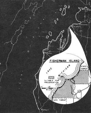
LOCATION This study area, named after the island lying a few hundred feet offshore, primarily involves a mainland area on the northeastern shore of Lake Michigan. U.S. Highway 31 parallels this segment of shoreline slightly over one mile inland. A 4-mile shoreline, including the island, intercepts an inland area of about 1,500 acres.
DESCRIPTION Lying in shallow waters, Fisherman Island itself is a small, four-acre tract covered by deciduous trees and surrounded by a shoreline of cobbles and boulders. During low lake levels it is possible to wade the slightly submerged sand bar between the island and mainland.
On the mainland portion of the study area, a sand beach borders the bay at the north end. This beach may vary in width up to nearly 100 feet before being terminated by a low barrier dune. Offshore, the water reaches a six-foot depth 500 to 1,000 feet from the beach. The adjacent bay to the south also has very shallow offshore waters but numerous boulders lie awash on and near the narrow beach. The beaches here are quite narrow with some tree growth occurring within a few feet of the water's edge.
Behind the beaches a group of low sand dunes roughly parallels the shoreline. Portions of this dune area have been stabilized by grass and forest cover, leaving active dunes primarily on the point reaching to Fisherman Island. Even here, grasses and shrubs have anchored much of the sand, reducing the amount of actively shifting dunes.
PRESENT USE All of this area is in private ownership, though units of the Pigeon River State Forest are contiguous to both extremities of the proposed site along the shoreline. Behind the dune areas, old clearings occur where farming has taken place.
ANALYSIS Located in a highly popular summer resort section of Michigan, this study area offers the best possibilities for public recreation between Traverse City and Petoskey. Here, a fine sand beach is combined with an inland area suitable for camping, picnicking and nature study. The easily accessible island adds an unusual attraction. In terms of these values, the area includes characteristics suitable for inclusion in a local or state park system.

|
| Fisherman Island |
| Lower Peninsula of MICHIGAN (Lake Michigan Shoreline) |
CAT HEAD BAY
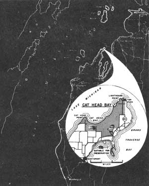
LOCATION Located on the northern tip of the Leelanau Peninsula, this bay lies between Cat Head and Lighthouse Points near the entrance to Grand Traverse Bay. Highway access to Cat Head Bay is via Leelanau County routes and State Route 201, the latter running north from Northport where it connects with State Route 22. This 3,000-acre area has a 6.3-mile shoreline on the peninsula tip.
DESCRIPTION Cat Head Bay's crescent-shaped shoreline opens to the north, exposed to winds that sweep across its shores heaping up sand in a line of dunes behind the beach. These dunes and their "blowouts" are confined largely to the bay's east side. From atop these dunes, a sweeping panorama spreads across the bay and beyond to the Fox Islands 20 miles away.
The beaches bordering Cat Head Bay vary in width up to 100 feet and are paralleled on the inland side by a low barrier dune. The beach is composed of sand and a scattering of pebbles. Offshore, the six-foot water depth lies approximately 100 feet from the beach. Cobbles and boulders occur as more common components of the beach and offshore bottoms in the areas around Cat Head and Lighthouse Points, offering sand in only small amounts.
Deciduous trees as well as evergreens are found in the forests surrounding Cat Head Bay. White cedar and balsam fir together with scattered red and white pines are the principal evergreens found along the border of the dunes. Farther inland, the forest is composed of sugar maple, beech and yellow birch along with white birch, ash and a few groves of hemlock.
PRESENT USE Public shoreline at Cat Head Bay is confined to Lighthouse Point where a small township park and a Coast Guard Lighthouse are located. Some of the interior private holdings have been cleared for farms as well as a small airport adjacent to Mud Lake. Cherry orchards are a common agricultural use in this region.
ANALYSIS The scenic charm of Cat Head Bay, accentuated by its peninsula-tip location, combines with an area possessing outstanding recreation possibilities. Excellent sites for picnicking and camping exist with a region rich in nature study potential. The features of this area are of such character as to warrant immediate steps to be taken to insure their availability for public use.

|
| Cat Head Bay |
| Lower Peninsula of MICHIGAN (Lake Michigan Shoreline) |
SLEEPING BEAR
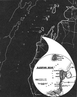
LOCATION Covering portions of Benzie and Leelanau Counties, this area stretches from Sleeping Bear Bay south to the Platte River besides including South Manitou Island. These segments encompass nearly 30,000 acres and a shoreline of 35 miles. Mainland highway access is provided primarily by State Routes 22 and 109 which parallel the shoreline one to two miles inland.
DESCRIPTION The focal point of this region is the wind-swept sands of the Sleeping Bear Dunes--long classed as one of the main scenic features of the Great Lakes. Here, atop a 400-foot high glacial moraine are perched the shifting sands and ghost forests--snags of trees once buried by the moving dunes. Below stretch the endless beaches of sand and small pebbles. A second perched dune complex towers above Empire, Michigan. These dunes resting on a moraine have been stabilized except for several "blowouts" along the lake face. Soaring 530 feet above Lake Michigan, vast panoramas open from these dunes over lake, beach, dune and forest. The southern terminus of this area is the sand plains of the Platte River. Once inundated by ancestral waters of Lake Michigan, today its sandy soils expose old beach lines and low dunes that support fine jack pine forests. Northward, along the eastern and southern flanks of the Empire and Sleeping Bear Dunes, exceptionally fine deciduous forests have become established.
Seven miles offshore from Sleeping Bear Point, South Manitou Island is an isolated composite of many features associated with Sleeping Bear and the Platte River Plains. In addition, it supports a large gull rookery while the island's flora achieves significance by virtue of a stand of huge white cedars together with Lake Michigan's only island forest of jack pine.
PRESENT USE Little development has taken place along this shore except in Platte and Sleeping Bear Bays along with several of the largest inland lakes. Public properties comprise limited Federal ownerships on South Manitou Island, Sleeping Bear and Platte River. State holdings include the Fife Lake State Forest and three state parks.
ANALYSIS By virtue of Sleeping Bear's outstanding natural features, this area is of possible national significance and should be given further study to determine the best plan for preservation.

|
| Sleeping Bear |
| Lower Peninsula of MICHIGAN (Lake Michigan Shoreline) |
BETSIE POINT
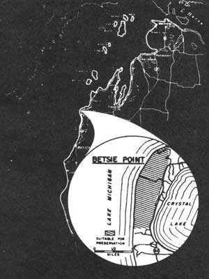
LOCATION Betsie Point lies 4 miles north of Frankfort, Michigan in Benzie County. Michigan State Route 22 passes the east line of the proposed area, while a county route leads to the Coast Guard Station on Betsie Point. Behind this 1-1/2 mile shoreline are approximately 500 acres of beach, sand dunes and forest.
DESCRIPTION The sand dunes of Betsie Point encompass a low lying point in contrast to the high bluffs found on the north and south. The dunes rarely reach more than one-half mile inland from the shore and extend little more than one and one-half miles along the beach. Though irregular in topography, the dunes seldom reach more than 50 feet in height. Dune vegetation has been only partially successful in the stabilization of the sand. Copses of balsam fir, white cedar and a few deciduous trees occupy limited areas within the dune region.
Inland behind the dunes are forests composed primarily of deciduous stock, toward which the relentless sands are moving. Sugar maple is a dominant tree found in this zone along with aspen and some hemlock. Several large "blowouts" lie adjacent to this forest edge and threaten to engulf more of the inland cover. As this sand movement continues inland, previously buried forests are uncovered and resemble the snag forests left by forest fires.
Beaches up to 50 feet in width lie before the sand dune area. Mixed with the sand are varying amounts of gravel and pebbles, resulting in a rough texture to most of the beaches. Offshore, the six-foot depth is approximately 100 feet from the water's edge.
PRESENT USE A Coast Guard lighthouse occupies several acres on Betsie Point while a few of its former buildings, now privately owned, are located nearby. Most of the development in this region is centered about Crystal Lake while other private use has converged on the fine sand beaches of Platte Bay nearby. A few cottage sites have been built along Michigan Route 22, while a private golf course development dominates the area north of Betsie Point.
ANALYSIS Betsie Point does not possess outstanding possibilities for swimming; however, its principal values lie in its open dunes suitable for hiking and exploring. Providing for such day use activities, this small area could meet a growing need for lakeshore open space amid a region of growing private developments.

|
| Betsie Point |
| Lower Peninsula of MICHIGAN (Lake Michigan Shoreline) |
HERRING LAKE

LOCATION The Herring Lake Site extends from the southern tip of Lower Herring Lake northward to the mouth of the Betsie River near Frankfort. State Route 22 parallels the general shoreline up to a mile inland south of Elberta. This Benzie County shoreline measures nearly 4-1/2 miles in length while intercepting an inland area of 900 acres.
DESCRIPTION A high morainal bluff that slopes sharply to the shoreline is the characteristic feature in this region. Atop these bluffs rest stabilized perched dunes, exposing a few "blowouts" to the sweeping lake winds. From these bluffs, some rising over 300 feet above the lake, vast scenic panoramas open along the shoreline and over the waters of Lake Michigan. The continuity of these bluffs is broken in several locations, one midway along their length and again opposite Lower Herring Lake.
The Herring Lakes are bodies of water that once were inundated by a higher level of Lake Michigan. Today they lie in a dry embayment bounded by the basin slopes, except on the west where a sand ridge restrains Lake Michigan.
Sand beaches, varying in width with the lake levels, stretch along the shoreline beneath the bluffs. Composed primarily of fine to medium-textured sands with only a scattering of pebbles, these beaches offer excellent recreation opportunities. Behind the beach a barrier dune follows the shore for over a mile south of the Betsie River and again opposite Herring Lake. Offshore, the sandy bottom slants away from the beach, passing the six-foot depth nearly 75 to 100 feet from shore.
Inland, much of the area is forested, though occasional farm clearings occur.
The forests are composed largely of deciduous stock with the pine, hemlock and other conifers scattered throughout.
PRESENT USE Private developments have taken up most of the inland shores of Lower Herring Lake, leaving only the western shore undeveloped. To the north there is little development along Lake Michigan before reaching a small public beach and scenic parking overlook near Elberta.
ANALYSIS By virtue of its recreation and scenic values, this shoreline possesses the characteristics of an unusually fine public use area. Swimming, boating and camping would find suitable development locations to adequately meet future expanding recreation needs.

|
| Herring Lake |
| Lower Peninsula of MICHIGAN (Lake Michigan Shoreline) |
ARCADIA
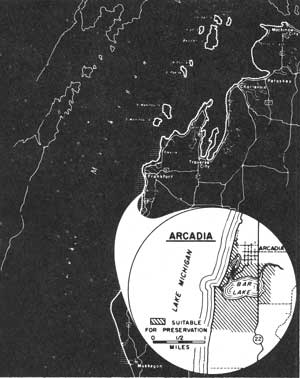
LOCATION The Arcadia site is associated with a Lake Michigan shoreline of 1.3 miles in the vicinity of Bar Lake in Manistee County. Michigan State Route 22 passes through the village of Arcadia, lying on the east flank of the proposed public use site. Frankfort, Michigan is approximately 12 miles to the north, while Manistee is 22 miles south of Arcadia. Behind the 1.3 miles of Great Lakes shoreline is an inland area of nearly 700 acres.
The sand beach between Bar Lake and Lake Michigan is one of this region's focal points. The medium textured sand forms a beach that seldom exceeds 50 feet in width. Pebbles are mixed with the sand on the beach as well as offshore. Offshore, the bottom slants rather sharply, reaching a six foot depth in 20 to 40 feet from shore. Coarse sand and pebbles also comprise the lake bottom in this zone.
DESCRIPTION Bar Lake lies in a dry embayment surrounded on three sides by upland bluffs, while on the fourth side a low sand rib separates it from Lake Michigan. At one time, an artificial water channel connected the two lakes, but this has now been choked to a small trickle by the shifting sands. The breakwater that once protected this channel entrance has been responsible for sand accumulation that has widened the beaches, particularly south of the harbor entrance. Narrow sand beaches may be found along portions of Bar Lake's shore.
Forests of northern hardwoods clothe the slopes surrounding Bar Lake. Occasionally, conifers are found mixed with oak, ash, birch and maple. Beach grasses are common on the sand ribs along Lake Michigan.
PRESENT USE The village of Arcadia, lying near the northeastern tip of Bar Lake, has been influenced over the years by the fortunes of the lumber market. A mill site for a furniture company is located along this lake's shore where its holdings affect an appreciable portion of the lake shoreline. Some clearing has taken place, permitting limited farming elsewhere along the shoreline, but cottage development has not been extensive.
ANALYSIS The recreation potential of the Arcadia site is dependent upon the feasibility of keeping the short channel open between Lake Michigan and Bar Lake. The latter lake would be an excellent site for small boating activities in addition to harbor and swimming developments.

|
| Arcadia |
| Lower Peninsula of MICHIGAN (Lake Michigan Shoreline) |
BASS LAKE DUNES
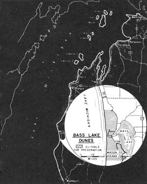
LOCATION The Bass Lake Dunes lie 7 miles south of Ludington and 2 miles north of Pentwater. Most of this site lies in Mason County's southwest corner and extends slightly into northern Oceana County. Bass Lake is the principal inland feature, lying near the eastern base of the sand dunes paralleling the Lake Michigan shore. County routes leading from U.S. Highway 31 come within 1/4 mile of the shoreline at the Bass Lake outlet. The dune complex of nearly 600 acres is fronted by a 1.9 mile shoreline.
DESCRIPTION The Bass Lake Dunes rise steeply above the waters of Lake Michigan to heights between 100 and 150 feet. A barrier dune is virtually absent along this beach, leaving a steep face exposed to the action of wind and water. These dunes extend less than a mile inland to the small basin holding Bass Lake. The narrow dune strip is a tangled complex of dune ridges, valleys and steep sand slopes.
The dunes are well stabilized except on a few of the lakeside slopes. Stabilization has been accomplished by forests of red oak, white pine and white birch together with additional scattered hardwoods. Beach grasses along with a few shrubs have also contributed to holding the sand in place.
The beaches are approximately 50 feet wide, composed primarily of sand but containing a mixture of small pebbles. Offshore, the six-foot water depth varies from 100 to 150 feet from the edge of the beach. Sand and small pebbles are also found in this zone of shallow water.
PRESENT USE Scattered cottage construction has occurred along much of the county road that parallels the eastern flank of the sand dunes separating Bass Lake from Lake Michigan. This private development has centered primarily along the west shore of Bass Lake. The steep Lake Michigan shore topography has prevented extensive development within the dunes.
ANALYSIS Public ownership of the Bass Lake Dunes and their Lake Michigan beaches would permit general access to these shores for swimming as well as hiking and nature study among the dunes. The preservation of the dune forest in its role of stabilizing the sand is an important consideration to the developments along Bass Lake's west shore. These dunes and beaches, set aside as a county or township park, could adequately serve the local public recreation and conservation needs.

|
| Bass Lake Dunes |
| Lower Peninsula of MICHIGAN (Lake Michigan Shoreline) |
FLOWER CREEK DUNES
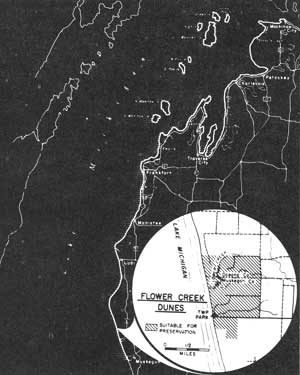
LOCATION The Flower Creek Dunes site overlaps the southern edge of Oceana County from the northwest corner of Muskegon County. Twenty miles to the south is the city of Muskegon, accessible by county routes and U.S. Highway 31. This dune and beach area, with its shoreline of 1.7 miles and inland area of 1,200 acres, encompasses the principal undeveloped features near the mouth of Flower Creek.
DESCRIPTION Beaches composed of fine sands vary from 50 to 175 feet in width along this portion of northern Muskegon County shoreline. Frequently, a low barrier dune separates the beaches from the high inland dunes that crest occasionally 100 feet above the lake. Elsewhere, the lakeside of the dune has been truncated and its bluff face rests on the beach not far from the water's edge. Occasional wind erosion has stirred the dune sand, cutting "blowouts" and altering the barrier dunes into broken sand communities.
Offshore, several sand bars lie parallel to the shore, a characteristic of a large part of Lake Michigan's eastern shore. Shallow waters are associated with these sand bars, only the six-foot depth lying up to 150 feet offshore in the Flower Creek region.
The sugar maple-beech-yellow birch northern hardwood forest type is found here as well as its common associates--white pine and white birch. Forests, together with beach grasses and shrubs, clothe the dune topography and serve to stabilize these sand hills, preventing a rapid encroachment on the inland areas.
PRESENT USE Meinert Park, a small county recreation area south of the mouth of Flower Creek, provides a small beach park for public use as well as being the principal public access to the shoreline in this region. East of the dunes, much of the inland area has been cleared and is used for pasture and cultivation. Cottage development is not extensive but some occurs near Meinert Park in addition to other scattered locations.
ANALYSIS The beach qualities of fine sand and shallow offshore water, set against the pleasing backdrop of dunes and forest, provide an excellent site for a lakeshore recreation area. Suitable sites exist for picnicking and would be valuable additions to other public use facilities. The enlargement of Meinert Park to provide these facilities would be worthwhile in meeting projected recreation needs.

|
| Flower Creek Dunes |
| <<< Previous | <<< Contents>>> | Next >>> |
rec_area_survey/gl/mi3.htm
Last Updated: 27-Jun-2007